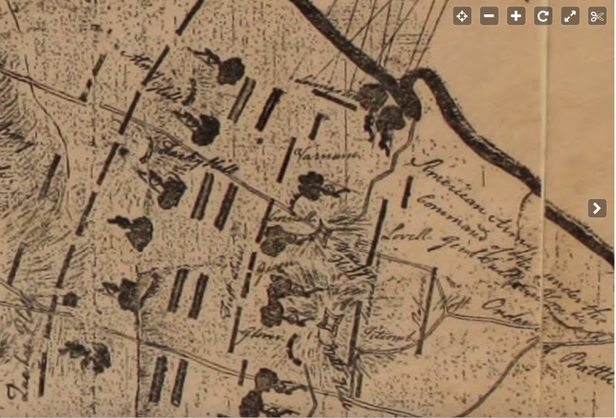

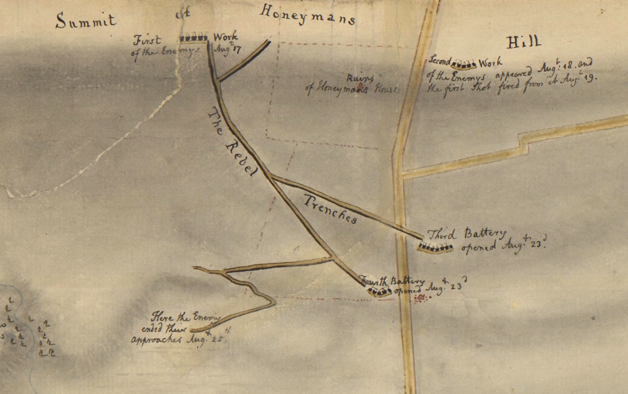


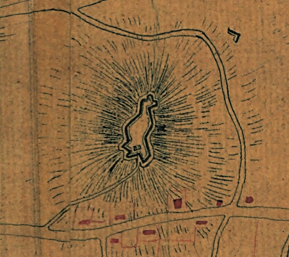
Huntington Library Map of North Portsmouth

zS


Gloria Schmidt's research notebook of topics in Portsmouth, RI history.
May 31, 2022
Portsmouth History Battle of Rhode Island, Siege of Newport Leave a comment
Huntington Library Map of North Portsmouth
zS
May 16, 2022
Portsmouth History Battle of Rhode Island, Heritage Park Leave a comment
The Revolutionary War is part of our story here in Portsmouth. I have been learning about that time in our history as part of an effort to restore Butts Hill Fort. Heritage Park is another place where you can quietly imagine the Battle of Rhode Island and the fighting that took place on Turkey Hill. If you are a “Hamilton” fan you may remember the character of John Laurens, a good friend of Alexander Hamilton. Laurens was a central figure in the fight.
Seth Chiaro of the Butts Hill/Battle of RI Association penned this description of the action based on Christian McBurney’s masterful book “The Rhode Island Campaign.” As you wander around the hillside at the park, imagine this:
“Hessian troops under Captain Von Malburg pursued American Col. Laurens Regiment to Turkey Hill. Laurens men took up a strong defensive position on top of Turkey Hill. Col. Lauren sent a request for reinforcement to General Sullivan. Sullivan responded with orders to ‘fall back to the main line’. General Sullivan sent Webb’s Connecticut Regiment to support Laurens retreat. Ameican and Hessian units engaged on Turkey Hill before the Americans fell back. Laurens Regiments fell back to General Nathanael Green’s position to the right of Butts Hill. By 8:30 am the Hessians had secured Turkey Hill.”
Turkey Hill was lost and the Americans had to retreat off the island, but the Americans fought well and the retreat was successful in preserving men and weapons for another fight.
Heritage Park is located off of Hedley Street/High Point on the hill behind the Transfer Station. Walk up the hill and you will find Nathan Minese’s excellent display on the Battle of Rhode Island.


May 11, 2022
Portsmouth History Butts Hill Fort 1 Comment
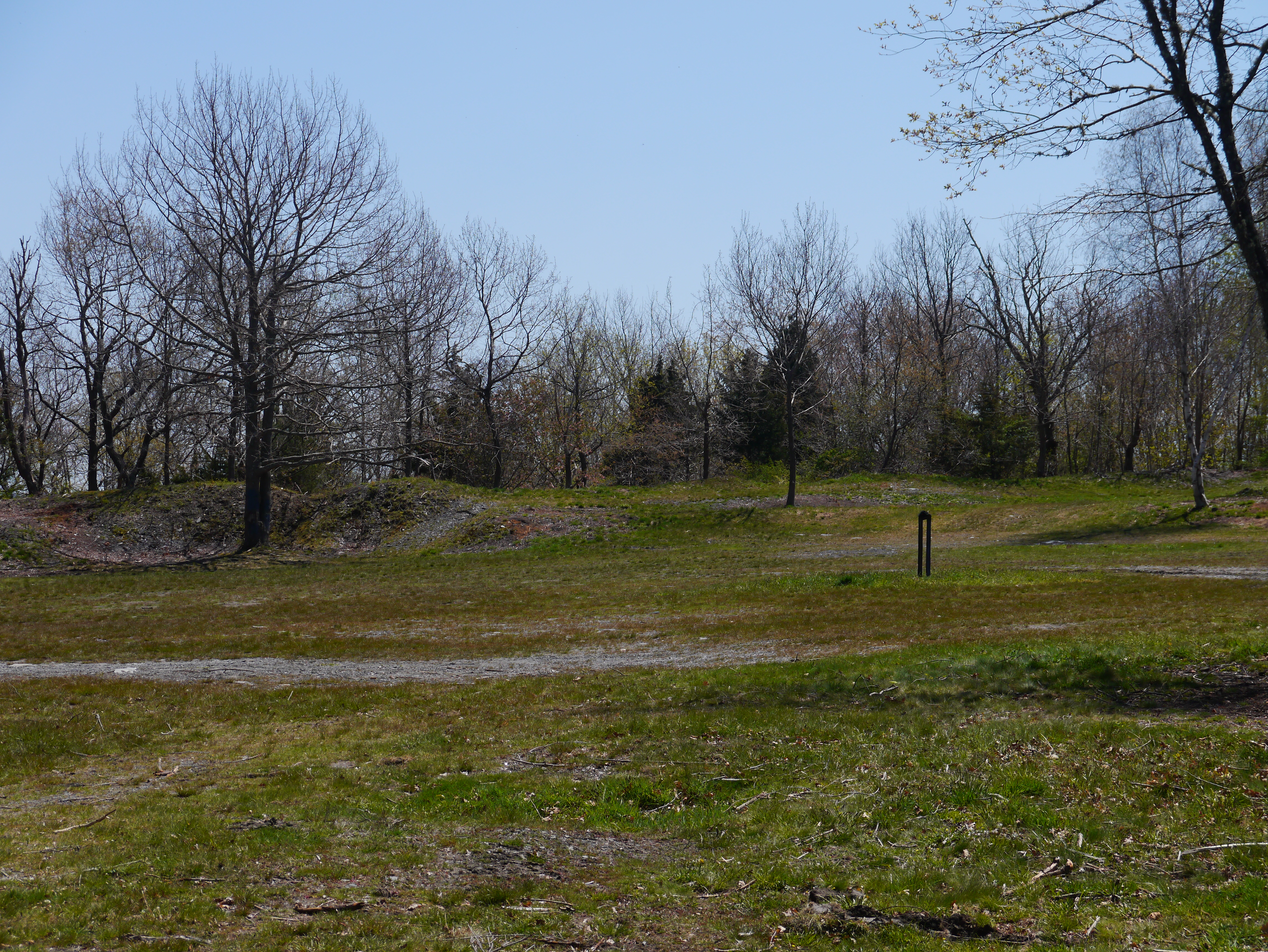
A fort is emerging:


May 8, 2022
Portsmouth History Leave a comment
Mother’s Day had its roots in Portsmouth’s own Julia Ward Howe.
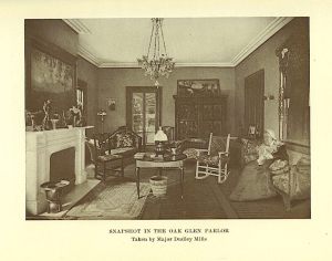 Julia in her Oak Glen Parlor
Did you know that Julia Ward Howe was the first to propose a Mother’s Day? She envisioned it as a Day of Peace in protest to war?
“Arise, then, women of this day! Arise all women who have hearts, whether our baptism be that of water or of tears!… We women of one country will be too tender of those of another country to allow our sons to be trained to injure theirs. From the bosom of the devastated earth a voice goes up with our own. It says “Disarm, Disarm! The sword of murder is not the balance of justice.”~Julia Ward Howe, 1870
From her Mother’s Day Proclamation for Peace
She wrote in Reminiscences in 1914: “I had desired to institute a festival which should be observed as Mother’s Day, and which should be devoted to the advocates of peace doctrines. I…
View original post 279 more words
May 2, 2022
Portsmouth History Butts Hill Fort Leave a comment
Stop 1: At Stone Wall: An Introduction:

We welcome you to Butts Hill Fort. It may be difficult to understand what you can see today at the fort. The Butts Hill Fort Restoration Committee as part of the Battle of Rhode Island Association is working towards a time when there are marked trails, observation posts of three battle vistas, signage and QR codes to scan for more information. Meanwhile, we hope this tour helps to explain what you see at the fort.
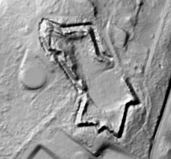
Butts Hill Fort (or Windmill Hill Fort) evolved along the way. The British called this area Windmill Hill because it was a traditional site for a windmill. The Americans called this area “Butts Hill” after the John Butts family that held the land when the war began. The outlines we are seeing date from the improvements made by the French (with the help of Americans) in 1780-1781. If you look at a LIDAR image of what the fort looks like under the vegetation, you would see the outlines clearly.

We can see ramparts – large earthen mounds used to shield the inside of a fortified position from artillery fire and infantry assault. The ramparts protect a battery which is a cluster of cannons in action as a group.
North battery ramparts: The oldest portion of the fort. It is intact except for its south wall which opens to the parade ground.
South battery ramparts: The north, south and east faces of this battery’s ramparts are basically intact. The West ramparts were removed during the expansion of the fort when the French and Americans modified it (1780-1781).
Parade Ground: Place where soldiers practice or have parades.
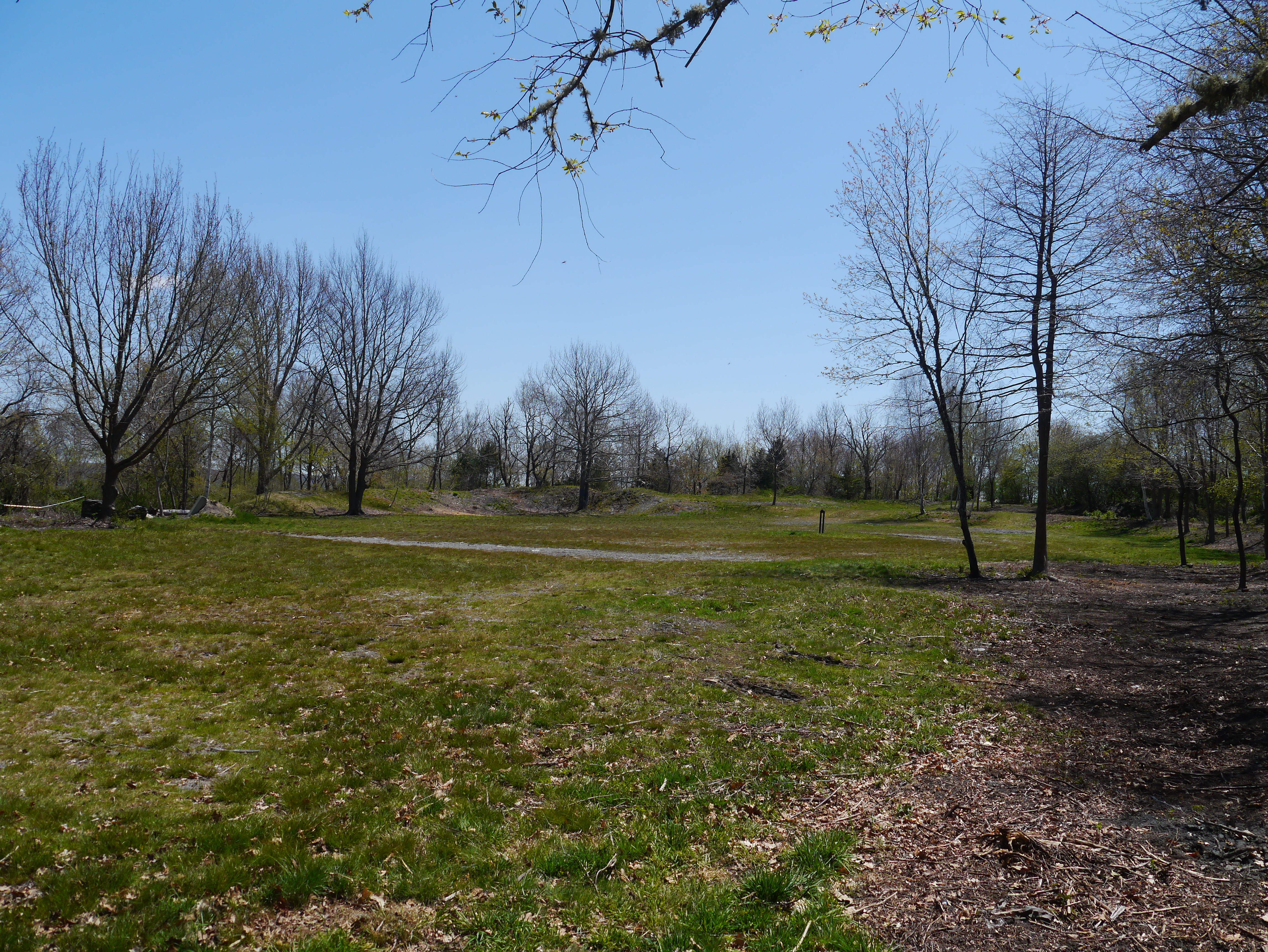
At the Stop 2 at the North/East rampart and moat. Butts Hill in British Hands
Here we see the North ramparts with moat or ditch and glacis. At the base of the ramparts is the moat (depression surrounding a fortification). The moat was a natural result of early methods of fortification by earthworks, for the ditch produced by the removal of earth to form a rampart made a valuable part of the defense system with the glacis (an embankment sloping gradually up to a fortification, so as to expose attackers to defending gunfire) descending to the north.


If what we see today at Butts Hill Fort is the outline of the modifications made by the French and Americans, what was the fort like just before the Battle of Rhode Island?
We start the tour with the oldest section – the North ramparts.
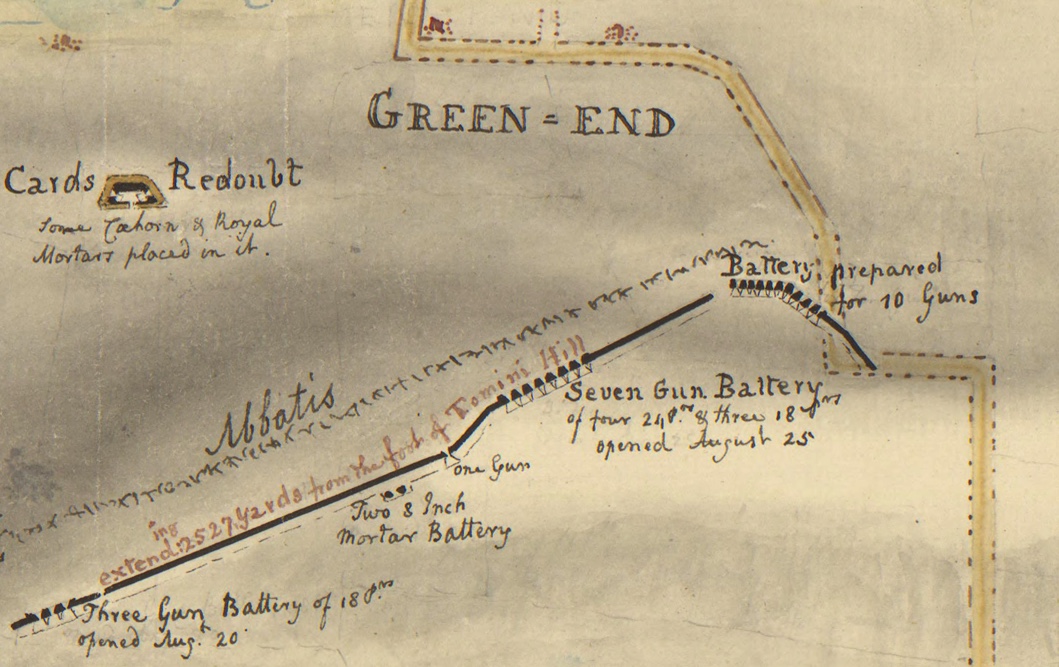
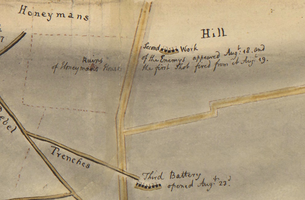
The Rebels had fortifications across in Bristol and they would often direct fire at the troops stationed by the Aquidneck Island side of the Bristol Ferry crossing. The British are beginning construction to enlarge the American fortifications.
Portsmouth residents are used as forced labor to construct fortifications for the British.
Sept. 17, 1777: “We are at present very busy in fortifying different posts on the Island; and there are already more works planned and traced out, than can possibly be finished by the end of December. …… A fortified Barrick on Windmill hill for 200 men.” (From Mackenzie diary).
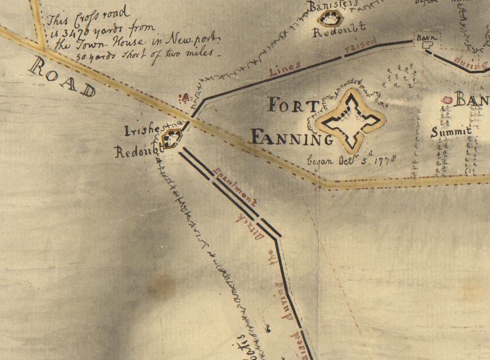
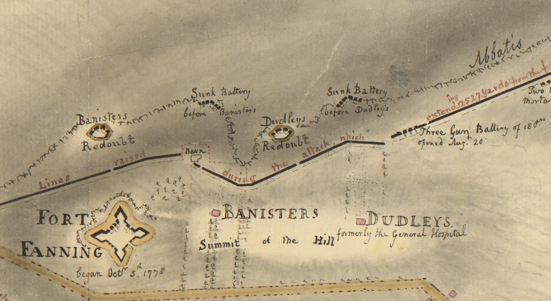
Blueprints of the British fort plans and an overlay done by Dr. Abbass in her plans for Butts Hill Fort help us to visualize what the fort looked like just before the Battle of Rhode Island. Some of the fortifications were in what is now a residential area. We need to know other terms to understand the visuals.

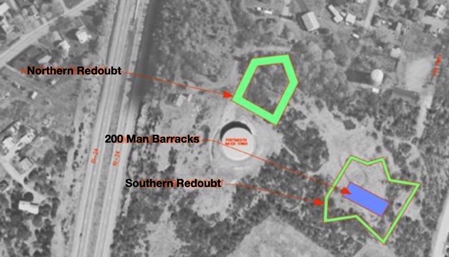
Redoubt, (pronounced rih-dowt): An enclosed field work which had several sides and was used to protect a garrison from attacks from several directions. A redoubt could also extend from a permanent fortress.
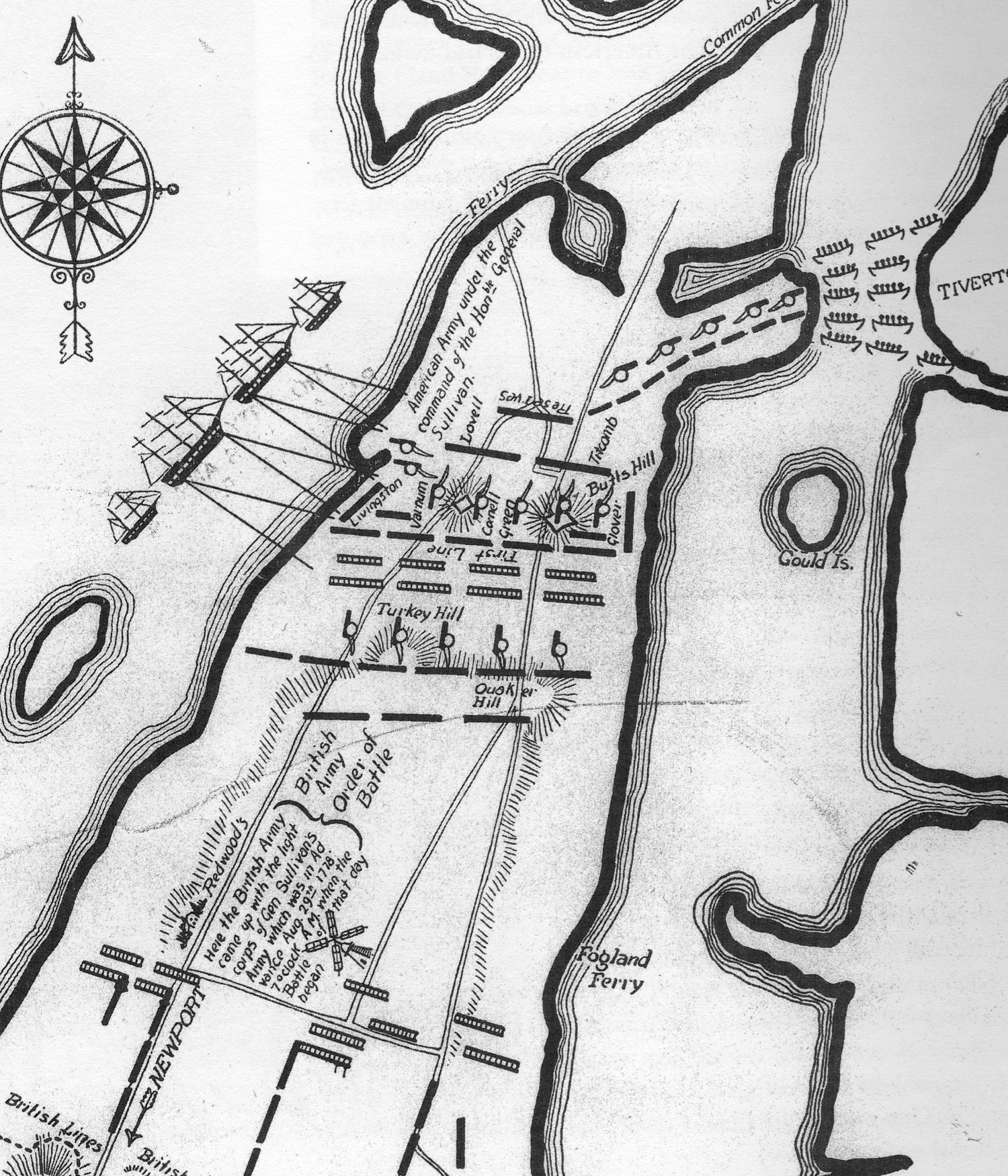
Stop 3: South Ramparts: Role of Butts Hill in the Siege of Newport and Battle of Rhode Island: Butts Hill in American hands.
We are at the southern fortifications. This part of the story takes us to the three weeks in August of 1778 when the Americans held this high position during the Siege of Newport and Battle of Rhode Island.

Drone images from Butts Hill illustrate what a commanding view was possible from this location. The British were concerned with the view of possible American invasions from the north from Bristol and the east from Tiverton. For the Americans, however, the view south was essential.

July 29th: d’Estaing met with American Commanders when he arrived at Point Judith.
August 9th: Fearing an attack, British forces abandoned Butts Hill and General Pigot withdrew his forces to Newport as the French were landing on Conanicut (Jamestown). Sullivan discovered that the British had abandoned Butts Hill, so he and his troops crossed over to Aquidneck and occupied the high fortifications. He called for the heavy cannon at Fox Point to be moved to Portsmouth.
August 12-13: A hurricane hit that destroyed men, horses, camps and supplies on both the British and American sides. The storm caused the French Navy to abandon attack in Newport.
August 16: As the Americans built earthworks and dug trenches toward Newport, American reserves and the sick who were healthy enough to do garrison work remained at Butts Hill which served as Sullivan’s headquarters.
August 26: Americans now know that the British fleet is coming and that it would be at least three weeks before French would arrive. They begin to send their heavy cannon back to northern locations like Butts Hill. General Sullivan began to prepare for a retreat. This was not a hasty retreat.
August 28th: (From Sullivan’s letter to Congress after the battle): Sullivan details the positions of his forces on the evening of August 28, 1778.

“On the evening of the 28th we moved with our stores and baggage, which had not been previously sent forward, and about two in the morning encamped on Butts’s Hill, with our right extending to the west road, and left to the east road; the flanking and covering parties ____further towards the west road on the right and left.”
August 29th, 1778: What was going on around Portsmouth during the day of the battle?
West Main Road and Union Street Engagement:
During the early hours on August 29th around 7:00 AM, Hessian Chasseurs [rapid movement soldiers] made contact with American forces near the intersection of West Main Rd and Union Street. A small engagement took place from that area and would eventually lead towards the Lawton Valley. The Hessians would eventually break the American line with Artillery.
East Main Road and Union Street Engagement:
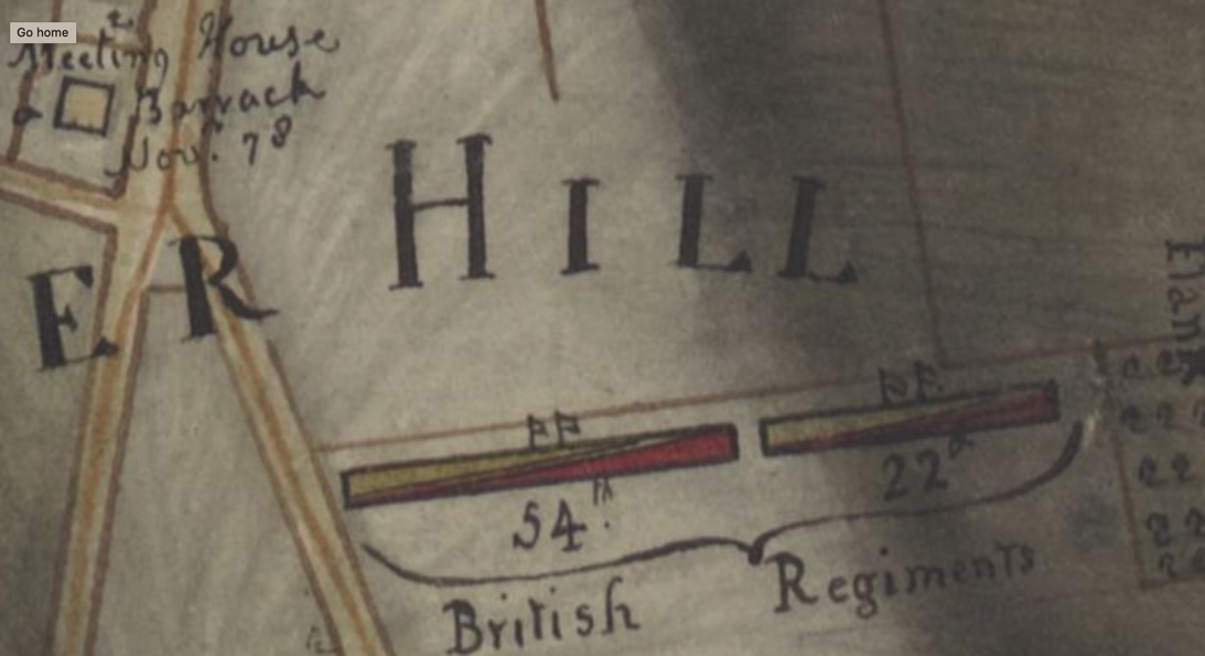
By 8:00 AM the British 54th, 22nd, 43rd, and the 38th Regiments of Foot are ambushed by Col. Nathaniel Wade’s American picket line. The 43rd took pursuit down Middle Road while the 54th, 38th, and 43rd continued down East Main Road.
Turkey Hill Engagement
German Captain Von Malburg pursued Col. Laurens Regiment to Turkey Hill. Laurens men took up a strong; defensive position on top of Turkey Hill. Col. Laurens’ Regiments fell back to General Nathanael Green’s position to the right of Butts Hill. By 8:30 AM the Hessians had secured Turkey Hill.
Quaker Hill Engagement:
The British units were now engaged on Quaker Hill. The British forces formed a line that extended from East Main Road to about where Sea Meadow Drive is now located. Americans were also formed between the Quaker Meeting House; and Hedly Street. Sullivan ordered the units fighting on Quaker Hill to retreat back to the mainline around Butts Hill Fort. The engagement on Quaker Hill lasted a full hour. The British attempted to attack Butts Hill Fort but the 18-pound cannons from the Fort kept the British from advancing.
Lehigh Hill Engagement (Durfee’s Hill)
General Nathanael Greene held the right flank of the American Army and along the right-wing stood a small artillery redoubt. This was a vital position for both sides. The 1st RI Regiment (The Black Regiment) was under the direct command of Major Samuel Ward who was commanded by Col. Christopher Greene. The Hessians tried multiple times to take the position. On the third attempt, the 2nd RI Regiment supported the 1st RI Regiment. As the 2nd RI Reg. approached the redoubt the Hessians were attempting to climb the walls. The Hessians retreated to Turkey Hill. Both sides exchanged cannon fire throughout the night.
The retreat plan in Sullivan’s words: “The heavy baggage and stores were falling back and crossing through the day; at dark, the tents were struck, the light baggage and troops passed dawn, and before twelve o’clock the main army had crossed with the stores and baggage.”
Stop 4: At the parade grounds

In December of 1779 the British finally departed from Aquidneck Island. The Americans regained possession of Butts Hill. The French arrived on Aquidneck Island on July 11, 1780 and the island was again occupied by troops. In October of 1780 one American militiaman would report in a letter:
“…there are about 7500 Men on the Island at the Several ports, 5000 of which are French, at Newport, 2000 Three Months Men, at this place and 500 Continentals, under Col. Greene of this state.”
The allied French and American forces felt secure, but they continued to prepare to defend the island. On Butts Hill there were American troops assigned to support the work of the French troops in restoring the fortifications. Through the summer and fall of 1780, Butts Hill was actively being enclosed and made into a fort by the Americans and their French allies. This is the fort shape we recognize today
Fort building was hard work. One entry records that the American wagons are bringing loads of stone to the works at Butts Hill Fort. They are building a “sally port” which is a secure, controlled entry way to an enclosure like a fort. All tools must be returned to the engineer. Members of the Black Regiment continued the “works” at Butts Hill Fort once the Massachusetts militias departed.
When Did Butts Hill become a Fort?
“The fortifications there were called ‘works’ from 1775/6 to 1780. There was never a ‘Windmill Hill Fort’ because the Fort did not exist until the French combined the separate works in 1780/81 and by that time the hill was called Butts Hill.”
Going back to the revolutionary terminology guides (American Battlefield Trust Glossary) clarified things for me.
Fort: fully enclosed earthwork; a fortified building, enclosure, or strategic position.
The British works at “Windmill Hill” were fortifications. When they arrived on the island they took over an American militia made natural (hill top) defensive position that was a temporary construction of wood and soil.

The Edward Fage map (1778) shows a second redoubt – the Southern Redoubt – was added to the fortifications. This was the condition of the fortifications when the Americans returned to Aquidneck Island in August of 1778.
We think of the Black Regiment’s valor during the Battle of Rhode Island, but I am discovering more ties between the First Rhode Island Regiment (commanded by Col. Christopher Greene) and the construction of the fort at Butts Hill. According to pension petitions, they helped the French soldiers and masons complete the job of re-enforcing the fortifications at Butts Hill. Fifty of their soldiers were detached to help the French move their artillery. After two calls back to Aquidneck Island, they would later join the American Army on the march south and participated in the final battle at Yorktown.
Stop 5: At the memorial
“Butts Hill Fort. These fortifications erected by the British 1777 were occupied by the Americans 1778 becoming the island base of the Continental Army under General Sullivan in the Battle of Rhode Island. They are consecrated to the immortal memory of those brave men who upon August 29, 1778 withstood the assaults of the more numerous highly trained British Army under General Pigot. Dedicated to posterity by the Newport Historical Society, August 29, 1923.”

This memorial stone was dedicated with some fanfare. There were speeches and battle reenactments, marching bands and the blast of cannons. This sacred piece of land was saved from being a housing development by the then President of the Newport Historical Society, Rev. Roderick Terry. He personally bought the property (and Fort Barton as well) and gave them to the Society. This gift came with some restrictions:
*The Newport Historical Society and its successors were to forever “preserve, keep and maintain” the property as a monument to those who fought in the Revolutionary War.
*That the property will always keep the name “Butts Hill Fort.”
*That the property should never be used for monetary gain.
The Newport Historical Society could not maintain the fort. In 1968 the land was transferred to the State and on to the Town of Portsmouth. Terry’s restrictions on the property remain today as the responsibility of the town of Portsmouth.
The Butts Hill Fort Restoration Committee aims to fulfill Rev. Terry’s mandate to preserve, keep and maintain the property as a monument to those who fought in the Revolutionary War. The Committee is working on a land management plan to restore the fort and create an open space area of walking trails and informational signage. The three acres of land with the fort provide ample space for major re-enactments.
As the anniversaries of the American Revolution (2026) and Battle of Rhode Island (2028) draw near, the task of “preserving” the fort and ensuring that it is a monument to those who fought in the Revolutionary War becomes even more vital.
