Information from the Huntington Library map gives us a picture of the fortifications at Butts Hill and other locations in Portsmouth during the British Occupation. The map’s purpose to show “the British posts of defence as compleated during the possession of Rhode Island, from the 8th of Dec. 1776 to the 25th of Oct. 1778.” It covers only the Northern portion of “the Township of Portsmouth”.
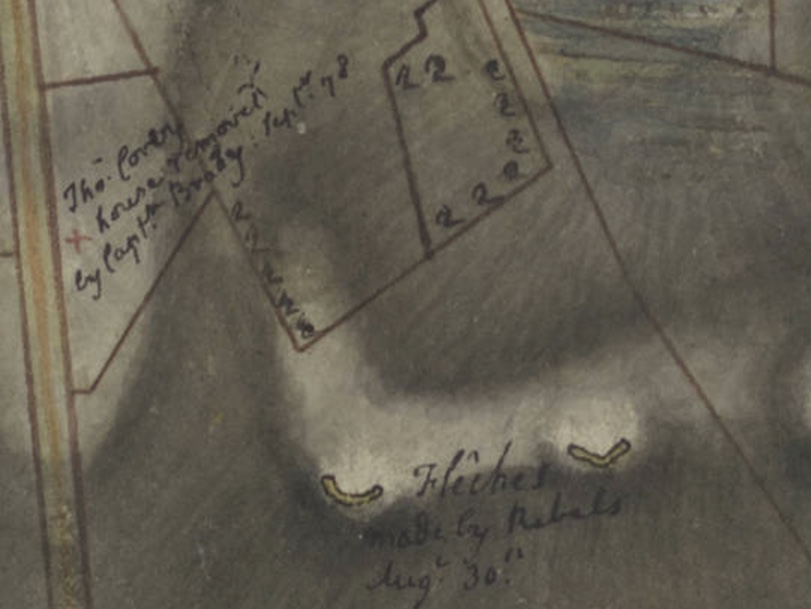
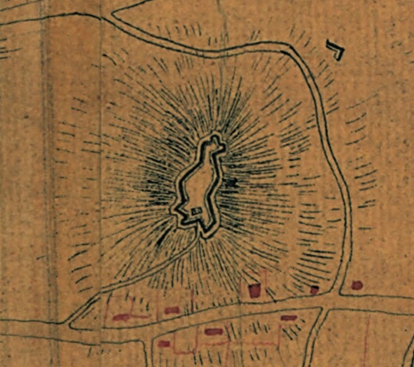
The map adds to our understanding of the structure of Windmill Hill (Butts Hill) Fort at the time of the Battle of Rhode Island. On the map you can see the abatis around the Windmill Hill Barrack and the Redoubt and Battery. The fortification is dated from 1776, and that confirms that it was begun by the Americans.
The map even provides information on Rebel constructed fortifications that the British destroyed. To the left of the depiction of the Windmill Hill is a handwritten note: “All the works in colored yellow were made by the Rebels August 30, 1778 but immediately after their retreat were filled in by us.” Another part of the map shows “fleches” made by the Americans on August 30, 1778. This was a new term for me. It derives from the old French word for arrow. “An earthwork consisting of two berms forming an angle with an open gorge.”
“Fleches” made by Rebels
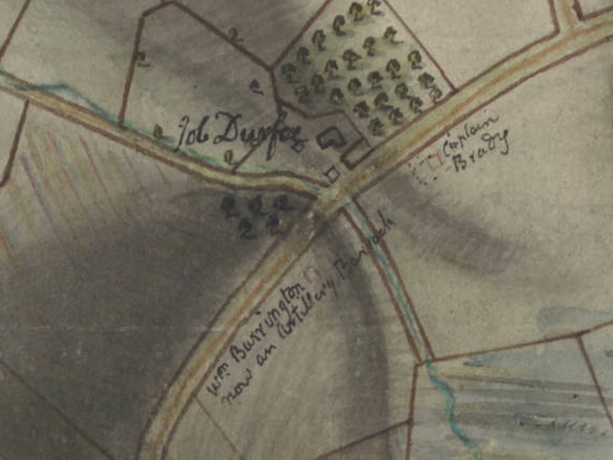
On West Main Road, southwest of Butts Hill Fort, there is an artillery redoubt listed as made in September of 1776. This also must have originated with the Americans. Looking at a Fage map, this redoubt might be labeled as “Burrington Hill.” Durfee’s Hill and Lehigh Hill are other names for it.
There are handwritten notes that add information like what structures in Portsmouth became barracks, whose orchards were cut down, and the location of local homes by owner’s names.
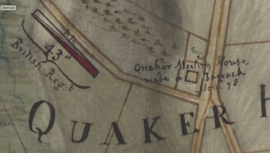
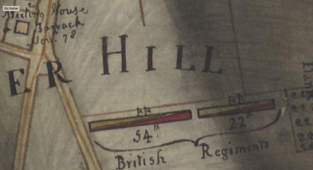
Quaker Meeting HouseWest Main Road
The British positions for the Battle of Rhode Island are quite prominently labeled.
Maps provide a prime source of information on the British fortifications on Aquidneck Island, and the North Portsmouth map from the Huntington Digital Library provides some interesting information. From the notes we get a glimpse of what the American fortifications were before the British Occupation. In some cases the British enlarged what had already existed. In other cases they constructed fortifications to secure their own needs.
Starting at the Bristol Ferry area:
Looking at a modern map the location of this redoubt seems be where the Bristol Landing Condos are today. The note says “Left by the Rebels ___1775 nearly finished.” The diagram in the Henry Clinton Collection of the William Clements Library gives us more details.
A diary entry from a British soldier, Frederick Mackenzie, gives us an idea of the fort changing hands in the initial actions after the occupation.
“Dec 8th 1776 – The Army landed this morning at Weaver’s Cove near Mr. Stoddards House… The first embarkation under General Prescott, marches as soon as formed to the high road from Newport to Bristol Ferry, a short distance from the landing place, and finding that the few of the Enemy who were on the Island, had retired in haste towards the N. End of it, he pursued them to the ferries, where he took a few prisoners and a 9 lb cannon; and save a great many cattle and sheep which they had not time to Carry off.
The Rebels abandoned a well situated fort at the N. End of the Island yesterday, without attempting to defend it. It in some measure commands the passage to Bristol by the ferry.”
Heading east on the map we see the fortifications heading toward Common Fence Point.
The redoubt by the Lawton house was labeled “made a Redoubt July 1776 now demolished”. That would have been an American fortification. Looking at a map today, it seems to be in the Anthony Road/Boyd’s Lane area to the south of Town Pond. In the direction of Common Fence Point there is a line of “abbatis” which is an obstacle made by cutting down trees, interlacing them and having the sharp points face the enemy. What we call Anthony Road was labeled Common Fence Road on the map.
The map labels a “Common Fence Redoubt” but the modern location is actually closer to East Main Road. There were fortifications toward Howland Ferry. We don’t think of a bridge being on Park Avenue, but early maps show a bridge there. The Bridge Redoubt is listed as September of 1776 which would have made it an American fortification originally.
A map made by Fage in 1778 that is part of the Clinton Collection at the Clements Library helps us to view the fortifications as a whole. One would think that the Common Fence Redoubt would be on Common Fence Point and the Bridge Redoubt would be close to the bridge to the Howland Ferry, but their locations on the map seem to be somewhat puzzling. Perhaps they were guarding the way from Common Fence Point and guarding the way from the bridge. The positions of the redoubts put them closer to established central roads. Howland Ferry was an important location. It is close to where the remains of Stone Bridge are today. It was a narrow spot between Aquidneck Island and the mainland at Tiverton. From Mackenzie’s Diary: Oct. 20, 1777 In order to strengthen the post at Howland’s bridge, an abbatiss of large apple trees from the neighboring Orchards was thrown across the Neck about 200 yards this side of the bridge, which will prevent the enemy from advancing in that part with Cannon or any considerable number of troops without first removing them, which will take u some time and must be done under our fire.”
Oct 21, 1777 – “We have had some convincing proofs of late of the bad construction of Howland Bridge Redoubt. The 9 pounders place in the right embrasure could not be brought to bear on the ground from which the Rebels fired the night of the …”
Nov. 26, 1777 – “An Abbattis was made this morning from the shore at the Mouth of the town pond for 300 yards o the right along the edge of the pond, which is passable at low water.”
March 16, 1778 “The 43rd regiment having undertaken to supply themselves with the necessary quantity of wood from Commonfence Neck, during the time they continued on duty at the advanced posts,& having employed several carts yesterday in drawing away what had been cut near Hick’s orchard…”
Our community has special locations where we can get in touch with our Revolutionary War history.  Locations in Portsmouth, Middletown, Newport, Jamestown and Tiverton are places where "history happened."  There are monuments to French General Rochambeau, The Rhode Island 1st Regiment and to the Battle of Rhode Island.  In some locations (like Butts Hill Fort), you can actually see the earthen work fortifications.

Below is a link to an interactive map where you can find out more about the locations in our community.  Be sure to click on the button for more information.  There are links to websites and even videos that help explain the importance of the site.
What was Portsmouth like during the British Occupation? What happened during the Battle of Rhode Island? Who lived in Portsmouth during this time and what happened to their property? These are questions I have been asking as I do research for Butts Hill Fort and the Battle of Rhode Island. Recently I was able to get more answers through poring over an online map recently found by a member of the Butts Hill Fort Restoration Committee. It is part of the map collection of the Huntington Library, but there are some mysteries about it. Usually a map lists a “maker” – the person who drew the map. This map lists no maker, but it is clear that the maker was part of the British occupying forces. The Legend reads:
“Plan of the northern part of Rhode Island in the township of Portsmouth. Shewing the British posts of defence as compleated during the possession of Rhode Island, from the 8th of Dec. 1776 to the 25th of Oct. 1778. When the Siege of Newport was raised after the Attack of the French and Americans in August 1778. The Enemy retreated the 29th and remained two days in possession of Wind-Mill Hill. The Kings Troops pursuing them took the Position upon Quaker Hill as represented in the Plan, till the Enemy totally vacated the Island the 1st of September, 1778.”
The map itself is neatly done, but there are interesting notes here and there. This blog will feature some of the notes about Portsmouth citizens and what happened to them during the Occupation and battle.
“Peleg Headly was murdered by us and his house destroyed on the 29th of August.” was one note that struck me. There was a Peleg Hedly in Portsmouth at the time, but I have not found a death record for him.
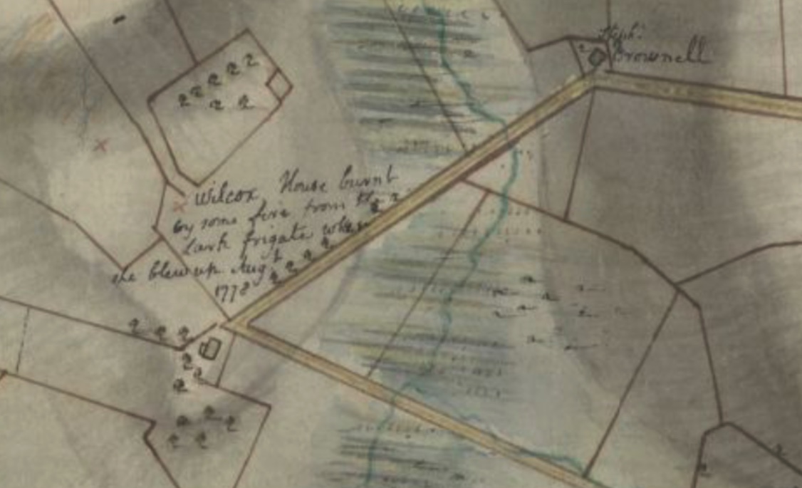
This map shows the Bristol Ferry area. The notes provides the location of a Rebel made fortification. The Bristol Redoubt “was left by the Rebels about 1775, nearly finished.” A note to the north of the Bristol Redoubt tells us houses were destroyed and orchards were cut down between Town Pond and the Bristol Ferry landings. Another orchard was cut down off of Bristol Ferry Road to the south of the ferry landings. William Burden (Borden?), Codington (Coddington) and Earl are three of the farmers mentioned. Widow Westgate’s house was made into a barracks for 50 soldiers. Other farms mentioned are those belonging to George Irish, David Anthony, Stephen Brownell and George Hall.
The Wilcox (Cook Wilcox) “house burnt by some fire from the Lark Frigate when she blew up August 1778.”
As the French fleet was arriving in late July of 1778, the British ordered that their ships would be destroyed rather than be taken by the enemy. The frigates Lark, Cerberus, Orpheus and the Juno were no match for the French ships coming in. The Lark’s Captain Smith ran his ship aground and set her on fire. The Lark’s 76 barrels of gunpowder exploded and ignited the Wilcox home. Flaming debris landed as far away as three miles. In his diary, British engineer Frederick Mackenzie wrote: “It was a most mortifying sight to us, who were Spectators of this conflagration, to see so many fine Frigates destroyed in so short a time, without any loss on the part of the Enemy.”
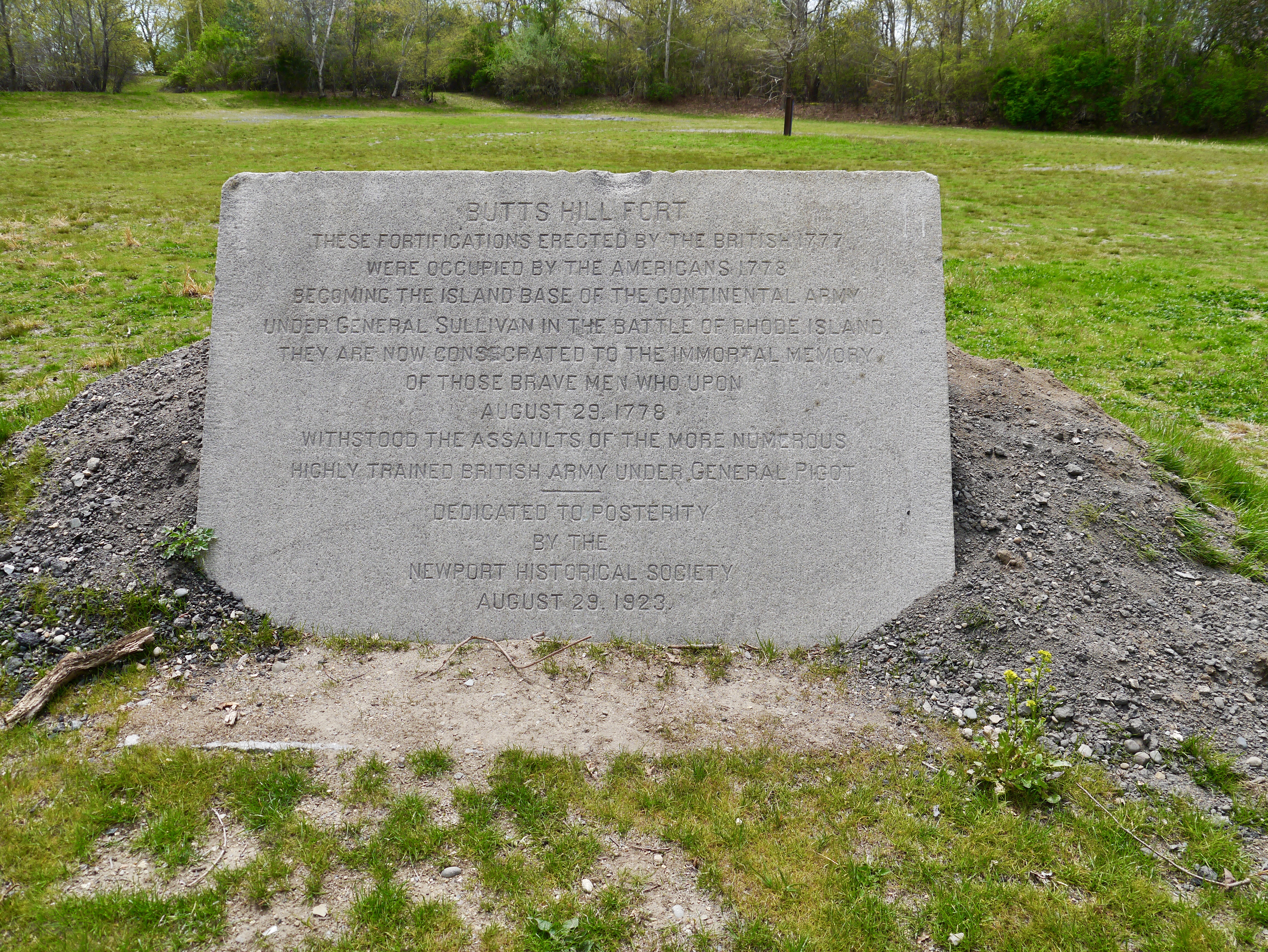
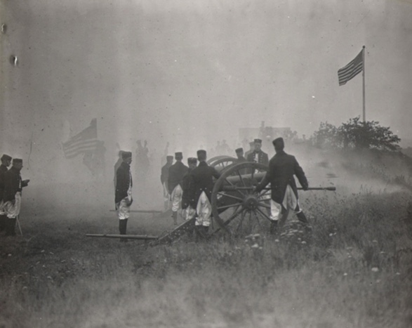
Butts Hill Fort These fortifications erected by the British 1777 were occupied by the Americans 1778 becoming the island base of the Continental Army under General Sullivan in the Battle of Rhode Island. They are consecrated to the immortal memory of those brave men who upon August 29, 1778 withstood the assaults of the more numerous highly trained British Army under General Pigot. Dedicated to posterity by the Newport Historical Society, August 29, 1923.
This memorial stone was dedicated with some fanfare. There were speeches and battle reenactments, marching bands and the blast of cannons. This sacred piece of land was saved from being a housing development by the then President of the Newport Historical Society, Rev. Roderick Terry. He personally bought the property (and Fort Barton as well) and gave them to the Society. This gift came with some restrictions:
*The Newport Historical Society and its successors were to forever “preserve, keep and maintain” the property as a monument to those who fought in the Revolutionary War. *That the property will always keep the name “Butts Hill Fort.” *That the property should never be used for monetary gain.
Dedication 1923
The Newport Historical Society could not maintain the fort. In 1968 the land was transferred to the State and on to the Town of Portsmouth. Terry’s restrictions on the property remain today as the responsibility of the town of Portsmouth.
The Butts Hill Fort Restoration Committee aims to fulfill Rev. Terry’s mandate to preserve, keep and maintain the property as a monument to those who fought in the Revolutionary War. The Committee is working on a land management plan to restore the fort and create an area of walking trails and informational signage.
As the anniversaries of the American Revolution and Battle of Rhode Island draw near, the task of “preserving” the fort and ensuring that it is a monument to those who fought in the Revolutionary War becomes even more vital.
A continuation of a tour of Butts Hill Fort : Stop 5: At the parade grounds
In December of 1779 the British finally departed from Aquidneck Island. The Americans regained possession of Butts Hill. The French arrived on Aquidneck Island on July 11, 1780 and the island was again occupied by troops. In October of 1780 one American militiaman would report in a letter:
“…there are about 7500 Men on the Island at the Several ports, 5000 of which are French, at Newport, 2000 Three Months Men, at this place and 500 Continentals, under Col. Greene of this state.”
The allied French and American forces felt secure, but they continued to prepare to defend the island. On Butts Hill there were American troops assigned to support the work of the French troops in restoring the fortifications. Through the summer and fall of 1780, Butts Hill was actively being enclosed and made into a fort by the Americans and their French allies. This is the fort shape we recognize today.
Rochambeau Map 1780
We get a glimpse of their work through the Orderly Books of Ebenezer Thayer and John Jacobs. An orderly book is a record of the day to day activities of a unit. Thayer recorded the activities of a troop assigned to support the Expedition Pariculiere, the French Expeditionary Army under the command of Rochambeau. Their service was from August 16th to November 28, 1780. Other orderly books and some letters written from the camp give us an idea of life in the camp. That life was not easy.
The September 9th entry by Thayer shows they were assigned six men to a tent with a cook for each group of six. Later entries show that the kitchens had to be moved higher to prevent the smoke from filling the tents. A later entry tells us that the guard consisted of sixty rank and file soldiers. There were also sentinels around the encampment – 2 in front and one in the rear. This is kept up day and night. This day’s entry also includes concern about the filth around the camp that could be detrimental to the soldiers’ health.
They were not equipped well. An entry expresses concerns that there were not enough axes. One of the “fatigue duties” (labor duties that don’t require arms) was gathering wood. The axes would have been essential to chopping wood. Wood on Aquidneck Island was so scarce they had to go to Freetown, Massachusetts to obtain firewood.
Soldiers were hungry and stole from nearby homes and they were disciplines for that. The officers had a hard time securing enough food to last a day so that they might be fit for duty. In a October 10, 1780 letter to friends in Boston, Major May of the Boston Regiment shares his experience.
“We have but 21 days to tarry here, but famine seems to stare us in the face. I could give you particulars, but I never was fond of telling all. It may suffice to say, that we have one day’s rations of Indian meal on hand, no meat, no wood, no sauce etc. Before I go any further I must tell you I have been, even now, sick with a stupefying cold. ..I hope I may be returned to you all again, in health and safety.”
One group that were assured of good provisions were those actively helping the French masons. “There are four men to be detached from the brigade to attend constantly on the French Masons until the stone pillows (pillars?) of the Fort are completed and two masons detached to assist the French Masons until the works are finished and for their service they shall receive half a pint of rum a day when in the store.” Their provisions are ready for them so that they can complete the Fort works in a timely manner.
Fort building was hard work. One entry records that the American wagons are bringing loads of stone to the works at Butts Hill Fort. They are building a “sally port” which is a secure, controlled entry way to an enclosure like a fort. All tools must be returned to the engineer. Members of the Black Regiment continued the “works” at Butts Hill Fort once the Massachusetts militias departed.
We think of the Black Regiment’s valor during the Battle of Rhode Island, but I am discovering more ties between the First Rhode Island Regiment (commanded by Col. Christopher Greene) and the construction of the fort at Butts Hill. This was a time of transition for the soldiers of the Black Regiment and it is not always easy to follow them as they were absorbed into other units and divided for assignments.
First, I need to provide some background. When the British voluntarily left Aquidneck Island in October of 1779, the Americans came back to find the Island decimated. The First Rhode Island Regiment joined the Second Rhode Island Regiment in Newport on November 3, 1779. After the British Occupation, supplies of food and wood were dangerously low in Newport. They were sent to winter in Providence and East Greenwich. In early February of 1780 one report had the regiment at about 143 privates. They had orders to march for New York, but the arrival of the French on Aquidneck Island changed the plans.
On July 10, 1780 the French fleet and army arrived in Newport. General Heath of the American Army acted as Washington’s liaison, but on July 25th he was joined by Major General Lafayette. Five thousand French soldiers set up camp in Newport. Although a small number of the Black Regiment soldiers were sent as guards to Providence, by the end of July the remainder of Col. Christopher Greene’s men and the Rhode Island Six Months Continental Battalion encamped in Portsmouth. They performed guard duty at Butts Hill, Howland’s Ferry, and Bristol Ferry.
The Massachusetts Militia Orderly books show that Greene’s men were transported to East Greenwich to prepare for a march west with the American Army. However, the activity of the Royal Navy caused alarm and American General Heath ordered Greene’s troop to return to the island. Greene was disappointed but made a request in a letter to George Washington. The letter, dated October 14, 1780, gives us a further link between the Black Regiment and Butts Hill Fort.
“When Gen. Heath left this post, the command of the American Troops devolved on me. The difficulty of getting supplies of provisions has been such that we have been almost entirely without. This has greatly retarded the completion of the very important work at Butt’s Hill, where the three militia from the Massachusetts State have been employed. Their time of service expires the first of next month. I am confident they will not be able to put the fort in a defendable state by that time. Should your Excellency not call my Regiment to join the Army. They will undoubtedly be very usefully employed making it so. I wish to know your Excellency’s pleasure as to our staying here or joining the Army. If we stay in this state which part of it to La__ Winter Quarters – as the season is far advanced and the Times of the Six months Service expire the first of January. Perhaps in the short time they have to serve may be useful here as with the Army, though for my own part I ever wish to be with the Army…”
Letter of Col. Christopher Greene to George Washington – 10/14/1780
According to pension petitions, they helped the French soldiers and masons complete the job of re-enforcing the fortifications at Butts Hill. Fifty of their soldiers were detached to help the French move their artillery. After two calls back to Aquidneck Island, they would later join the American Army on the march south and participated in the final battle at Yorktown.
Resources
“They fought bravely, but were unfortunate.” by Daniel Popek was a valuable resource. Its footnotes led me to many important documents.
Letter of Col. Christopher Greene to George Washington, Oct. 14, 1780
Letter of Col. Christopher Greene to Governor William Greene, October 27, 1780