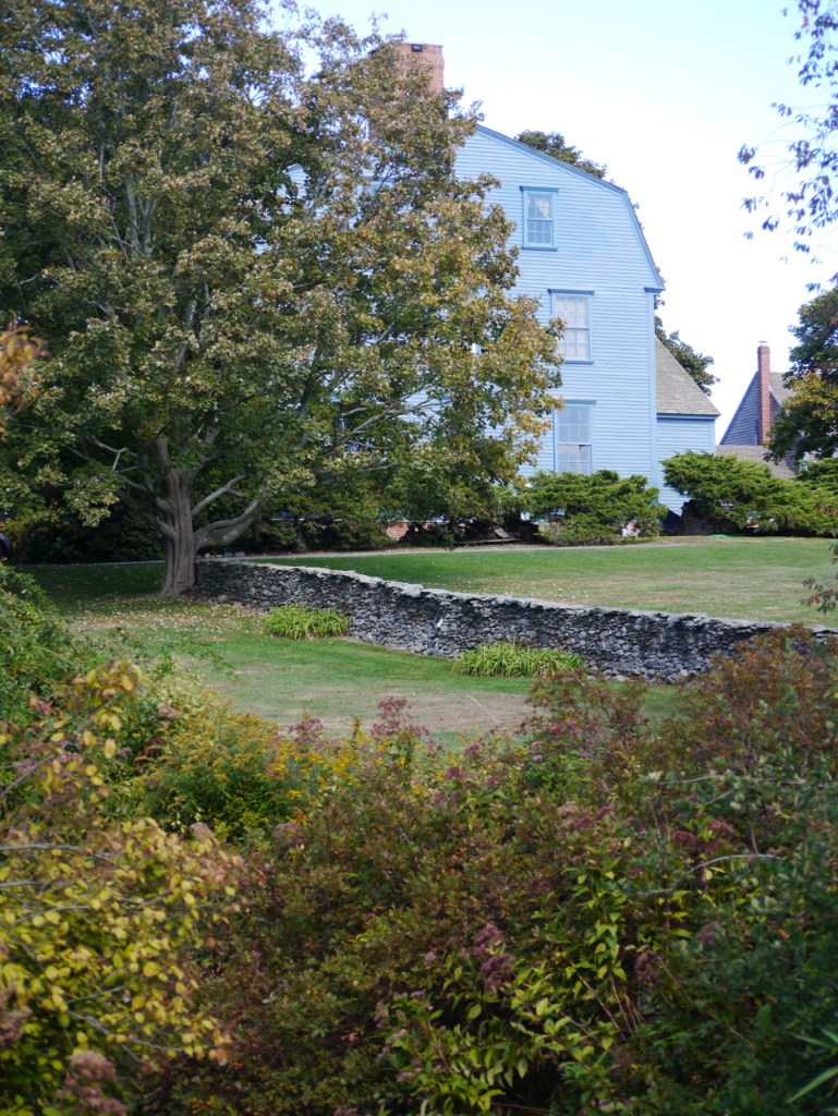
Prescott Farm (Overing House) West Main Road at town line.
At this site, British General Richard Prescott’s was captured in July 1777, Colonial militia, led by Colonel William Barton, made the daring night raid. The site is owned by the Newport Restoration Foundation. Besides the Overing House (1730) it includes relocated Portsmouth colonial homes: The Hicks House (1715) from Bristol Ferry Road and the Sweet Anthony House (1730) from West Main Road.
Vintage image of Overing House
View of house from Prescott Farm
2. Patriots Park West Main Road at split with Route 24.
Memorial to the 1st Rhode Island Regiment, known as the “Black Regiment” located at the junction northbound of Routes 114 and 24. Flagpole commemorates the site where the Black Regiment courageously fought off a Hessian attack, saving the American line, on August 29, 1778 during the Battle of Rhode Island.
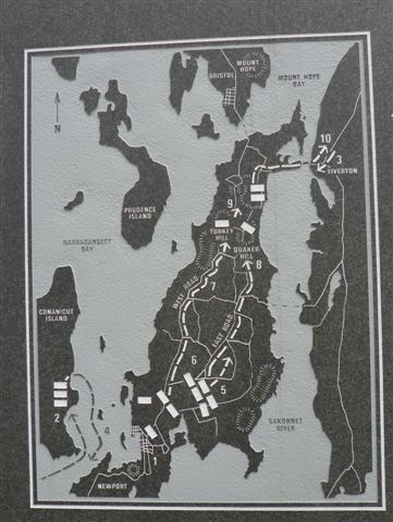
Battle of Rhode Island map at Patriot’s Park
3. Bristol Ferry Town Commons and Mount Hope Park (old ferry landing) End of Bristol Ferry Road at Bayview
This is the site of a town common dating back to 1714. Ferry service started here in 1640. This 1.5 acre space was originally used by farmers and others to keep their livestock and other goods while waiting for the ferry to Bristol. The ferry landing had a British fort during the occupation.
Bristol Ferry Landing 1929
Bristol Ferry Town Common today
4. Stone Bridge area Park Avenue
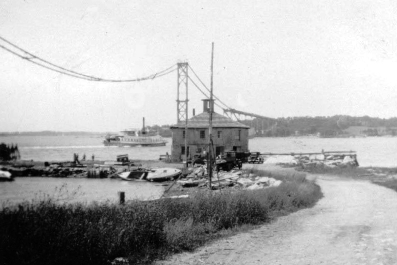
Site of bridges to Tiverton dating back to 1795. Nearby is the location of Howland Ferry to Tiverton which was one of the ways the Patriot forces left Aquidneck Island after the Battle of Rhode Island. The British had a fort here during the Occupation of Aquidneck Island.
Vintage view of Howland Ferry Era
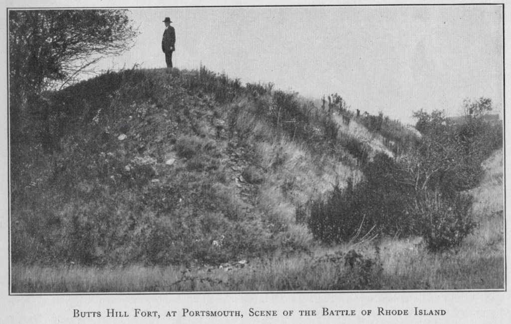
5. Fort Butts Off Sprague Street
In 1776 the Americans built a small battery on Butt’s Hill. The British and Hessians occupied the fort in December of 1776 and enlarged it to hold barracks for 200 men. During the Battle of Rhode Island in August of 1778, the fort was an American strong hold and the whole battlefield could be seen from this position. After the British left, French forces and portions of the Rhode Island First Regiment repaired the fort.
Monument at Buttys Hill Fort today
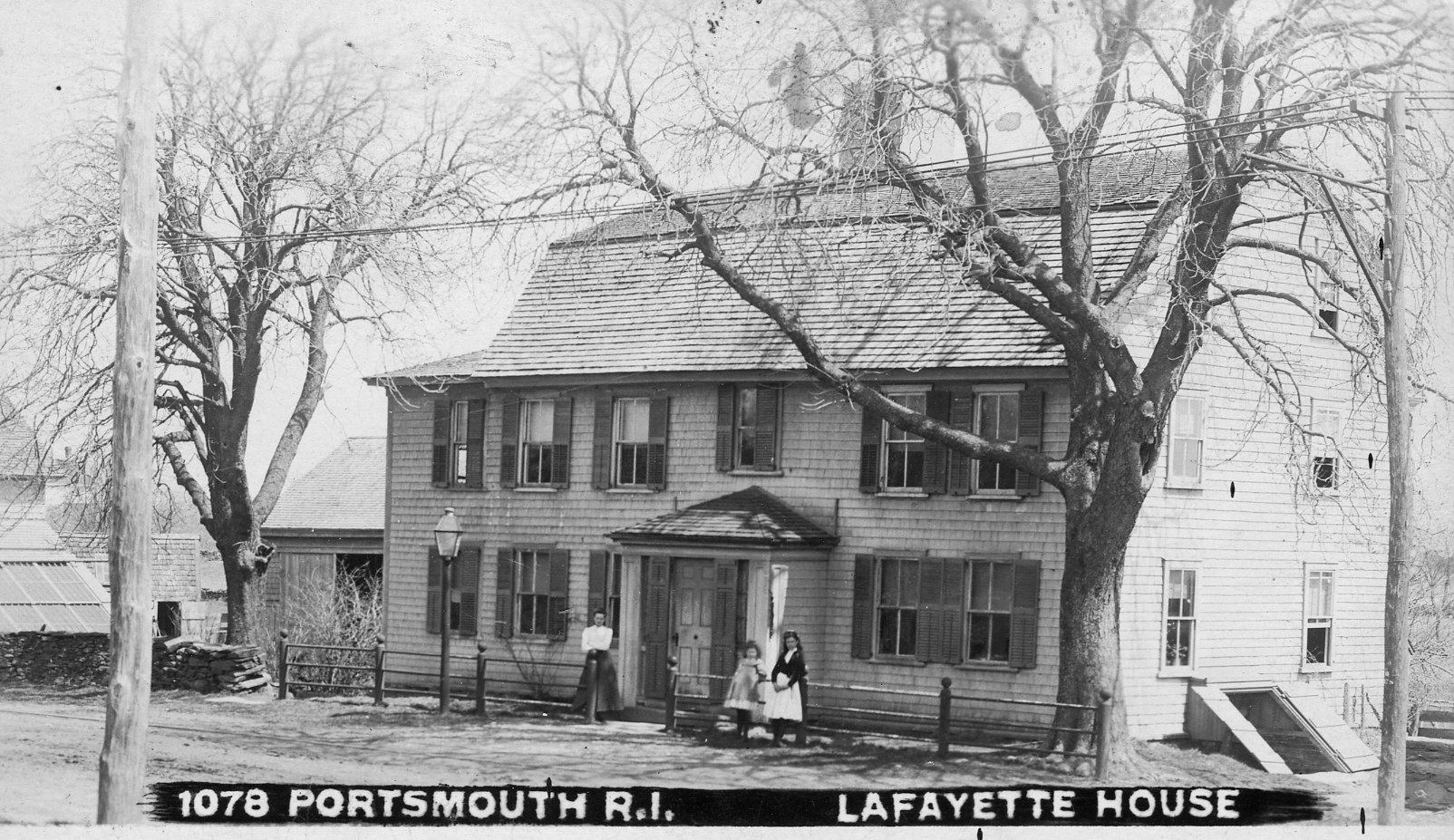
6. Lafayette House 2851 East Main Road
Also known as the Joseph Dennis house (1760), French General Lafayette stayed here just before the Battle of Rhode Island.
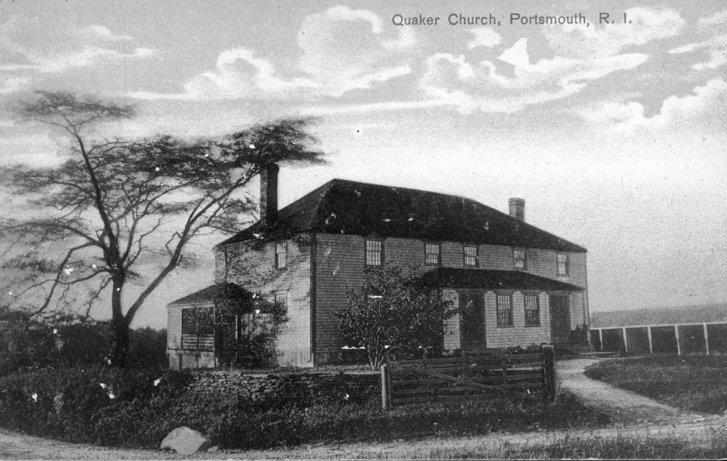
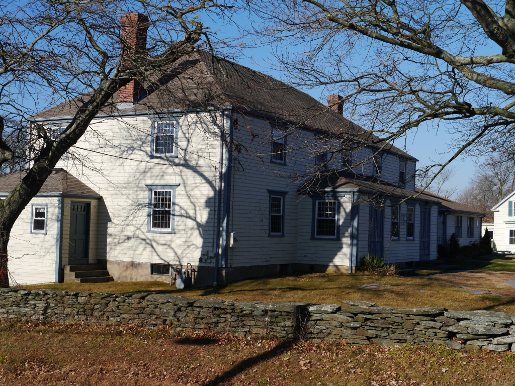
7. Friends Meeting House Middle Road at Hedly St.
The Portsmouth Society of Friends was founded in 1658 and this Meeting House was completed in 1700. It is now known as the Portsmouth Evangelical Friends Church. This building was occupied by the British and was a central part of Quaker Hill action in the Battle of Rhode Island.
Quaker Meeting House circa 1700
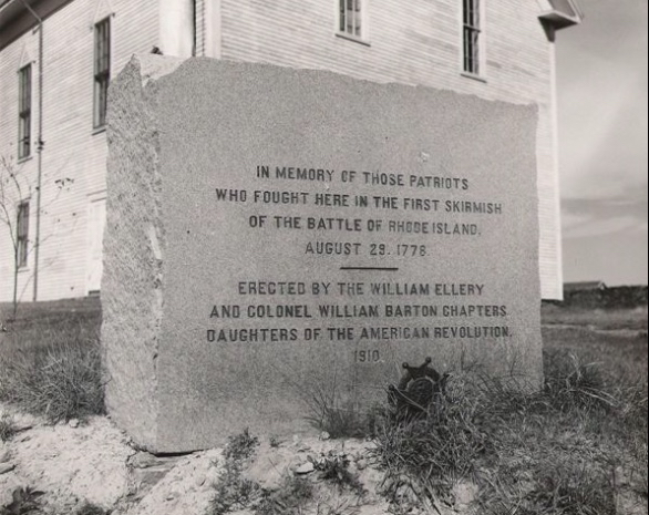
8. Historical Society Museum Corner of East Main Road and Union Street.
The state’s oldest schoolhouse, Southernmost School (1725) is on the grounds of the Portsmouth Historical Society as well as a monument commemorating the first volleys of the Battle of Rhode Island.
Long ago I was asked to research what buildings date from the time of the War for Independence. I put this driving tour together after I had done the research, but it was never used. With the renewed interest in Butts Hill Fort and all things Revolutionary, I’m including it in my blog in hopes it is useful. Please let me know if I need to update information. There is already one house I had to eliminate because it was torn down to make way for a housing development.
Portsmouth Revolutionary Heritage Trail
In the mid 17th century there were two roads laid out – East Main and West Main Roads. Each was a path toward ferries. West Main headed towards the Bristol Ferry and East Main led to the Howland Ferry to Tiverton. Most of the old houses and sites grouped around East or West Main and the roads around the other ferries. There was a cluster of buildings around the way to the Bristol Ferry and on Glen Road towards the Fogland Ferry to Tiverton.
Dating many of the old homes is very difficult. Many homes have a small part of the Revolutionary Era building as part of the house, but much of the home was added on later. Many of the “named homes” bear the names of families who owned the house much after the Revolutionary era.
Beginning at the Middletown Border on West Main Road.
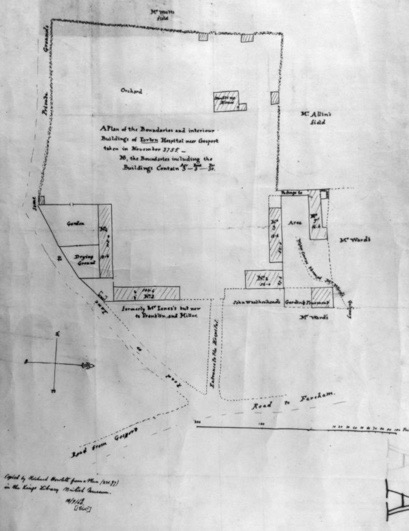
Nichols -Overing House (Prescott Farm)
The Newport Restoration Society which now conserves this property dates this house to 1730. – In July of 1777, an American force of forty men, led by Colonel William Barton, captured General Prescott here. It was one of the boldest and most hazardous enterprises of the American Revolution. General Prescott was later exchanged for the American Major General Charles Lee.
At this site you can also see some Revolutionary era structures which have been relocated to what is called Prescott Farm today.
Guard House: This small gambrel-roofed building was attached to the back of the Nichols–Overing House in 1840. Oral tradition has it located on the site in the 1700s and its frame is certainly 18th century.
The Hicks House: This house dates from around 1715 and was moved from Bristol Ferry Road, Portsmouth to its present location in 1970. It is thought to have been used, in its earliest period, by the ferrymen who operated the boat between Portsmouth and Bristol at the site of the current Mt. Hope Bridge. It is a very simple structure of two rooms and a loft space.
Sweet-Anthony House. Originally located at 855 West Main Road, this house was moved to Prescott Farm in 1970. This broad-gable roofed 1½ story farmhouse came with much original woodwork intact. It is a good example of simple rural architecture, complete with additions which were made in the 18th and 19th centuries.
Proceed up West Main Road past Raytheon. At the crest of the hill on the right is Locust Avenue,
Steven Watson House, 98 Locust. Right side of house dates to about 1760 – main part is 1835. This is a private home.
Heading North on West Main Road,
Farther to the north, on the heights of Turkey Hill, was the Hessian stronghold during the Battle of Rhode Island. This was at the intersection of West Main Road with Hedly Street. There is a northern overlook of the battlefield on Capillary Way (off Hedly St.). As you continue north from Turkey Hill on Rte. 114 (still West Main Road) there is a short section of the original Hessian route to the west.
Henry Hedley House. 234 Hedly Street. 1730. Hedley family farmhouse.: It is set back from the road on Maplewood Farm. Private Home.
Heading North on West Main Road, Cory’s Lane is to the left after Hedly St.
Seth Anthony House is on the grounds of Portsmouth Abbey. Built around 1740. The house, at the end of a long lane behind Portsmouth Abbey School, was in the middle of the Battle of Rhode Island in 1778 and was plundered by Hessian soldiers.
Return to West Main and Travel North
Follow the new highway down the north face of Turkey Hill, and where Rte. 24 begins, swing left to follow Rte. 114. Note the Battle of Rhode Island marker on the left. The monuments reads: “Bloody Run Brook, First Black Militia, R. Island Regt., August 29, 1778. In honor of the first Black slaves and freemen who fought in the Battle of Rhode Island as members of the First Rhode Island Regiment The Black Regiment.”
Continue north on Rte. 114, up LeHigh Hill. As the road curves around to the east, there is a western overlook for the area of heaviest fighting in the Battle of Rhode Island. West Main Road ends at the intersection with Turnpike Avenue (to the south), Bristol Ferry Road (to the north/Rte. 114 continued), and Sprague Street (to the east). Continue straight (east) onto Sprague Street, which skirts the north slope of Butts Hill. Turn right (south) onto Butts Street, go part way up the hill, and park along the side of the road near the water tower. Please be sensitive to the fact that this is a congested residential area. Walk into the fort along the dirt road by the water tower, and enter the center of the park through the gap in the earthwork walls next to the granite marker. From here you can walk around the fort to get a sense of the outlines of the walls.
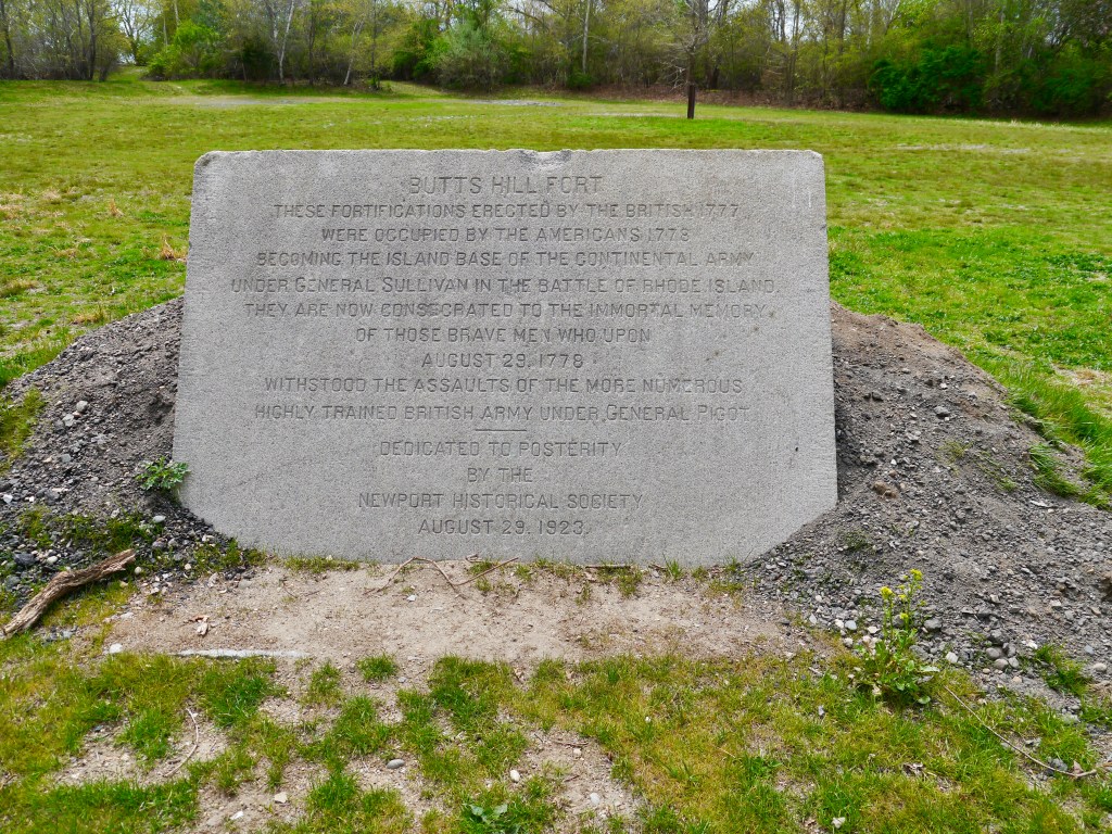
History of Butts Hill Fort
In 1776 the Americans built a small battery on Butts Hill (also called Windmill Hill), the highest ground on north Aquidneck Island. The British and Hessians occupied the fort in December 1776 and later built a barracks nearby for 200 men, which then was connected to the earthwork. Butts Hill Fort is the largest extant Revolutionary War structure in Rhode Island.When the Americans abandoned their unsuccessful Siege of Newport in August 1778, they established their lines around Butts Hill. During the Battle of Rhode Island on August 29-30, the fort was the American stronghold and the whole battlefield could be seen from its heights. The British returned to Butts Hill when the American troops withdrew to the mainland, and in 1780, after the British abandoned Rhode Island, French troops were also there. Following the close of the war, Butts Hill was not congenial for farming, so the earthwork remained virtually intact. In 1909, local preservationists worked to save the earthwork from 200 platted house lots, and Butts Hill Fort opened as a park in 1923. Although the earthwork is now heavily overgrown and there has been some erosion, the fort’s dramatic features are clearly identifiable. The open area in the center, once graded for playing fields, is now very muddy. The access road and walking paths around the earthwork’s eastern perimeter are also rough and muddy. Despite intermittent attempts to manage the park, it is subject to vandalism. For instance, there is evidence of illegal artifact-hunting, the early signage has disappeared, and the large granite marker at the entrance is intermittently “tagged” (paint vandalism). In partnership with the Town of Portsmouth, the Butts Hill Fort Committee plans for Butts Hill Fort include proper parking away from the residential area, removal of the intrusive vegetation, trail improvement, creation of viewscapes, installation of signage, development of an interpretive center, and a continuing presence to deter further damage to Rhode Island’s most important Revolutionary War site.
Return West on Sprague Street to West Main Road. Turn left at Turnpike Ave/Bristol Ferry Road
Brownell Ashley Grant House 24 Bristol Ferry Road. Probably 1750. Moved from Melville area.
Gifford Inn. 531 Bristol Ferry Road. Gifford House c. 1750; Portsmouth Town Records show that in 1775 David Gifford had a license for an inn. David Anthony and Benjamin Hall were listed as the “gentlemen” for the public house. David Gifford was active in the local militia during the Revolution.
Proceeding north on Bristol Ferry Road to the water.
Bristol Ferry area. This is a historic landscape/seascape even though the ferry landing is no longer there. A boat service, conveying passengers across the narrows between Portsmouth and Bristol was established as early as 1658. For many years the ferry was known by the names of the owners–Tripp’s Ferry and Borden’s Ferry–until just before the Revolution, when the name “Bristol Ferry” was applied to the ferries on both sides. During the Revolutionary War, a battery was located near the ferry landing. At first, boats were propelled by oars and sails to transport passengers and freight.
Heading South on Bristol Ferry Road and Turning left on Boyd’s Lane
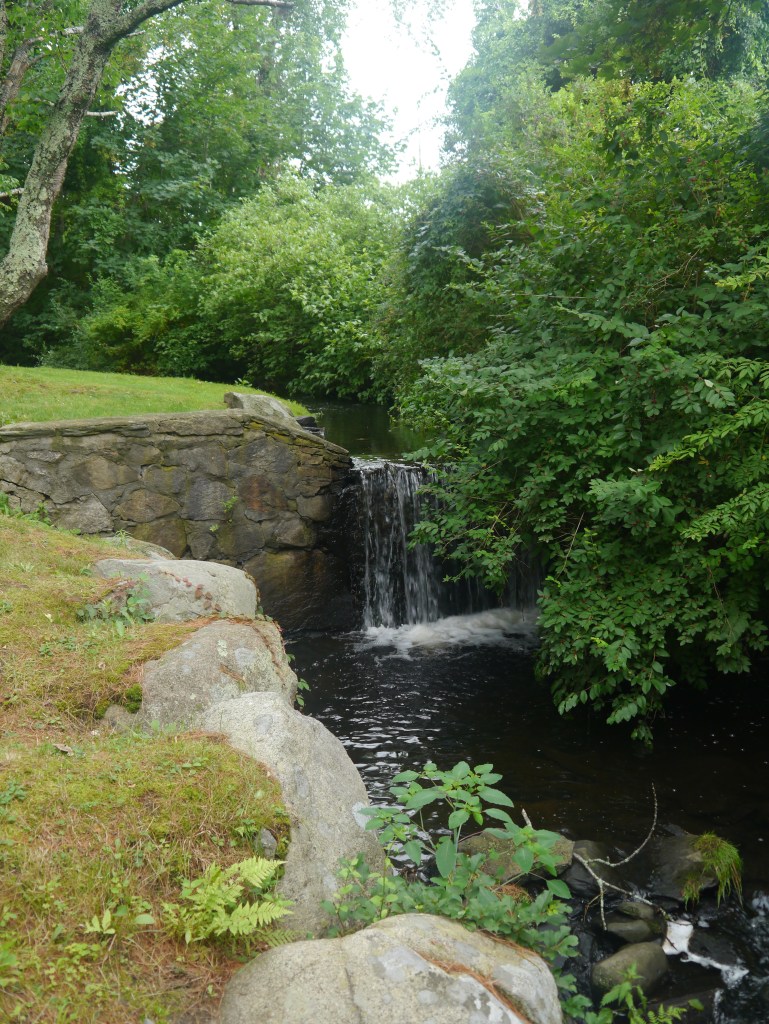
Founder’s Brook: A bronze tablet set into a “puddingstone” boulder near Founder’s Brook marks the site of the initial settlement of Portsmouth in 1638 and bears the words of the original Portsmouth Compact of government and the names of the twenty-three
signers. In the vicinity of the site were the first houses of Portsmouth. Later, the town center was moved to Newtown and gradually .the original settlement was abandoned.
Today, there is no trace of it.
Continue South on Boyd’s Lane to Park Avenue. Continue Left on Park Avenue to Point Street.
The Stone Bridge site is another historic seascape/landsape. The stoneworks on the site are the remains of what was the most important bridge in Portsmouth for more than 135 years. Near this site, at a narrow part of the Sakonnet River, a ferry was established in 1640. Howland’s Ferry–also known as Pocasset Ferry, Sanford’s Ferry and Wanton’s Ferry. This ferry to Tiverton was the first in Rhode Island. Ferry service continued until about 1794, when the Rhode Island Legislature authorized the Rhode Island Bridge Company to build a bridge at Howland’s Ferry. Near the west end of the bridge is the site of a Revolutionary War battery in 1777.
Returning west on Park Avenue.
Elm Farm. Anthony Homestead 48 Park Avenue: Elm Farm was once the residence of Henry C. Anthony, a seed grower and vegetable raiser, who sold to markets in the United States and Canada.
East Main Road and Heading South.
Wilkey House: 3146 East Main. Listed as 1700. This home was in the Cory Family for years.
Samuel Wilbur House: 3064 East Main Road- possibly 1710. Used as schoolhouse.
Andrew Chase House: c. 1750; 2870 East Main Road.
Joseph Dennis House: c. 1760; 2851 East Main Road. General Lafayette stayed here just before the battle of Rhode Island 1778.
Isaac Hathaway House: 2256 East Main Road. 1755. Anthony family.
Heading South Up Quaker Hill on East Main
Friends Meeting House c. 1700: A 2-story, hip-roof structure, with a large enclosed entry portico and a lean-to addition at the south side. There is a 1/2-acre cemetery behind. During the Revolutionary War it was used as a barracks and as a magazine by American and Hessian soldiers.
Quaker Hill: Site of important British fortifications during the Revolution.
Turning left off East Main to Fairview Lane
Robert Sherman House. 168 Fairview Lane. Maybe 1710 or 1720. Listed by town as 1670.
Heading West on Fairview and turning left on Middle Road.
Rathbone House 697 Middle Road. Built around 1750.
Backtracking to Fairview and turning South on East Main Road.
Souza House (Gardner T. Sherman) 1314 East Main. Probably 1771. Occupied by solders duirng Revolutionary War. Very modified.
Sisson Phillips House 1236 East Main Road. Oldest house in Portsmouth dating from the mid 17th century.
Almy House. 1016 East Main. 1750. Commercial site today.
Turning Left on Glen Road
Glen Road itself dates from 1738 when a ferry the the Fogland area of Tiverton operated at the foot of the Road. Glen Road now stops short of that ferry landing, but you can still view the Fogland area. In this area Hessian troops had earthwork redoubts to guard against a surprise attack of American troops crossing from Tiverton.
Turn Left onto Glen Farm Road
Mill Gatehouse: 96 Glen Farm Road. This house was on land purchased by Joseph Cundall in 1745. This house was probably built after that date. When the Cundall estate was later divided, this building was called the Gate House and probably served as the gatehouse to the Glen Mills. Cundall was a cloth worker who purchased a fulling mill on the banks of the Glen stream. This was a traditional site for a water powered mill and many mill structures were raised on the stone foundations. The mill you see today on the left side of Glen Farm Road is a more modern structure built to support Glen Farm a hundred years ago, but the foundations date back to colonial days.
Turn Oppose the Mill and turn around in the Glen Farm barn parking area. Backtrack north on Glen Farm Road and then turn left and take Glen Road back to East Main Road.
Proceeding South on East Main Road.
Southermost School 1725, a small, 1-story structure. In about 1800, it was moved from its original location on Union Street to the corner of Union Street and East Main Road and its stone chimney replaced by a brick chimney. In 1952, it was given to the Portsmouth Historical Society, moved to this site and restored in 1969-1970. It is one of the oldest one room schools in the United States.
In front of the Union Meetinghouse, at the corner of Union Street and East Main Road, -is a granite marker indicating the site of one of the first skirmishes between British and American forces in the Battle of Rhode Island on August 29, 1778.
Turn West on Union Street.
Almy/Hall House 559 Union Rear part built 1720. Front 1780. Lakeside, Lawton-Aimy-Hall, Farm c. 1690-1700, 1790-1800; A central entry in a 5-bay’ facade, in front, was added to a c. 169O-i700, 21/2-story, gambrel-roof structure at the rear. There are several wood-shingle 18th-century outbuildings and other 19th- and 20th-century structures on the 40-acre farm,which is surrounded and divided by dry-stone wails. The Lawton-Almy burying ground is on the property. The farm was in the Lawton and Almy families until 1938.
Head West on Union Street to West Main Road.
The Portsmouth Revolutionary Heritage Trail ends back at the Middletown border.
Sources:
Garman, James. Historic Houses of Portsmouth, Rhode Island, 1976.
Rhode Island Historical Preservation Commission. Historic and Architectural Resources of Portsmouth, Rhode Island: A Prelimary Report, 1979.
Vision Tax Appraisal Field Notes for Portsmouth RI.
Southermost School
Vintage Image of Prescott House (Overing House)
Around the Portsmouth Revolutionary Heritage Trail
Founder’s Brook is one of those touchstones where we come in contact with Portsmouth’s past. As I walked by the brook yesterday morning, I was aware that this site might have been lost to us without the effort of local people to preserve it.
In the early days of the town this site served as the “Watering Place.” It was a center of activity for the small community of settlers who stayed in Portsmouth in 1639 instead of moving south to the Newport area. A spring here provided drinking water, a location for washing (both animals and clothing) and a central location around which the house lots of the town were laid out. As the townspeople abandoned the idea of house lots in a village and migrated to homes on their larger farm lots, the area lost importance. The small lots here were absorbed into bigger farms.
It took the celebration of Rhode Island’s tricentennial in 1936 and Portsmouth’s tricentennial in 1938 to bring this location back into focus. Sometime after 1910 the Town of Portsmouth acquired the strip of land along the brook. The tricentennial organizers recognized the importance of the location and bought a chunk of land adjacent to the brook to serve as a central location to honor the town founders. Celebrations were held, a plaque honoring the Portsmouth Compact was placed on the puddingstone rock, and members of founding families added stepping stone rocks leading to the area. Founders’ Brook was saved as a treasured spot.
Founders’ Brook needed to be saved once again. In 1960 the state planned to construct a cloverleaf for Route 24 which would have obliterated Founders’ Brook. This time it was the Portsmouth Historical Society and the Route 138 business association that pressured the State Department of Public Works to make the changes to preserve the site.
With the celebration of Portsmouth’s 350th Anniversary, new efforts came to preserve and highlight the site. Memorial stones were added, new signage and a parking lot made it easier for visitors, and special events were held.
Preserving this beautiful site took vigilance, effort and passion. Hopefully we have the vigilance, effort and passion to preserve other historic landscapes in our town. Preserving Butts Hill Fort is another effort that will take vigilance and passion. We are richer as a community when we have these historic landscapes to remind us of our past.
Portsmouth men who fought in the War for Independence risked losing their lives and sustaining serious injuries. They also risked imprisonment if they were captured and that is the story of Enoch Butts and his fellow seamen from the Swallow. I came across Enoch’s story in an old Butts family genealogy, but I wanted to know more about what happened to him and those who suffered with him.
Enoch Butts was born in October 17, 1762 in Portsmouth, Rhode Island. His father was named Enoch Butts as well and in 1767 served as a Deputy from Portsmouth to the General Assembly of the Colony of Rhode Island. His grandfather, John Butts, was in the shipping business and owned a number of vessels before the war. When Rhode Island went to war, It may have been natural for a teenage Enoch to become a seaman on a Rhode Island privateer. Enoch’s older brother Coggeshall Butts (named after his mother’s side of the family) served in the Rhode Island Navy as well.
In searching for military service records, I found Enoch’s name on a list of “prisoners confined in Forton Prison near Portsmouth in England, belonging to this station November 29, 1778. R.I.” The listing of prisoners goes on to say: “Matthew Cogshall and Enoch Butts had made their escape.” Enoch is listed as being from the American privateer Swallow.
How did Enoch become a prisoner? A description of the Swallow gives us more information. The Swallow was an armed sloop – a Rhode Island privateer sloop. She had 6 cannons. She was commissioned in July of 1777 and John Murphy was listed as Commander. First Lieutenant David Gray was an officer.
“Swallow sailed from Acoaxet (near Dartmouth), Massachusetts, probably in August 1777, bound for Cape François, Saint-Domingue with a cargo of fish, oil and lumber. On 12 September 1777, some twenty-four miles northeast of Turks Island., Swallow was sighted, at 0700, by HM Frigate. Aeolus (Captain Christopher Atkins). A brief chase began, involving much gunfire from Aeolus. Murphy threw his guns overboard to escape, but Swallow surrendered at 1145. Murphy and his crew, totaling twenty-eight men, were taken in to Jamaica. … Murphy and the officers and most of the crew were sent to England, nineteen being committed to Forton Prison on 23 January 1778.” * The prisoners were charged with treason and did not fall under the usual rules for prisoners of war.
Now Enoch Butts was a prisoner in England. What were the conditions at Forton Prison? There are some records of American concern for the prisoners and Benjamin Franklin sent emissaries to look into their situation. John Thornton visited Forton Gaol between December 28 and 30. In his memorandum to the American Commissioners he stated that on the first day he had “to bribe the Invalid centries to permit [me] to speak to the prisoners”
Thornton writes: “There is not the least distinction made between the Officers and common Sailors, and the Prison having no glazed windows, they can not have any light without having the Northern and Westerly Winds, their provisions are but scanty at best … There are now in the Infirmary 20, and few days ago 27 in the black hole … the 27 were confined on 2d December and till lately were not let out at all … these men have only the half allowance of provisions. **
Lack of clothing was one of the great concerns and most of the prisoners were half naked in the winter’s cold.
There were 119 prisoners at Forton Gaol at the time; he implied that similar conditions existed for the 289 American prisoners at the Mill Gaol. The Reverend Thomas Wren of Portsmouth was a member of the British relief committee. Throughout the Revolution, Wren helped the prisoners and even protected those who escaped.
Franklin tried to get a prisoner exchange, but that didn’t come to pass. The prisoners, Enoch Butts among them, were not about to stay and wait for diplomatic negotiations. Forton was known for its prison breaks. They dug tunnels, bribed guards, pretended to be ill so they could get to the infirmary where there was less security. Once out they had to worry about the Englishmen looking for the five pounds they would get to return a prisoner to jail. If they were lucky enough to get away, a man named Thomas Digges had set up safe houses and provided escaped prisoners with clothing, food and money to make the trip to France and safety.
Besides Enoch Butts, Mathew Cogshall and a number of Rhode Island Swallow crew members are listed at Forton prison: George Smith, Benjamin Hicks, David Gray, James Two, Robert Wilcocks. Philip Corey.
Enoch Butts, Jr. made it back to Rhode Island. Census records list Enoch and his brother Coggeshall in the Bristol Warren area. Enoch died in Warren in 1823,
Sources:
*https://awiatsea.com American War of Independence – At Sea.
In general, the Portsmouth residents during the Occupation were farmers, Quakers and over 90% white. Some Portsmouth residents held slaves, but they were beginning to release them from bondage.
Farmers
Portsmouth was always a farming community. Portsmouth farmers fed the more cosmopolitan port town of Newport. Most of those who suffered with the British Occupation were farmers. Portsmouth men and women worked in other trades as well. Millers and blacksmiths supported the needs of the farms. Others were involved in the hospitality trade as tavern keepers, innkeepers, shop keepers and ferry operators around the routes to the ferries. The road to the Bristol Ferry was perhaps the most commercial part of Portsmouth. Population was centered around the other ferry routes of Glen Road for Fogland Ferry and Howland’s Ferry for Tiverton. Once the ferries were stopped, those relying on travelers for their income lost their business
During the Occupation, many of Portsmouth’s farms were damaged. The Occupation was harsh and civilians were killed and injured. Not even children were safe. In 1776 a fourteen-year-old boy, Darius Chase, was killed when the British destroyed his family farm. British soldiers were quartered in farmhouses throughout the island. In the early days, families were allowed to leave the island with some of their possessions, but many who had property to defend stayed and endured the hardships. Portsmouth lost about 10% of its population. The cattle and sheep had been ordered off the island so they couldn’t be taken by the enemy for food. What livestock remained on the farms was confiscated to feed the British and Hessian forces. As I mentioned in an earlier blog, the British chopped down most of the trees on Aquidneck Island and burned many houses. They also burned fencing, wooden tools and wooden vehicles like wagons. It was almost impossible for the farmers to go through the process of planting and reaping. The citizens were given an opportunity to help feed themselves. They could keep one gun to hunt birds and they could keep a boat for fishing. During most of the Occupation the British were particularly careful not to damage the mills on the island that ground corn because the corn meal fed the occupation soldiers as well.
Quakers
Quaker Meeting House
circa 1700
A majority of Portsmouth residents were Quakers. Their community centered around the Friends Meetinghouse on Quaker Hill and that building still exists today.
British soldier Frederick Mackenzie wrote in his diary:
Sept 15, 1777 – “In consequence of the General’s summons to the Inhabitants of the township of Portsmouth, to assemble in order to be employed to work on the Redouts, 17 only appeared this morning at the place appointed. The Majority of the Inhabitants being Quakers, they informed the General that it was contrary to their principles to assist, in any manner in matters of War, and that therefor they could not appear. They even refuse to be employed in constructing Barracks for the accommodations of the troops.”
Portsmouth’s Quakers had difficulties with helping the Rebels as well. Captain Jonathan Brownell, a Quaker, raised and organized a Portsmouth troop for the defense of the Island. That troop marched off to the Battle of Bunker Hill. Brownell, a Quaker, was dismissed from the Society of Friends. * A Quaker publication states that after he returned to Rhode Island at Providence, he contracted smallpox and to pay off his bills he was a substitute soldier for famed Quaker Moses Brown.
White
The census records help us understand who the people of Portsmouth were as a whole. Whites made up to 90.5% of the town residents in 1774 and 93.5% in 1782. In 2020 the white population is about 95%. There may have been more slaves on some of the gentlemen farms of Newport merchants in Portsmouth. Samuel Elam, who dressed in simple Quaker garb despite his rich lifestyle, is such an example. His Portsmouth estate was named “Vaucluse” and it was situated off of Wapping Road. This was no rustic rural retreat. Elam had enlarged the house to resemble a temple and he developed elaborate gardens on the grounds. One French visitor described Elam as “the only farmer in the island who does not personally labour upon his own ground.” ** He would be in need of workers for his estate. In most cases one or two slaves were owned.
Elam and other Portsmouth Quakers were finding a conflict between their faith and their slaveholding traditions. In earlier days Quakers could justify their slaveholding by saying they treated them well and educated them. Especially after the American Revolution, Quaker leaders were preaching that ownership of slaves contradicted their fundamental idea of equality of all human beings. In 1774 Quakers were told to give up their slaves or leave the Society of Friends. Portsmouth Quakers began to free their slaves.
Among Portsmouth citizens who freed their slaves for religious reasons were William Anthony (1 slave 1775), Thomas Brownell (1 slave 1775), James Coggeshall (3 slaves 1775), Cornell Walter (2 slaves, 1775). Weston Hicks (1 slave 1775), Isaac Lawton (1 slave 1775), James Sisson (3 slaves, 1775).
Blacks and Native Americans are among those who fought on the Rebel side. Among the Portsmouth enlistees in the war was Thomas Collins, age seventeen. He was listed as an Indian born in Narragansett. The records show he enlisted in July of 1780 as part of the Rhode Island Six Months Continental Battalion. I’m not sure if he was a Portsmouth resident. Perhaps, like Captain Brownell he was substituting for someone else. Portsmouth was supposed to send seven soldiers and two among them were black. Joshua Dick (age 17) born in Portsmouth, is listed as a “negro”. In April 1779 he joined Ensign Benjamin Wilcox’s Company as a Private. He was discharged early in 1780. Bristor Peck is also listed as a soldier from Portsmouth. He was in born Guinea and is listed as a “Negro.” Some sources show him in Bristol.***
Native Americans and Blacks are listed among those of military age and in Portsmouth they did serve.
1774 Census: 343 white males above 16 years old.
341 white males under 16 years old,
400 white females above 16 285 white females under 16,
1,369 whites (90.5%)
21 Indians 1.5 %
122 Blacks 8.0%
1,512 total
1782 Census: 1,265 Whites (93.5%).
7 Indians. .5%,
11 Mulattos 1.0%
67 Blacks 5%
total 1,350
Military age 16-50
261 Whites(94%)
1 Indian .05%
3 Mulatos 1%
13 Blacks 4.5%
total 278
Sources:
Cadbury, Henry J. “Briefer Notices.” Bulletin of Friends’ Historical Association, vol. 28 no. 1, 1939, p. 53-56. Project MUSE muse.jhu.edu/article/469457.
**So Fine a Prospect: Historic New England Gardens.
***Popek, Daniel. They “..fought bravely, but were unfortunate. The True Story of Rhode Island’s Black Regiment. Bloomington, Indiana: Authorhouse, 2015.