Home

Touring Early Portsmouth: Edward West’s West Shore Continued

1 Comment

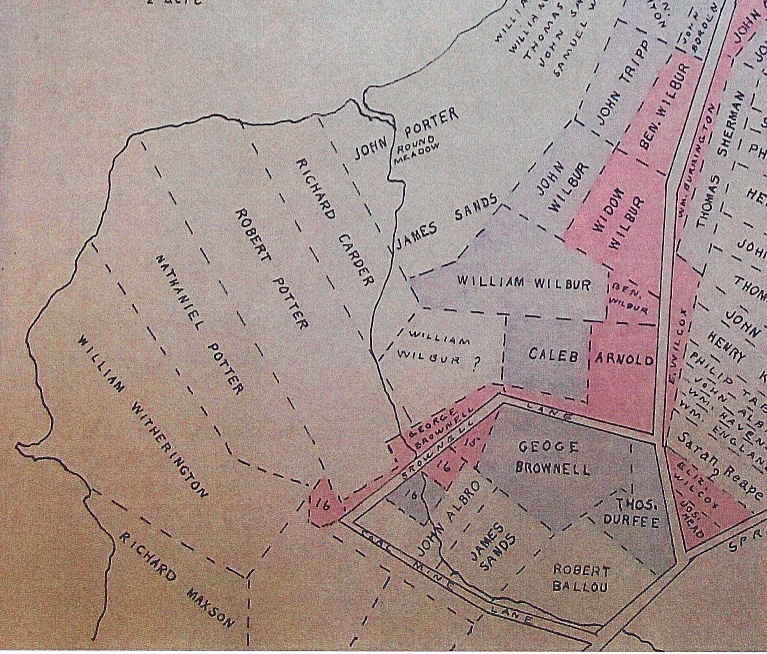
This blog series is based on Portsmouth historian Edward West’s article “The Lands of Portsmouth, RI.” that was published in 1932.  West continues his tour down the West Shore by giving us a glimpse of neighborly friction. We start south of Cory’s Lane with land that had been granted to John Porter.  In 1675 John had given Thomas Shrieve permission to build on a house lot on his property.  Mrs. Shrieve must have had a reputation as a troublemaker because the Town Meeting got involved. “It is consented unto by vote that Thomas Shrieve hath liberty to sett down for the present, upon his wife’s peaceable and good behavior towards her neighbors: until he can more conveniently provide for himself or the town take further orders. Mr. William Baulston, Philip Sherman and Mr. John Briggs are appointed to speak with Shrieve’s wife and William Charles and George Lawton’s wife to give them the best advice and warning for their own peace and the peace of the place.”

In West’s tour we come to the Wading River where George Lawton had been granted 40 acres to build a mill for Mr. Baulston.  George Lawton’s land was mainly on the East side of West Main Road.  Apparently Lawton built a dam on the river, but in 1672 there was concern that it made the bridge there unsafe.  Since Lawton created the dam, the town ordered that George Lawton should make the bridge “sufficient” and that the West Main highway should be restored to the way it was before the damn was built.  Robert Dennis and Jacob Mott were to deal with Lawton on this matter.  Apparently Lawton did not make the repairs because they sent more representatives to him because it “was so dangerous.”

The last property before the Newport (now Middletown) border belonged to Thomas Cornell (100 acres), Edward Hutchinson (100 acres) and Joshua Coggeshall had land that was partly in Portsmouth and partly across the town line.

Touring Early Portsmouth: Along the West Shore to Cory’s Lane

1 Comment

Portsmouth historian Edward West, in his article “The Lands of Portsmouth, R. I., and a Glimpse of Its People,” continues to take his readers from Bristol Ferry south to the West Shore. There was active buying and selling of these land grants.  For example, Samuel Wilbur acquired “Long Meadow” from several grantees.  At the mouth of the brook was another meadow – “Round Meadow” which was the property of John Porter.  The brook was called “First Brook” by the early settlers in 1643, but it became “Little Silver Brook” when it was the property of Robert Ballou.  We know it as Willow Brook and this property was sold to artist Sarah Eddy by the Ballou family.

West Shore South of Bristol Ferry

Going down the highway (known as the “King’s High Road” (we know it as West Main Road), was the property of William Baulston.  This was a large tract of 240 acres and there was a small stream through it.  West thinks it might have been larger in colonial days because it was called Mill River or sometimes Two Mill River.  George Lawton had a mill on this property in 1648.  Also on this river, located nearly down to Freeborn’s Creek, was the mill of James Sands and Samuel Wilbur.  They received a grant for this mill in 1642.  William Freeborn bought the mill in 1655 and the land remained in his family until 1800.  John Tyler also had a mill on this same river.

West Shore to Cory Lane

What we know as Cory’s Lane was laid out in 1683 as “highway 2 rods wide beginning at the sea side on the west side of the Island at the head of William Freeborn’s lot and so to run that breadth to the Common at the head of the land laid out to Ralph Earl, dec.”  In 1717 it was declared a “driftway” down to the water “for the benefit of His Majesties subjects to Pass and repass through, both for cattle, horses, carts, wagons or any carriage or creature whatsoe’er.”

Touring Early Portsmouth: Bristol Ferry area

3 Comments

West Land Grant Map of Bristol Ferry Area

In the 1930s, Portsmouth historian Edward West did some remarkable work with land evidence that benefits us all. Among his works are the Land Grant Maps that tell us where the early settlers were given land. How he worked through all the locations with rods as measurements, I will never know. West tells us that upon founding the town “they immediately made laws governing the size and location of the house lots.” They began recording property in a book. There were times when land transferred without records, so the accuracy of the land evidence may be questionable in some cases. West found some of these properties as he worked with other deeds.  He also wrote an article that appeared in the Rhode Island Historical Society Journal in July of 1932 (The Lands of Portsmouth, R. I., and
a Glimpse of Its People) that gives us a commentary to go with the maps. This series of blogs will be a tour of early Portsmouth using his article and his maps.

The Bristol Ferry Area: Some of the first grants given were in the Bristol Ferry area.  As the town was laid out, Sprague Street was the southernmost border.  West tells us an interesting story.  Just above the Bristol Ferry is the 3 acre lot that Richard Searl sold to Mary Paine.  Mary was a bar-maid at Baulston’s public house.  Searl exchanged his lot for a pint of wine.  He didn’t give Mary a deed, but the town council ratified the sale on the testimony of a witness in 1666.  Mary later married John Tripp and that piece of land became the site of his ferry house.

In 1719 the land to the south of the ferry was ordered to be kept open “for the convenience of the public in importing and transporting horses, cattle, sheep, wood etc.”

The first street to the right was “Stoney Lane.”  It was a short “driftway” (a path used to drive cattle or sheep) between Richard Borden’s property and that of Mistress Harts.  South of that was a lane that led to a “watering place.”  On the map it is called Hawkins Lane for Richard Hawkins and his wife Jane who was a friend of Anne Hutchinson. (Check the reference below to learn more about Jane.) This “watering place” was laid out in 1713 as a public place for the washing of sheep and general water uses.  Also in 1713 Thomas Burton received a piece of land that was known as the “Training Place” before that.  That ground may be where the militia had trained.

Land grants were given out in 1657, 1693 and the last lands were given out in 1713.  By 1713 the commons were laid out, highways were straightened and the town was considered finished as laid out from Sprague Street northward.

Jane Hawkins:  https://portsmouthhistorynotes.com/2017/07/18/founding-mothers-jane-hawkins-accused-of-witchcraft/

West map on Portsmouth Digital Archives:  http://www.portsmouthhistorycenterarchive.org/items/show/144

Preserving Our Walls

Leave a comment

“Why should we care about stone walls?” This question was asked by a Portsmouth elementary student after I had given a presentation on stone walls to a class.  I answered that stone walls are part of our heritage as a farming community and that they are history we can touch.  I am haunted by the question because I hope Portsmouth children and other residents will appreciate the walls and work to preserve or protect our walls.  It may just be that we have so many beautiful walls that our families just don’t appreciate how special our walls are.  Sadly stone walls at Glen Park were among town property vandalized recently.  Thieves have stolen some of the critical capstones on the walls leading to Glen Manor House.  Everyday wear from people sitting or walking on the walls can dislodge stones as well.

There are efforts to preserve our walls.

Our town has an ordinance that seeks to protect the walls that border the town roads.  The Stone Wall Preservation Ordinance of the Town of Portsmouth aims “to protect one of the Town’s important cultural resources, historic stone walls, saving one of the beautiful features of the Town for the people of tomorrow and preserving the rural character of the Town.”

The Aquidneck Island Stone Wall Initiative is a joint project of the Newport County Preservation Society and Preserve Rhode Island. Their vision statement states: ” It is intended to protect and improve Aquidneck Island’s scenic quality by preserving its historic stone walls. Stone walls are visible reminders of the Island’s rural agricultural history and contribute to its sense of place and scenic character.”  With funding from the vanBuren Charitable Trust, the Initiative has restored a wall by the Simmons Farm and it is now working on a wall by the Norman Bird Sanctuary.  It is an effort to call attention to the need to preserve and protect the walls as part of our cultural heritage.

I’m not sure posting “Do not walk on the walls” signs around the athletic fields would work.  Years ago my students were researching the Leonard Brown House and the Camara Sisters (Mary Lou and Gerry) told us a story about the walls.  Mr. Nicholson, the husband of the owner of Glen Farm (Edith Taylor Nicholson) appreciated the walls and wanted the Glen Farm children to stay off of them.  He would pay them a quarter to get down off the wall.  Well, whenever the children saw Mr. Nicholson’s Cadillac coming they would get on the walls just to get their quarters!

Illustration of Children on Glen Walls

All I can do is call attention to the walls with blogs, books and talks.  Perhaps a child (or adult) might appreciate the work involved in building the walls, the beauty of the walls themselves and the farming history the walls represent.

David Shearman Builds a Wall

2 Comments

David Durfee Sherman in Civil War Uniform

One of the special treasures of the Portsmouth Historical Society is the Diary of David Durfee Shearman. Shearman was a “jack of all trades” and one trade he had was building with stone. In September of 1858 he briefly describes how he built a wall in the Bristol Ferry area.

Monday 13 – Went down and built wall for Robert Hicks. I laid the rock as fast as he dragged them, making it hard for me.

Tuesday 14: I built wall- laying out bottom; about 10 rods laid out. Robert had Christopher Dyre to help him had the rocks onto the drag and I placed them as fast as they got them along.

Rock drag

Wed 15: Built wall all day along. I build about three rods a day incline the laying of the bottom.

Saturday 18: I worked for Burrington Hicks, digging out and laying some stones for a foundation to a building banked up around the cellar.

Monday 20th : Buiilt wall for Robert Hicks, fine weather to work.

Tuesday 21: I helped Robert get some rocks for bottom part of the wall. Built wall remainder of the day.

Thursday 23: Went down and helped Robert Hicks dig rocks all day. Had two pairs of oxen-drawing some large ones. They help build the wall up first rate.

Friday 24: Rode father’s mare down and built wall till noon.

Saturday 25: Done a hard days work – finished building the piece of wall building 20 rods in less than six and a half days. I get five shillings a rod for building it. ..Going down to ferry to look at a piece of wall and set a price that I would rebuilt it for. I was pretty tired when I got home – walked nearly 8 miles.

Robert Hicks property

Note: 20 rods is 330 feet!

One estimation is that a shilling at that time was worth 40 cents.  If that is true, Shearman would have made $40 for his almost 7 days work.