Home

Portsmouth Women: Enduring a “Distressed Situation”

Leave a comment

As the memorial stone at Butts Hill Fort reads, it is important for us to honor the “memory of those brave men who” fought in the Battle of Rhode Island”. It is also important for us to remember the Portsmouth women and their families who endured almost three years of British Occupation from December of 1776 to October of 1779. When the Portsmouth Town Council was able to meet again in 1779, the members pleaded with the state to have pity on us because the town was in a “Distressed Situation.” As I research this Revolutionary Era in Portsmouth history, the plight of Portsmouth women and their families was indeed disstressed.

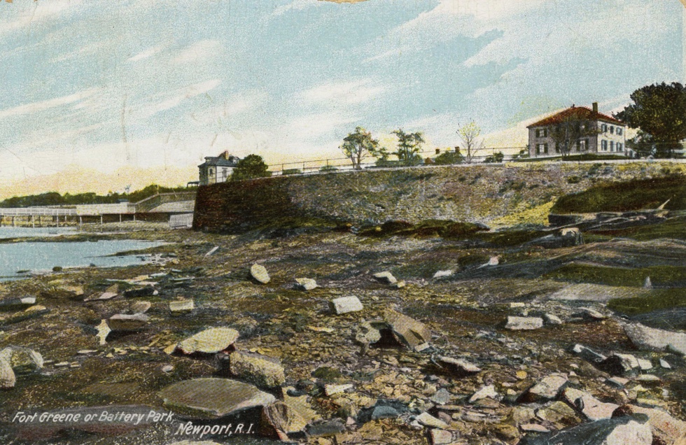
What was Portsmouth like when the British came? The diary of British soldier Frederick Mackenzie provides a rosy picture. “There is a hill about 7 miles from Newport, and on the Eastern side of this Island called Quaker Hill, from there being a Quaker meeting-house on it, from whence there is a very fine view of all the N. part of the Island, and the beautiful bays and inlets, with the distant view of towns, farms, and cultivated lands intermixed with woods, together with the many views of the adjacent waters, contribute to make this, even at this bleak season of the year, the finest, most diversified, and extensive prospect I have seen in America.” This fine prospect did not last long under British military control. Much has been written about Occupied Newport, but the situation in Portsmouth had its own set of troubles. At times citizens were allowed to leave the island, but if you were a Portsmouth farm family you stayed to work and protect your farm. There were many Loyalists in the commercial port of Newport, but the majority of families in Portsmouth leaned towards the Rebel side. Only about ten percent of Portsmouth citizens left the island.

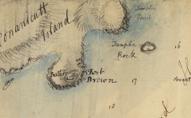
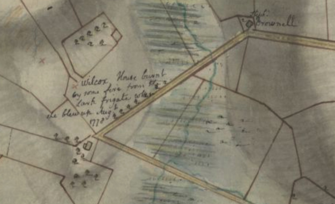
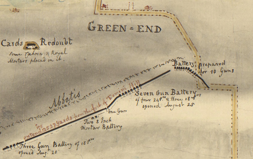
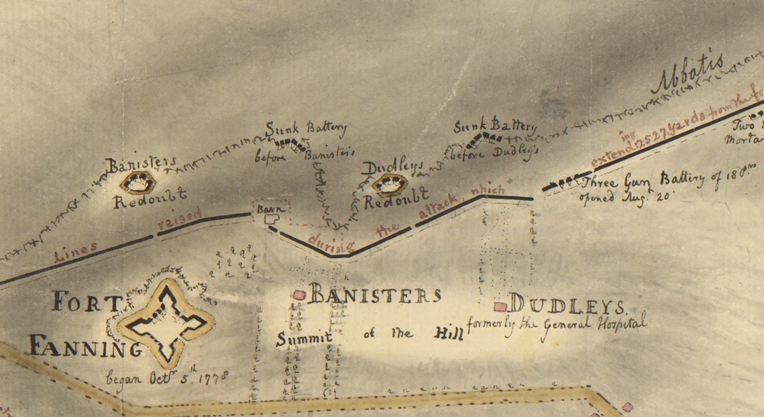
What happened to Portsmouth women and their families when the British arrived? British maps from the Revolutionary Era give us some idea.

  1. Some families lost their homes. For example, the British fortified Bristol Ferry and they tore down homes that blocked their vision of the ferry landing. Some houses were taken over as barracks for troops or as housing for officers and generals.
  2. Almost all families lost their trees and orchards. As time went by just about every tree on the island was cut down for firewood. The families were left in the cold while the British warmed their troops.
  3. Farm families lost their livestock. There were many soldiers to be fed. Mackenzie’s diary says the British left families with a means of feeding themselves. They could keep one gun to hunt birds and they could keep a boat for fishing.
  4. The British took just about every wagon and wooden farm tool. Wooden vehicles were used by the British for carrying loads, and almost anything wooden was burned for fuel.
  5. Women assumed greater responsibility to care for their families. With the exception of Quaker families, almost all Portsmouth men served some time in the American cause. Even those who were on the island during the Occupation were impressed into service by the British to work on fortifications on Butts Hill and elsewhere.
  6. When the British left the island they filled in just about every well – the source of water for families.

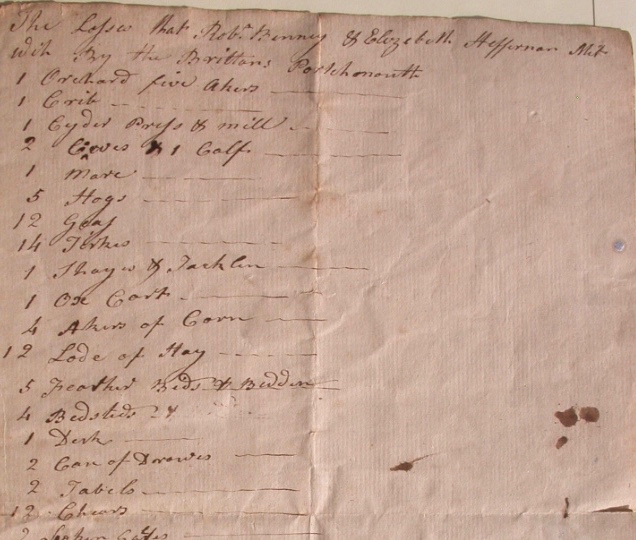
At the withdrawal of British troops in 1779, Portsmouth farm families had a difficult time getting their farms back into operation. Families listed their losses in hopes of getting some reparations. One of these lists is in the collection of the Portsmouth Historical Society. It gives us an idea of how devastating the household losses were. This list shows the losses of Edward Binney and Elizabeth Heffernan – in-laws who lived in a joint household just north of the Friends Meeting House on Quaker Hill.

Among the losses:

Livestock: 2 cows, one calf, 5 hogs, 12 goats, 1 jackass

5 acres of orchards, a cider press and mill, 4 acres of corn, 12 loads of hay,

Farm tools: An ox-cart, 3 hoes, forks, 2 spades

Household goods: desks, beds, drawers, wood cards, kettles, pots, gowns, tablecloths, etc.

It is clear that we should honor the brave Portsmouth women who cared for their families under such difficult circumstances.

Fortified Jamestown: Conanicut Battery and Dumplings

Leave a comment

Conanicut Battery

The Conanicut Battery is a Revolutionary Era fortification that can be seen today on the West side of Beavertail on Jamestown. In preparation of war, the Rhode Island General Assembly ordered the building of the Conanicut Battery in 1776. Originally a crescent-shaped earthwork, it was designed for six to eight heavy cannon and soldiers. When the British invaded Aquidneck Island they also captured Jamestown (Conanicut Island) and held it (basically) from December 1776 to October 1779.

Image by Seth Chiaro

In his diary entry for December 7, 1776, Frederick Mackenzie writes: “…at 12 made the Light House on the S. point of Connonicut Island at the entrance of Rhode Island harbour….and about 1 o’clock that ship (The Experiment with Capt. Wallace) took the lead, and stood up the Western Channel between Connonicut, and the Main(land)… About 2 miles from the Light House, Rebels had a Battery or Redoubt with 4 Embrazures towards the Channel, But it appeared to be abandoned.”

The British remade the fortification into the shape you can see today with ditches surrounding on all sides. The fort held heavy cannon to defend the West Passage. French forces coming to the aid of the Patriots manned the Conanicut Battery in 1780 and 1781.

The Dumplings

Maps show a battery located close to the Dumplings Rock formation. High on cliffs 50-70 feet in height, this battery would have guarded Newport Harbor. It was abandoned when the British fleet entered Newport Harbor December 8, 1776. During the British Occupation (1776-1779) both British and German/Hessian soldiers occupied and enlarged the earthworks. Hessian troops abandoned the site on July 29th, 1778 when d’Estaing’s French fleet came into the harbor to aid the Americans. When the British fleet appeared, the French withdrew their troops.

References:

On the Dumplings: https://www.hmdb.org/m.asp?m=189618

Rhode Tour on Conanicut Battery: https://rhodetour.org/items/show/51


Cook Wilcox: The Glen, Coal Mines and Revolutionary War

Leave a comment

Cook Wilcox (1752-1830) is a name I have come across many times in the 30 years I have been researching Portsmouth history. I first came across his name when I was doing research on the Leonard Brown House. The Seveney Athletic fields are what we see today as we walk down Linden Lane were once the farm of Cook Wilcox, a descendent of Thomas Cook.  The Cook (Cooke) family were among Portsmouth’s earliest families and their land grants ranged from East Main Road to the Sakonnet and from Glen Road to Sandy Point, an area that has been traditionally called “The Glen.” The men of the Cook family migrated to their holdings in Tiverton, so the women of the family brought the Glen area property into their families as they married. Cook Wilcox was named after his mother’s side of the family. When Cook Wilcox died in 1830, the farm was left for his wife Mary (Perry) use until her death. The land was passed down to Cook and Mary’s daughter, Sarah, who married farmer Leonard Brown. The widow Mary must have lived with Sarah and Leonard and by 1850 the Wilcox home was removed from its location on East Main Road. Leonard and Sarah built their home further up what we call Linden Lane.

The next time I came across the name of “Cook Wilcox’ (or Cooke Wilcocks as it is sometimes found), I was working on a project with Revolutionary Era documents for the Portsmouth Historical Society. In 1774 Rhode Islanders were among those objecting to British taxes and they often avoided following British laws. During the summer of 1774 the British blocked Narragansett Bay. Two hundred and fifty British troops attacked Prudence Island and drove off the local soldiers. The Rhode Island General Assembly set amounts for what each community should supply to defend against the British. In the beginning stages of the Revolutionary War, the assembly organized branches of “minutemen” or citizen soldiers for the towns. In August of 1775 the leaders of the Portsmouth defenders were John Earl (captain), James Peckham (lieutenant) and Cook Wilcox (ensign). The Citizen soldiers would be provided by the colony with heavy guns on carriages.  Documents from the collection of the Portsmouth Historical Society show that in 1776 the General Assembly ordered Portsmouth and other towns to raise a fourteen member “artillery company” which will “March out to Action” when needed.

A few years ago I was doing research on the Coal Mines area of Portsmouth for a play I was writing for the Portsmouth Community Theater. I came across the name of Cook Wilcox again. Coal was discovered on his land in 1808. This parcel of land was on the West side of Portsmouth off of Bristol Ferry Road and would have been close to the Wilcox family lands.

As I recently analyzed the North Portsmouth map from the Huntington Library, (a British map from 1778 describing action in the Battle of Rhode Island), the Wilcox name came up again. The Wilcox “house burnt by some fire from the Lark Frigate when she blew up August 1778.” As the French fleet was arriving in late July of 1778, the British ordered that their ships would be destroyed rather than be taken by the enemy. The frigates Lark, Cerberus, Orpheus and the Juno were no match for the French ships coming in. The Lark’s Captain Smith ran his ship aground and set her on fire. The Lark’s 76 barrels of gunpowder exploded and ignited the Wilcox home (probably belonging to Cook’s father, John Wilcox). Flaming debris landed as far away as three miles.

Cook Wilcox and his family (ancestors and descendants) are part of the fabric of Portsmouth History.

Wilcox grave at Union Cemetery

Fortified Newport: Patriot Port Defenses at Brenton Point and Goat Island

Leave a comment

As early as 1700 there was a fort located at Goat Island. Royal officials deemed Newport an important port to defend. The Goat Island fort was originally named “Fort Anne.” It would later be called “Fort George,” “Fort Liberty” and then “Fort Washington.” In his “Revolutionary Defenses in Rhode Island,” Edward Field states that it was the only fort in the colony at the start of the War for Independence. Men were not permanently stationed there, but it was well supplied and had fifty guns mounted. Those guns were shifted to Providence, but in 1776 it was furnished with twenty-five guns, 18 and 24 pounders and fifty men manned it.

On April 29, 1776 a town meeting was held in Newport “to enter, at once into the defense of the town.” A large group of Newport citizens erected fortifications at Brenton Point where Fort Adams is today. Townspeople were ordered to work on the defenses and were fined if they did not. Newport citizens also worked on the “North Battery” on Washington Street.

When the British occupied Aquidneck Island in December of 1776, it appears that they used the defenses at Brenton Point and Goat Island. British soldier Frederick Mackenzie wrote in his diary on May 19, 1778:

“As there appears a great probability of the Rebels receiving assistance from the French, and affairs may have undergone a great change since the date of our last accounts from England, I think it would be prudent to mount some heavy Cannon in the Battery at Brenton’s point, and on Goat Island. The entrance of the harbour is at present totally undefended, and a few guns at those places may be of great service.”

References:

Field, Edward. Revolutionary Defenses in Rhode Island

Fage Map, Clinton Collection – Clement Library

History of Fort Adams: https://fortadams.org/discover-the-fortress/fort-adams-history/full-history/

Frederick Mackenzie Diary

Portsmouth Women: Edith Taylor Nicholson and the Portsmouth Free Public Library

Leave a comment

Most people associate Edith Taylor Nicholson with her Glen Farm and Glen Manor House, but she was a major benefactor to a Portsmouth institution. The Portsmouth Free Public Library was one of those places where you can see her good works. Ernest Dennome in his history of the library gives us an idea of her generosity.

“A cultured lady of kind concern for her adopted Community Portsmouth, Mrs. Nicholson was a splendid volunteer worker and an outstanding Red Cross Chairwoman during War War II. She was extremely generous with her huge personal fortune and spent her active senior years in Portsmouth on her 1000 acre estate, Glen Manor and Farm.”

rEdith Taylor Nicholson as Red Cross Chairman.

By the 1940s the library was collecting more juvenile books. This was a point in time when the publication of good books for beginning readers was growing. The Millers (Clara May Miller and her family) donated a special fund to buy children books. Edith and other donors like Clara Anthony, Pauline Weaver and Sue Brady, donated to the collection. By 1952 the board of directors of the library decided to make the Art Room (which had been donated by Sarah Eddy) into a Children’s Room. Edith had made some donations to the library in the 1930s. When the needs of the library were made known to her in the 1950s, she was prepared to make a donation of $5,000 for repairs to make the Children’s Room functional.

Edith made a bequest of $25,000 to the library and with matching state funds the library constructed the North wing. The Wing was dedicated as a memorial to Edith after her death in 1959.

When you visit the North Wing today to browse for a good book, think of Edith Taylor Nicholson and others who have made donations that make the Portsmouth Free Public Library the heart of the Portsmouth community today.

On the Map : Siege of Newport and Battle of Rhode Island

Leave a comment

Maps are wonderful primary sources. I have begun collecting as many Revolutionary Era maps as I can. The Clinton Collection of the Clement Library and the Collection of the Library of Congress have some maps that help us understand the actions in the Siege of Newport and the Battle of Rhode Island. The Huntington Library Map of North Portsmouth helps us to understand a British perspective of the battle. I will post more as I find them. I urge you to go to the embeded URL to go to the map directly and use the zoom feature to travel around the map. It is in examining the map close up that we find our most intriguing information.

Fage August 1778 British Defenses (Clement Library- Clinton Collection)

https://quod.lib.umich.edu/w/wcl1ic/x-6052/wcl006125

Plan of the Works – Fage- Defense of Newport – Clinton Collection of Clement Library

https://quod.lib.umich.edu/w/wcl1ic/x-8373/wcl008443

Fage – After the Battle: 29 August – Clinton Collection – Clement Library

https://quod.lib.umich.edu/w/wcl1ic/x-8379/wcl008450

Huntington Library Map after Battle

https://cdm16003.contentdm.oclc.org/digital/collection/p15150coll4/id/16295/rec/3

Attacks upon Rhode Island, Augt. [1778] Map. https://www.loc.gov/item/gm71000685/.
Library of Congress: Attacks Upon Rhode Island

Portsmouth Women: Clara May Miller

Leave a comment

If you attended the recent exhibit of the works of internationally recognized artist Oscar Miller, you may have seen the portrait he painted of his wife, Clara. Clara is another one of those remarkable Portsmouth women. Oscar was drawn to Portsmouth by the artists’ community that centered around Sarah Eddy. Sarah introduced him to Clara and to prepare for their marriage, Oscar built a home and studio on the Mitchel property on Bristol Ferry Road. As the wife of a painter, Clara traveled to Europe and New York, but Portsmouth was always a part of their lives.

Clara – painted by Oscar Miller

Clara came from a family with long roots in Portsmouth. The Mitchel Sisters – Cora, Sophie and Floride – were very active in Portsmouth culture and social reform movements.  Through their mother, Sophia Brownell Mitchel, they had long roots in the Bristol Ferry area.  Their father, Clara’s grandfather, was a cotton merchant in Florida before the Civil War and the Mitchel family had to literally escape the South once the fighting began.  They came to Bristol Ferry because it was an ancestral and summer home for them. Clara was the daughter of Floride Mitchel May.

Clara took part in many of the activities that her aunts and mother pursued.  She was among those doing suffrage work. In 1917 she was one of the Vice Presidents of the Newport County Women’s Suffrage League.  Her aunt, Cora Mitchel, was the first president of the group. As the women of Portsmouth prepared to vote, the sixty women at the voter orientation meeting elected Clara Miller to be chairman.  Once the women got the vote, Clara was active in Republican politics.  In 1920 she was one of the organizers of the Newport County Women’s Republican Club.  She was a delegate to the state Republican convention.  Even after her husband’s death she continued as a patron of the arts and was active in the arts exhibits in the County Fair.

North Battery, Newport – aka Fort Greene and Battery Park

Leave a comment

Battery Park in Newport is a lovely place to sit and view the harbor. From its name you can imagine that it was the site of a battery (a cluster of cannons) during the American War for Independence). The British called it North Battery and it was an important element in the defenses of Newport. British soldier Frederick Mackenzie writes in his diary in September of 1777 that they were doing the principal work “enclosing the town of Newport from Easton’s beach, round the three windmills, to the North Battery and extent of 3000 yards.”

The Battery began as an earthen work begun by American forces. The British re-enforced this so it could be manned by seven soldiers. In preparation for the arrival of the French fleet in 1778, the British thickened the walls and installed guns. The battery was part of the defenses to protect Newport from a sea attack and was armed with two 24-pound and three 12-pound cannons.

When the British abandoned Aquidneck Island in December of 1779, they leveled the fortifications at North Battery. The Americans tried to reconstruct the battery when they returned to the Aquidneck Island. The North Battery was re-named Fort Greene in 1798 in honor of Rhode Island’s General Nathanael Greene.

Resources: Kathy Abbass’ Rhode Tour:

https://rhodetour.org/items/show/54

“Plan of the town and environs of Newport, Rhode Island / Exhibiting its defenses formed before the 8th of August 1778 when the French fleet engaged and passed the batteries, the course of the French fleet up the harbor, the rebel attack and such defensive works as were erected since that day untill the 29th of August when the siege was raised; also the works proposed to be erected in the present year 1779..” https://quod.lib.umich.edu/w/wcl1ic/x-6052/wcl006125. University of Michigan Library Digital Collections.

“The Works” : Green-end, Dudley, Bannister’s Irishes, and Tomini

1 Comment

Frederick Mackenzie’s Diary and Edward Fage Maps give us an idea of the preparations the British made for an American attack in June of 1778.

Mackenzie diary, June 6, 1778: “A new Chain of Redoubts lately constructed for the defense of Newport, are now complete. The ground in all parts extremely advantageous; but I think some of the Redoubts are not well placed and that in general they are too confined. They are called, Green-end, Dudley’s, Bannister’s, Irishes, and Tomini….”

Mackenzie expresses concerns about the Green End Redoubt. It is “very small” and intended for 3 guns. He laments that a soldier in one of these redoubts could only “fire directly forward…” He muses that the engineer designed it to “show his fancy.” The Green End Redoubt was on the high ground above Green End Pond to complete the outer walls of defense. Two thousand British and Hessian soldiers as well as Loyalist volunteers would be stationed along the redoubt lines. While construction was going on General Pigot ordered all trees to be chopped down and all houses burned down so that the enemy could be detected.* Later in the diary entry Mackenzie suggests that another redoubt should be built to the right of this redoubt to have better control over Easton’s Pond.

Mackenzie states “Dudley’s Redoubt is certainly placed too far back. If it had been about 60 yards forward it would have answered every purpose much better.” Charles Dudley, the owner of the land on which the redoubt was built, had left in 1775. His home had become a hospital before the redoubt was built.

Mackenzie goes on to write: “Bannister’s and Irishes have a very good command of the adjacent ground.” He would have changed the position of Irishes Redoubt. The John Bannister family (Loyalists) had been at their Middletown country home. The British tore down the home next door that had belonged to George Irish who had left to join the Rebels. Marian Desrosiers in her book about the Banister family wrote:

“The redoubts the British built on both the Irish and Banister properties were about thirty to fifty yards on two sides and twenty yards in front of each redoubt to prevent American solders from storming the area.” (1).

Fage’s map of the Works

Thomas Banister had left Rhode Island to fight with loyalists and the British took over his estate, “West Farm”, that included the high ground at Miantonomi Hill. Mackenzie wrote: “Little Tomini should certainly have been formed as an outwork to the great hill. A single gun, en barrette, in a small work, open behind, would have been of service, as it would command a good deal of ground unseen from Great Tomini.” He saw Little Tomini as a liability.

References:

(1) Desrosiers, Marian Mathison. The Banisters of Rhode Island in the American Revolution. MacFarland, 2020.

Fage, Edward. Plan of the works which form the exterior line of defense for the Town of Newport. 1778. Clinton Collection, Clement Library.

Mackenzie, Frederick. Diary of Frederick Mackenzie, Vol. 1. Harvard Press,

Portsmouth Women: Sarah Eddy, Loyal Backer of the Portsmouth Free Public Library

1 Comment

This year the Portsmouth Free Public Library is celebrating one hundred and twenty-five years of service to the Portsmouth community. Portsmouth women have been vital to the success of the library. In a history of the library, Ernest Denomme remarks that Sarah Eddy of Bristol Ferry Road was “one of the best educated and well traveled women in Portsmouth….she made her presence felt throughout the community.” She contributed to the success of the Portsmouth Free Public library from the beginning of the organization, but you won’t find her name among the board of directors. She was a private person who worked effectively behind the scenes. Many of the original library organizers were in her circle of friends. One of her best friends, Emeline Eldrege, served on the library board for years.

Sarah was a world class artist, writer, and sculptor. The Bristol Ferry area where she lived became a center for artists such as Oscar Miller. She is famous for her portrait of Frederick Douglass and she brought Susan B. Anthony to Portsmouth to sit for her portrait. That portrait is in the Smithsonian in Washington today. She made a number of donations of artwork to the library, some of which are on view now. Sarah never sold her work, she always gave it away.

By the 1920s the original library needed to be expanded. The West Wing was constructed chiefly through Sarah’s funding to be used as an Art Room. It was common for libraries in that period to also serve as places to display art and bring culture to the community. In 1921 a Newport Mercury article shows Sarah as part of the Art Committee of the library. As she grew older her interest in the library waned, but the traces of her influence remain. In the 1950s the Art Room was re-purposed into a Children’s Room. It serves as the book shop today.

Older Entries