Home

Touring Early Portsmouth: Along the West Shore to Cory’s Lane

2 Comments

Portsmouth historian Edward West, in his article “The Lands of Portsmouth, R. I., and a Glimpse of Its People,” continues to take his readers from Bristol Ferry south to the West Shore. There was active buying and selling of these land grants.  For example, Samuel Wilbur acquired “Long Meadow” from several grantees.  At the mouth of the brook was another meadow – “Round Meadow” which was the property of John Porter.  The brook was called “First Brook” by the early settlers in 1643, but it became “Little Silver Brook” when it was the property of Robert Ballou.  We know it as Willow Brook and this property was sold to artist Sarah Eddy by the Ballou family.

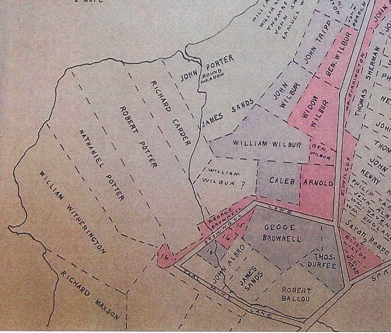
West Shore South of Bristol Ferry

Going down the highway (known as the “King’s High Road” (we know it as West Main Road), was the property of William Baulston.  This was a large tract of 240 acres and there was a small stream through it.  West thinks it might have been larger in colonial days because it was called Mill River or sometimes Two Mill River.  George Lawton had a mill on this property in 1648.  Also on this river, located nearly down to Freeborn’s Creek, was the mill of James Sands and Samuel Wilbur.  They received a grant for this mill in 1642.  William Freeborn bought the mill in 1655 and the land remained in his family until 1800.  John Tyler also had a mill on this same river.

West Shore to Cory Lane

What we know as Cory’s Lane was laid out in 1683 as “highway 2 rods wide beginning at the sea side on the west side of the Island at the head of William Freeborn’s lot and so to run that breadth to the Common at the head of the land laid out to Ralph Earl, dec.”  In 1717 it was declared a “driftway” down to the water “for the benefit of His Majesties subjects to Pass and repass through, both for cattle, horses, carts, wagons or any carriage or creature whatsoe’er.”

Touring Early Portsmouth: Bristol Ferry area

3 Comments

West Land Grant Map of Bristol Ferry Area

In the 1930s, Portsmouth historian Edward West did some remarkable work with land evidence that benefits us all. Among his works are the Land Grant Maps that tell us where the early settlers were given land. How he worked through all the locations with rods as measurements, I will never know. West tells us that upon founding the town “they immediately made laws governing the size and location of the house lots.” They began recording property in a book. There were times when land transferred without records, so the accuracy of the land evidence may be questionable in some cases. West found some of these properties as he worked with other deeds.  He also wrote an article that appeared in the Rhode Island Historical Society Journal in July of 1932 (The Lands of Portsmouth, R. I., and
a Glimpse of Its People) that gives us a commentary to go with the maps. This series of blogs will be a tour of early Portsmouth using his article and his maps.

The Bristol Ferry Area: Some of the first grants given were in the Bristol Ferry area.  As the town was laid out, Sprague Street was the southernmost border.  West tells us an interesting story.  Just above the Bristol Ferry is the 3 acre lot that Richard Searl sold to Mary Paine.  Mary was a bar-maid at Baulston’s public house.  Searl exchanged his lot for a pint of wine.  He didn’t give Mary a deed, but the town council ratified the sale on the testimony of a witness in 1666.  Mary later married John Tripp and that piece of land became the site of his ferry house.

In 1719 the land to the south of the ferry was ordered to be kept open “for the convenience of the public in importing and transporting horses, cattle, sheep, wood etc.”

The first street to the right was “Stoney Lane.”  It was a short “driftway” (a path used to drive cattle or sheep) between Richard Borden’s property and that of Mistress Harts.  South of that was a lane that led to a “watering place.”  On the map it is called Hawkins Lane for Richard Hawkins and his wife Jane who was a friend of Anne Hutchinson. (Check the reference below to learn more about Jane.) This “watering place” was laid out in 1713 as a public place for the washing of sheep and general water uses.  Also in 1713 Thomas Burton received a piece of land that was known as the “Training Place” before that.  That ground may be where the militia had trained.

Land grants were given out in 1657, 1693 and the last lands were given out in 1713.  By 1713 the commons were laid out, highways were straightened and the town was considered finished as laid out from Sprague Street northward.

Jane Hawkins:  https://portsmouthhistorynotes.com/2017/07/18/founding-mothers-jane-hawkins-accused-of-witchcraft/

West map on Portsmouth Digital Archives:  http://www.portsmouthhistorycenterarchive.org/items/show/144

Preserving Our Walls

Leave a comment

“Why should we care about stone walls?” This question was asked by a Portsmouth elementary student after I had given a presentation on stone walls to a class.  I answered that stone walls are part of our heritage as a farming community and that they are history we can touch.  I am haunted by the question because I hope Portsmouth children and other residents will appreciate the walls and work to preserve or protect our walls.  It may just be that we have so many beautiful walls that our families just don’t appreciate how special our walls are.  Sadly stone walls at Glen Park were among town property vandalized recently.  Thieves have stolen some of the critical capstones on the walls leading to Glen Manor House.  Everyday wear from people sitting or walking on the walls can dislodge stones as well.

There are efforts to preserve our walls.

Our town has an ordinance that seeks to protect the walls that border the town roads.  The Stone Wall Preservation Ordinance of the Town of Portsmouth aims “to protect one of the Town’s important cultural resources, historic stone walls, saving one of the beautiful features of the Town for the people of tomorrow and preserving the rural character of the Town.”

The Aquidneck Island Stone Wall Initiative is a joint project of the Newport County Preservation Society and Preserve Rhode Island. Their vision statement states: ” It is intended to protect and improve Aquidneck Island’s scenic quality by preserving its historic stone walls. Stone walls are visible reminders of the Island’s rural agricultural history and contribute to its sense of place and scenic character.”  With funding from the vanBuren Charitable Trust, the Initiative has restored a wall by the Simmons Farm and it is now working on a wall by the Norman Bird Sanctuary.  It is an effort to call attention to the need to preserve and protect the walls as part of our cultural heritage.

I’m not sure posting “Do not walk on the walls” signs around the athletic fields would work.  Years ago my students were researching the Leonard Brown House and the Camara Sisters (Mary Lou and Gerry) told us a story about the walls.  Mr. Nicholson, the husband of the owner of Glen Farm (Edith Taylor Nicholson) appreciated the walls and wanted the Glen Farm children to stay off of them.  He would pay them a quarter to get down off the wall.  Well, whenever the children saw Mr. Nicholson’s Cadillac coming they would get on the walls just to get their quarters!

Illustration of Children on Glen Walls

All I can do is call attention to the walls with blogs, books and talks.  Perhaps a child (or adult) might appreciate the work involved in building the walls, the beauty of the walls themselves and the farming history the walls represent.

David Shearman Builds a Wall

2 Comments

David Durfee Sherman in Civil War Uniform

One of the special treasures of the Portsmouth Historical Society is the Diary of David Durfee Shearman. Shearman was a “jack of all trades” and one trade he had was building with stone. In September of 1858 he briefly describes how he built a wall in the Bristol Ferry area.

Monday 13 – Went down and built wall for Robert Hicks. I laid the rock as fast as he dragged them, making it hard for me.

Tuesday 14: I built wall- laying out bottom; about 10 rods laid out. Robert had Christopher Dyre to help him had the rocks onto the drag and I placed them as fast as they got them along.

Rock drag

Wed 15: Built wall all day along. I build about three rods a day incline the laying of the bottom.

Saturday 18: I worked for Burrington Hicks, digging out and laying some stones for a foundation to a building banked up around the cellar.

Monday 20th : Buiilt wall for Robert Hicks, fine weather to work.

Tuesday 21: I helped Robert get some rocks for bottom part of the wall. Built wall remainder of the day.

Thursday 23: Went down and helped Robert Hicks dig rocks all day. Had two pairs of oxen-drawing some large ones. They help build the wall up first rate.

Friday 24: Rode father’s mare down and built wall till noon.

Saturday 25: Done a hard days work – finished building the piece of wall building 20 rods in less than six and a half days. I get five shillings a rod for building it. ..Going down to ferry to look at a piece of wall and set a price that I would rebuilt it for. I was pretty tired when I got home – walked nearly 8 miles.

Robert Hicks property

Note: 20 rods is 330 feet!

One estimation is that a shilling at that time was worth 40 cents.  If that is true, Shearman would have made $40 for his almost 7 days work.

Stone Walls for Many Purposes

Leave a comment

How are stone walls used around Portsmouth?

Cows at Glen Farm circa 1970

1. We are most familiar with the freestanding stone wall used for boundary marking and protecting crops or animals. They can be simple placed rocks (like a farmer’s wall) or more carefully constructed double sided walls.

2. Retaining walls hold back earth.  These have to be carefully constructed and need to have consideration for drainage of water.

Stone Bridges in the Glen

3. Bridging walls can be found down in the Glen.  They are built over small streams.

4.  Impoundment walls can be also found in the Glen.  They are designed to hold back water.  There were water powered mills at the Glen and there is a stonewall mill run area to direct the stream to the Sakonnet River.  The remains of a mill dam and the stone foundations of a mill are there as well and these are all “impoundment” type stone walls.

Remains of Dam in the Glen

5.  Foundation walls.  Most wooden buildings had stone foundations.

Every Wall is a Collection of Rocks

Leave a comment

The rocks in any stone wall are unique. They vary in size, shape, color, texture, weathering, minerals and type. They even differ in the geology of how they were formed.  

What are some types of rocks we find in Portsmouth walls?  Robert Thorson

Puddingstone at Second Beach

in Exploring Stone Walls tells us that the geology of Portsmouth is classified as  “Narragansett Basin.”  Our rocks are younger and softer than the stones in the West Bay or over on the Tiverton side of the Sakonnet.  Puddingstone, Slate, Coal and Quartzite are common.  The majority are sedimentary rocks are rocks formed from sediment. They are deposited over time, and often show layers. Conglomerate sedimentary rocks form when rounded rock pieces are cemented together.  Puddingstone is a perfect example of a conglomerate and there is more puddingstone on Aquidneck Island than other places.  The best example I can give is the rock outcropping at Surfer’s End of Second Beach. Granite is in our walls as well.  It is an igneous rock.   It forms from the slow crystallization of magma below Earth’s surface. It has grains large enough to be visible with the unaided eye.  It is one of the most common rocks and is used for countertops in our kitchens.  

Our walls look different from the walls in the communities off the island.  The fieldstone that make up our walls are flatter than those in the communities off the island.  That makes them easier to work with when a wall is put together.  Our slate, for example, is layered and can be split into slabs.  Slab type stones make the best walls.  


Good Fences Make Good Neighbors

1 Comment

Do you know exactly where your property lines are?  Do you have your garden fenced high enough to keep the rabbits out?  From the beginning, Portsmouth settlers were concerned about property boundaries and managing crops and livestock. Good fencing was called for and the town council mandated it. The book Early Records of the Town of Portsmouth is filled with concerns about fences.   References to requiring a hedge or fence begin in 1640 with all in town obligated to help create a hedge and gate with “Mr. Samford overseer.”  As land grants were given out there was a 1643 mandate that the responsibility “equally be born half by one party and half the other party – fenced in with a general fence and fences to be maintained by the proportion agreed.”  People were appointed by the town to “view the fence run,” and others were appointed as judges to determine property line disputes.

Virginia type fence

What type of fences did they have? It took a long while to clear enough stones to build a wall.  Hedges and wooden railed “Viriginia Fences” were put up before the stone walls were erected.   At first hedges are mentioned.  The first mention of stones for a stone wall comes in 1651 when Mr. Earl gives Mr. Tripp “leave to take the loose stone on the said Earl’s land of the nearest to Tripps house to make about eight rod of such wall…”

The most comprehensive rules on fences come in 1671.  Because there was damage done to cattle which caused arguments between neighbors, ” It is ordered for the time to come that he or they within the bounds of this town of Portsmouth that will make sufficient fences shall recover satisfaction of the owners …of the cattle that doth him damage.”  There was an order to have:

“…a fence called a virginia fence. It is ordered that it shall be four foot and a  half – staked with stakes half a foot above the fence plumb up and that not any of the rails be above four inches from his fellow…… And for stone wall they shall be four foot and six inches high, .. for hedge or hedge and ditch only the sufficiency of any of them.”

Four men would be viewers  to “see and view the fences when we shall have occasion to look for satisfaction for damage.”  

Although the first fences in Portsmouth were hedges and post and rail wood, stone walls became more permanent.  In his book Stone by Stone, Robert Thorson comments that eventually Rhode Island had the highest percentage of fences (78%) being made of stone.  Boundary fences would be shorter while fences to protect crops from damage or to pen in livestock were higher.

What kind of fence do you have?

The Farmer’s Wall

1 Comment

Farmer’s Wall

Portsmouth stone walls remind us of our farm heritage. Clearing the land for crops was no easy task. It wasn’t just a one time chore.  Trees had to be cut down and stumps removed.  As the soil was plowed, rocks had to be dug out and cleared away from the planting area.  Rock removal was not just a one time process.  The winter’s freeze brought up a bumper crop of rocks every year. So what was the farmer to do with the rocks?  Removing them was heavy manual labor.  They had to find them, lift them, load them onto a cart, carrying them to the edge of the field and then off-loading them.

What did the farmer do with these discarded rocks?  They made them useful.  Instead of stacking them in mounds, they used them to form the boundary of a pasture or planting field.  This type of wall goes by several names.  “Tossed,” “thrown,” “pasture,”  “stacked” or “farmer’s” wall describe the type of wall.  Robert Thorson, in Exploring Stone Walls p.67, writes:  “In a stacked wall, the stones are placed one above the other with no concern for the fit of the stones beyond nesting them together, as if they were logs in a stack of firewood.”

The “farmer’s wall” pictured in this blog is in my backyard.  It reminds me of the farmers who cleared this land for farming.  As I look at the old maps I can name the families who farmed the land that is my yard.  I think about the Bordens, the McCorries, the Fales, and the Pierces.  As I try to preserve the wall I feel connected to them all.

Portsmouth Stone Walls: Building Stone on Stone

2 Comments

Stone walls are history we can touch. They remind us of our farming history and show us the ancient property boundaries.  We are blessed with so many stone walls in our town that we often don’t notice them.  Worse, we often don’t treat the walls with the respect they deserve as part of our heritage.  The Aquidneck Island Stone Wall Initiative, a collaboration of the Preservation Society of Newport County and Preserve Rhode Island, is attempting to raise awareness of the need to preserve and rebuild our historic walls.  They have restored a wall by Simmons Farms and are now working on a wall owned by Norman Bird Sanctuary at the corner of Paradise and Third Beach Road.  On the way to the beach today, I stopped and took some photos of the process of rebuilding a wall.

The Aquidneck Island Stone Wall Initiative has posted online a wonderful resource on island stone walls and barns.  The HISTORIC RESOURCE REPORT BY JENNIFER ROBINSON provides the text for the the steps in stone wall building below.

“First, the stone is sorted by size and type, and the largest stones are placed side-by-side in two rows (each stone positioned in an oblong direction) for the foundation.

Two sides of Wall

Strings and a frame are set in the ground to guide the slope of the wall faces and the level of the courses.

Next, the courses are laid, with each row of stone being laid simultaneously on each face; stones are positioned so that all joints, or spaces, are covered (i.e. a “one stone on two, two stones on one”).

Hearting, or small filling stones, are utilized throughout for stability, and are added in the middle of the two wall faces as each course is being built.

Adding through stones

As the wall increases in size (and above 23 inches), it becomes advisable to add regularly-placed throughstones; these long stones, which run across both wall faces, provide additional stability.

Finally, slab-like copestones are added across the top of the finished wall to provide a “binding” effect to

Capstones go on last

the structure.”

Read Ms Robinson whole resource booklet online: https://www.aquidneckstonewalls.org/resources

Portsmouth Women: Artist Sarah Eddy and her Subject Fannie Scott

1 Comment

A wonderful portrait by Sarah J. Eddy has found a home back in Portsmouth. Newporter John Peixinho won the portrait at an auction and generously donated it to the Portsmouth Historical Society. Sarah painted the portraits of famous Americans such as Susan B. Anthony and Frederick Douglass, but she also painted (or photographed) the images of local Portsmouth people.

Fannie Scott by Sarah Eddy

We had a mystery to solve. Who was this lovely lady in the portrait and what relationship did she have with Sarah Eddy? There were some clues. Carved in the frame was “Portsmouth” and “1920.” The name of the subject was hard to read. Curator’s committee member Marjorie Webster thought the first name might be “Fannie” and the last name may have included the letters “ott.” Marge was almost sure it was “Fannie Scott,” a black woman in our community that would have been about seventy at the date of the portrait. That name sounded familiar. In researching the black community in Portsmouth, I had come across a “Fannie Scott.”

Who was Fannie? Her 1926 obituary in the Newport Daily News provided a wealth of clues. Around 1870 Joseph Macomber brought a group of sixteen former slaves from Virginia to Portsmouth. Fannie Edna Brent came as a young woman. Her sister, Matilda Ayler came with her husband and children as well. They became a well known farming family in the “Cozy Corners” area of Portsmouth around Turnpike Avenue and East Main Road. Fannie lived with the Ayler household and eventually married another of Macomber’s group, Robert Scott. Robert was twenty years older than Fannie.

Newspaper accounts show Fannie as active in the Friends Church. She was part of the Women’s Foreign Missionary Society in 1913 and helped cater a special dinner for service members in 1917. When her husband died in 1914, she went to live with family members at the Ayler home. Her obituary, however, shows that she spent her last days at the Home for Aged Colored People in Providence. Portsmouth Friends minister Elizabeth Trout, conducted the funeral services there and then she was buried next to her husband at the Portsmouth Friends Cemetery.

How did Sarah Eddy come to paint a portrait of Fannie? We can only guess. Sarah had a long term relationship with the Home for Aged Colored People in Providence. Every year for almost 40 years she hosted an outing at her home on Bristol Ferry Road. The elder citizens were served chowder, doughnuts, ice cream and tea. There was a short program with some speeches and singing. There were always other guests along with the members of the Home. I imagine that as a member of Portsmouth’s black community Fannie may have been one of the guests even before she came as a resident of the Home. Fannie’s grand-niece Alice Ayler Morris often sang at events at Sarah’s home.

Sarah Eddy always gave her photographs, paintings and sculptures away as gifts. She never sold any of them. She gave them as prizes, as donations for charity auctions and as gifts to the families in our community. We will treasure the gift of the portrait of Fannie Brent Scott.

Older Entries Newer Entries