Home

Newport’s Stamp Act Riots

Leave a comment

Newport had its mob scenes, especially in response to British taxes. The Stamp Act of 1765 was a tax on printed paper. All printed material in the colonies had to be produced on paper carrying a revenue stamp. Its aim was to pay for the costs of the Seven Year’s War AND to help cover the costs of Britain’s troops in the colonies. Americans saw the tax was “taxation without representation.” Stephen Hopkins had written a pamphlet – The Right of Colonies Examined – to oppose the Stamp Tax. Martin Howard of Newport wrote a pamphlet defending Parliament’s right to tax the colonists. Along with Howard, Stamp Act defenders were Dr. Thomas Moffat and Augustus Johnson, the Stamp officer.

August 26. 1765 a gallows was erected in Queen Anne Square. Effigies of the three Stamp Act defenders had been created and hung in the gallows. The effigies were guarded by William Ellery (who would sign the Declaration of Independence), Samuel Vernon and Robert Crook. These may have been leaders in the Sons of Liberty. A mob collected and after sundown the effigies were burned.

Wanton, Lyman, Hazard House was the Howard House at the time of the Stamp Act. Now property of the Newport Historical Society.

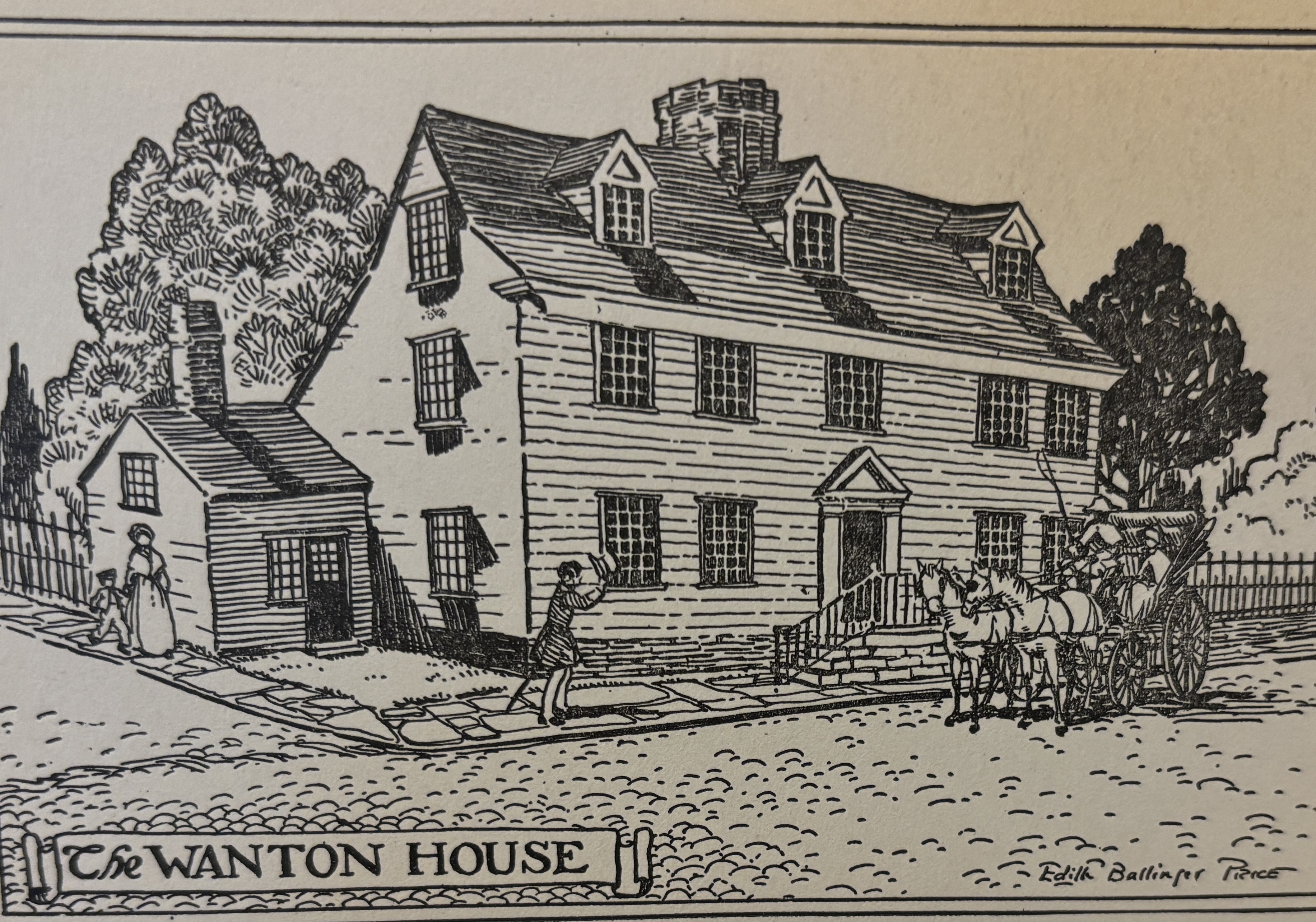
At 8 in the evening the ring leaders and a band of ruffians carrying axes and other tools, invaded Howard’s house. They demolished china, furniture, clothing and linens. They carried away his wines and liquors. They went back at 11 PM and destroyed most of the house before they headed to Dr. Moffat’s house which they also ruined. The three Stamp Act defenders had sought safety onboard the Man of War in the harbor. The crowd then surrounded the house of Stamp-Master Johnson, but since he had promised to resign his office, they didn’t carry out any destruction.

Howard and Dr. Moffat took a ship to England by the first of September.

In some circles Minister Ezra Stiles was accused of encouraging the mob. He wrote to Benjamin Frankin that while he had spoken against the Stamp Act, he always spoke against violence.

Resources:

Rhode Island Rebels: 1764 – 1769 Early Incidents – Before the Gaspee

Leave a comment

The St. John Incident: First shots

Fage map: Ft. George labeled as Battery on Goat Island.

In 1763 the British enacted a new trade policy which was aimed to clamp down on the smuggling out of Rhode Island. The British sent warships to Newport. One such warship was the custom schooner St. John. The crew of the St. John had been accused of stealing livestock and threatening to impress local seamen (forcing men to serve on British ships). On July 9, 1764 the Rhode Island Governor (Stephen Hopkins) and General Assembly ordered the gunner at Fort George on Goat Island to fire at the St. John. Accounts vary, but from eight to thirteen shots were taken. The St. John hurriedly left Newport Harbor without sustaining much damage. Some Rhode Islanders consider these the first shots fired in the Revolution.

The Maidstone Incident

June 4, 1765 the HMS Maidstone with Captain Charles Antrobus commanding, was on customs duty in Narragansett Bay.  The Maidstone’s Captain had impressed so many sailors that it effected the trade in Newport. A mob took the longboat from the ship and burned it in a town square.

The Liberty Incident

This is the account of the burning in the Boston Gazette – July 24, 1769.

“We hear from Newport, Rhode-Island, that last Monday the Sloop Liberty, Capt. Reid, said to be owned by the Commissioners, brought in there a Brig and a Sloop belong to Connecticut, that they had for some pretext seized in the Sound, which, together with the impudent behavior of the Captain and some of his People, so exasperated a number of persons there, that on Wednesday afternoon they went on board the Liberty as she lay at Anchor in the Harbour, and cut her cables, and let her drift ashore, they then set her on fire but being informed a considerable Quantity of Powder was on board, for fear of endangering the Town, they extinguished it again; they then cut away her mast, threw her guns and stores overboard, entered the Cabin and destroyed the Captains and his wife’s cloaths, bedding, broke the tables, chairs, china and other things therein, and did not quit her til 3 oclock the next morning, when after scuttling the vessel, they left her a meer Wreck, and now remains sunk near one of the wharfs there. They also seized her barge and boat and burnt them – The Brig that was seized we hear was legally discharged on Thursday, but that the Sloop made her escape in the confusion the evening before.”On the 19th of July in 1769 a Newport mob was so exasperated with the captain of a sloop owned by Royal Commissioners that they “went on board the Liberty as she lay at Anchor in the Harbour, and cut her cables, and let her drift ashore, they then set her on fire…” (Boston Chronicles, 24, July 1769).

This incident was almost three years before the burning of the Gaspee.

Resources:

Revolutionary Rhode Island Women: Christian Stelle Banister in Occupied Newport

Leave a comment

The name Banister (Bannister) still exists on a popular wharf in Newport. John and his wife Christian were wealthy landowners in Newport before the coming of the Revolutionary War. Many of the land rich class in Newport became Loyalists. John’s brother Thomas even joined a Loyalist militia. John is not included on lists of Loyalists, but he and his wife were in a peculiar position once the British occupied Newport in 1776. John would ultimately sail for England to ask for reparations from the British for the damage done to his properties, but that left Christian and her young son to face life in Occupied Newport on their own. Marian Mathison Desrosiers book, The Banisters of Rhode Island During the American Revolution, provides details of Occupation life for Christian and others in Newport.

Newport was a Loyalist leaning town, so at first British occupation was not severe. Christian would have been able to go through her normal routines of shopping and visiting. Many of the merchants and tradespeople were able to continue their work. But there were hardships. Even during the first week of occupation Aquidneck Island families found their livestock confiscated to feed British troops. Island families could catch fish and hunt birds. Normal colonial trade was cut off, so Newport residents found themselves without items like wine and liquors.

As time went by there were further restrictions. Christian was distressed that she could not make some of her normal visits to family. By June of 1777 the British enclosed the Newport area with gates and citizens were required to get passes to even visit friends in Middletown or Portsmouth. The citizens lost their freedoms and their elected government. The British military was the law.

Occupation became progressively difficult and Christian and other women left alone had to deal with property loss, destruction of their orchards and trees, loss of personal freedom and lack of food and fuel. In December of 1778 British General Prescott ordered the army to cut up wood fences, old docks and boats, and even church pews to keep his soldiers warm and cook their food.

Christian’s husband remained in London for years trying to get repayment for his losses. Meanwhile, Christian hung on in Newport. In July of 1780 the French arrived. Unlike the British, the French paid for items, restored damaged homes and brought a sense of civility to Newport.

Christian’s husband returned after four years in England. She had managed to keep things going during his absence and the family benefited from her struggles. Her Loyalist brother in law Thomas lost all his property, but John and Christian did not. Eventually the Banister’s would make South Kingston their home.

Gilbert Stuart Portrait of Christian and her son John. Original at Redwood Library

In Their Own Words: Marking the Border

Leave a comment

Do you know where the boundary between Portsmouth and Newport is today? Trick question. There hasn’t been a Newport/Portsmouth boundary since 1743. Aquidneck Island was divided about in half between Newport and Portsmouth after Newport’s founding in 1639. Middletown was carved out of Newport’s half of the island and became a town on its own in 1743.

One of the documents in the collection of the Portsmouth Historical Society is an account of how the boundary between Portsmouth and Newport was marked again in 1666. Like a number of our documents, it is a “true copy” of an earlier recorded document. The document includes a note saying that it is a “true copy extracted out of these records belonging to the Town of Portsmouth and compared. Mr. John Anthony signed the document and he was Clerk in the 1680s so this particular copy dates from that time.

According to the document, John Albro (for Portsmouth) and William Dyer (for Newport) were appointed to lay a line of division between the towns. They started in the northeastern corner and marked the boundaries by labeling trees with N on the Newport side and P for the Portsmouth side.

I believe that the 1666 boundary marking is a remarking of the border. Digging into old Aquidneck Island histories *, it is clear that there was a delegation from each of the two towns (Easton and Porter from Newport and Jeffreys and Sanford for Portsmouth) to mark the official boundaries by November of 1640. They started at the Sakonnet River south of William Brenton’s land (which was around the Glen area) and marked trees in a straight line toward the “sea” using a brook and a “hunting wigwam” as part of the landmarks.

What can we learn about life for early residents of Portsmouth from this document. Borders, boundaries and property lines were very important to them. Logically the borders needed to be remarked as trees fall and local landmarks change. There may have been many more such boundary markings. Today we may mark town borders at East and West Main Road, but we don’t seem as interested in marking the boundaries across the island.

Interested in reading the full transcription? The transcriptions will be available on the Portsmouth Historical Society website: http://www.portsmouthhistorical.com Click on the “transcriptions” heading.

*Bayles History of Newport County,1888.

Newport Portsmouth Border

Newport Portsmouth Border