I have come across an excellent source that gives us easy access to many of the maps of the Revolutionary Rhode Island era. https://www.argomaps.org/about/ is the link to this great source.
From their website:
“ARGO: American Revolutionary Geographies Online is a new project led by the Leventhal Map and Education Center at the Boston Public Library and the George Washington Presidential Library at Mount Vernon. Leveraging new technology and the recent drive by many museums, libraries, and archives to digitize their collections, the portal collates digitized maps of North America made between 1750 and 1800 into a single user-friendly portal. In addition to providing users from many backgrounds with easy, intuitive access to beautiful high-resolution images, ARGO seeks to give users of all kinds the tools they need to learn and understand through interpretive essays, curated collections, classroom materials, and more. As a platform for scholarship, education, and exploration, the goal of ARGO is to make the rich visual legacy of our Revolutionary past accessible to the public as never before.”
ARGO’s Advice on using maps as a primary source.
Our number one piece of advice? Take time to look. Just as you would read and reread any other primary source document, be sure to examine your selected map. You can look over the map with the following questions in mind:
What does the map focus on?
How did the maker get you to focus? Did they use color? Are some things larger than others (scale)? What is at the center of the map? What features are accompanied by text?
What is overlooked? What is unlabeled, at the edges, or missing altogether?
How is the map intended to be used? To show political boundaries? Navigation? Sharing data? Depicting a particular place for promotion or propaganda?
What i do:
- I always look at the cataloguing information. It usually gives me such information as who the mapmaker was, when was it made, size, etc. Who the mapmaker was can tell us something about the intention of the map.
- I do look at the whole map, but I also break it down and specifically take note of what is in sections. Usually I look at the map in four sections. That helps me to notice minor details that may be important.
- I try to find a map of the same location today. Names change. McCorrie Point is frequently referred to as “Sandy Point” at the time.
- I always look for detail like the compass for orientation, scale, and legend. If this map is a rough sketch, these items might not be present.
Here is an example of how I work with a map that is new to me.
Checking out the bibliographic information.
What information can I cull?
Author: signed H.C. – this is in the Henry Clinton collection
Title: Taken from the back of the map.
Size: about 16 by 13 inches.
Materials: Pen and ink
Notes: Depth soundings are listed. Are they in fathoms? At one location the “Feet” is listed. American and British redoubts are included.
Now I have some information to bring to viewing the actual map. https://www.argomaps.org/maps/commonwealth-oai:hd76wz10d/
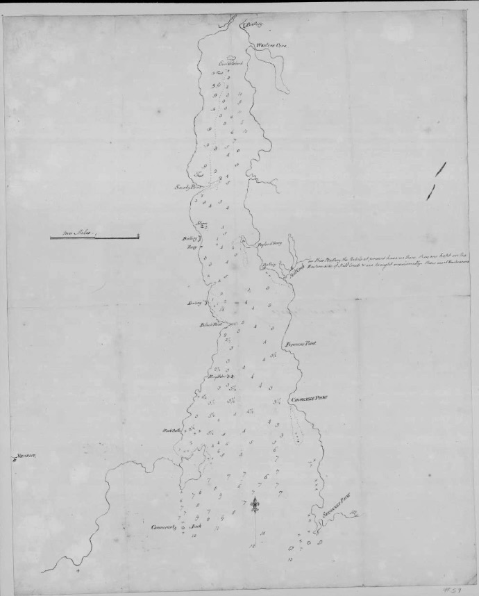
My observations: Although this map has a scale and a compass, it doesn’t have a legend, maker’s name or date. It seems to be a utilitarian map prepared for those defending the East coast of the Sakonnet. The passage depths listed and the scale helps defenders pinpoint locations where the Americans are most likely to cross. There is a special note about the redoubt at the Mill Pond – how it is armed and what weapons they have. As I expected, “Sandy Point” on the map is what we call McCorrie Point. There is even a tracing of what the point is like at low tide. American and British redoubts are listed. It would be good to compare them to other maps to get a sense of the dating of this map. The ferry locations are also listed.

Leave a comment