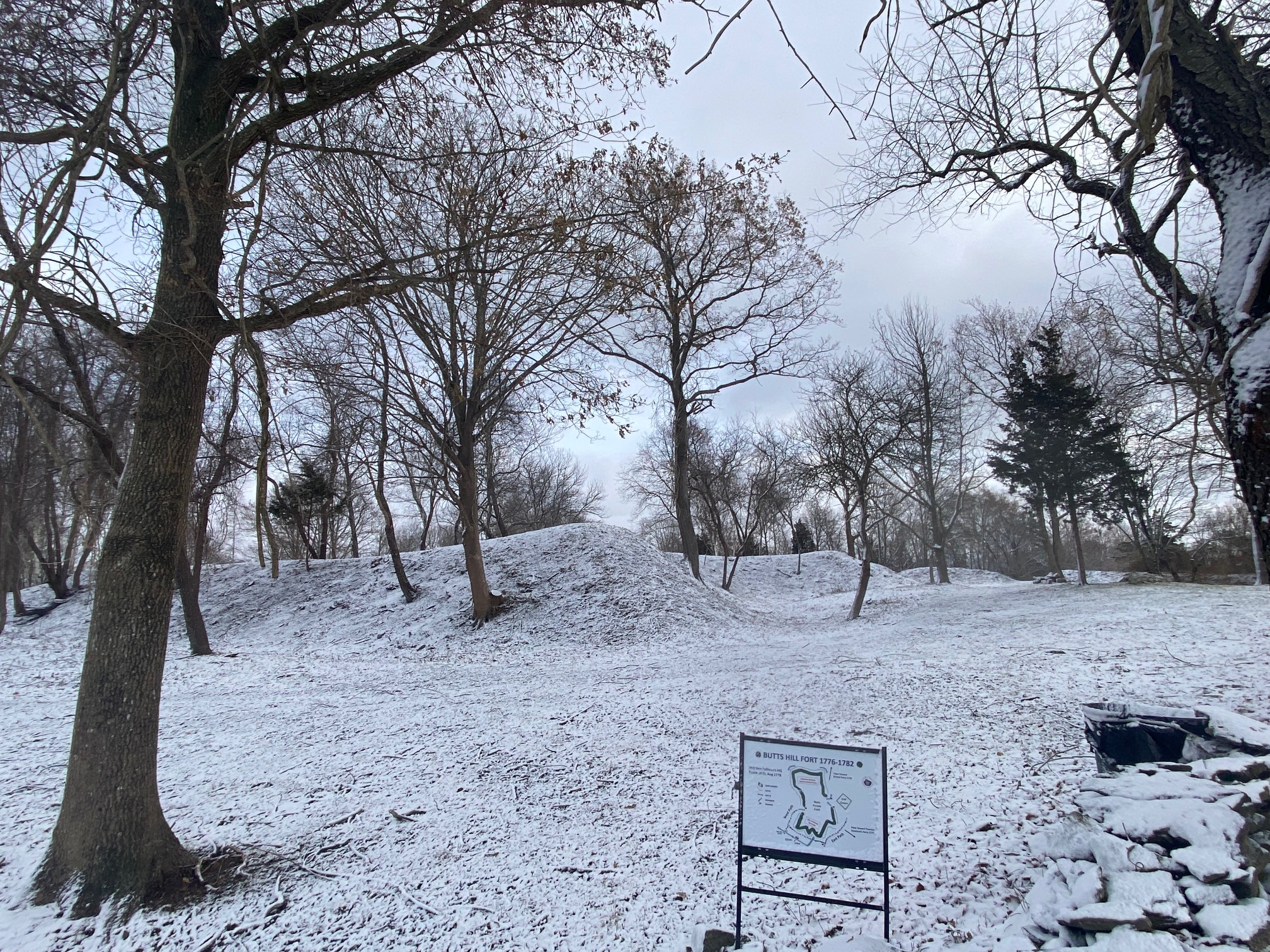
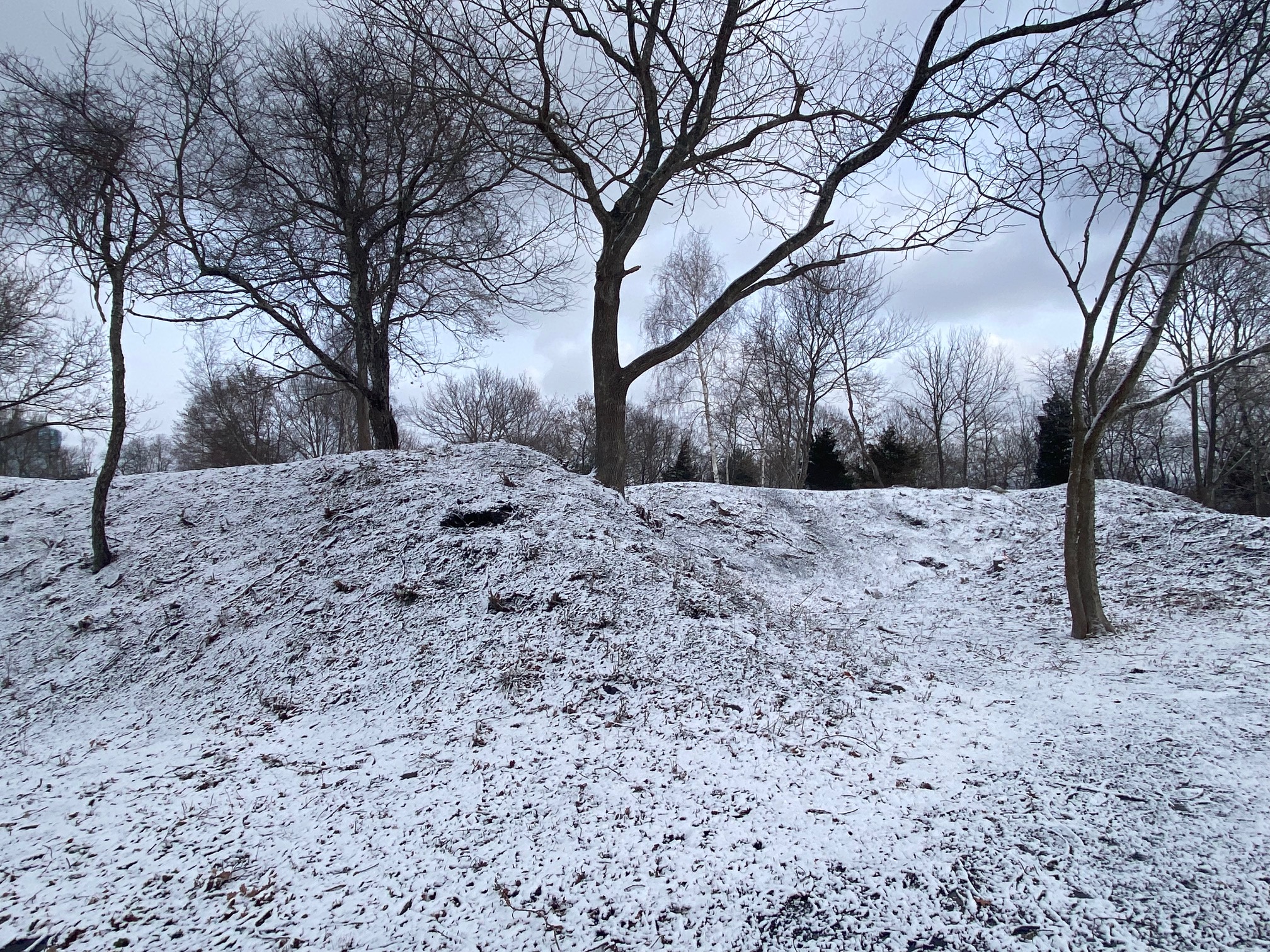
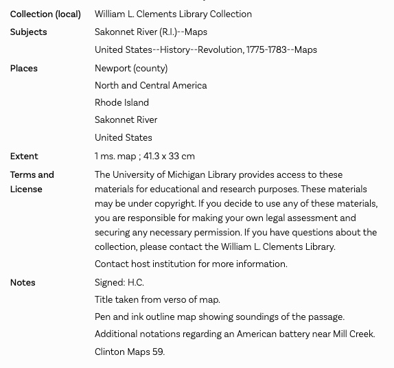
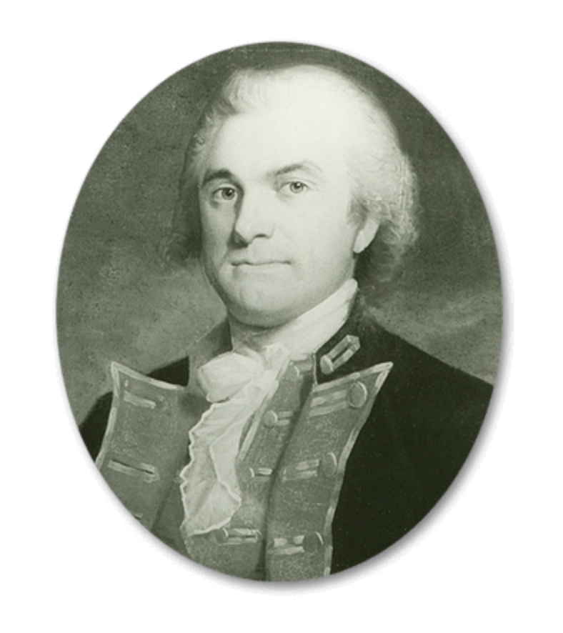
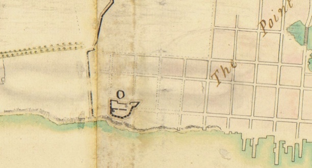
Home

When Did Butts Hill Fort Begin?

Comments Off on When Did Butts Hill Fort Begin?

This post is for subscribers

Occupied Portsmouth: Fogland Ferry Fortifications

1 Comment

Erich A. O’D. Taylor’s pamphlet “Campaign on Rhode Island 1778” is among the resources in Jim Garman’s collection. It is richly illustrated with woodcuts by noted artist John Norman Benson. We always have to doublecheck the information in older histories, but I found some interesting information in this source that I believe is worth sharing. Some of the information is based on the diary of a Hessian soldier (Johann Conrad Döhla).

On October 22, 1777 there were rumors of a landing on Fogland. American General Spencer did not try that, but British General Pigott strengthened the works at Butts Hill, Fogland Ferry and Lawton’s Valley in Portsmouth. He enclosed Newport with enceinte (encircling walls), cutting off even the main roads with gates that were locked at night. This line was first manned December 17, 1777. NOTE: This confirms what I read in a letter by Mrs. Bannister in Desrosiers, The Banisters of Rhode Island in the American Revolution: Liberty and the Costs of Loyalties.

Turning to the Fogland Ferry area off Glen Road:

Ferries had crossed between the Glen area and Fogland in Tiverton since the 1640s. This was another narrow spot on the Sakonnet shore and the British considered this a very vulnerable spot. Barracks and defensive fortifications were constructed there.

Taylor wrote:
“The commander at Fogland Ferry had no small task before him to safeguard the nearby farms. It is interesting to learn therefore that this important position was usually assigned to Hessian regiments and was so well defended and its duties so well executed that the inhabitants complimented the commanders when they were relieved and returned to town. Among those who returned thanks to Captain Baron de Malsburg of the regiment Ansbach-Bayreuth on his leaving this post are to be found – Mr. Bowler, Restcome Sanford, Elisha Coggeshall, George Martin, Jonathan Davenport, John Lawton, Giles Slocum, George Taber, Giles Lawton and John Sanford… The farmers thoroughly understood the Hessian soldiers who came of a range of agriculturalists like themselves. During the quiet summers of 77 and 79 when no ‘assault was intended on the city,’ many of these Hessians hired themselves out to farmers, working for the small wage of (about 51 cents ) a day.”

Metcalf Bowler, Giles Slocum, John Sanford and others did indeed have farms in that area. The idea that the Hessians helped out on the farms is something new to me. I will be able to read Dohla’s diary and I will look for sources to confirm this. Metcalf Bowler, we discovered later, was acting as a British spy. Taylor hints that there were Loyalists among the Portsmouth farmers, but with the severe damage done to the farms during the Occupation I doubt many Portsmouth farmers appreciated the British Occupation.

An Occupied Island

Leave a comment

A general Introduction:

The British had ample reason to invade and occupy Aquidneck Island (called Rhode Island at that time). Newport had a fine harbor from which the British fleet could raid up and down the coast. It would enable them to blockade ships carrying supplies from abroad that were needed by the Americans. On December 8, 1776, British General Prescott landed at Weaver’s Cove. The American militiamen were unable to mount a defense and they escaped by using the ferries to Bristol and Tiverton.

Des Barres Map 1776. Note Weaver’s Cove landing site top left.

The British Occupation of Rhode Island would last until October of 1779. Life for the residents deteriorated throughout that time. There were different experiences for those who lived in Newport and those who lived in the farmlands of Middletown and Portsmouth. Newport had more British sympathizers and life for them was good at first. The well to do and British enjoyed concerts, dances, card parties, and Christmas concerts after the British first arrived in 1776. In 1777 daily routines continued. The occupiers took over houses, shops, wharves, and farms. The British and Hessians came with wives and children and all needed food, supplies, housing and heat. The residents competed with the British for scare items. The British took hay and confiscated cattle and livestock. Residents could hunt birds, catch fish and collect shellfish. The British collected boats and guns. The longer the Occupation lasted, the harder it was on those in the maritime trades such as coopers, sailors, rope makers, etc. Wharves were pulled up for fire wood. Merchants had no supplies coming in so they had little to sell.

Local citizens couldn’t count on growing food for their families. Gardens were raided, fruit was plucked from trees and potatoes were dug up by British soldiers. There was no freedom of movement. Women could travel a little more freely at first, but later they needed passes to leave town. The border of Newport and the rest of the island was gated and locked There was no free press or local government. Births, deaths, marriages were not recorded and Newport lost its property records when the British shipped them to New York and they were ruined by water.

Destruction was even more disastrous when the French fleet was arriving in August of 1778. In creating defensive works. the British demolished homes, chopped down orchards and trees for abatis (a defensive obstacle formed by felled trees with sharpened branches facing the enemy.). Conditions worsened after the Battle of Rhode Island and through to October of 1779 when the British left the island.

Resources:

A chart of the harbour of Rhode Island and Narraganset Bay surveyed in pursuance of directions from the Lords of Trade to His Majesty’s surveyor general for the northern district of North America : published at the request of the Right Honourable Lord Viscount Howe / by J.F.W. Des Barres, Esqr., 20th July 1776.

The Banisters of Rhode Island in the American Revolution: Liberty and the Costs of Loyalties
by Marian Mathison Desrosiers, Dec 14, 2020. The Bannisters lived through Occupation in Newport and this book provides insights.

Portsmouth Women: Enduring a “Distressed Situation”

Leave a comment

As the memorial stone at Butts Hill Fort reads, it is important for us to honor the “memory of those brave men who” fought in the Battle of Rhode Island”. It is also important for us to remember the Portsmouth women and their families who endured almost three years of British Occupation from December of 1776 to October of 1779. When the Portsmouth Town Council was able to meet again in 1779, the members pleaded with the state to have pity on us because the town was in a “Distressed Situation.” As I research this Revolutionary Era in Portsmouth history, the plight of Portsmouth women and their families was indeed disstressed.

What was Portsmouth like when the British came? The diary of British soldier Frederick Mackenzie provides a rosy picture. “There is a hill about 7 miles from Newport, and on the Eastern side of this Island called Quaker Hill, from there being a Quaker meeting-house on it, from whence there is a very fine view of all the N. part of the Island, and the beautiful bays and inlets, with the distant view of towns, farms, and cultivated lands intermixed with woods, together with the many views of the adjacent waters, contribute to make this, even at this bleak season of the year, the finest, most diversified, and extensive prospect I have seen in America.” This fine prospect did not last long under British military control. Much has been written about Occupied Newport, but the situation in Portsmouth had its own set of troubles. At times citizens were allowed to leave the island, but if you were a Portsmouth farm family you stayed to work and protect your farm. There were many Loyalists in the commercial port of Newport, but the majority of families in Portsmouth leaned towards the Rebel side. Only about ten percent of Portsmouth citizens left the island.

What happened to Portsmouth women and their families when the British arrived? British maps from the Revolutionary Era give us some idea.

  1. Some families lost their homes. For example, the British fortified Bristol Ferry and they tore down homes that blocked their vision of the ferry landing. Some houses were taken over as barracks for troops or as housing for officers and generals.
  2. Almost all families lost their trees and orchards. As time went by just about every tree on the island was cut down for firewood. The families were left in the cold while the British warmed their troops.
  3. Farm families lost their livestock. There were many soldiers to be fed. Mackenzie’s diary says the British left families with a means of feeding themselves. They could keep one gun to hunt birds and they could keep a boat for fishing.
  4. The British took just about every wagon and wooden farm tool. Wooden vehicles were used by the British for carrying loads, and almost anything wooden was burned for fuel.
  5. Women assumed greater responsibility to care for their families. With the exception of Quaker families, almost all Portsmouth men served some time in the American cause. Even those who were on the island during the Occupation were impressed into service by the British to work on fortifications on Butts Hill and elsewhere.
  6. When the British left the island they filled in just about every well – the source of water for families.

At the withdrawal of British troops in 1779, Portsmouth farm families had a difficult time getting their farms back into operation. Families listed their losses in hopes of getting some reparations. One of these lists is in the collection of the Portsmouth Historical Society. It gives us an idea of how devastating the household losses were. This list shows the losses of Edward Binney and Elizabeth Heffernan – in-laws who lived in a joint household just north of the Friends Meeting House on Quaker Hill.

Among the losses:

Livestock: 2 cows, one calf, 5 hogs, 12 goats, 1 jackass

5 acres of orchards, a cider press and mill, 4 acres of corn, 12 loads of hay,

Farm tools: An ox-cart, 3 hoes, forks, 2 spades

Household goods: desks, beds, drawers, wood cards, kettles, pots, gowns, tablecloths, etc.

It is clear that we should honor the brave Portsmouth women who cared for their families under such difficult circumstances.

North Battery, Newport – aka Fort Greene and Battery Park

Leave a comment

Battery Park in Newport is a lovely place to sit and view the harbor. From its name you can imagine that it was the site of a battery (a cluster of cannons) during the American War for Independence). The British called it North Battery and it was an important element in the defenses of Newport. British soldier Frederick Mackenzie writes in his diary in September of 1777 that they were doing the principal work “enclosing the town of Newport from Easton’s beach, round the three windmills, to the North Battery and extent of 3000 yards.”

The Battery began as an earthen work begun by American forces. The British re-enforced this so it could be manned by seven soldiers. In preparation for the arrival of the French fleet in 1778, the British thickened the walls and installed guns. The battery was part of the defenses to protect Newport from a sea attack and was armed with two 24-pound and three 12-pound cannons.

When the British abandoned Aquidneck Island in December of 1779, they leveled the fortifications at North Battery. The Americans tried to reconstruct the battery when they returned to the Aquidneck Island. The North Battery was re-named Fort Greene in 1798 in honor of Rhode Island’s General Nathanael Greene.

Resources: Kathy Abbass’ Rhode Tour:

https://rhodetour.org/items/show/54

“Plan of the town and environs of Newport, Rhode Island / Exhibiting its defenses formed before the 8th of August 1778 when the French fleet engaged and passed the batteries, the course of the French fleet up the harbor, the rebel attack and such defensive works as were erected since that day untill the 29th of August when the siege was raised; also the works proposed to be erected in the present year 1779..” https://quod.lib.umich.edu/w/wcl1ic/x-6052/wcl006125. University of Michigan Library Digital Collections.

“The Works” : Green-end, Dudley, Bannister’s Irishes, and Tomini

1 Comment

Frederick Mackenzie’s Diary and Edward Fage Maps give us an idea of the preparations the British made for an American attack in June of 1778.

Mackenzie diary, June 6, 1778: “A new Chain of Redoubts lately constructed for the defense of Newport, are now complete. The ground in all parts extremely advantageous; but I think some of the Redoubts are not well placed and that in general they are too confined. They are called, Green-end, Dudley’s, Bannister’s, Irishes, and Tomini….”

Mackenzie expresses concerns about the Green End Redoubt. It is “very small” and intended for 3 guns. He laments that a soldier in one of these redoubts could only “fire directly forward…” He muses that the engineer designed it to “show his fancy.” The Green End Redoubt was on the high ground above Green End Pond to complete the outer walls of defense. Two thousand British and Hessian soldiers as well as Loyalist volunteers would be stationed along the redoubt lines. While construction was going on General Pigot ordered all trees to be chopped down and all houses burned down so that the enemy could be detected.* Later in the diary entry Mackenzie suggests that another redoubt should be built to the right of this redoubt to have better control over Easton’s Pond.

Mackenzie states “Dudley’s Redoubt is certainly placed too far back. If it had been about 60 yards forward it would have answered every purpose much better.” Charles Dudley, the owner of the land on which the redoubt was built, had left in 1775. His home had become a hospital before the redoubt was built.

Mackenzie goes on to write: “Bannister’s and Irishes have a very good command of the adjacent ground.” He would have changed the position of Irishes Redoubt. The John Bannister family (Loyalists) had been at their Middletown country home. The British tore down the home next door that had belonged to George Irish who had left to join the Rebels. Marian Desrosiers in her book about the Banister family wrote:

“The redoubts the British built on both the Irish and Banister properties were about thirty to fifty yards on two sides and twenty yards in front of each redoubt to prevent American solders from storming the area.” (1).

Fage’s map of the Works

Thomas Banister had left Rhode Island to fight with loyalists and the British took over his estate, “West Farm”, that included the high ground at Miantonomi Hill. Mackenzie wrote: “Little Tomini should certainly have been formed as an outwork to the great hill. A single gun, en barrette, in a small work, open behind, would have been of service, as it would command a good deal of ground unseen from Great Tomini.” He saw Little Tomini as a liability.

References:

(1) Desrosiers, Marian Mathison. The Banisters of Rhode Island in the American Revolution. MacFarland, 2020.

Fage, Edward. Plan of the works which form the exterior line of defense for the Town of Newport. 1778. Clinton Collection, Clement Library.

Mackenzie, Frederick. Diary of Frederick Mackenzie, Vol. 1. Harvard Press,

Fortified Portsmouth – Continued

Leave a comment

Maps by Edward Fage of the Royal Artillery provide us with a visual record of the British fortifications on occupied Aquidneck Island. There are many maps made by Fage and they each have different details that add to the story. Many of them are in the Clinton collection of maps at the Clement Library and are available online.

The Huntington Library map illustrated the fortification in North Portsmouth, so I will focus this blog on the fortifications on the rest of Portsmouth. I will try to match some of Frederick Mackenzie’s diary with the images from the Fage maps.

Mackenzie’s Diary: June 13, 1778
“The following are the present stations of the troops on this Island. –

Bunau’s Regt – At Windmill hill: This Regt furnishes all the posts at the North End, in front of a line drawn from their right & left to the Shore.
22d Regt At Quaker hill on the East road, their right to the Seconnet. They furnish the posts on the East shore, from Ewing’s, as far as McCurrie’s.
43rd Regt On the left of the West road, near Turkey hill: four Companies with their right to the W. Road; and four Companies, 200 yards to their left. They furnish the posts on the West shore, from the left of Bunau’s Regt as far as the Creek of Layton’s Mills.
A Detachment of 80 Hessians from the three Battalions in Newport, at Fogland Ferry. This detachment furnishes the post at Fogland, and Patroles as far as little Sandy-point, on their right.

54th Regt At the Blacksmith’s on the E. road. Their right to the road, and to that which leads up from Lopez’s house; furnishing the posts from Sandy point to Black point.
All the above mentioned Troops report to General Smith, and furnish a chain of post and patroles from Black point on the E. side, round to Layton’s Creek on the West.”

“Windmill Hill” (Butts Hill), Turkey Hill and Quaker Hill have been covered in previous blogs, but Fogland and the Lopez site have not been covered. At that time the old Fogland Ferry was approximately where the docks now are at the Glen Manor House. This was an important defensive post because this is a narrow spot from Tiverton to Portsmouth and the troops were guarding against Rebels slipping through to the island over night. When H.A.C. Taylor of Glen Farm bought this land north of Glen Road (in the late 1880s), vestiges of the Fogland fortifications could still be seen.

Diagrams in the Clinton Map collection of the Clement Library help us to visualize what some of these fortifications looked like.

Lopez’s House is mentioned and several maps show a Lopez Bay. This is property owned by Greenvale Vineyards today. There was a wide dirt road from Lopez’ home on Wapping Road to the Sakonnet River that Aaron Lopez is believed to have used for smuggling of goods. This location became part of the British defensive positions. In the Clinton Collection there is a diagram of the Lopez fortifications, but I wonder if that was a plan that didn’t become a reality, but another of Fage’s maps shows a fortification there, entrenched and as a barrack.

Elam’s House (Vaucluse) also has fortifications as an “Intrenched House as a Barrack.” There is a small redoubt below Sandy Point that is listed as made in October 1776. That would date it as started by the Americans.

More Fortifications in Portsmouth from the Huntington Map

Leave a comment

Windmill Hill (Butts Hill) from Huntington Map

Information from the Huntington Library map gives us a picture of the fortifications at Butts Hill and other locations in Portsmouth during the British Occupation. The map’s purpose to show “the British posts of defence as compleated during the possession of Rhode Island, from the 8th of Dec. 1776 to the 25th of Oct. 1778.” It covers only the Northern portion of “the Township of Portsmouth”.

The map adds to our understanding of the structure of Windmill Hill (Butts Hill) Fort at the time of the Battle of Rhode Island. On the map you can see the abatis around the Windmill Hill Barrack and the Redoubt and Battery. The fortification is dated from 1776, and that confirms that it was begun by the Americans.

The map even provides information on Rebel constructed fortifications that the British destroyed. To the left of the depiction of the Windmill Hill is a handwritten note: “All the works in colored yellow were made by the Rebels August 30, 1778 but immediately after their retreat were filled in by us.” Another part of the map shows “fleches” made by the Americans on August 30, 1778. This was a new term for me. It derives from the old French word for arrow. “An earthwork consisting of two berms forming an angle with an open gorge.”

“Fleches” made by Rebels

On West Main Road, southwest of Butts Hill Fort, there is an artillery redoubt listed as made in September of 1776. This also must have originated with the Americans. Looking at a Fage map, this redoubt might be labeled as “Burrington Hill.” Durfee’s Hill and Lehigh Hill are other names for it.

There are handwritten notes that add information like what structures in Portsmouth became barracks, whose orchards were cut down, and the location of local homes by owner’s names.

The British positions for the Battle of Rhode Island are quite prominently labeled.

The Huntington Map can be found online: https://hdl.huntington.org/digital/collection/p15150coll4/id/16295/rec/3

Fortifications (American and British) in Northern Portsmouth

Leave a comment

Maps provide a prime source of information on the British fortifications on Aquidneck Island, and the North Portsmouth map from the Huntington Digital Library provides some interesting information. From the notes we get a glimpse of what the American fortifications were before the British Occupation. In some cases the British enlarged what had already existed. In other cases they constructed fortifications to secure their own needs.

Starting at the Bristol Ferry area:

Looking at a modern map the location of this redoubt seems be where the Bristol Landing Condos are today. The note says “Left by the Rebels ___1775 nearly finished.” The diagram in the Henry Clinton Collection of the William Clements Library gives us more details.

A diary entry from a British soldier, Frederick Mackenzie, gives us an idea of the fort changing hands in the initial actions after the occupation.

“Dec 8th 1776 – The Army landed this morning at Weaver’s Cove near Mr. Stoddards House…
The first embarkation under General Prescott, marches as soon as formed to the high road from Newport to Bristol Ferry, a short distance from the landing place, and finding that the few of the Enemy who were on the Island, had retired in haste towards the N. End of it, he pursued them to the ferries, where he took a few prisoners and a 9 lb cannon; and save a great many cattle and sheep which they had not time to Carry off.

The Rebels abandoned a well situated fort at the N. End of the Island yesterday, without attempting to defend it. It in some measure commands the passage to Bristol by the ferry.”

Heading east on the map we see the fortifications heading toward Common Fence Point.

The redoubt by the Lawton house was labeled “made a Redoubt July 1776 now demolished”. That would have been an American fortification. Looking at a map today, it seems to be in the Anthony Road/Boyd’s Lane area to the south of Town Pond. In the direction of Common Fence Point there is a line of “abbatis” which is an obstacle made by cutting down trees, interlacing them and having the sharp points face the enemy. What we call Anthony Road was labeled Common Fence Road on the map.

The map labels a “Common Fence Redoubt” but the modern location is actually closer to East Main Road. There were fortifications toward Howland Ferry. We don’t think of a bridge being on Park Avenue, but early maps show a bridge there. The Bridge Redoubt is listed as September of 1776 which would have made it an American fortification originally.

A map made by Fage in 1778 that is part of the Clinton Collection at the Clements Library helps us to view the fortifications as a whole. One would think that the Common Fence Redoubt would be on Common Fence Point and the Bridge Redoubt would be close to the bridge to the Howland Ferry, but their locations on the map seem to be somewhat puzzling. Perhaps they were guarding the way from Common Fence Point and guarding the way from the bridge. The positions of the redoubts put them closer to established central roads. Howland Ferry was an important location. It is close to where the remains of Stone Bridge are today. It was a narrow spot between Aquidneck Island and the mainland at Tiverton. From Mackenzie’s Diary: Oct. 20, 1777 In order to strengthen the post at Howland’s bridge, an abbatiss of large apple trees from the neighboring Orchards was thrown across the Neck about 200 yards this side of the bridge, which will prevent the enemy from advancing in that part with Cannon or any considerable number of troops without first removing them, which will take u some time and must be done under our fire.”

Oct 21, 1777 – “We have had some convincing proofs of late of the bad construction of Howland Bridge Redoubt.  The 9 pounders place in the right embrasure could not be brought to bear on the ground from which the Rebels fired the night of the …”

Nov. 26, 1777 – “An Abbattis was made this morning from the shore at the Mouth of the town pond for 300 yards o the right along the edge of the pond, which is passable at low water.”

March 16, 1778
“The 43rd regiment having undertaken to supply themselves with the necessary quantity of wood from Commonfence Neck, during the time they continued on duty at the advanced posts,& having employed several carts yesterday in drawing away what had been cut near Hick’s orchard…”

Fage Map 1778

Occupied Portsmouth: The Redcoats Chopped all the Wood in Sight

Leave a comment

A number of years ago I was privileged to take a tour of the Glen with arborist Matt Largess. He commented that the Glen itself was one of the few areas on the island with old growth trees because the British were not able to easily cut down the trees during the occupation of the Island. That explained why in the 1850s the Glen would be an attraction because its natural beauty had been preserved.

When Maj. Frederick Mackenzie of the British forces arrived on the island in December of 1776, the winter was mild and he writes little about woodcutting in his diary. But the winter of 1778 was extremely cold. On June 15, 1778 Mackenzie wrote: “The consumption of Wood for the Garrison last winter was about 300 cords per week. It would be less expensive to send Coals from England.” A cord of wood measures 8 feet long, 4 feet high and 4 feet wide. It wasn’t only the troops that needed wood to survive a cold winter – it was also needed by those colonists who stayed on the island. Timber in Portsmouth was not always easy to cut. Mackenzie records: “Officer and 36 British went into the Country today, to be employed in cutting wood in a large Swamp on this side of Fogland Ferry, for the use of the Garrison. It is computed that there are about 400 Cords in the Swamp, but it cannot be got at but during a hard frost.” Figuring out where that swampy area was is difficult for us, but Edward West’s article “Lands of Portsmouth” notes two Swamps in the area of Mint Water Brook on either side of East Main Road.

At first the British and Hessians felled the trees closest to their camps. The Hessians had a camp above Fogland Ferry. They continued to cut further away until there were no trees to cut and burn. Mackenzie records that they then turned to cutting down orchards next on Common Fence Point and other locations. After the orchards, all other sources of wood were eyed. Vacant houses, wood carriages, and even wooden farm tools went into the wood supply. Mackenzie writes on December 6th, 1778: Every step is being taken to supply fuel: All the timber trees on the island are cutting down and the old wharves will be broken up.” Vacant houses were taken apart and the wood was used for fuel. Rail fences were taken apart and burned. On December 13th his diary entry reads: “All the carriages that can be collected on the Island are employed in bringing in the wood which is cut by the party out on the island.” “Turf” was cut on Brenton’s Neck and used for fuel. When the island was exhausted, they sent fleets out to collect wood on Conanicut, Block Island and Long Island.

When the Occupation was over, those remaining on the island had a difficult time rebuilding homes and barns. Many Portsmouth farmers turned to wood from Tiverton to begin to restore their buildings.

Sources:

Diary of Frederick Mackenzie
Giving a Daily Narrative of His Military Service as an Officer of the Regiment of Royal Welch Fusiliers during the Years 1775-1781 in Massachusetts, Rhode Island, and New York, Volume II

Edward West: ” The Lands of Portsmouth, RI” – Rhode Island Historical Society Journal, July, 1932.

Herbert E. Slayton: newspaper clipping November 12, 1937: They’d Keep Warm Enough – in collection of Portsmouth Historical Society. https://portsmouthhistorical.org/wp-content/uploads/2016/12/Scrapbook-Part-5-p41-49-p50-Blank.pdf

Fage, Edward: Plan of Rhode Island and the Harbour. 1778. Available online: https://collections.leventhalmap.org/search/commonwealth:hx11z3134

Older Entries