It is hard for us to picture what Butts Hill Fort looked like when it ceased operation in 1781 (some say 1782). The French and Americans took the British fortifications, enclosed them and really make them into a real fort. I am searching for clues among the records of that time, maps, orderly books and those like Benson Lossing who record what they saw at the fort years after the abandonment of the fortification. I am trying to do this in an orderly way, putting together the clues of the primary sources. I have needed an education in military terms, so I have tried to put a definition next to words I had to research.
Today I am working with the Pictorial Field Book of the Revolution, Vol. 1. This was published in 1850 by Benson Lossing.
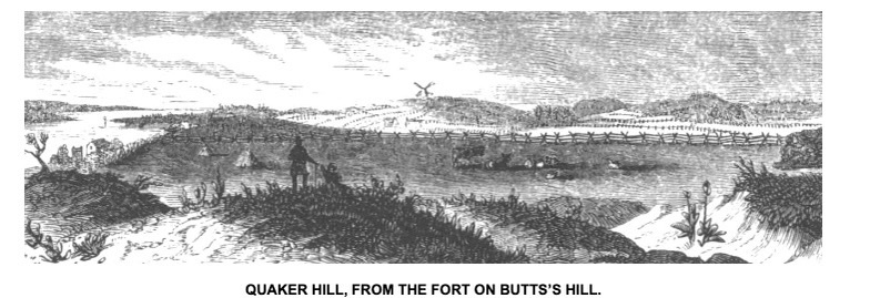
The remains of the old fort on Butts’s Hill, the embankments and fossé, with traces of the hastily-constructed ravelins, are well preserved. Even the ruts made by the carriage-wheels of the cannons, at the embrasures (for the ordnance was composed of field-pieces), were visible. The banks, in some places, are twenty feet high, measuring from the bottom of the fossé. Fortunately for the antiquary, the works were constructed chiefly upon a rocky ledge, and the plow can win no treasure there; the banks were earth, and afford no quarry for wall builders, and so the elements alone have lowered the ramparts and filled the ditches. Southward from this eminence, I had a fine view of Quaker and Turkey Hills – indeed, of the whole battle-ground.
What clues does this source give us?
- Remains of hastily-constructed ravelins (Ravelins – Ravelin: a triangular fortification in front of bastion. (Bastions are generally curved or angular in shape. This allows the soldiers to keep a watch on the approaching enemy from many directions. as a detached outwork.
- Ruts from carriage wheels of the cannons
- Embrasures visible. (Embrasures – An opening for a gun to fire through)
- Banks 20 feet high from bottom of fosse. (Fosse – ditch or moat)
- On rocky ledge
- Banks of earth,
- Elements had lowered ramparts and filled ditches. (Rampart) main defensive wall of a fortification)
- View of Quaker Hill and Turkey Hill from the south rampart.
I will work with one source at a time.