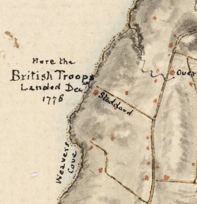
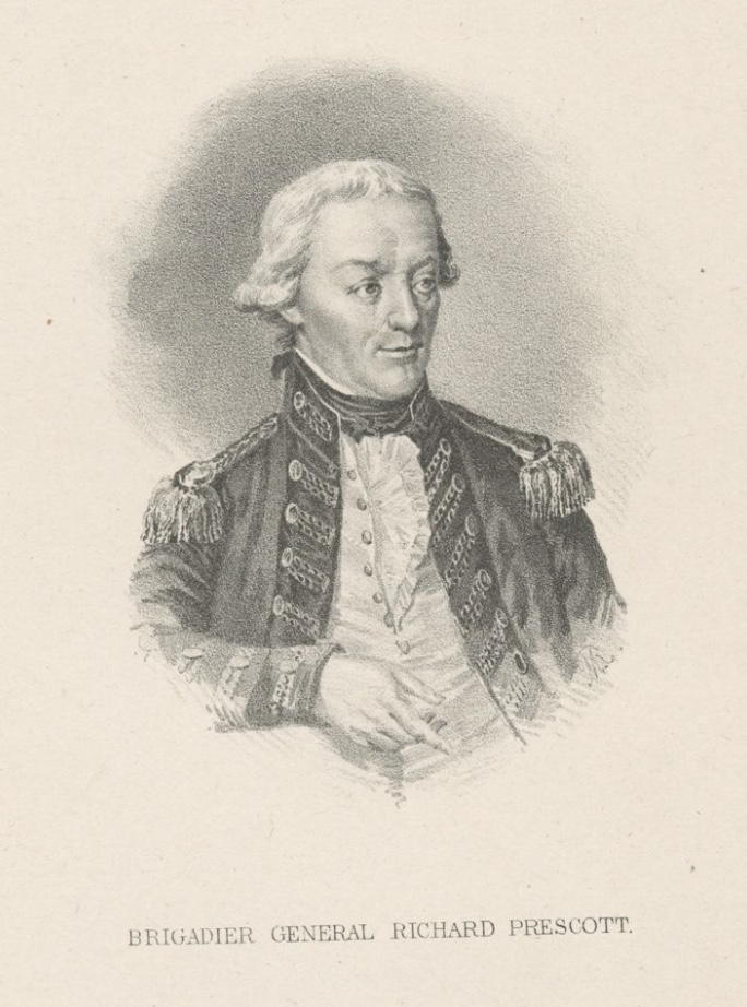
On December 8th, 1776 British General Prescott landed his troops on Aquidneck Island. They landed on the Western shore near the border of Middletown and Portsmouth at Weaver’s Cove. This was the beginning of the Occupation of Rhode Island (Aquidneck Island). The American militiamen were unable to mount a defense and they escaped by using the ferries to Bristol and Tiverton.
Fage Map
The British had ample reason to invade and occupy Aquidneck Island (called Rhode Island at that time). Newport had a fine harbor from which the British fleet could raid up and down the coast. It would enable them to blockade ships carrying supplies from abroad that were needed by the Americans.
This Occupation made the war experience different for those on Aquidneck Island harsher than those on the mainland. The Occupation lasted almost three years, ending in the fall of 1779.
The name Banister (Bannister) still exists on a popular wharf in Newport. John and his wife Christian were wealthy landowners in Newport before the coming of the Revolutionary War. Many of the land rich class in Newport became Loyalists. John’s brother Thomas even joined a Loyalist militia. John is not included on lists of Loyalists, but he and his wife were in a peculiar position once the British occupied Newport in 1776. John would ultimately sail for England to ask for reparations from the British for the damage done to his properties, but that left Christian and her young son to face life in Occupied Newport on their own. Marian Mathison Desrosiers book, The Banisters of Rhode Island During the American Revolution, provides details of Occupation life for Christian and others in Newport.
Newport was a Loyalist leaning town, so at first British occupation was not severe. Christian would have been able to go through her normal routines of shopping and visiting. Many of the merchants and tradespeople were able to continue their work. But there were hardships. Even during the first week of occupation Aquidneck Island families found their livestock confiscated to feed British troops. Island families could catch fish and hunt birds. Normal colonial trade was cut off, so Newport residents found themselves without items like wine and liquors.
As time went by there were further restrictions. Christian was distressed that she could not make some of her normal visits to family. By June of 1777 the British enclosed the Newport area with gates and citizens were required to get passes to even visit friends in Middletown or Portsmouth. The citizens lost their freedoms and their elected government. The British military was the law.
Occupation became progressively difficult and Christian and other women left alone had to deal with property loss, destruction of their orchards and trees, loss of personal freedom and lack of food and fuel. In December of 1778 British General Prescott ordered the army to cut up wood fences, old docks and boats, and even church pews to keep his soldiers warm and cook their food.
Christian’s husband remained in London for years trying to get repayment for his losses. Meanwhile, Christian hung on in Newport. In July of 1780 the French arrived. Unlike the British, the French paid for items, restored damaged homes and brought a sense of civility to Newport.
Christian’s husband returned after four years in England. She had managed to keep things going during his absence and the family benefited from her struggles. Her Loyalist brother in law Thomas lost all his property, but John and Christian did not. Eventually the Banister’s would make South Kingston their home.
Gilbert Stuart Portrait of Christian and her son John. Original at Redwood Library
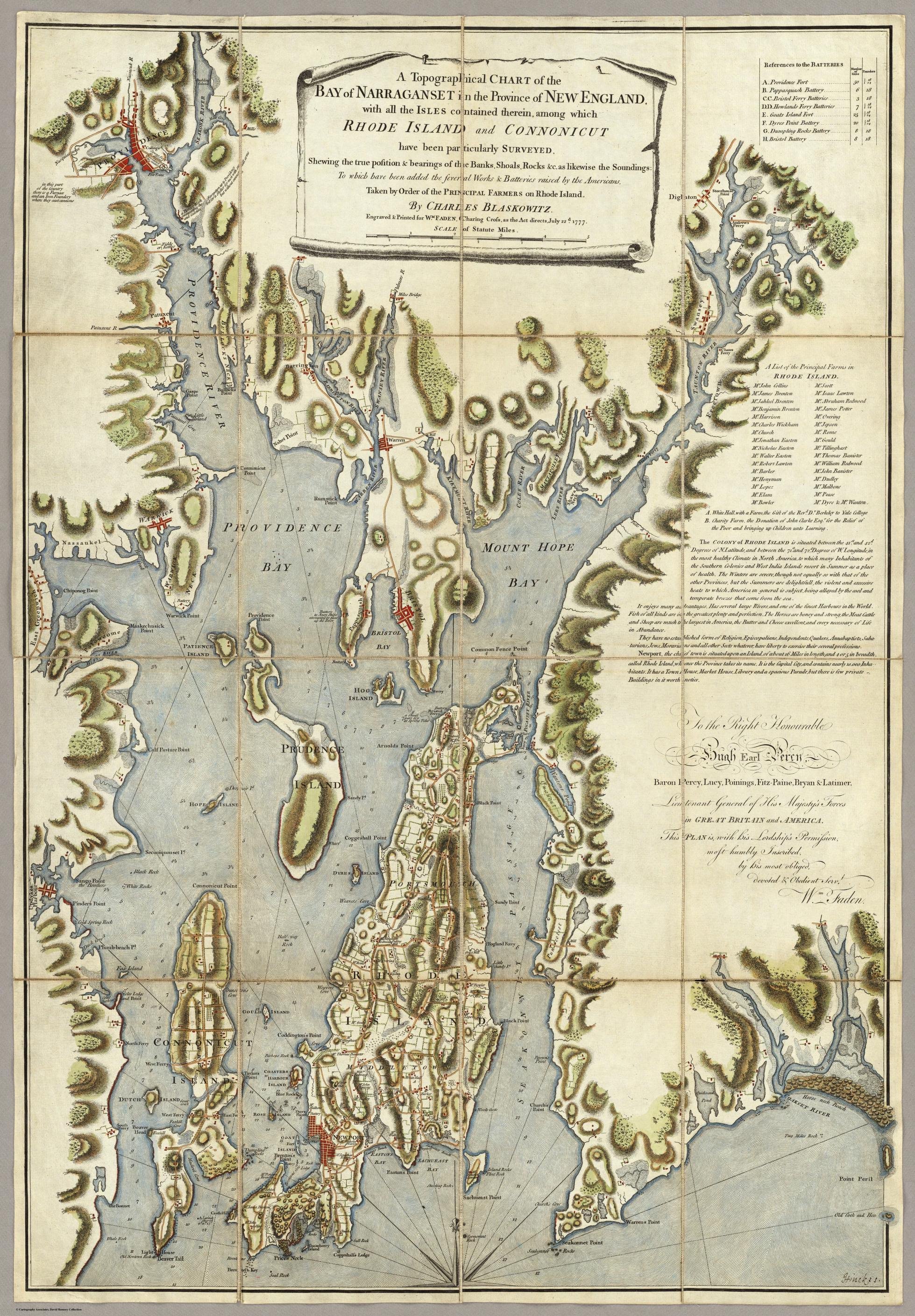
Vintage maps hold a special store of information for the local historian. I am exploring the question of what Portsmouth was like during Occupation by British forces, so I turn to one of the best resources, the Blaskowitz Map. The map is available online at the Library of Congress website. https://www.loc.gov/item/74692135/. You can download the map and zoom in to explore it in detail. Historians learn to “read” a map to extract information and I will be doing this a section at a time. In this first blog I will be taking the first step – viewing the map as a whole. I welcome my readers to view the map as well and add to what I find. I will be focused on Portsmouth, but Blaskowitz also mapped out the streets and features of Newport as well.
One of the initial questions a historian asks about a map is who created it and why. Who was Charles Blaskowitz and why did he create this particular map? He was a skillful British military surveyor. Charles was assigned by Samuel Holland in 1764 to create a chart of the coast of Rhode Island to determine if Newport would be a good harbor for a naval base. This map may have been redrawn a number of times and used for different purposes. Some suspect local farmers paid Blaskowitz to add their farms in 1771. There is a key with the names of the major farmers and their farms are plotted out on the map. Once the British occupied Aquidneck Island in 1775, some think he redrew the map in 1777 to add the British defenses for the positioning of British ships in Narragansett Bay. Batteries (groups of cannons) are included on the map and although there is no key for them, troop locations seem to be included on the island.
Portsmouth batteries are listed for Bristol Ferry with 3 18 pound guns and Howland’s Ferry with 7 guns 18 and 24 pounders. “Brittish” Batteries are also labeled on the map.
Map text reads as follows:
A Topographical CHART of the BAY of NARRAGANSET in the Province of NEW ENGLAND. with the ISLES contained therein, among which RHODE ISLAND and CONNONICUT have been particularly SURVEYED. Shewing the true position & bearings of the Banks, Shoals, Rocks &c, as likewise the Soundings: To which have been added the several Works & Batteries raised by the Americans. Taken by Order of the PRINCIPAL FARMERS on Rhode Island. By CHARLES BLASKOWITZ. Engraved & Printed for WM. FADEN, Charing Cross, as the Act directs, July 22d. 1777.
This is a “Topographical” map. It tries to be a two dimensional representation of a three dimensional earth. It shows man-made and natural features such as hills, valleys, rivers, forests, roads, bridges and other things. Blaskowitz states that he has particularly surveyed Rhode Island (Aquidneck) and Conanicut Island (Jamestown). Added to the map were the batteries which may have been a cluster of cannons. These artillery posts were “raised by the Americans.” The map includes the lands of the principal farmers of the island and there seems to be outlines of some of their farms. One thing we will do later is to find the farmers listed for Portsmouth. Often Newport merchants had their country homes and farms out in Portsmouth.
Blaskowitz goes on to describe Aquidneck Island. We get a sense of the life before the Occupation.
“The COLONY of RHODE ISLAND is situated between the 41st. and 42d. Degrees of N.Latitude, and between the 71st. and 72d. Degrees of W.Longitude, in the most healthy Climate in North America, to which many Inhabitabants of the Southern Colonies and West India Islands resort in Summer as a place of health. The Winters are severe, though not equally so with that of the other Provinces, but the Summers are delightful, the violent and excessive heats to which America in general is subject, being allayed by the cool and temperate breezes that come from the sea. It enjoys many advantages. Has several large Rivers, and one of the finest Harbours in the World. Fish of all kinds are in the greatest plenty and perfection. The horses are boney and strong, the Meat Cattle and Sheep are much the largest in America, the Butter and Cheese excellent, and every necessary of Life in Attendance. They have no established form of Religion. Episcopalians, Independents, Quakers, Annabaptists, Saba-tarians, Jews, Moravians, and all other Sects whatever, have liberty to excercise their several professions. Newport, the chief town is situated upon an Island, of about 16 miles in length, and 4 or 5 in breadth, called Rhode Island, whence the Province takes its name. It is the Capital City, and contains nearly 10,000 Inha-bitants. It has a Town House, Market House, Library and a spacious Parade, but there is few private Buildings in it worth notice.”
What does he tell us about life before the War for Independence?
Aquidneck Island had a temperate, healthy climate that attracted Southern people as a summer resort.
The island had large rivers and one of the finest harbors in the world. That would be in Newport, not Portsmouth.
Fishing was plentiful.
Farmers were raising horses, cattle and sheep. The livestock was among the best in America.
Farmers produced excellent butter and cheese.
There is no established religion, so people “have liberty to exercise” their faith.
In trying to understand what happened to Portsmouth during the British Occupation it is important to have an idea of the town before the War. The Blaskowitz Map details life on Aquidneck Island before the Occupation. Even though the date of engraving was 1777, the surveying was done much before that. Exploring this map provides the clues to understanding all that Portsmouth had to lose once it was occupied.