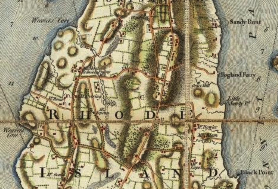
What does the Blaskowitz Map tell us about Portsmouth in the days before the War for Independence? We continue our exploration of the map south of Sprague Street.
What features are marked on the map?
Natural features:
There are two points labeled “Black Point.” One is in the Newtown area and the other is what we call “Black Point” today. “Sandy Point” is what our modern day McCorrie Point is labeled. “Little Sandy Pt.” is our Sandy Point beach area today. Coggeshall Point and Arnold’s Point are on the map. There are two Weaver’s Coves – one in Portsmouth and one at Middletown. The Cove in Portsmouth is by the entrance to Lawton’s Valley.
Man-made features:
There is a Tavern around East Main and Dexter Street. The 1700 Quaker Meeting House is on the map. During the Occupation it was used to house British troops and ammunition was stored in the basement. A fulling mill (to wash and dress wool) was located off of Union Street in the Lawton area. Fogland Ferry is off of Glen Road and heads across to Tiverton. A grist mill (to grind grain) is located within the Glen. Butts Hill is not labeled, but there seems to be troops located there. The orderly rows of dots around the Butts Hill area and to the south of what would be McCorrie Lane today suggest Patriot reinforcements. Blaskowitz’s text mentions that he has included works and batteries raised by the Americans. The location between McCorrie Lane and Glen Road would be a defense against invasion from across the narrow strait of Fogland Ferry. We know that Hessian troops were encamped around there during the Occupation.
Quaker Meeting House
circa 1700
Roads: These are listed with the modern names because Blaskowitz did not label the roads.
Dexter Street, Power St. (heading to “Black Point”), Hedley Street, Freeborn Street, Church Lane, Middle Road, Mill Lane, Stub Toe, School House, Locust Avenue, East Main, West Main, Braman’s Lane, Mitchell’s Lane, Union Street, Jepson Lane, part of Sandy Point Ave.
Neighborhoods: Where are the homes distributed?
Newtown area on East side, West Main Road has clusters, South Portsmouth (Wapping Road area) has a number of homes. East Main Road from Quaker hill to Union has dwellings as does Union Street itself.
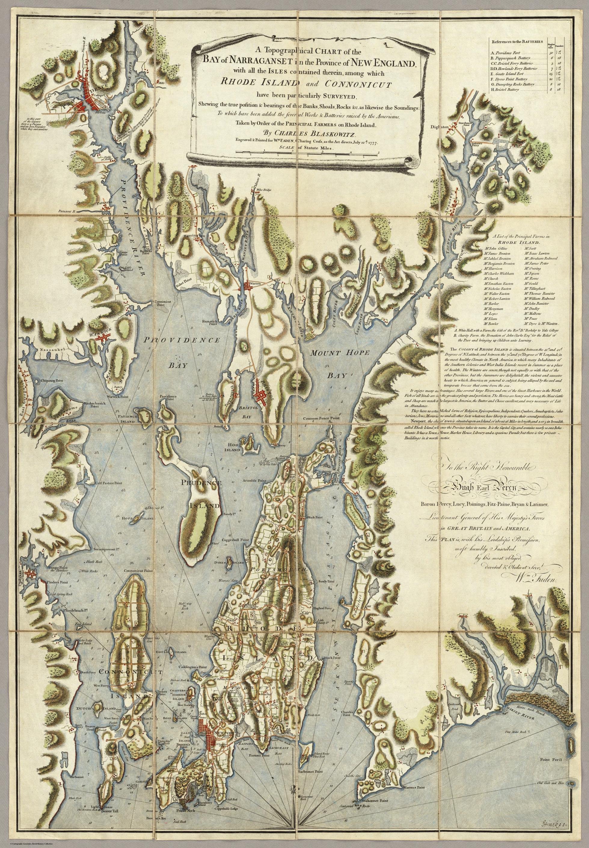
One line in the text of Blaskowitz’s Map leads us to believe that Aquidneck Island farmers may have ordered this edition of the map. “Taken by Order of the PRINCIPAL FARMERS on Rhode Island.” So who were these farmers whose farms were listed on the map? The stories of these men tell us a great deal about Portsmouth in the days before the War for Independence. They demonstrate the interconnectedness of Portsmouth to the Newport commerce and society. Portsmouth’s “gentleman’s farms” did not start with the Vanderbilts and Taylors, they started back in colonial times. Newport merchants and slave ship owners had their business and house in Newport, but they also had their country farm in Portsmouth. This blog will provide a short sketch of the farmers and their backgrounds. This is the first of the blogs on the topic of these “farmers.”
Blaskowitz Map of South Portsmouth
Metcalf Bowler: Wapping Road:
Hidden among the papers of Sir Henry Clinton, the British Commander during the American Revolutionary War, was the story of a well known Portsmouth farmer and Newport merchant who played the role of spy. The spy was none other than Metcalfe Bowler whose farm was on Wapping Road. Metcalf Bowler did an excellent job of hiding his spy activities. He was an important man in the Rhode Island Colonial government. When Rhode Island decided to become independent from Great Britain, Bowler was one of the men who signed the document that would be sent to the king.
Among the letters to Clinton was one dated Dec 12, 1776 from Portsmouth. Bowler (writing as “Rusticus”) claims that even though he has accepted government positions (such as Chief Judge) in the American side of the war, he is still acting loyally to the British king. He begs for protection for his home in Portsmouth. “As the Hessian troops quartered on the island …having committed many outrages…on many of the inhabitants by entering their Houses and …even putting them in fear of their lives – as I am situated on the Island, should esteem it a favor …if your excellency would order a guard to my habitation (house) at Portsmouth that I may be protected from the insults of the Hessians.” This letter may give a clue to why Bowler would work as a spy. He wanted his home protected.
Unfortunately Bowler’s farm was damaged just as much as the surrounding farms. His letter provides a first hand report of the damage done to Portsmouth farms during the occupation by British troops. There was great fear of the Hessian troops that were camped in Portsmouth. In a later letter he wants money for the damage to his property. His home and garden in Newport were used as a British hospital. His Portsmouth farm was damaged, his cow was taken to feed the soldiers, his library books were stolen and his cart and horses were taken away. They were not able to grow any crops during the time the British held the island. “I shall not be able to support my self and family on the Island through the approaching dismal winter.” He asks the British for protection for himself, his family and his black servant. Bowler’s letter gives us an excellent example of what happened to Portsmouth farms during the Occupation.
Bowler’s Home on Wapping Road
Gervais Elam: Wapping Road
When we hear the name Elam we might think of Samuel Elam and Vaucluse Farm. Before the War for Independence, it was Gervais Elam, his uncle, who owned the property. Gervais was from Leeds, England. He was considered an “eminent clothier.” When he died in 1784 his nephew Samuel put the property up for sale. This advertisement gives us a wonderful idea of what the farm was like in Gervais’ day. Note that the ad suggests it is a good spot for someone to retire from business and “recover the effects of long residence in war and sultry climates.”
Newport Mercury 1785 June 4th
On the 15th day of August next, will be sold at public venue, in the city of Newport, when the terms of sale will be made known. Possession to be given in the month of march next.
The valuable farm and country seat at Portsmouth, Rhode Island late belonging to Gervais Elam, deceased, containing about 150 acres of excellent land, suitable for meadows, pasture or grain on which is a fine young Apple Orchard. It lies on a public road, five miles from Newport, adjoining to land late belonging to Metcalf Bowler, Esq.; and upon the sea or sound called the Secunnet Passage- having a gradual descent to the water.
The buildings are in good order and consist of a large new built frame house, two stories high having a spacious passage and four rooms on one floor with col(?) and garrets complete, and suitable out buildings- the whole is situated on an eminence which commands a pleasingly varied and extensive prospect over a beautiful wooded Country bounded by the ocean.
A considerable stream of fresh water runs through the middle of the farm, which has fall sufficient to rend it capable of being converted to the most useful purposes, and in a peculiar manner of those of elegance and pleasure – while its boundary on the sea affords, besides the conveniences of fishing and water carriage, the real advantage during most winters, of having a quantity of sea-weed thrown upon the shore more than sufficient to Manure the whole. These advantages added to the pleasant and healthy situation of this far in to open and airy a part of the island renders it an eligible spot for those who wish to retire from business or recover the effects of long residence in the warm and sultry climate of the West Indies or southern states.
John Jepson: Jepson Lane
Jepson’s farm was located by Portsmouth/Middletown on what we know as Jepson’s Lane. He was a statesman who represented Portsmouth in colonial government as a Senator, Deputy and Judge. He was an assistant to the Governor and the General Assembly in 1776. It was difficult to find much information on him, but several sources list him among the Newport slave traders. He was one of the founding members of the “Fellowship Club” in 1752 that was an association of many of the captains of slave ships.
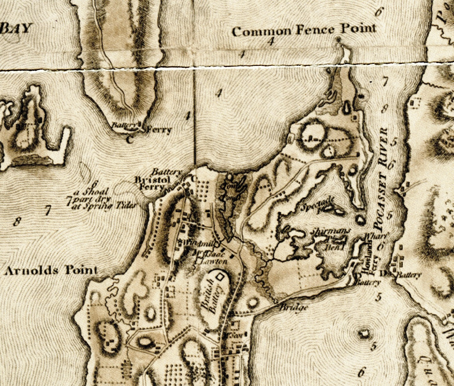
In reading a map for information, it helps to view the map in smaller sections to pull out the information. I am focusing on the Northern portion of the town – basically Sprague Street and north. As I view the map I try to put elements into categories. I encourage my readers to view the map and let me know what they see that I have missed.
Transportation -Roads
Looking at today’s map as well as the Blaskowitz Map, these are the roads I see. Blaskowitz does not label the roads, so I will use today’s labels
Park Avenue which would head toward the Howland Ferry
Bristol Ferry Road which would head toward the Bristol Ferry
Part of Boyd’s Lane
Sprague Street
Child Street
Anthony Road
East Main Road
West Main Road
Water Street
Transportation: Ferries
Bristol Ferry which was the main route to Bristol and the North
Howland Ferry which was the main route to Tiverton and Massachusetts to the East
Military Sites: Batteries
Blaskowitz noted where Americans had placed defenses before the Occupation, but he also includes British battery along East Main Road to the north of Sprague Street.
Howland Ferry Battery: This is an important place for the Americans who used this narrow area as a point to move their troops onto the island and when the battle was done to escape off the Island to Tiverton and the safety of Fort Barton.
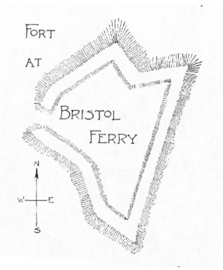
Bristol Ferry Battery: Edward Field’s paper on Revolutionary Defenses a diagram of the Fort at Bristol Ferry. See Reference below.
Farmers and Farms
Mr. Scott’s farm was located between Child Street and Park Avenue. I could not find information on Mr. Scott, but he may have been a Newport merchant and or Captain who had a country farm in Portsmouth. He was not included in the 1778 tax roll.
Isaac Lawton’s farm was located around East Main Road heading toward Boyd’s Lane. Isaac is active in the Quaker church. After the War for Independence many Quakers began to give up their slaves and Isaac’s widow, Mary Fish Lawton, was among those who freed her slave.
Geographic Features
To the East: Common Fence Point, Spectacle Island, Sherman’s Point, Hen Island, Town Pond, Pocasset River
To the West: Arnold’s Point, Shoal by Bristol Ferry that is part dry at Spring Tides
Man-Made Features
To the East: Bridge by Park Avenue, Wharf by Howland Ferry
To the West: Windmill by Bristol Ferry Road
Distribution of Homes
Where did Portsmouth residents live? In this section of the map there are two basic communities. The largest collection of homes was in the Bristol Ferry Road neighborhood. This was one of the earliest areas established when the original land grants were given out. This would have been a high volume transportation route, so there were accommodations for travelers, taverns and other commercial properties here. The second community seems to be in what is called the Newtown area around Child Street and between East Main Road and Water Street. This was an area established when the Town Pond became silted up in 1728 and the original settlement around Anthony Road were abandoned.
Resources Used:
REVOLUTIONARY DEFENCES IN RHODE ISLAND AN HISTORICAL ACCOUNT OF THE FORTIFICATIONS AND BEACONS ERECTED DURING THE AMERICAN REVOLUTION, WITH MUSTER ROLLS OF THE COMPANIES STATIONED ALONG THE SHORES OF NARRAGANSETT BAY BY EDWARD FIELD PAST PRESIDENT OF THE RHODE ISLAND SOCIETY OF THE SONS OF THE AMERICAN REVOLUTION WITH MAPS, PLANS, AND ILLUSTRATIONS PROVIDENCE, R.I. PRESTON AND ROUNDS 1896
Vintage maps hold a special store of information for the local historian. I am exploring the question of what Portsmouth was like during Occupation by British forces, so I turn to one of the best resources, the Blaskowitz Map. The map is available online at the Library of Congress website. https://www.loc.gov/item/74692135/. You can download the map and zoom in to explore it in detail. Historians learn to “read” a map to extract information and I will be doing this a section at a time. In this first blog I will be taking the first step – viewing the map as a whole. I welcome my readers to view the map as well and add to what I find. I will be focused on Portsmouth, but Blaskowitz also mapped out the streets and features of Newport as well.
One of the initial questions a historian asks about a map is who created it and why. Who was Charles Blaskowitz and why did he create this particular map? He was a skillful British military surveyor. Charles was assigned by Samuel Holland in 1764 to create a chart of the coast of Rhode Island to determine if Newport would be a good harbor for a naval base. This map may have been redrawn a number of times and used for different purposes. Some suspect local farmers paid Blaskowitz to add their farms in 1771. There is a key with the names of the major farmers and their farms are plotted out on the map. Once the British occupied Aquidneck Island in 1775, some think he redrew the map in 1777 to add the British defenses for the positioning of British ships in Narragansett Bay. Batteries (groups of cannons) are included on the map and although there is no key for them, troop locations seem to be included on the island.
Portsmouth batteries are listed for Bristol Ferry with 3 18 pound guns and Howland’s Ferry with 7 guns 18 and 24 pounders. “Brittish” Batteries are also labeled on the map.
Map text reads as follows:
A Topographical CHART of the BAY of NARRAGANSET in the Province of NEW ENGLAND. with the ISLES contained therein, among which RHODE ISLAND and CONNONICUT have been particularly SURVEYED. Shewing the true position & bearings of the Banks, Shoals, Rocks &c, as likewise the Soundings: To which have been added the several Works & Batteries raised by the Americans. Taken by Order of the PRINCIPAL FARMERS on Rhode Island. By CHARLES BLASKOWITZ. Engraved & Printed for WM. FADEN, Charing Cross, as the Act directs, July 22d. 1777.
This is a “Topographical” map. It tries to be a two dimensional representation of a three dimensional earth. It shows man-made and natural features such as hills, valleys, rivers, forests, roads, bridges and other things. Blaskowitz states that he has particularly surveyed Rhode Island (Aquidneck) and Conanicut Island (Jamestown). Added to the map were the batteries which may have been a cluster of cannons. These artillery posts were “raised by the Americans.” The map includes the lands of the principal farmers of the island and there seems to be outlines of some of their farms. One thing we will do later is to find the farmers listed for Portsmouth. Often Newport merchants had their country homes and farms out in Portsmouth.
Blaskowitz goes on to describe Aquidneck Island. We get a sense of the life before the Occupation.
“The COLONY of RHODE ISLAND is situated between the 41st. and 42d. Degrees of N.Latitude, and between the 71st. and 72d. Degrees of W.Longitude, in the most healthy Climate in North America, to which many Inhabitabants of the Southern Colonies and West India Islands resort in Summer as a place of health. The Winters are severe, though not equally so with that of the other Provinces, but the Summers are delightful, the violent and excessive heats to which America in general is subject, being allayed by the cool and temperate breezes that come from the sea. It enjoys many advantages. Has several large Rivers, and one of the finest Harbours in the World. Fish of all kinds are in the greatest plenty and perfection. The horses are boney and strong, the Meat Cattle and Sheep are much the largest in America, the Butter and Cheese excellent, and every necessary of Life in Attendance. They have no established form of Religion. Episcopalians, Independents, Quakers, Annabaptists, Saba-tarians, Jews, Moravians, and all other Sects whatever, have liberty to excercise their several professions. Newport, the chief town is situated upon an Island, of about 16 miles in length, and 4 or 5 in breadth, called Rhode Island, whence the Province takes its name. It is the Capital City, and contains nearly 10,000 Inha-bitants. It has a Town House, Market House, Library and a spacious Parade, but there is few private Buildings in it worth notice.”
What does he tell us about life before the War for Independence?
Aquidneck Island had a temperate, healthy climate that attracted Southern people as a summer resort.
The island had large rivers and one of the finest harbors in the world. That would be in Newport, not Portsmouth.
Fishing was plentiful.
Farmers were raising horses, cattle and sheep. The livestock was among the best in America.
Farmers produced excellent butter and cheese.
There is no established religion, so people “have liberty to exercise” their faith.
In trying to understand what happened to Portsmouth during the British Occupation it is important to have an idea of the town before the War. The Blaskowitz Map details life on Aquidneck Island before the Occupation. Even though the date of engraving was 1777, the surveying was done much before that. Exploring this map provides the clues to understanding all that Portsmouth had to lose once it was occupied.