Would the Southermost School have been witness to the early skirmishes in the Battle of Rhode Island?
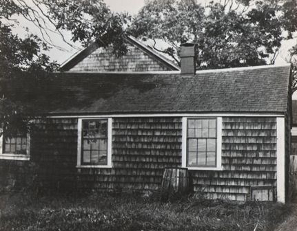
Southemost School before restoration
The Southermost School traveled up and down Union Street. Where was it located at times?
With the coming celebration of the 300th Anniversary of the Southermost School, I am revisiting the information I have gathered in the past. Maps, histories, and documents help us to answer those questions.
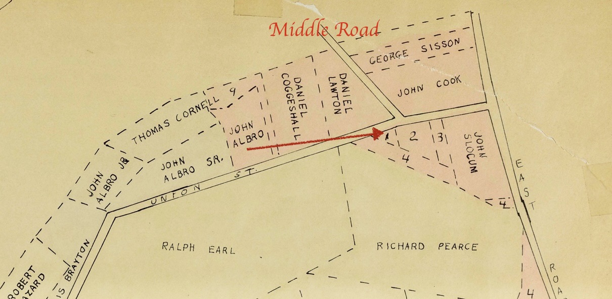
According to Portsmouth historian Edward West in his History of Portsmouth 1638-1936, in August of 1716 a school won approval at the Town Meetings. It was to be located on public land between Child Street and Church Lane. The other was approved on September 10th. It would be build on land donated by William Sanford. This was a small triangluar shaped parcel granted to him in 1713. West’s land grant maps help us visualize the location.
I have placed an arrow pointing to this piece of land Sanford Donated. It was labeled as 1. It is on the south side of Union Street and just past Middle Road.
The Portsmouth Historical Society today would be in part of the land of John Cook.
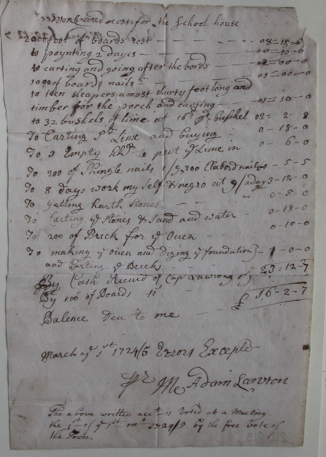
It took nine years for the school to actually be built. The Portsmouth Historical Society has a copy of the bill.
This document gives us some interesting details about what the schoolhouse looked like in its original form.
It had an oven made of 200 bricks. It had a stone hearth. Adam Lawton and a “negro” worked for 8 days on the building. It was completed in March 1725. It is listed as 24/25 because of the change over in the calendar. There was a porch. Lots of lime was used in the building. It took 2 days to paint. Some of the boards were as long as 30 feet.
This blog is one of a series on historical and recreational lands owned by the Town of Portsmouth. We (the Portsmouth Conservation Commission and I) hope that October will be a month when Portsmouth residents will visit and enjoy the properties they own as taxpayers.
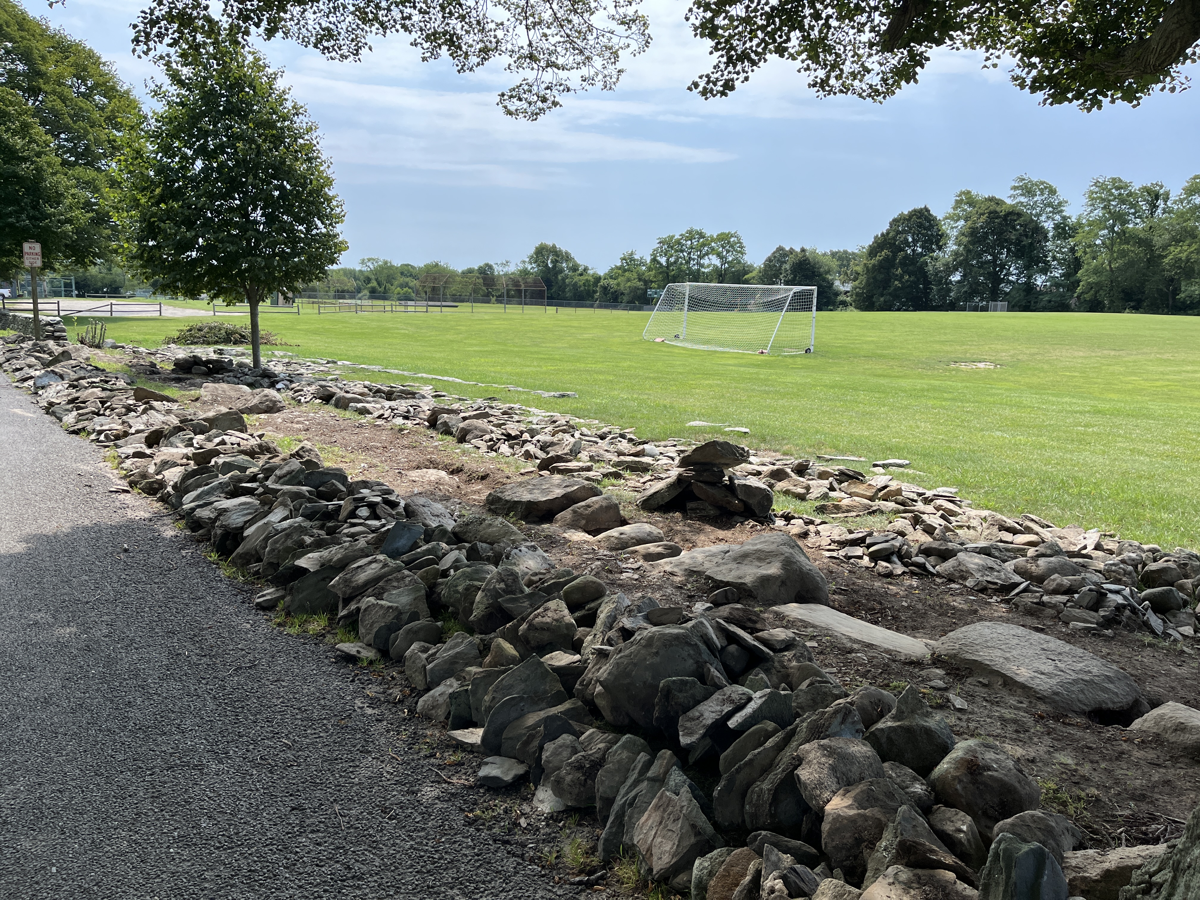
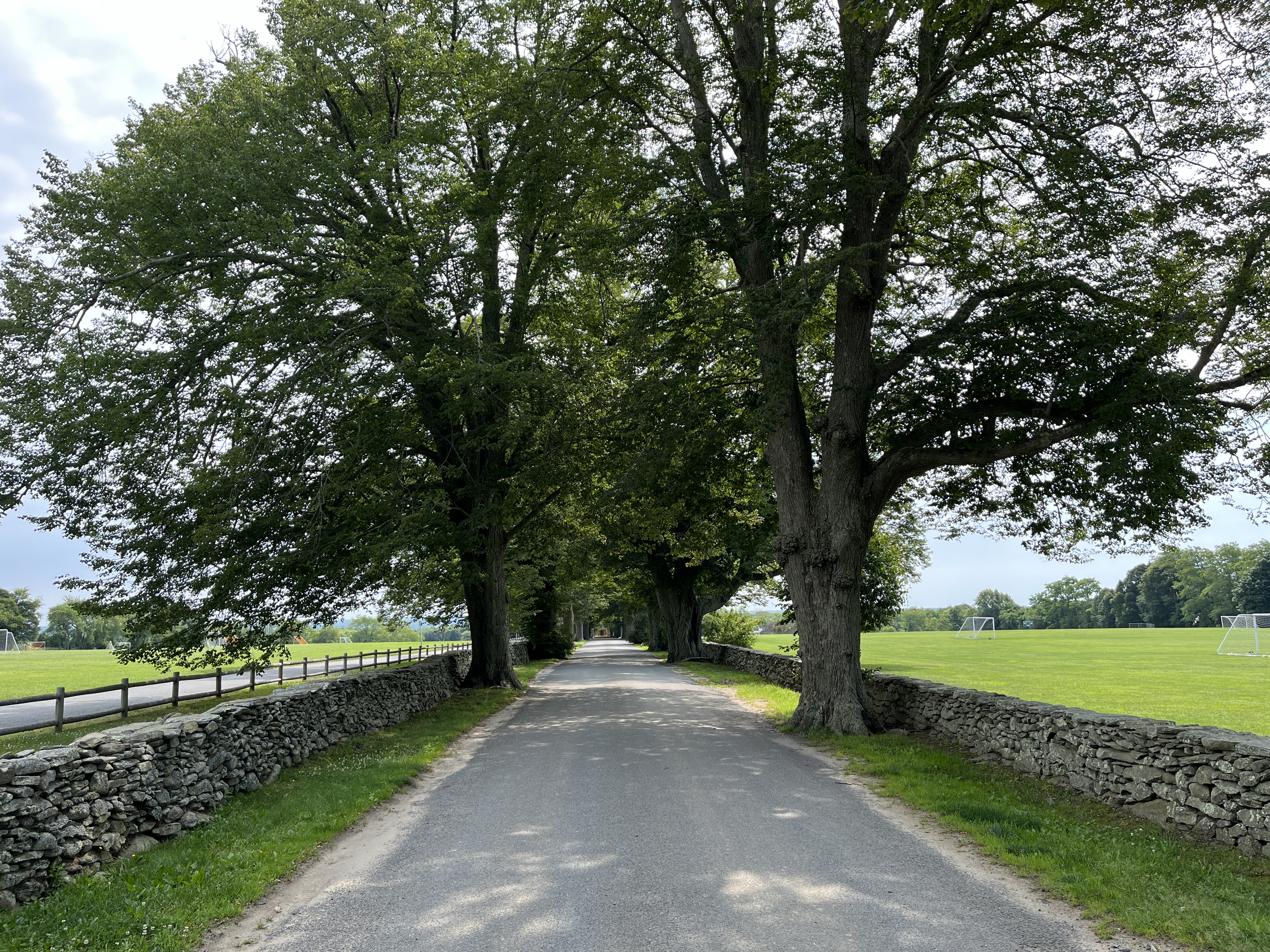
As you drive down Linden Lane through the Gardner Seveney Sports Complex, you will notice a golden yellow house at the end of the row of trees. This is the Brown House, the Leonard Brown House. It is newly restored and is the home of Portsmouth’s Parks and Recreation Department. It is a useful house, because twenty years ago an organization (Friends of Leonard Brown House) worked to save it and the town finished the process to restore it.
These recreational fields were once part of the property grants of John Cooke. It was passed down to Cook Wilcox who was part of Portsmouth’s militia in the Revolutionary War. After Wilcox died the property came into the ownership of Leonard Brown through his wife, Sarah Wilcox Brown.
Who was Leonard Brown? Brown was considered one of the best farmers in Portsmouth. He raised poultry and pigs and brought them to market in New Bedford. Along with farming, Brown served as a wheelwright and a blacksmith. Leonard Brown represents the Yankee farmers, the descendants of the original English settlers. Brown and the farmers like him were the backbone of Portsmouth. They served in political offices, farmed and were the skilled craftsmen of the town.
When Leonard Brown died in 1896, the Brown farm was sold to H.A.C. Taylor and became part of the Glen Farm. It was always painted yellow because the Taylor’s chose that color for their Glen Farm buildings.
Location: From East Main Road take a turn onto Linden Lane. There is a new traffic light at that corner. There is parking by the soccer fields to the right as you drive down Linden Lane and also parking by the Brown House.
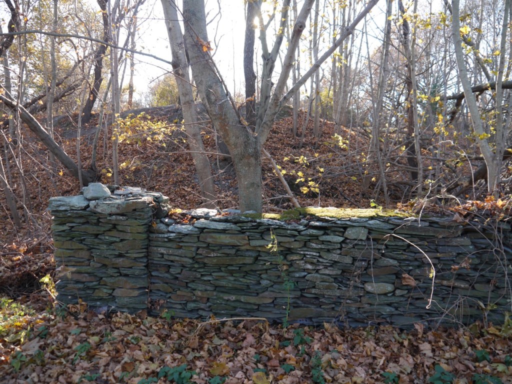
Activities: For the casual walker or dog walker, Linden Lane is ideal. The trees provide shade in summer and the road is paved. The walk from the top of Linden Lane to the “Red Cross” house and back is a little over a mile. Right now you can watch the reconstruction of the stone walls along the way. The setting at Brown House – house, stone wall, flowers and trees – is ideal for sketching or painting.
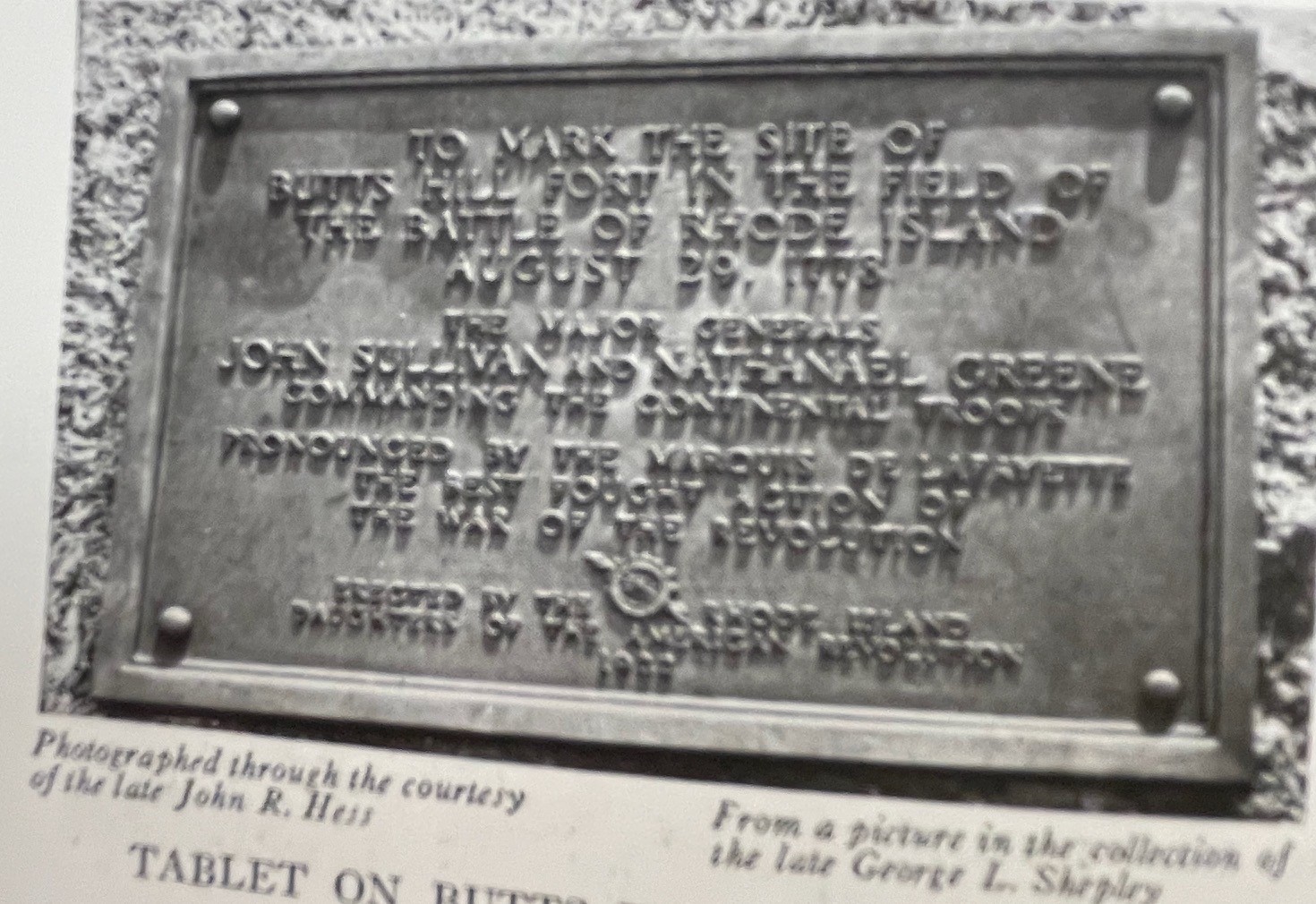
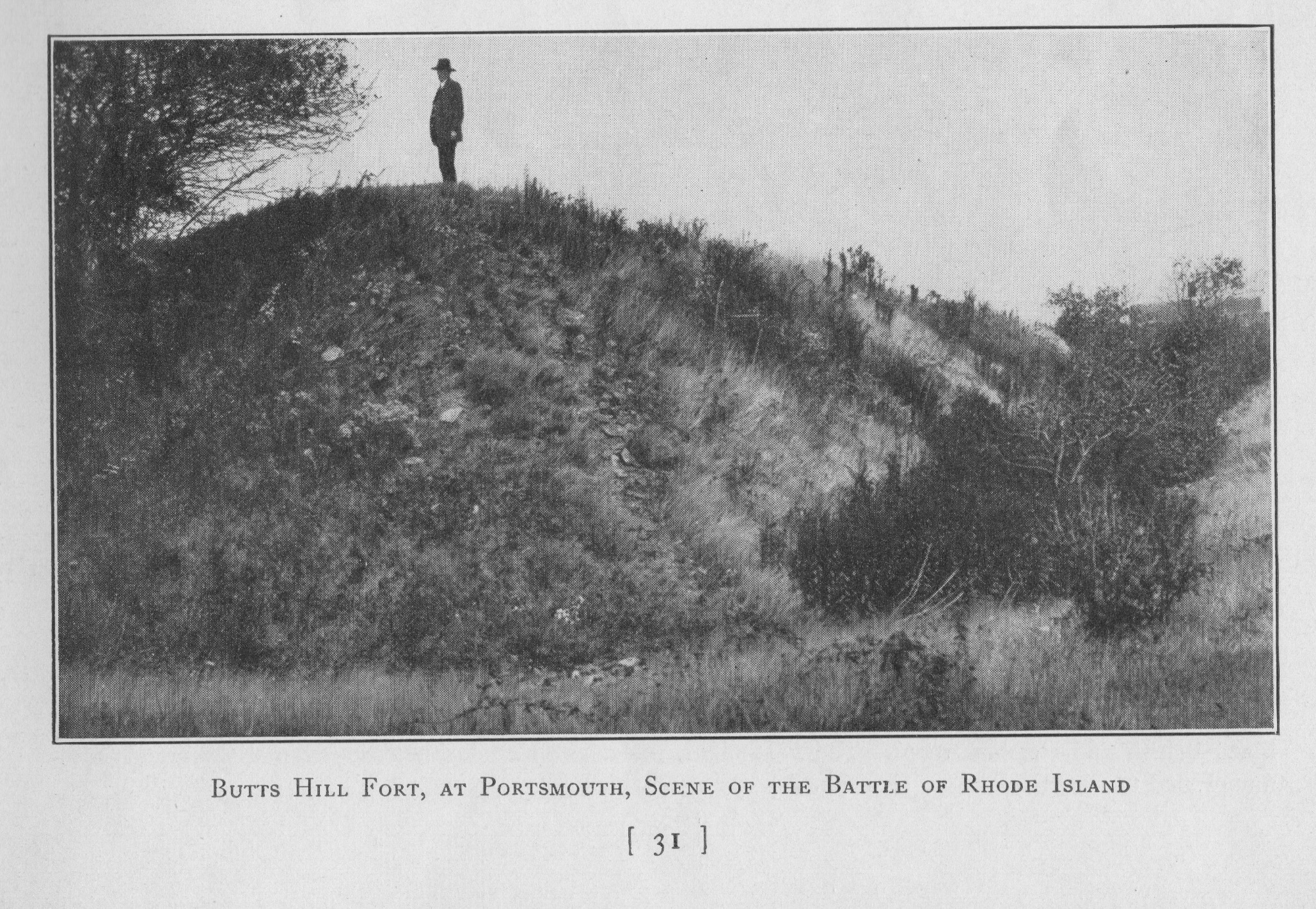
In a corner of Butts Hill Fort there is a boulder that obviously once held a plaque. The Butts Hill Fort Restoration Committee is diligently working on clearing the area around the boulder and there are hopes of restoring the plaque or making a facsimile to restore the memorial to its intended tribute. Today the original memorial is damaged and in the protective custody of the Portsmouth Historical Society. We know what it looked like in its prime.
A 1925 book “France and New England” by Alan Forbes and Paul Cadman, prominently mentioned the plaque and features an image of it. (1)
“Butts Hill Fort, on the east road between Tiverton and Newport and in the township of Portsmouth, on the north end of the island of Rhode Island, has been permanently associated with Lafayette by placing at the southeast corner of the earthworks a native boulder, on the face of which is a bronze tablet, the inscription reading as follows:
To mark the site of
Butts Hill Fort in the Field of the Battle of Rhode Island
August 29, 1778
The Major General
John Sullivan and Nathanael Greene
Commanding the Continental Troops
Pronounced by the Marquis De Lafayette
The Best Fought Action of
The War of the Revolution
Erected by the Rhode Island
Daughters of the American Revolution
1922
Even before Rev. Roderick Terry purchased the land that encompassed Butts Hill Fort, the Daughters of the American Revolution (D.A.R.) were honoring the fort on the one hundred and forty-fourth anniversary of the Battle. Newspaper accounts at the time report that two hundred and fifty people gathered on August 29, 1922 to unveil a tablet that “commemorates the battle on August 29, 1778 when sturdy Americans under Gen. John Sullivan fought the best planned battle of the Revolution.” (2)
The unveiling drew members of the D.A.R. from all “corners of Rhode Island and neighboring states.” (Newport Mercury). Other organizations took part in the ceremonies as well. Portsmouth Girl Scouts gave the bugle call and sang the “Star Spangled Banner.” Invitations were sent to the Sons of the American Revolution, Rhode Island Historical Society, Newport Historical Society, Rhode Island Citizens Historical Society, Bristol Train of Artillery, Sons and Daughters of the Puritans and Quequechan Chapter from Fall River. The public was invited to attend. (3)
After the unveiling, prayers and speeches, the guests were treated to a basket lunch at the Sprague Street home of Mrs. D. Frank Hall. It was the Hall family that owned the fort property before Rev. Terry bought it and put it into the care of the Newport Historical Society.
The Lafayette quote “The best fought action of the War of the Revolution” intrigued me because I have been researching the Marquis’ role in the Rhode Island Campaign. This quotation is widely attributed to Lafayette, but I could not find a confirmation in any of his letters of the time. Lafayette missed most of the action in the Battle of Rhode Island because he was sent to Boston to persuade the French fleet to come back to Newport. He did however, lead the last of the American troops to safety in Tiverton. He greatly admired Sullivan’s skill in executing a well planned retreat.
Sources:
Forbes, Aland and Paul Cadman. The French in New England. Boston, State Street Trust, 1925.
Long ago I was asked to research what buildings date from the time of the War for Independence. I put this driving tour together after I had done the research, but it was never used. With the renewed interest in Butts Hill Fort and all things Revolutionary, I’m including it in my blog in hopes it is useful. Please let me know if I need to update information. There is already one house I had to eliminate because it was torn down to make way for a housing development.
Portsmouth Revolutionary Heritage Trail
In the mid 17th century there were two roads laid out – East Main and West Main Roads. Each was a path toward ferries. West Main headed towards the Bristol Ferry and East Main led to the Howland Ferry to Tiverton. Most of the old houses and sites grouped around East or West Main and the roads around the other ferries. There was a cluster of buildings around the way to the Bristol Ferry and on Glen Road towards the Fogland Ferry to Tiverton.
Dating many of the old homes is very difficult. Many homes have a small part of the Revolutionary Era building as part of the house, but much of the home was added on later. Many of the “named homes” bear the names of families who owned the house much after the Revolutionary era.
Beginning at the Middletown Border on West Main Road.
Nichols -Overing House (Prescott Farm)
The Newport Restoration Society which now conserves this property dates this house to 1730. – In July of 1777, an American force of forty men, led by Colonel William Barton, captured General Prescott here. It was one of the boldest and most hazardous enterprises of the American Revolution. General Prescott was later exchanged for the American Major General Charles Lee.
At this site you can also see some Revolutionary era structures which have been relocated to what is called Prescott Farm today.
Guard House: This small gambrel-roofed building was attached to the back of the Nichols–Overing House in 1840. Oral tradition has it located on the site in the 1700s and its frame is certainly 18th century.
The Hicks House: This house dates from around 1715 and was moved from Bristol Ferry Road, Portsmouth to its present location in 1970. It is thought to have been used, in its earliest period, by the ferrymen who operated the boat between Portsmouth and Bristol at the site of the current Mt. Hope Bridge. It is a very simple structure of two rooms and a loft space.
Sweet-Anthony House. Originally located at 855 West Main Road, this house was moved to Prescott Farm in 1970. This broad-gable roofed 1½ story farmhouse came with much original woodwork intact. It is a good example of simple rural architecture, complete with additions which were made in the 18th and 19th centuries.
Proceed up West Main Road past Raytheon. At the crest of the hill on the right is Locust Avenue,
Steven Watson House, 98 Locust. Right side of house dates to about 1760 – main part is 1835. This is a private home.
Heading North on West Main Road,
Farther to the north, on the heights of Turkey Hill, was the Hessian stronghold during the Battle of Rhode Island. This was at the intersection of West Main Road with Hedly Street. There is a northern overlook of the battlefield on Capillary Way (off Hedly St.). As you continue north from Turkey Hill on Rte. 114 (still West Main Road) there is a short section of the original Hessian route to the west.
Henry Hedley House. 234 Hedly Street. 1730. Hedley family farmhouse.: It is set back from the road on Maplewood Farm. Private Home.
Heading North on West Main Road, Cory’s Lane is to the left after Hedly St.
Seth Anthony House is on the grounds of Portsmouth Abbey. Built around 1740. The house, at the end of a long lane behind Portsmouth Abbey School, was in the middle of the Battle of Rhode Island in 1778 and was plundered by Hessian soldiers.
Return to West Main and Travel North
Follow the new highway down the north face of Turkey Hill, and where Rte. 24 begins, swing left to follow Rte. 114. Note the Battle of Rhode Island marker on the left. The monuments reads: “Bloody Run Brook, First Black Militia, R. Island Regt., August 29, 1778. In honor of the first Black slaves and freemen who fought in the Battle of Rhode Island as members of the First Rhode Island Regiment The Black Regiment.”
Continue north on Rte. 114, up LeHigh Hill. As the road curves around to the east, there is a western overlook for the area of heaviest fighting in the Battle of Rhode Island. West Main Road ends at the intersection with Turnpike Avenue (to the south), Bristol Ferry Road (to the north/Rte. 114 continued), and Sprague Street (to the east). Continue straight (east) onto Sprague Street, which skirts the north slope of Butts Hill. Turn right (south) onto Butts Street, go part way up the hill, and park along the side of the road near the water tower. Please be sensitive to the fact that this is a congested residential area. Walk into the fort along the dirt road by the water tower, and enter the center of the park through the gap in the earthwork walls next to the granite marker. From here you can walk around the fort to get a sense of the outlines of the walls.
History of Butts Hill Fort
In 1776 the Americans built a small battery on Butts Hill (also called Windmill Hill), the highest ground on north Aquidneck Island. The British and Hessians occupied the fort in December 1776 and later built a barracks nearby for 200 men, which then was connected to the earthwork. Butts Hill Fort is the largest extant Revolutionary War structure in Rhode Island.When the Americans abandoned their unsuccessful Siege of Newport in August 1778, they established their lines around Butts Hill. During the Battle of Rhode Island on August 29-30, the fort was the American stronghold and the whole battlefield could be seen from its heights. The British returned to Butts Hill when the American troops withdrew to the mainland, and in 1780, after the British abandoned Rhode Island, French troops were also there. Following the close of the war, Butts Hill was not congenial for farming, so the earthwork remained virtually intact. In 1909, local preservationists worked to save the earthwork from 200 platted house lots, and Butts Hill Fort opened as a park in 1923. Although the earthwork is now heavily overgrown and there has been some erosion, the fort’s dramatic features are clearly identifiable. The open area in the center, once graded for playing fields, is now very muddy. The access road and walking paths around the earthwork’s eastern perimeter are also rough and muddy. Despite intermittent attempts to manage the park, it is subject to vandalism. For instance, there is evidence of illegal artifact-hunting, the early signage has disappeared, and the large granite marker at the entrance is intermittently “tagged” (paint vandalism). In partnership with the Town of Portsmouth, the Butts Hill Fort Committee plans for Butts Hill Fort include proper parking away from the residential area, removal of the intrusive vegetation, trail improvement, creation of viewscapes, installation of signage, development of an interpretive center, and a continuing presence to deter further damage to Rhode Island’s most important Revolutionary War site.
Return West on Sprague Street to West Main Road. Turn left at Turnpike Ave/Bristol Ferry Road
Brownell Ashley Grant House 24 Bristol Ferry Road. Probably 1750. Moved from Melville area.
Gifford Inn. 531 Bristol Ferry Road. Gifford House c. 1750; Portsmouth Town Records show that in 1775 David Gifford had a license for an inn. David Anthony and Benjamin Hall were listed as the “gentlemen” for the public house. David Gifford was active in the local militia during the Revolution.
Proceeding north on Bristol Ferry Road to the water.
Bristol Ferry area. This is a historic landscape/seascape even though the ferry landing is no longer there. A boat service, conveying passengers across the narrows between Portsmouth and Bristol was established as early as 1658. For many years the ferry was known by the names of the owners–Tripp’s Ferry and Borden’s Ferry–until just before the Revolution, when the name “Bristol Ferry” was applied to the ferries on both sides. During the Revolutionary War, a battery was located near the ferry landing. At first, boats were propelled by oars and sails to transport passengers and freight.
Heading South on Bristol Ferry Road and Turning left on Boyd’s Lane
Founder’s Brook: A bronze tablet set into a “puddingstone” boulder near Founder’s Brook marks the site of the initial settlement of Portsmouth in 1638 and bears the words of the original Portsmouth Compact of government and the names of the twenty-three
signers. In the vicinity of the site were the first houses of Portsmouth. Later, the town center was moved to Newtown and gradually .the original settlement was abandoned.
Today, there is no trace of it.
Continue South on Boyd’s Lane to Park Avenue. Continue Left on Park Avenue to Point Street.
The Stone Bridge site is another historic seascape/landsape. The stoneworks on the site are the remains of what was the most important bridge in Portsmouth for more than 135 years. Near this site, at a narrow part of the Sakonnet River, a ferry was established in 1640. Howland’s Ferry–also known as Pocasset Ferry, Sanford’s Ferry and Wanton’s Ferry. This ferry to Tiverton was the first in Rhode Island. Ferry service continued until about 1794, when the Rhode Island Legislature authorized the Rhode Island Bridge Company to build a bridge at Howland’s Ferry. Near the west end of the bridge is the site of a Revolutionary War battery in 1777.
Returning west on Park Avenue.
Elm Farm. Anthony Homestead 48 Park Avenue: Elm Farm was once the residence of Henry C. Anthony, a seed grower and vegetable raiser, who sold to markets in the United States and Canada.
East Main Road and Heading South.
Wilkey House: 3146 East Main. Listed as 1700. This home was in the Cory Family for years.
Samuel Wilbur House: 3064 East Main Road- possibly 1710. Used as schoolhouse.
Andrew Chase House: c. 1750; 2870 East Main Road.
Joseph Dennis House: c. 1760; 2851 East Main Road. General Lafayette stayed here just before the battle of Rhode Island 1778.
Isaac Hathaway House: 2256 East Main Road. 1755. Anthony family.
Heading South Up Quaker Hill on East Main
Friends Meeting House c. 1700: A 2-story, hip-roof structure, with a large enclosed entry portico and a lean-to addition at the south side. There is a 1/2-acre cemetery behind. During the Revolutionary War it was used as a barracks and as a magazine by American and Hessian soldiers.
Quaker Hill: Site of important British fortifications during the Revolution.
Turning left off East Main to Fairview Lane
Robert Sherman House. 168 Fairview Lane. Maybe 1710 or 1720. Listed by town as 1670.
Heading West on Fairview and turning left on Middle Road.
Rathbone House 697 Middle Road. Built around 1750.
Backtracking to Fairview and turning South on East Main Road.
Souza House (Gardner T. Sherman) 1314 East Main. Probably 1771. Occupied by solders duirng Revolutionary War. Very modified.
Sisson Phillips House 1236 East Main Road. Oldest house in Portsmouth dating from the mid 17th century.
Almy House. 1016 East Main. 1750. Commercial site today.
Turning Left on Glen Road
Glen Road itself dates from 1738 when a ferry the the Fogland area of Tiverton operated at the foot of the Road. Glen Road now stops short of that ferry landing, but you can still view the Fogland area. In this area Hessian troops had earthwork redoubts to guard against a surprise attack of American troops crossing from Tiverton.
Turn Left onto Glen Farm Road
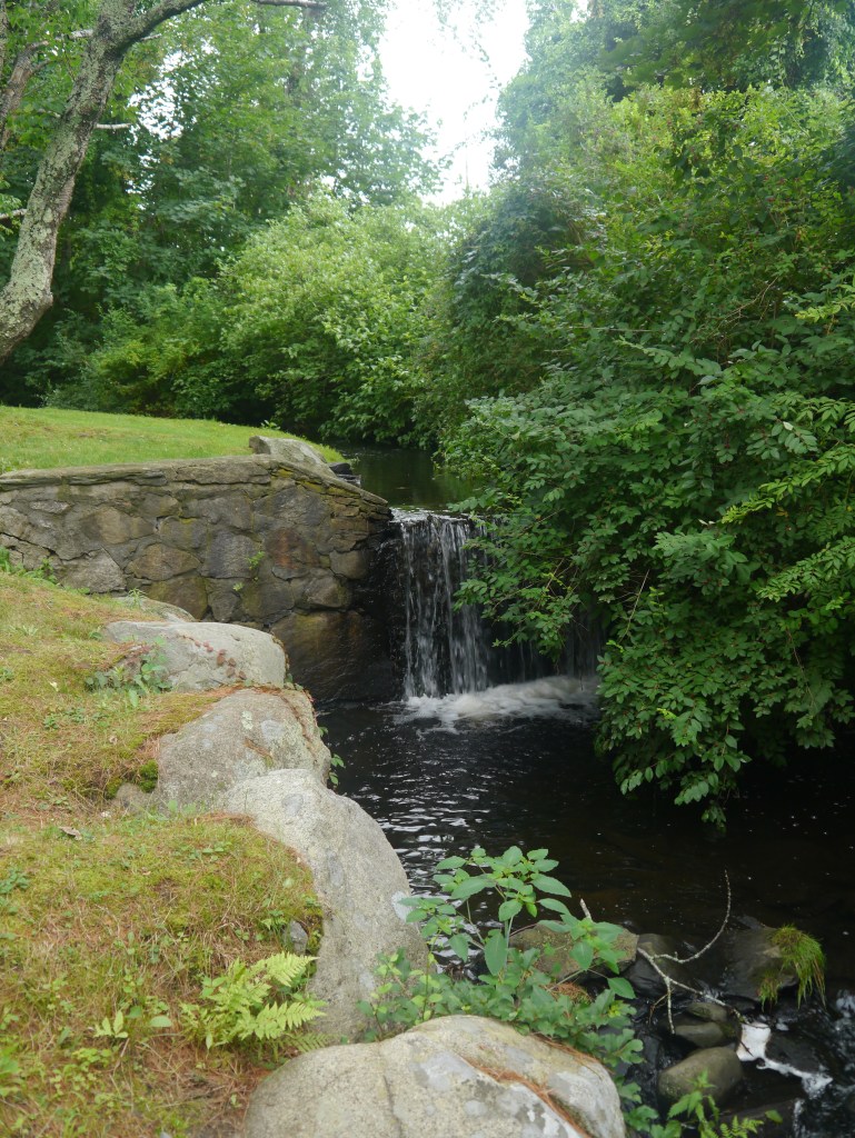
Mill Gatehouse: 96 Glen Farm Road. This house was on land purchased by Joseph Cundall in 1745. This house was probably built after that date. When the Cundall estate was later divided, this building was called the Gate House and probably served as the gatehouse to the Glen Mills. Cundall was a cloth worker who purchased a fulling mill on the banks of the Glen stream. This was a traditional site for a water powered mill and many mill structures were raised on the stone foundations. The mill you see today on the left side of Glen Farm Road is a more modern structure built to support Glen Farm a hundred years ago, but the foundations date back to colonial days.
Turn Oppose the Mill and turn around in the Glen Farm barn parking area. Backtrack north on Glen Farm Road and then turn left and take Glen Road back to East Main Road.
Proceeding South on East Main Road.
Southermost School 1725, a small, 1-story structure. In about 1800, it was moved from its original location on Union Street to the corner of Union Street and East Main Road and its stone chimney replaced by a brick chimney. In 1952, it was given to the Portsmouth Historical Society, moved to this site and restored in 1969-1970. It is one of the oldest one room schools in the United States.
In front of the Union Meetinghouse, at the corner of Union Street and East Main Road, -is a granite marker indicating the site of one of the first skirmishes between British and American forces in the Battle of Rhode Island on August 29, 1778.
Turn West on Union Street.
Almy/Hall House 559 Union Rear part built 1720. Front 1780. Lakeside, Lawton-Aimy-Hall, Farm c. 1690-1700, 1790-1800; A central entry in a 5-bay’ facade, in front, was added to a c. 169O-i700, 21/2-story, gambrel-roof structure at the rear. There are several wood-shingle 18th-century outbuildings and other 19th- and 20th-century structures on the 40-acre farm,which is surrounded and divided by dry-stone wails. The Lawton-Almy burying ground is on the property. The farm was in the Lawton and Almy families until 1938.
Head West on Union Street to West Main Road.
The Portsmouth Revolutionary Heritage Trail ends back at the Middletown border.
Sources:
Garman, James. Historic Houses of Portsmouth, Rhode Island, 1976.
Rhode Island Historical Preservation Commission. Historic and Architectural Resources of Portsmouth, Rhode Island: A Prelimary Report, 1979.
Vision Tax Appraisal Field Notes for Portsmouth RI.
Southermost School
Vintage Image of Prescott House (Overing House)
Around the Portsmouth Revolutionary Heritage Trail
Founder’s Brook is one of those touchstones where we come in contact with Portsmouth’s past. As I walked by the brook yesterday morning, I was aware that this site might have been lost to us without the effort of local people to preserve it.
In the early days of the town this site served as the “Watering Place.” It was a center of activity for the small community of settlers who stayed in Portsmouth in 1639 instead of moving south to the Newport area. A spring here provided drinking water, a location for washing (both animals and clothing) and a central location around which the house lots of the town were laid out. As the townspeople abandoned the idea of house lots in a village and migrated to homes on their larger farm lots, the area lost importance. The small lots here were absorbed into bigger farms.
It took the celebration of Rhode Island’s tricentennial in 1936 and Portsmouth’s tricentennial in 1938 to bring this location back into focus. Sometime after 1910 the Town of Portsmouth acquired the strip of land along the brook. The tricentennial organizers recognized the importance of the location and bought a chunk of land adjacent to the brook to serve as a central location to honor the town founders. Celebrations were held, a plaque honoring the Portsmouth Compact was placed on the puddingstone rock, and members of founding families added stepping stone rocks leading to the area. Founders’ Brook was saved as a treasured spot.
Founders’ Brook needed to be saved once again. In 1960 the state planned to construct a cloverleaf for Route 24 which would have obliterated Founders’ Brook. This time it was the Portsmouth Historical Society and the Route 138 business association that pressured the State Department of Public Works to make the changes to preserve the site.
With the celebration of Portsmouth’s 350th Anniversary, new efforts came to preserve and highlight the site. Memorial stones were added, new signage and a parking lot made it easier for visitors, and special events were held.
Preserving this beautiful site took vigilance, effort and passion. Hopefully we have the vigilance, effort and passion to preserve other historic landscapes in our town. Preserving Butts Hill Fort is another effort that will take vigilance and passion. We are richer as a community when we have these historic landscapes to remind us of our past.
The Sons of the American Revolution from Rhode Island and Massachusetts traveled by trolley and boat in August of 1902 to remember those who fought in the Battle of Rhode Island. The first order of business was a call to assembly and raising a large American Flag at the top of the hill. One speaker shared a letter written by Col. Sidney Coleman on the day after the battle. This letter was passed down in the family of St. Paul’s rector Rev. J. Sturgis Pearse.
Tiverton, Aug. 31, 1778
“The day before yesterday about 7 o’clock in the morning, we were alarmed that the enemy were advancing upon us, as the night before we had retreated from near the enemy’s line to the north end of the island. They began to fire upon our advance parties, who retreated, as was intended. As soon as they came in sight of our army they formed a line in order for a general attack, but seeing we were formed and our artillery playing warmly upon them they altered their disposition and a part of them moved as though they intended to attack our left flank. Our regiment was ordered out to check their approach, which I believe was only a feint to draw our attention, as very soon afterward they advanced upon our right and made three attempts to gain a small eminence on which was a redoubt, but were as often repulsed.
The fire continued from about 8 o’clock til 1 o’clock, a great deal of the time being pretty warm. Then again they moved to our left, when the other three regiments of our brigade were ordered to move forward in a line with us, and General Tyler’s brigade of militia upon our right. Whether they were tired of the business, which I believe to be the case or whether they disliked our disposition, I cannot tell; at all events they did not see cause to advance, but retired to the top of Quaker Hill, about one mile in front of outline. The cannonade continued until dark. Yesterday we made sundry attempts by small parties to draw them into action, but could not. Last night the general ordered the army to retreat across the river, which we did with the greatest regularity, and completed the crossing of the troops by 2 o’clock in the morning without the enemy discovering the least of our intentions. Tomorrow morning we march for Providence.”
At the end of festivities “Everyone then scattered about the fortifications and viewed the surrounding country from all sides.” They marveled at the engineering required in the building of the fort.
The celebration moved to Island Park and the feast of a clam bake.
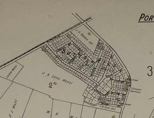
There would be no Butts Hill Fort to preserve and restore if the Reverend Roderick Terry hadn’t bought the site and the lands around it in the early 1920’s. Insurance maps were printed showing the 200-lothousing development and the Newport Mercury ads touted the site as “the most desirable place for a country home in the north end of the island.
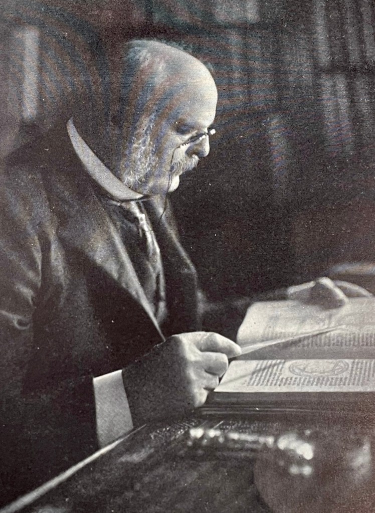
Rev. Roderick Terry
Who was Roderick Terry and how did he come to buy the Butts Hill Fort land? Terry was born in Brooklyn in 1849. His father was a wealthy businessman active in the railroad and telegraph industries. He graduated from Yale in 1870 and then he went on to study for the ministry earning a doctor of divinity from Princeton in 1881. He served as a minister in New York City for 24 years before retiring to Newport in 1905. Terry and his wife settled in a home owned by his wife’s family on Rhode Island Avenue. He had an active retirement. He volunteered his services (and his money) to organizations such as the Red Cross, Redwood Library and the Newport Historical Society. In 1918 Roderick Terry became the president of the Newport Historical Society and he was a dominant force in a renewal of that organization. His generosity rescued Butts Hill Fort, Fort Barton and the Sherman Windmill. Bu
Terry donated Butts Hill Fort to the Newport Historical Society, but he did so with strings attached.
1. The Newport Historical Society and its successors were to forever “preserve, keep and maintain” the property as a monument to those who fought in the Revolutionary War.
2. That the property will always keep the name “Butts Hill Fort.”
3. That the property should never be used for monetary gain.
Terry went on to stipulate that if the Newport Historical Society did not maintain the property, the State of Rhode Island had the right to step in and take it over. Terry turned over tracts of the Butts Hill land in 1923, but by 1968 the State of Rhode Island took over the land and placed it in the hands of the Town of Portsmouth. The town is still required to “preserve, keep and maintain” the property, to call it “Butts Hill Fort,” and to not use it for monetary gain.
The Butts Hill Fort Restoration Committee of the Portsmouth Historical Society is making an effort to follow through with Terry’s desires. Hopefully Portsmouth residents can see the value of restoring and maintaining our historic sites and landscapes. We may not have the resources that the Reverend Terry had, but we can contribute to the work and the funds to make Terry’s dream for Butts Hill Fort a reality – a place where families can come and remember the sacrifices others made for us to have a free country. It can be a place where families can enjoy walking the trails around the earthenwork fort and appreciate that in Portsmouth we still have history we can see.
Are you interested in applying your time and talents to the effort to preserve and restore Butts Hill Fort?
Volunteering/further info can be addressed to Seth Chiaro
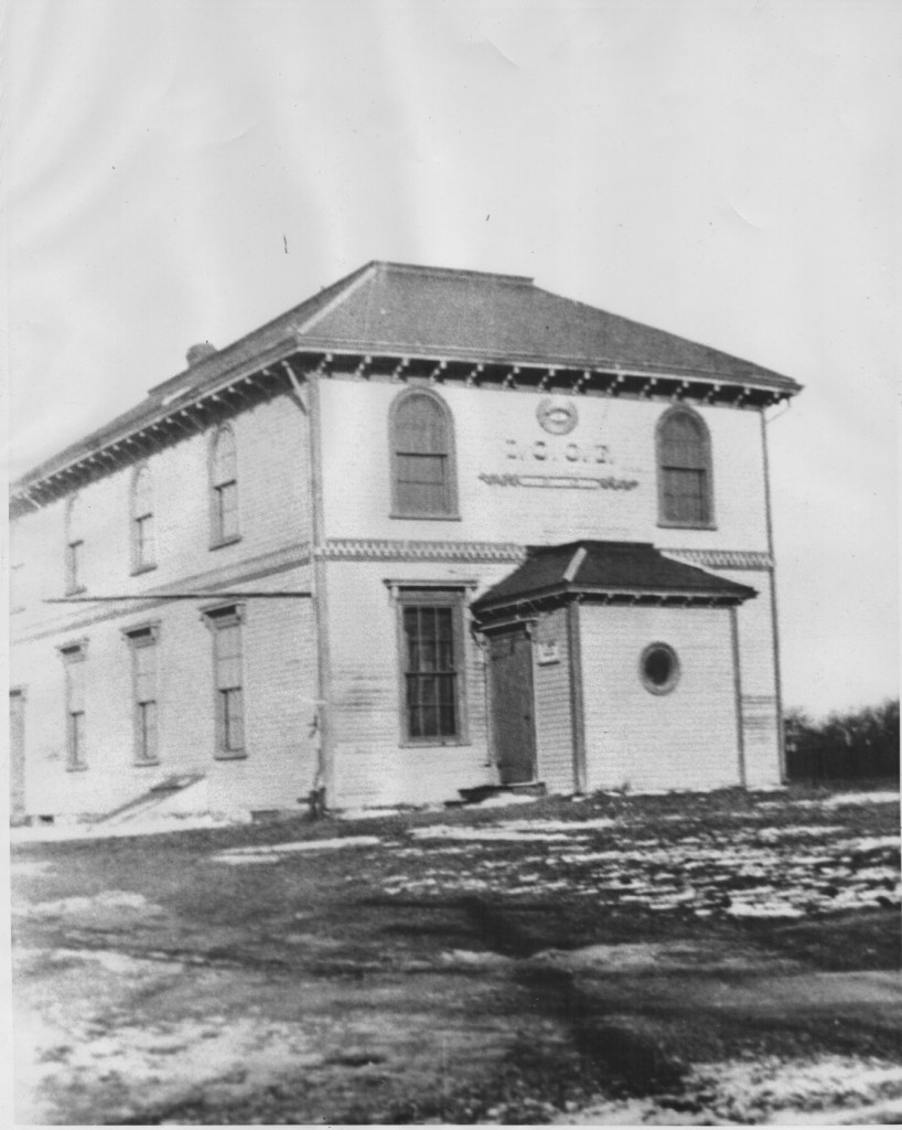
“A roaring fire last night destroyed the Oakland Odd Fellows Hall at 126 East Main Road, Portsmouth, after 250 people attending an auction walked quietly outdoors to safety.” (Newport Daily News – January 19, 1955).
Lost to Time? The Oakland Lodge was lost to time and Portsmouth in a rather dramatic way – a fire.
The fire that took the building in 1955 must have been a traumatic event. John E. Janes of Newport was the auctioneer and his assistant smelled smoke and discovered it on the second floor. Janes calmly led his patrons out of the building. He saved some of his merchandise, but lost 125 chairs in the blaze.
Fire equipment from Portsmouth, Middletown, Glen Farm and the Navy tried to put out the flames, but the water supply was limited. Fifteen thousand gallons of water had to be shuttled from a hydrant on the corner of Forest Ave and East Main Road. Empty petroleum trucks helped to ferry the water. Chief Henry W. Wilkey said that he could have had three 500 gallon pieces from Tiverton, but the Stone Bridge was not passable. Wilkey believed the fire probably started from an overheated stove pipe running through the partition.
In a recent blog I wrote about the arts in Portsmouth. In researching what was going on with the arts in Portsmouth in the 1920s, I came across a theater troop centered at Oakland Lodge. As I gathered materials for our 1920s exhibit at the Portsmouth Historical Society, I came across a photo of the Lodge. The Lodge was located close to the Middletown border on East Main Road. On the back of the photo (taken in April of 1925) there is a brief history of the Lodge.
“Oakland Lodge, No. 32, I.O.O.F., was chartered January, 1874, with twenty members, of whom Charles C. Slocum was Noble Grand; Samuel G. Arnold, Vice P.S., Constant C. Chace, W.S.; Peleg L. Thurston, P.S. and Herbert Chace, R.S. Oakland Lodge Hall was built in 1875. It was destroyed by fire on the night of January 18, 1955. The one story building that was built to replace it was used by the Lodge for about twenty years, until its membership grew so small, that it merged with the Excellent Lodge of Newport and the property was sold.”
The Independent Organization of Odd Fellows was a fraternal organization – one of the largest groups in the United States. Newspaper accounts show that the Oakland Lodge was a very active organization. The Odd Fellows were one of the first fraternal groups to welcome women – “Daughters of Rebekah.” Their purpose was:
To improve and elevate the character of mankind by promoting the principles of friendship, love, truth, faith, hope, charity and universal justice.
To help make the world a better place to live by aiding each other in times of need and by organizing charitable projects and activities that would benefit the less fortunate, the youth, the elderly, the environment and the community in every way possible.
To promote good will and harmony amongst peoples and nations through the principle of universal fraternity, holding the belief that all men and women regardless of race, nationality, religion, social status, gender, rank and station are brothers and sisters.
To promote a wholesome fraternal experience without violence, vices and discrimination of every form.
Although the Odd Fellows rebuilt and continued to meet for twenty more years, the members dwindled and they closed the doors in the 1970s.
On Memorial Day we think of those who have lost their lives in defense of our country. For us in Portsmouth, we have places that remind us of those who fought and died so that we might have a country. We do honor those of the Black Regiment at a special site near the entrance to Route 24. However, Portsmouth has a gem of Revolutionary War history that is being neglected: the But’s Hill Fort. Portsmouth residents are unaware of this remarkable place in our midst.
Butts Hill Fort is the largest remaining Revolutionary War fortification in southeastern New England.
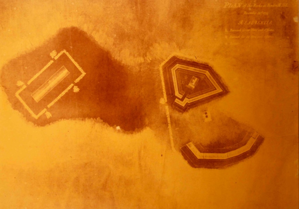
Butts Hill Fort Blueprint from Collection of the Portsmouth Historical Society
In 1776 Americans built a fort on what was known as Windmill Hill. After British troops invaded Aquidneck Island, British and Hessian troops occupied the earthworks fort that the Americans had started. Records show that in 1777 Portsmouth residents were pressed into service three days a week to construct a more substantial earthworks fortification and barracks for 200 men. In 1778 the French fleet was expected in Newport so the British abandoned the fort to reinforce lines around Newport. By August 11 the Americans once again occupied the fort at Butts Hill (Windmill Hill). When the Americans received the news that the French fleet had moved to Boston, the Americans tried to make a retreat from the island. The British came after them in what came to be known as the Battle of Rhode Island. The heights of Butts Hill Fort provided the American Commanders with a view of the battlefield – Butts Hill, Quaker Hill and Turkey Hill. Although the Americans occupied the fort for only 17 days, it was their command post during the battle. On August 31 the Americans retreated off the island to Fort Barton in Tiverton. When the British abandoned Aquidneck Island, the Americans once more controlled the fort in 1779. French forces would occupy the fort as well.
What happened to the fort after the Revolutionary War. Most earthen forts were destroyed by farming, but this area was much too rocky to be farmed. When the land around it was to be developed for housing lots, Dr. Roderick Terry of the Newport Historical Society was able to purchase the land. There were celebrations and the land was used as a park with historical markers. Dr. Terry deeded it to the Newport Historical Society, but with reservations.
Postcard Circa 1907
That the said Newport Historical Society and its successors and assigns shall forever preserve, keep and maintain the said premises as a memorial or monument to the memory of those who fought in the American-Revolutionary War and as a place where the public may enter, view and study the battle field on which our soldiers fought, be enlightened in the battles thereon fought, and in American history.
That said premises shall always retain the name of “Butts Hill Fort”.
That said premises shall never be used as a means of obtaining pecuniary gain or profit. Dr. Terry gave instructions:
I further provide that in the event that said Newport Historical Society shall at any time fail to preserve, keep and maintain the said premises as aforesaid or shall violate or fail to observe and carry out any of the foregoing conditions, then in that event the said Newport Historical Society shall forthwith stand seized of said premises to the use of the State of Rhode Island, in which State of Rhode Island the title to said premises shall forthwith vest; and I hereby grant and convey to said State the right to re-enter and take possession of said premises for any breach of the foregoing conditions by the said Newport Historical Society, said premises to be held, kept and, maintained by said State of Rhode Island for the uses and purposes aforesaid; and the Attorney General for the time being of said State or any other proper officer representing the said State shall have the right and authority to take possession thereof to the use of the State and may also be any appropriate remedy either at law or in equity, enforce the provisions of this deed. These provisions continue to control the property to this day!
By 1934 the Butts Hill Fort was overgrown and the State of Rhode Island took over the property. By 1968 the State transferred the property to the Town of Portsmouth for one dollar. Much of the land around it has been developed. Water towers, Portsmouth High School and the Wind Turbine all surround it. The earthworks are being eroded by vegetation. I’m not sure of the effect of the vibrations from the Wind Turbine The isolation of the spot seems to encourage vandalism. It is neglected, yet it is a site we should honor as we remember those who gave their lives for us to have a free country.
Resources:
National Register of Historic Places – Inventory Nomination Form for “Battle of Rhode Island Historic District.
“Planning, Preservation and Management Plan for Butts Hill Fort, Portsmouth, RI,” A Project of the Rhode Island Marine Archaeology Project, Funded by the National Park Service American Battlefield Protection Program, in Partnership with Newport Collaborative Architects (2009).
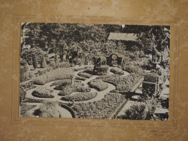
Vintage image of Green Animals from the collection of the Portsmouth Historical Society
Alice Brayton was born in Fall River in 1878, but she was a constant summer resident of Portsmouth. She made her permanent residence here in 1938. Her father, Thomas Brayton (treasurer of the Union Cotton Manufacturing Company), bought property on Cory’s Lane in Portsmouth in 1877 to be a summer home for his family. Alice’s father hired a Portuguese mill worker, Jose Carriero, to develop and manage the grounds of his Portsmouth estate in 1905. Carreiro was superintendent of the property from 1905 to 1945, and his son-in-law, George Mendonca continued as superintendent until 1985. They were responsible for creating the topiaries. There are more than 80 pieces of topiary throughout the gardens, including animals and birds, geometric figures and ornamental designs, sculpted from California privet, yew, and English boxwood.
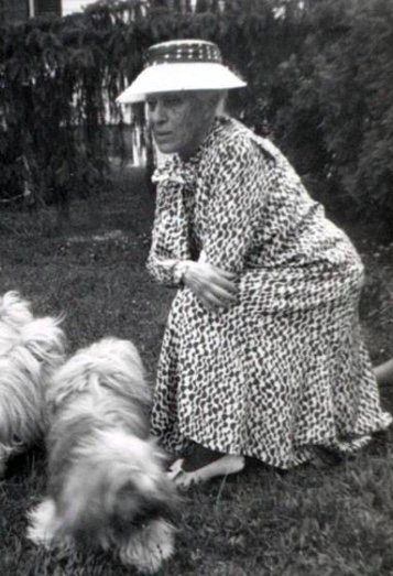
When Thomas Brayton died in 1939 at age 96, he left this estate to his son and daughter – Edward and Alice. Alice Brayton had re-opened the main house on the Portsmouth estate in 1936 to begin renovations to make it her permanent residence. She moved to the estate in the spring of 1939 naming it “Green Animals” for the topiary animals in the garden.
Alice Brayton was a woman of many interests. During the Depression she helped to found a relief program in Fall River to bring milk, food and clothing to the needy. She founded a nursing association in Fall River. In Portsmouth she was active with the Red Cross and even opened her home for “home nursing” lessons. She published many books and contributed to “Gardens of America” – a major work on historical gardens. She wrote a scholarly work on Bishop Berkeley who was a colonial resident of Middletown. She encouraged excavations around the Old Stone Mill in Newport and wrote a paper on this. She was a force in the early days of the Preservation Society of Newport Country. Miss Brayton left Green Animals to the Preservation Society of Newport County at her death in 1972. Newspaper accounts list her as a speaker for a number of local societies. She spoke to the Portsmouth Historical Society in 1966 about “More Recollections of a Portsmouth Native.” Obviously she considered herself a Portsmouth native.
Alice Brayton loved to garden and she loved to entertain She hosted Jacqueline Bouvier’s (Kennedy) debutante party. When President Eisenhower visited the area, she opened her gardens to the First Family and the White House press corps. Alice’s topiary gardens survived the hurricanes in 1938 and 1944, but the 1954 hurricane badly damaged a double row of spruces and a large hemlock. The famed topiaries were coated with salt spray. Although some experts thought many could not be saved, George Mendonca and his helpers rewired and trimmed the sculptures. Alice herself would putter around the gardens. She said she had a habit of mowing around the base of a topiary policemen “so that he wouldn’t hurt his feet standing all day on the grass.” Alice Brayton was known for her wit. One of her last public events was a $1,000 a plate dinner for the election of Nixon in 1968. Alice took a sip of sherry and headed home without dinner “because it was past her bedtime.”
During her lifetime, Alice enjoyed letting the public enjoy her gardens. Today “Green Animals” attracts thousands of visitors to Alice Brayton’s beautiful gardens.