As I try to imagine giving a tour of the Butts Hill Fort, I am coming across military terms that I need to understand. Thankfully, there are others in the Butts Hill Fort Restoration Committee that are willing to share their knowledge with me. I find that I have been using the term “fort” rather loosely.
Stephen Luce reminded me: “The fortifications there were called ‘works’ from 1775/6 to 1780. There was never a ‘Windmill Hill Fort’ because the Fort did not exist until the French combined the separate works in 1780/81 and by that time the hill was called Butts Hill.”
Going back to the revolutionary terminology guides (American Battlefield Trust Glossary) clarified things for me.
Fort: A fully enclosed earthwork; a fortified building, enclosure, or strategic position.
Fortification: Something that makes a defensive position stronger, like high mounds of earth to protect cannon or spiky breastworks to slow an enemy charge. Fortifications may be man-made structures or a part of the natural terrain. Man-made fortifications could be permanent (mortar or stone) or temporary (wood and soil). Natural fortifications could include waterways, forests, hills and mountains, swamps and marshes.
The British works at “Windmill Hill” were fortifications. When they arrived on the island they took over an American militia made natural (hill top) defensive position that was a temporary construction of wood and soil. The British sought to make it a more permanent fortification with the building of barracks and a guard house.

Note there is an “Abbatis” around the barracks. Abatis: A line of trees, chopped down and placed with their branches facing the enemy, used to strengthen fortifications.
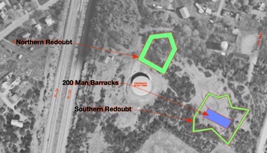
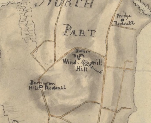
As we look at the military maps of the time, it is clear that the British fortification at Windmill Hill was not enclosed as a fort would be. It was a more permanent fortification because they had built structures such as a guard house and a barracks. It was carefully planned and as Frederick Mackenzie’s diary proves, it was worked on over time to improve the position. The Edward Fage map shows a second redoubt – the Southern Redoubt – was added to the fortifications. This was the condition of the fortifications when the Americans returned to Aquidneck Island in August of 1778.
Resources:
“Plan of a barrack for 300 men, and officers, erected at Windmill Hill with an abbatis, December 1777 : Plan nr 18..” https://quod.lib.umich.edu/w/wcl1ic/x-6053/wcl006127. University of Michigan Library Digital Collections. Accessed: December 19, 2021.
Planning, Preservation and Management Plan for Butts Hill Fort, Portsmouth, RI. A Project of the Rhode Island Marine Archaeology Project.
American Battlefield Trust website.
Fage, Edward, 1777-1779: Manuscript chart of Aquidneck Island and environs. Original in the Clinton Collection, Clements Library, University of Michigan at Ann Arbor. Plan of the adjacent coast to the northern part of Rhode Island, to express the route of a body of troops under the command of Lieut Colonel Campbell of the 22d: Regiment to destroy the enemies batteaux, vessels, galley &c &c &c which was accomplished May 25th 1778 / laid down and drawn by Edwd Fage, lieutt. of artillery.

Leave a comment