August 29, 1778
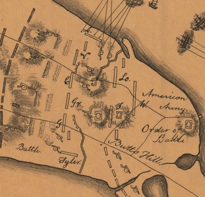
General Sullivans main aim at this stage of the RI campaign was to protect the retreat route to Howland Ferry. Sullivan was positioned at Butts Hill were he occupied fortifications left by the British that could accommodate his officers and staff. It commanded a view of Howland Ferry and Bristol Ferry to the north and East and West Roads to the south.
Beginning positions: Primary Line
Somewhat south of Butts Hill, Sullivan deployed his army of five to six thousand men along a fortified line almost two miles long which stretched across Aquidneck Island from the East Passage (Sakonnet River) on the east to Narragansett Bay on the west.
Gen. John Glover’s brigade (4 Massachusetts Regiments of Continentals), was stationed on the left, near East Road and facing Quaker Hill.
Glover’s left flank was protected by Gen. John Tyler’s Connecticut militia.
To Glover’s right, in the center, was a brigade temporarily under Col. Christopher Greene (who had been shifted from his usual command of the Black Regiment). Col. Greene commanded a state regiment from Massachusetts and a state regiment from New Hampshire and two Providence County militia Regiments. Butts Hill stood to their rear.
To Col. Greene’s right, the line was extended to West Road by Col. Ezekiel Cornell’s R.I. Brigade.
Across West Road from Cornell, facing Turkey Hill to the south, was Gen. James M. Varnum’s Brigade of four Continental regiments.
Flanked on the far right of Varnum was Col. Henry Brockholst Livingstone’s 1st Canadien regiment. They extended down a hill toward the Bay.
Holding a redoubt on the far right (Burrington’s) was Christopher Greene’s Black Regiment, under command of Maj. Samuel Ward, Jr.
Nathaniel Greene was in command of the entire right wing.
Advanced Guards:
Sullivan posted the light infantry unit of Col. John Laurens on West Road.
Col. Henry Beekman Livingstone was posted on East Road.
Secondary Line:
2000 Massachusetts Militiamen, (Titcomb’s Brigade to the east and Lovell’s Brigade to the west ) were situated to the north of Butts Hill.
Further to the north were the reserves, General William West’s 800 Rhode Island militiamen. They were newly drafted and the least experienced.

Resources:
Denison, J. Map of Newport, Rhode Island, and vicinity showing the disposition of American and British forces in August 1778 [map]. No Scale Provided. Retrieved June 15, 2022, from https://geodata.lib.utexas.edu/catalog/princeton-s7526f86c
McBurney, Christian. The Rhode Island Campaign. Westholme Publishing, Yardley, Pennsylvania, 2011.

Leave a comment