
What was Portsmouth like during the British Occupation? What happened during the Battle of Rhode Island? Who lived in Portsmouth during this time and what happened to their property? These are questions I have been asking as I do research for Butts Hill Fort and the Battle of Rhode Island. Recently I was able to get more answers through poring over an online map recently found by a member of the Butts Hill Fort Restoration Committee. It is part of the map collection of the Huntington Library, but there are some mysteries about it. Usually a map lists a “maker” – the person who drew the map. This map lists no maker, but it is clear that the maker was part of the British occupying forces. The Legend reads:
“Plan of the northern part of Rhode Island in the township of Portsmouth. Shewing the British posts of defence as compleated during the possession of Rhode Island, from the 8th of Dec. 1776 to the 25th of Oct. 1778. When the Siege of Newport was raised after the Attack of the French and Americans in August 1778. The Enemy retreated the 29th and remained two days in possession of Wind-Mill Hill. The Kings Troops pursuing them took the Position upon Quaker Hill as represented in the Plan, till the Enemy totally vacated the Island the 1st of September, 1778.”
The map itself is neatly done, but there are interesting notes here and there. This blog will feature some of the notes about Portsmouth citizens and what happened to them during the Occupation and battle.
“Peleg Headly was murdered by us and his house destroyed on the 29th of August.” was one note that struck me. There was a Peleg Hedly in Portsmouth at the time, but I have not found a death record for him.

This map shows the Bristol Ferry area. The notes provides the location of a Rebel made fortification. The Bristol Redoubt “was left by the Rebels about 1775, nearly finished.” A note to the north of the Bristol Redoubt tells us houses were destroyed and orchards were cut down between Town Pond and the Bristol Ferry landings. Another orchard was cut down off of Bristol Ferry Road to the south of the ferry landings. William Burden (Borden?), Codington (Coddington) and Earl are three of the farmers mentioned. Widow Westgate’s house was made into a barracks for 50 soldiers. Other farms mentioned are those belonging to George Irish, David Anthony, Stephen Brownell and George Hall.
The Wilcox (Cook Wilcox) “house burnt by some fire from the Lark Frigate when she blew up August 1778.”
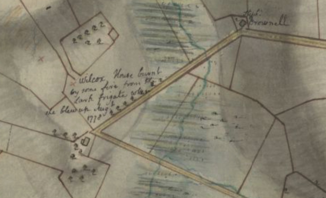
As the French fleet was arriving in late July of 1778, the British ordered that their ships would be destroyed rather than be taken by the enemy. The frigates Lark, Cerberus, Orpheus and the Juno were no match for the French ships coming in. The Lark’s Captain Smith ran his ship aground and set her on fire. The Lark’s 76 barrels of gunpowder exploded and ignited the Wilcox home. Flaming debris landed as far away as three miles. In his diary, British engineer Frederick Mackenzie wrote: “It was a most mortifying sight to us, who were Spectators of this conflagration, to see so many fine Frigates destroyed in so short a time, without any loss on the part of the Enemy.”
More notes from the map in future blogs.

Leave a comment