Frederick Mackenzie’s Diary and Edward Fage Maps give us an idea of the preparations the British made for an American attack in June of 1778.
Mackenzie diary, June 6, 1778: “A new Chain of Redoubts lately constructed for the defense of Newport, are now complete. The ground in all parts extremely advantageous; but I think some of the Redoubts are not well placed and that in general they are too confined. They are called, Green-end, Dudley’s, Bannister’s, Irishes, and Tomini….”
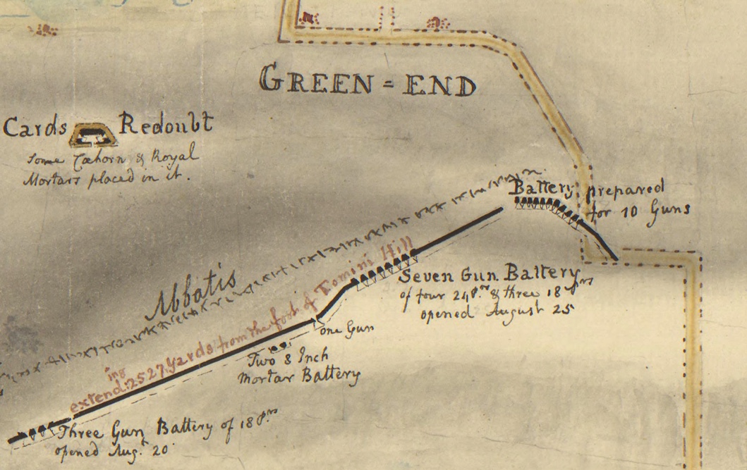
Mackenzie expresses concerns about the Green End Redoubt. It is “very small” and intended for 3 guns. He laments that a soldier in one of these redoubts could only “fire directly forward…” He muses that the engineer designed it to “show his fancy.” The Green End Redoubt was on the high ground above Green End Pond to complete the outer walls of defense. Two thousand British and Hessian soldiers as well as Loyalist volunteers would be stationed along the redoubt lines. While construction was going on General Pigot ordered all trees to be chopped down and all houses burned down so that the enemy could be detected.* Later in the diary entry Mackenzie suggests that another redoubt should be built to the right of this redoubt to have better control over Easton’s Pond.
Mackenzie states “Dudley’s Redoubt is certainly placed too far back. If it had been about 60 yards forward it would have answered every purpose much better.” Charles Dudley, the owner of the land on which the redoubt was built, had left in 1775. His home had become a hospital before the redoubt was built.
Mackenzie goes on to write: “Bannister’s and Irishes have a very good command of the adjacent ground.” He would have changed the position of Irishes Redoubt. The John Bannister family (Loyalists) had been at their Middletown country home. The British tore down the home next door that had belonged to George Irish who had left to join the Rebels. Marian Desrosiers in her book about the Banister family wrote:
“The redoubts the British built on both the Irish and Banister properties were about thirty to fifty yards on two sides and twenty yards in front of each redoubt to prevent American solders from storming the area.” (1).
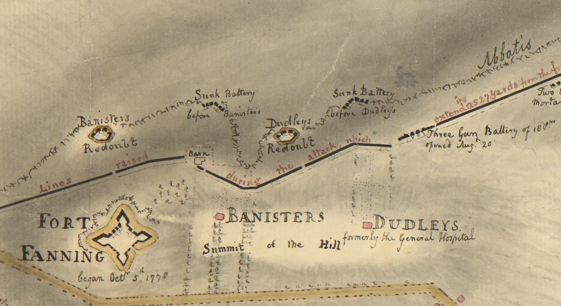
Thomas Banister had left Rhode Island to fight with loyalists and the British took over his estate, “West Farm”, that included the high ground at Miantonomi Hill. Mackenzie wrote: “Little Tomini should certainly have been formed as an outwork to the great hill. A single gun, en barrette, in a small work, open behind, would have been of service, as it would command a good deal of ground unseen from Great Tomini.” He saw Little Tomini as a liability.

References:
(1) Desrosiers, Marian Mathison. The Banisters of Rhode Island in the American Revolution. MacFarland, 2020.
Fage, Edward. Plan of the works which form the exterior line of defense for the Town of Newport. 1778. Clinton Collection, Clement Library.
Mackenzie, Frederick. Diary of Frederick Mackenzie, Vol. 1. Harvard Press,

Mar 08, 2022 @ 11:47:12
this is ALL such important work!
When are you back in town? – maybe we can schedule our first speaker about when you are back
>