It is hard for us to picture what Butts Hill Fort looked like when it ceased operation in 1781 (some say 1782). The French and Americans took the British fortifications, enclosed them and really make them into a real fort. I am searching for clues among the records of that time, maps, orderly books and those like Benson Lossing who record what they saw at the fort years after the abandonment of the fortification. I am trying to do this in an orderly way, putting together the clues of the primary sources. I have needed an education in military terms, so I have tried to put a definition next to words I had to research.
Today I am working with the Pictorial Field Book of the Revolution, Vol. 1. This was published in 1850 by Benson Lossing.
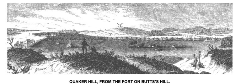
The remains of the old fort on Butts’s Hill, the embankments and fossé, with traces of the hastily-constructed ravelins, are well preserved. Even the ruts made by the carriage-wheels of the cannons, at the embrasures (for the ordnance was composed of field-pieces), were visible. The banks, in some places, are twenty feet high, measuring from the bottom of the fossé. Fortunately for the antiquary, the works were constructed chiefly upon a rocky ledge, and the plow can win no treasure there; the banks were earth, and afford no quarry for wall builders, and so the elements alone have lowered the ramparts and filled the ditches. Southward from this eminence, I had a fine view of Quaker and Turkey Hills – indeed, of the whole battle-ground.
What clues does this source give us?
Remains of hastily-constructed ravelins (Ravelins – Ravelin: a triangular fortification in front of bastion. (Bastions are generally curved or angular in shape. This allows the soldiers to keep a watch on the approaching enemy from many directions. as a detached outwork.
Ruts from carriage wheels of the cannons
Embrasures visible. (Embrasures – An opening for a gun to fire through)
Banks 20 feet high from bottom of fosse. (Fosse – ditch or moat)
On rocky ledge
Banks of earth,
Elements had lowered ramparts and filled ditches. (Rampart) main defensive wall of a fortification)
View of Quaker Hill and Turkey Hill from the south rampart.
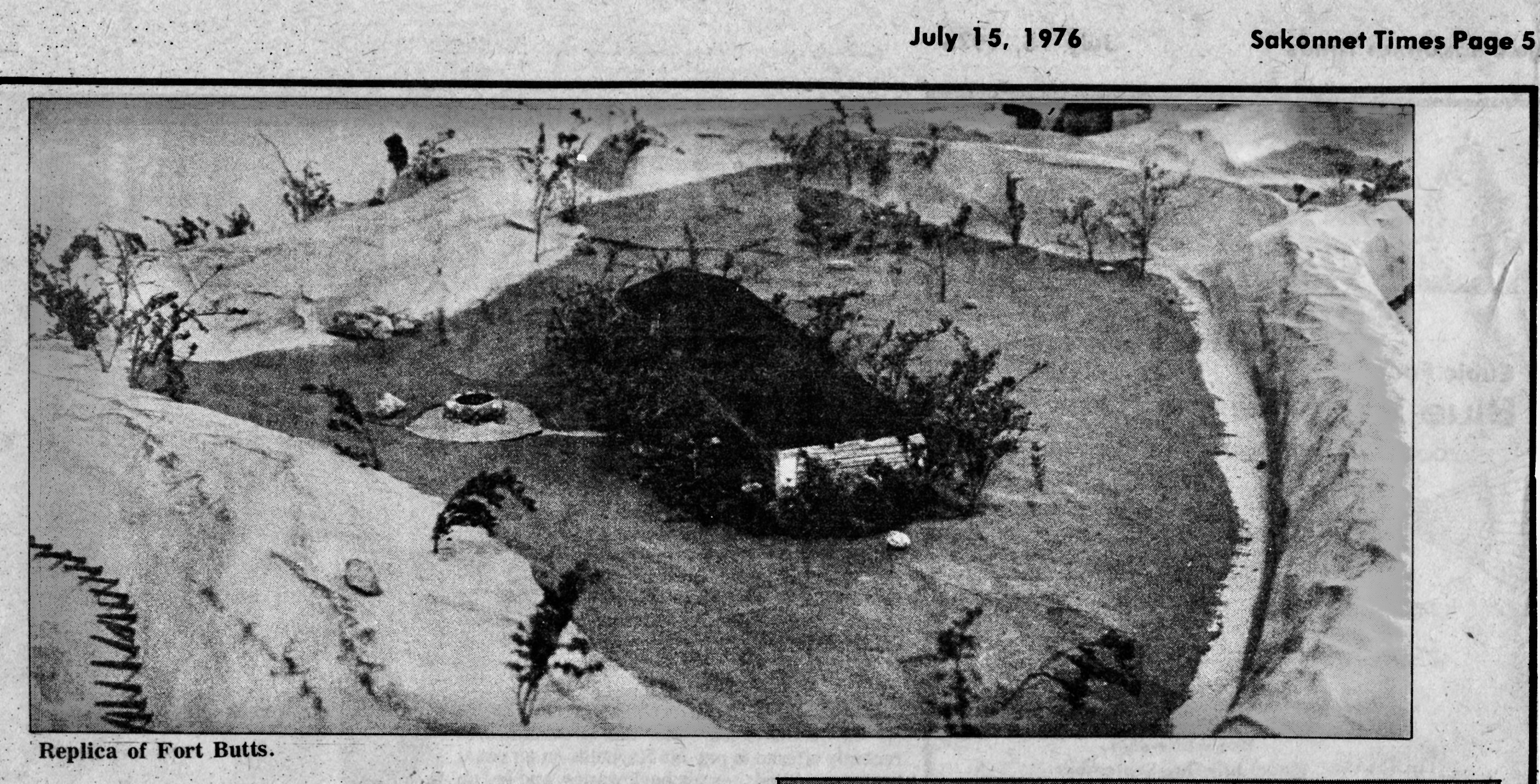
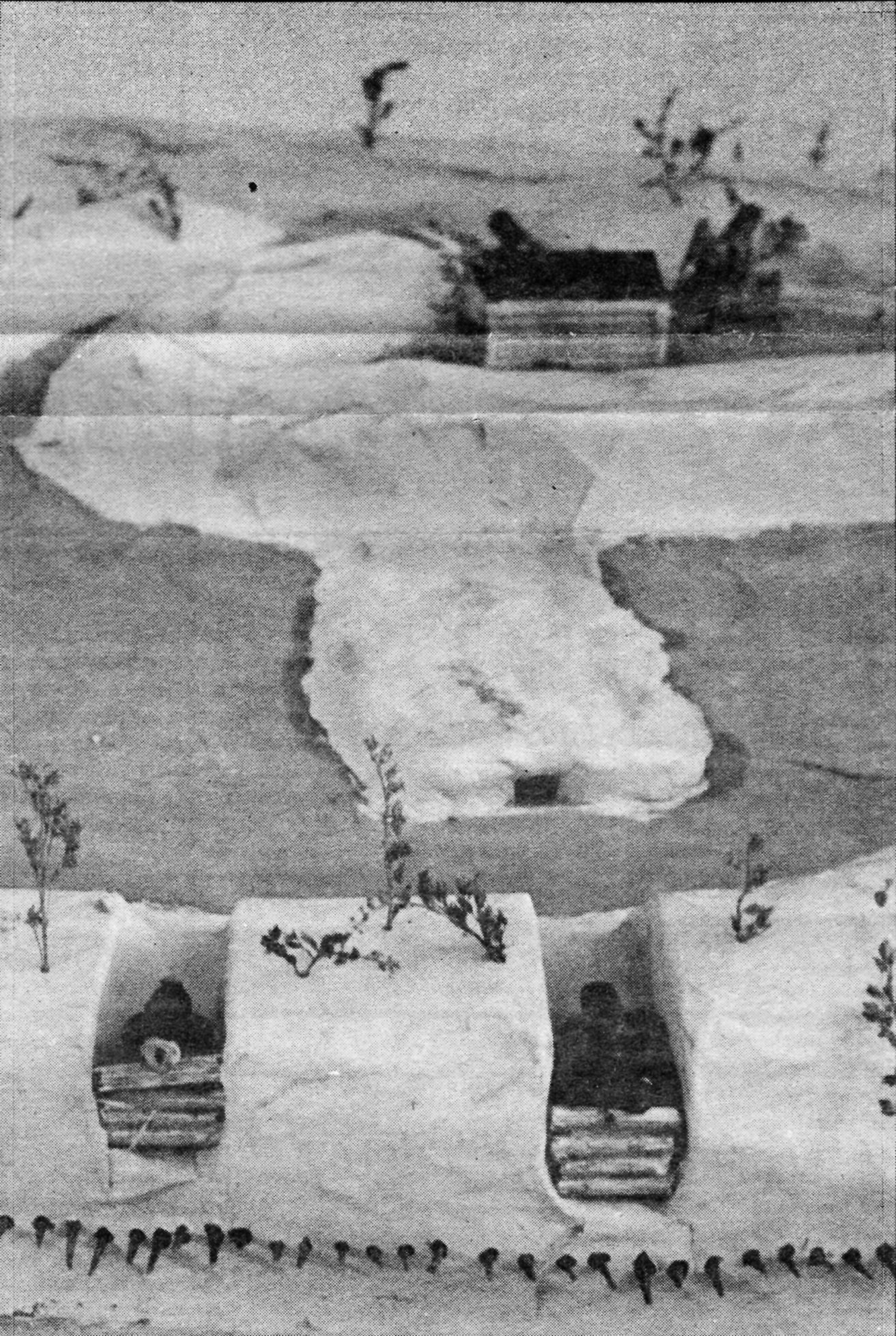
It is hard for us to imagine what Butts Hill Fort looked like. In the 1970s four Portsmouth High School Students tried to create a model of the fort. It was part of a project for an applied math class. One of the students was David Boscarino whose father was spearheading an effort to save the fort. The others were Robert Keshura, Ron Linhares and Brian Martineau. The model shows the abatis or tree branches arranged about the mote, the barracks and the cannon positions. Images of the model appeared in the July 15, 1976 issue of the Sakonnet Times.
Does anyone know what happened to the model?
My thanks goes to town historian Jim Garman for keeping such a great collection of Battle of Rhode Island material.
There has been so much growth in vegetation that it is difficult to imagine the view that General Sullivan would have had from his command post at Butts Hill Fort. Jim Garman has loaned me his notebooks from the 1978 re-enactments of the Battle of Rhode Island. His images clarify things.
Butts Hill FortView looking across Sakonnet to TivertonView from Butts Hill of Howland Ferry AreaView from Butts Hill overlooking Turkey Hill to the South
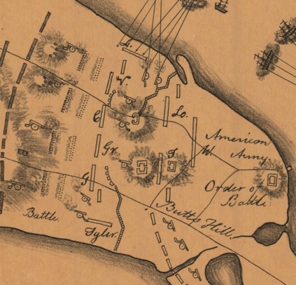
General Sullivans main aim at this stage of the RI campaign was to protect the retreat route to Howland Ferry. Sullivan was positioned at Butts Hill were he occupied fortifications left by the British that could accommodate his officers and staff. It commanded a view of Howland Ferry and Bristol Ferry to the north and East and West Roads to the south.
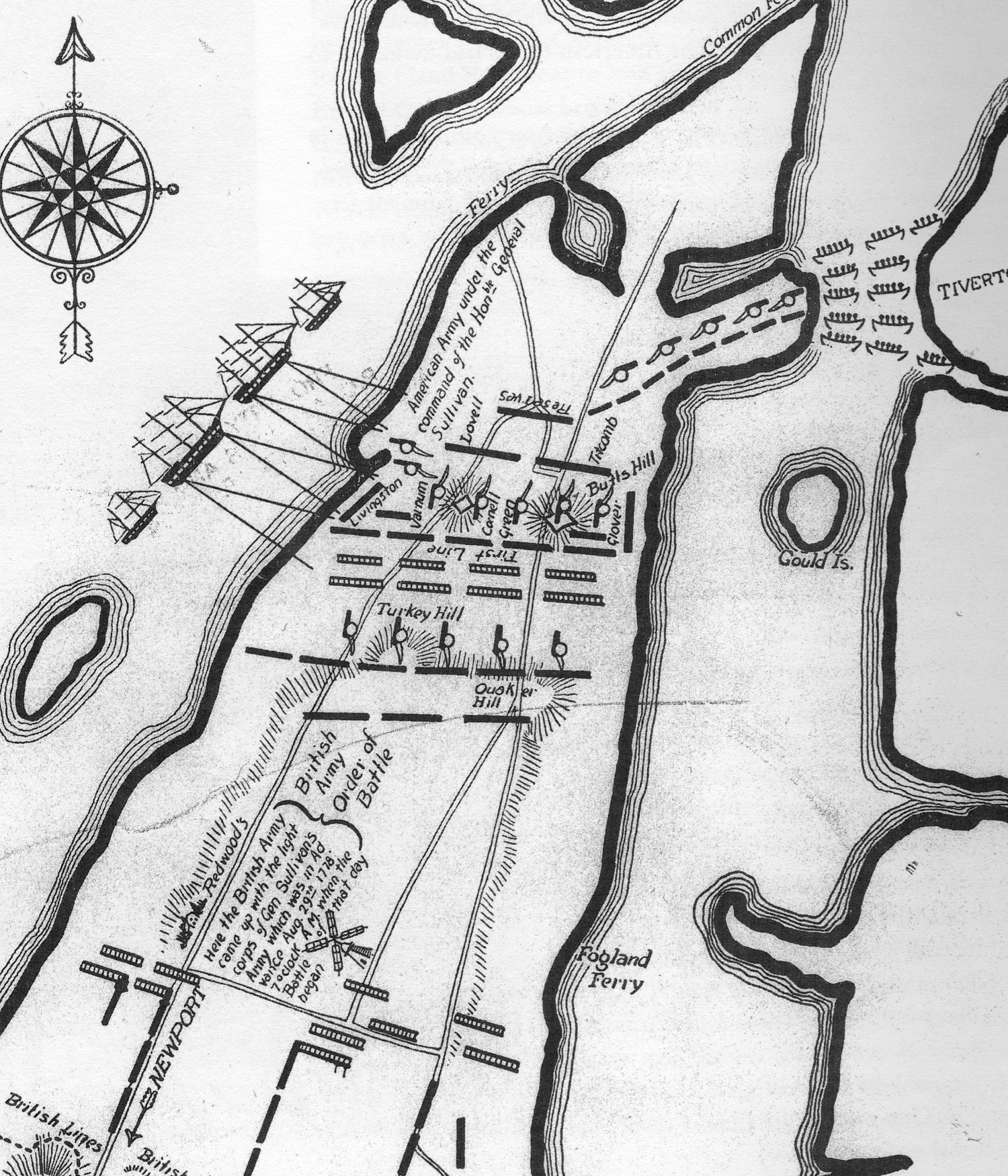
Beginning positions: Primary Line
Somewhat south of Butts Hill, Sullivan deployed his army of five to six thousand men along a fortified line almost two miles long which stretched across Aquidneck Island from the East Passage (Sakonnet River) on the east to Narragansett Bay on the west.
Gen. John Glover’s brigade (4 Massachusetts Regiments of Continentals), was stationed on the left, near East Road and facing Quaker Hill.
Glover’s left flank was protected by Gen. John Tyler’s Connecticut militia.
To Glover’s right, in the center, was a brigade temporarily under Col. Christopher Greene (who had been shifted from his usual command of the Black Regiment). Col. Greene commanded a state regiment from Massachusetts and a state regiment from New Hampshire and two Providence County militia Regiments. Butts Hill stood to their rear.
To Col. Greene’s right, the line was extended to West Road by Col. Ezekiel Cornell’s R.I. Brigade.
Across West Road from Cornell, facing Turkey Hill to the south, was Gen. James M. Varnum’s Brigade of four Continental regiments.
Flanked on the far right of Varnum was Col. Henry Brockholst Livingstone’s 1st Canadien regiment. They extended down a hill toward the Bay.
Holding a redoubt on the far right (Burrington’s) was Christopher Greene’s Black Regiment, under command of Maj. Samuel Ward, Jr.
Nathaniel Greene was in command of the entire right wing.
Advanced Guards:
Sullivan posted the light infantry unit of Col. John Laurens on West Road.
Col. Henry Beekman Livingstone was posted on East Road.
Secondary Line:
2000 Massachusetts Militiamen, (Titcomb’s Brigade to the east and Lovell’s Brigade to the west ) were situated to the north of Butts Hill.
Further to the north were the reserves, General William West’s 800 Rhode Island militiamen. They were newly drafted and the least experienced.
Resources:
Denison, J. Map of Newport, Rhode Island, and vicinity showing the disposition of American and British forces in August 1778 [map]. No Scale Provided. Retrieved June 15, 2022, from https://geodata.lib.utexas.edu/catalog/princeton-s7526f86c
McBurney, Christian. The Rhode Island Campaign. Westholme Publishing, Yardley, Pennsylvania, 2011.
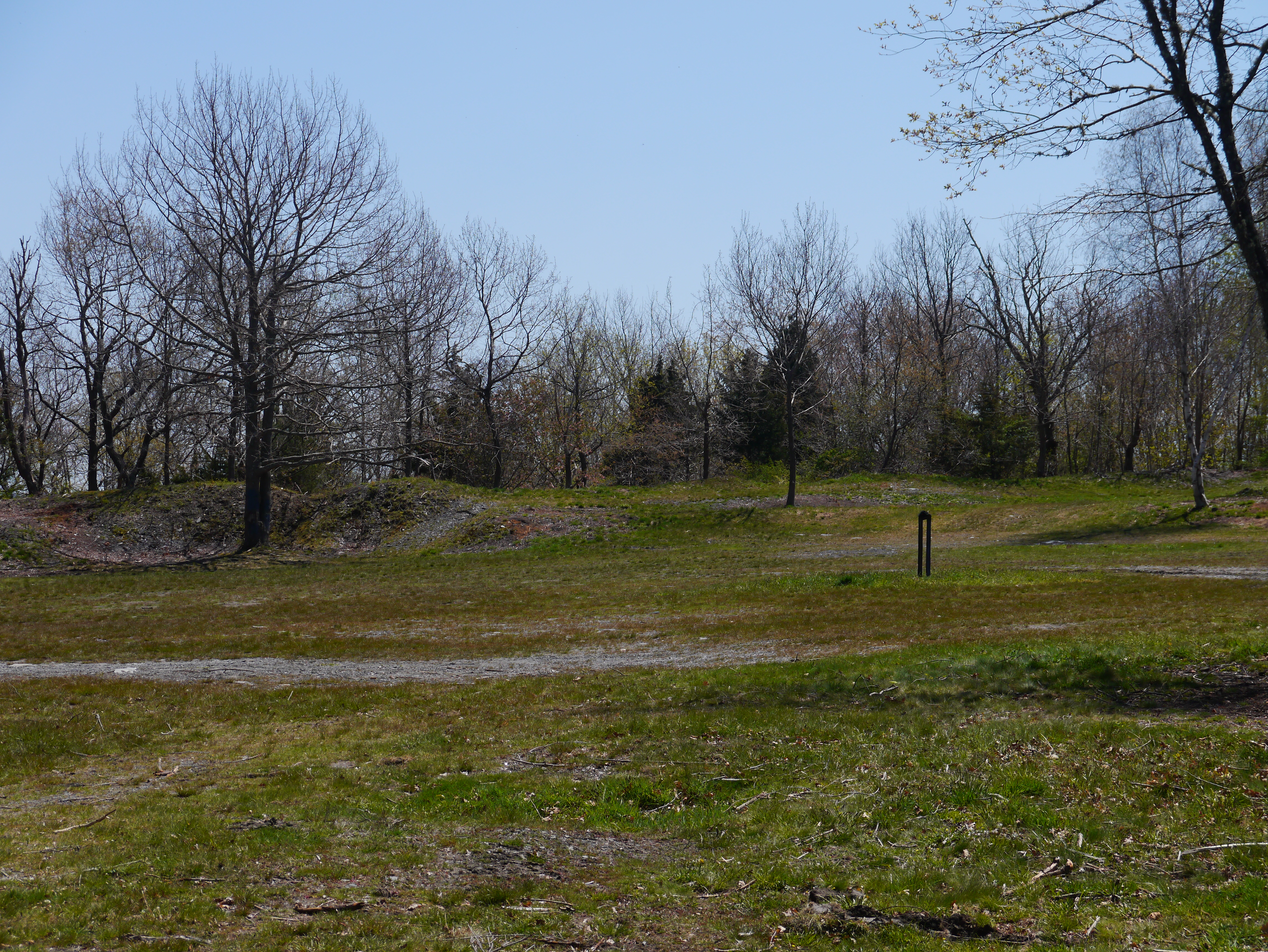
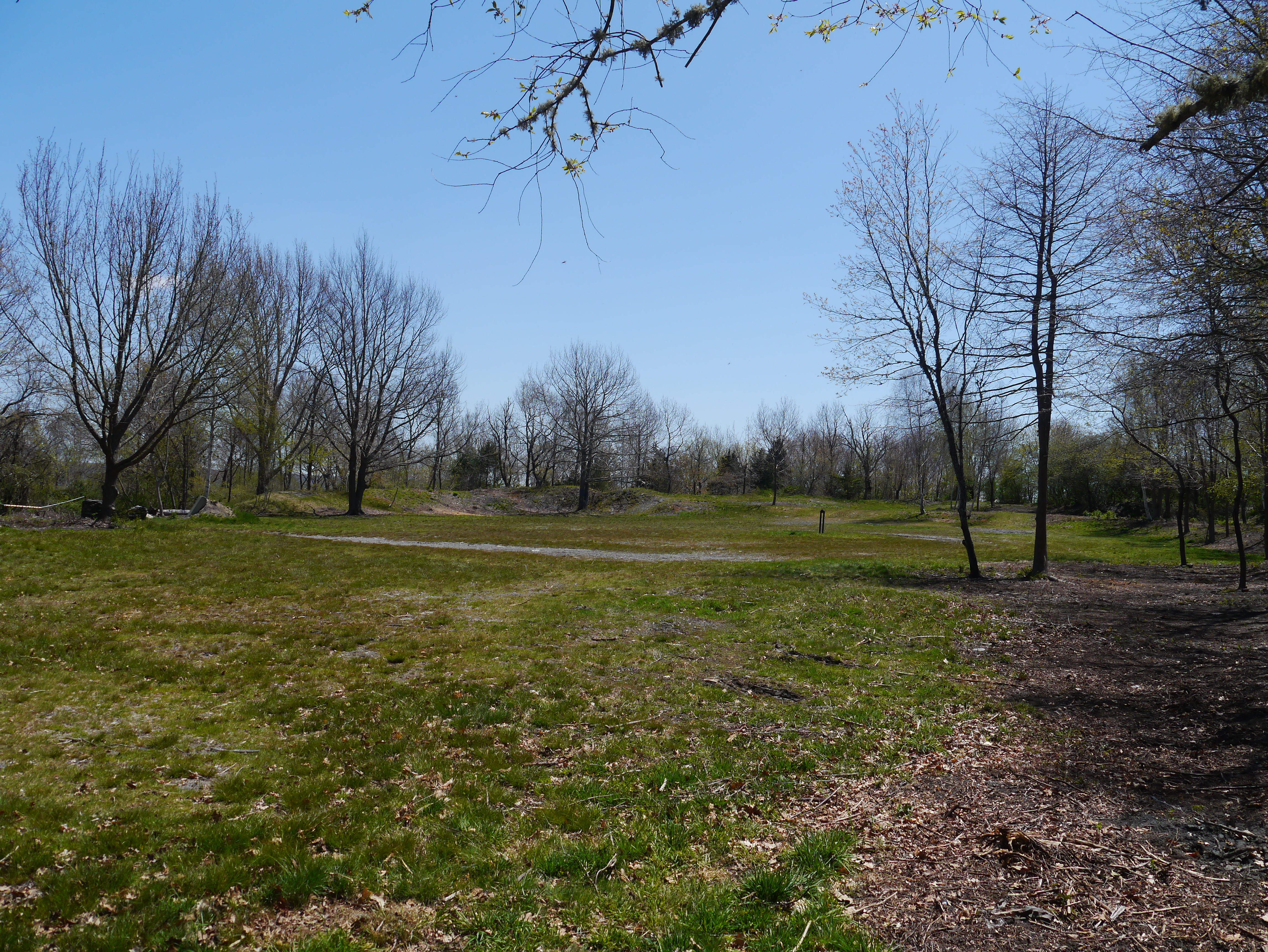
View from Parade 202020222020 stonewall by entranceCleared area around stone wall 2022West Ramparts 2022North Glacis and Moat 2022Parade Ground 2022View toward West Ramparts 2022
We welcome you to Butts Hill Fort. It may be difficult to understand what you can see today at the fort. The Butts Hill Fort Restoration Committee as part of the Battle of Rhode Island Association is working towards a time when there are marked trails, observation posts of three battle vistas, signage and QR codes to scan for more information. Meanwhile, we hope this tour helps to explain what you see at the fort.
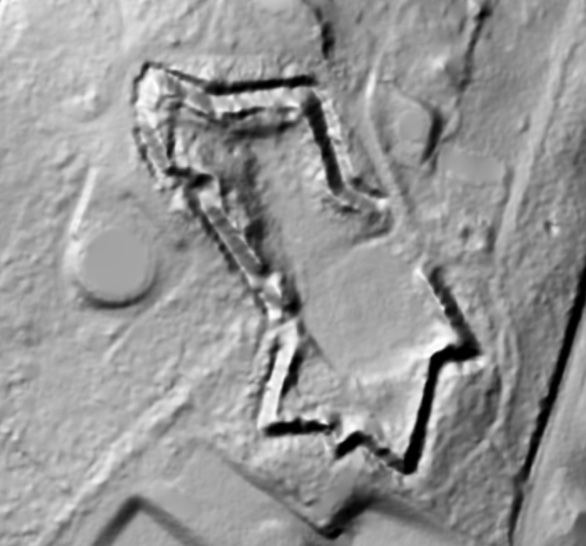
Butts Hill Fort (or Windmill Hill Fort) evolved along the way. The British called this area Windmill Hill because it was a traditional site for a windmill. The Americans called this area “Butts Hill” after the John Butts family that held the land when the war began. The outlines we are seeing date from the improvements made by the French (with the help of Americans) in 1780-1781. If you look at a LIDAR image of what the fort looks like under the vegetation, you would see the outlines clearly.
LIDAR ImageParts of fort we can see today.At first glance, What can we see?
We can see ramparts – large earthen mounds used to shield the inside of a fortified position from artillery fire and infantry assault. The ramparts protect a battery which is a cluster of cannons in action as a group.
North battery ramparts: The oldest portion of the fort. It is intact except for its south wall which opens to the parade ground.
South battery ramparts: The north, south and east faces of this battery’s ramparts are basically intact. The West ramparts were removed during the expansion of the fort when the French and Americans modified it (1780-1781).
Parade Ground: Place where soldiers practice or have parades.
At the Stop 2 at the North/East rampart and moat. Butts Hill in British Hands
Here we see the North ramparts with moat or ditch and glacis. At the base of the ramparts is the moat (depression surrounding a fortification). The moat was a natural result of early methods of fortification by earthworks, for the ditch produced by the removal of earth to form a rampart made a valuable part of the defense system with the glacis (an embankment sloping gradually up to a fortification, so as to expose attackers to defending gunfire) descending to the north.
If what we see today at Butts Hill Fort is the outline of the modifications made by the French and Americans, what was the fort like just before the Battle of Rhode Island?
We start the tour with the oldest section – the North ramparts. The Rebels had fortifications across in Bristol and they would often direct fire at the troops stationed by the Aquidneck Island side of the Bristol Ferry crossing. The British are beginning construction to enlarge the American fortifications.
Portsmouth residents are used as forced labor to construct fortifications for the British.
Sept. 17, 1777: “We are at present very busy in fortifying different posts on the Island; and there are already more works planned and traced out, than can possibly be finished by the end of December. …… A fortified Barrick on Windmill hill for 200 men.” (From Mackenzie diary).
Blueprints of the British fort plans and an overlay done by Dr. Abbass in her plans for Butts Hill Fort help us to visualize what the fort looked like just before the Battle of Rhode Island. Some of the fortifications were in what is now a residential area. We need to know other terms to understand the visuals.
Redoubt, (pronounced rih-dowt): An enclosed field work which had several sides and was used to protect a garrison from attacks from several directions. A redoubt could also extend from a permanent fortress.
Stop 3: South Ramparts: Role of Butts Hill in the Siege of Newport and Battle of Rhode Island: Butts Hill in American hands.
We are at the southern fortifications. This part of the story takes us to the three weeks in August of 1778 when the Americans held this high position during the Siege of Newport and Battle of Rhode Island.
South ramparts
Drone images from Butts Hill illustrate what a commanding view was possible from this location. The British were concerned with the view of possible American invasions from the north from Bristol and the east from Tiverton. For the Americans, however, the view south was essential.
July 29th: d’Estaing met with American Commanders when he arrived at Point Judith.
August 9th: Fearing an attack, British forces abandoned Butts Hill and General Pigot withdrew his forces to Newport as the French were landing on Conanicut (Jamestown). Sullivan discovered that the British had abandoned Butts Hill, so he and his troops crossed over to Aquidneck and occupied the high fortifications. He called for the heavy cannon at Fox Point to be moved to Portsmouth.
August 12-13: A hurricane hit that destroyed men, horses, camps and supplies on both the British and American sides. The storm caused the French Navy to abandon attack in Newport.
August 16: As the Americans built earthworks and dug trenches toward Newport, American reserves and the sick who were healthy enough to do garrison work remained at Butts Hill which served as Sullivan’s headquarters.
August 26: Americans now know that the British fleet is coming and that it would be at least three weeks before French would arrive. They begin to send their heavy cannon back to northern locations like Butts Hill. General Sullivan began to prepare for a retreat. This was not a hasty retreat.
August 28th: (From Sullivan’s letter to Congress after the battle): Sullivan details the positions of his forces on the evening of August 28, 1778.
“On the evening of the 28th we moved with our stores and baggage, which had not been previously sent forward, and about two in the morning encamped on Butts’s Hill, with our right extending to the west road, and left to the east road; the flanking and covering parties ____further towards the west road on the right and left.”
August 29th, 1778: What was going on around Portsmouth during the day of the battle?
West Main Road and Union Street Engagement:
During the early hours on August 29th around 7:00 AM, Hessian Chasseurs [rapid movement soldiers] made contact with American forces near the intersection of West Main Rd and Union Street. A small engagement took place from that area and would eventually lead towards the Lawton Valley. The Hessians would eventually break the American line with Artillery.
East Main Road and Union Street Engagement:
By 8:00 AM the British 54th, 22nd, 43rd, and the 38th Regiments of Foot are ambushed by Col. Nathaniel Wade’s American picket line. The 43rd took pursuit down Middle Road while the 54th, 38th, and 43rd continued down East Main Road.
Turkey Hill Engagement
German Captain Von Malburg pursued Col. Laurens Regiment to Turkey Hill. Laurens men took up a strong; defensive position on top of Turkey Hill. Col. Laurens’ Regiments fell back to General Nathanael Green’s position to the right of Butts Hill. By 8:30 AM the Hessians had secured Turkey Hill.
Quaker Hill Engagement:
The British units were now engaged on Quaker Hill. The British forces formed a line that extended from East Main Road to about where Sea Meadow Drive is now located. Americans were also formed between the Quaker Meeting House; and Hedly Street. Sullivan ordered the units fighting on Quaker Hill to retreat back to the mainline around Butts Hill Fort. The engagement on Quaker Hill lasted a full hour. The British attempted to attack Butts Hill Fort but the 18-pound cannons from the Fort kept the British from advancing.
Lehigh Hill Engagement (Durfee’s Hill)
General Nathanael Greene held the right flank of the American Army and along the right-wing stood a small artillery redoubt. This was a vital position for both sides. The 1st RI Regiment (The Black Regiment) was under the direct command of Major Samuel Ward who was commanded by Col. Christopher Greene. The Hessians tried multiple times to take the position. On the third attempt, the 2nd RI Regiment supported the 1st RI Regiment. As the 2nd RI Reg. approached the redoubt the Hessians were attempting to climb the walls. The Hessians retreated to Turkey Hill. Both sides exchanged cannon fire throughout the night.
The retreat plan in Sullivan’s words: “The heavy baggage and stores were falling back and crossing through the day; at dark, the tents were struck, the light baggage and troops passed dawn, and before twelve o’clock the main army had crossed with the stores and baggage.”
Stop 4: At the parade grounds
Parade Grounds
In December of 1779 the British finally departed from Aquidneck Island. The Americans regained possession of Butts Hill. The French arrived on Aquidneck Island on July 11, 1780 and the island was again occupied by troops. In October of 1780 one American militiaman would report in a letter:
“…there are about 7500 Men on the Island at the Several ports, 5000 of which are French, at Newport, 2000 Three Months Men, at this place and 500 Continentals, under Col. Greene of this state.”
The allied French and American forces felt secure, but they continued to prepare to defend the island. On Butts Hill there were American troops assigned to support the work of the French troops in restoring the fortifications. Through the summer and fall of 1780, Butts Hill was actively being enclosed and made into a fort by the Americans and their French allies. This is the fort shape we recognize today
Fort building was hard work. One entry records that the American wagons are bringing loads of stone to the works at Butts Hill Fort. They are building a “sally port” which is a secure, controlled entry way to an enclosure like a fort. All tools must be returned to the engineer. Members of the Black Regiment continued the “works” at Butts Hill Fort once the Massachusetts militias departed.
When Did Butts Hill become a Fort?
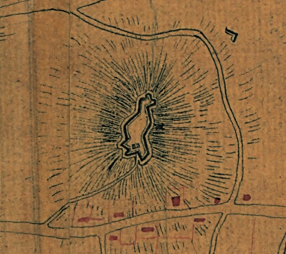
Rochambeau map shows outline of completed fort.
“The fortifications there were called ‘works’ from 1775/6 to 1780. There was never a ‘Windmill Hill Fort’ because the Fort did not exist until the French combined the separate works in 1780/81 and by that time the hill was called Butts Hill.”
Going back to the revolutionary terminology guides (American Battlefield Trust Glossary) clarified things for me.
Fort: fully enclosed earthwork; a fortified building, enclosure, or strategic position.
The British works at “Windmill Hill” were fortifications. When they arrived on the island they took over an American militia made natural (hill top) defensive position that was a temporary construction of wood and soil.
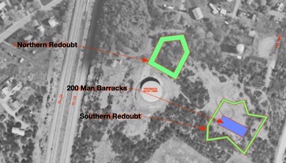
Fage Map 1778
The Edward Fage map (1778) shows a second redoubt – the Southern Redoubt – was added to the fortifications. This was the condition of the fortifications when the Americans returned to Aquidneck Island in August of 1778.
We think of the Black Regiment’s valor during the Battle of Rhode Island, but I am discovering more ties between the First Rhode Island Regiment (commanded by Col. Christopher Greene) and the construction of the fort at Butts Hill. According to pension petitions, they helped the French soldiers and masons complete the job of re-enforcing the fortifications at Butts Hill. Fifty of their soldiers were detached to help the French move their artillery. After two calls back to Aquidneck Island, they would later join the American Army on the march south and participated in the final battle at Yorktown.
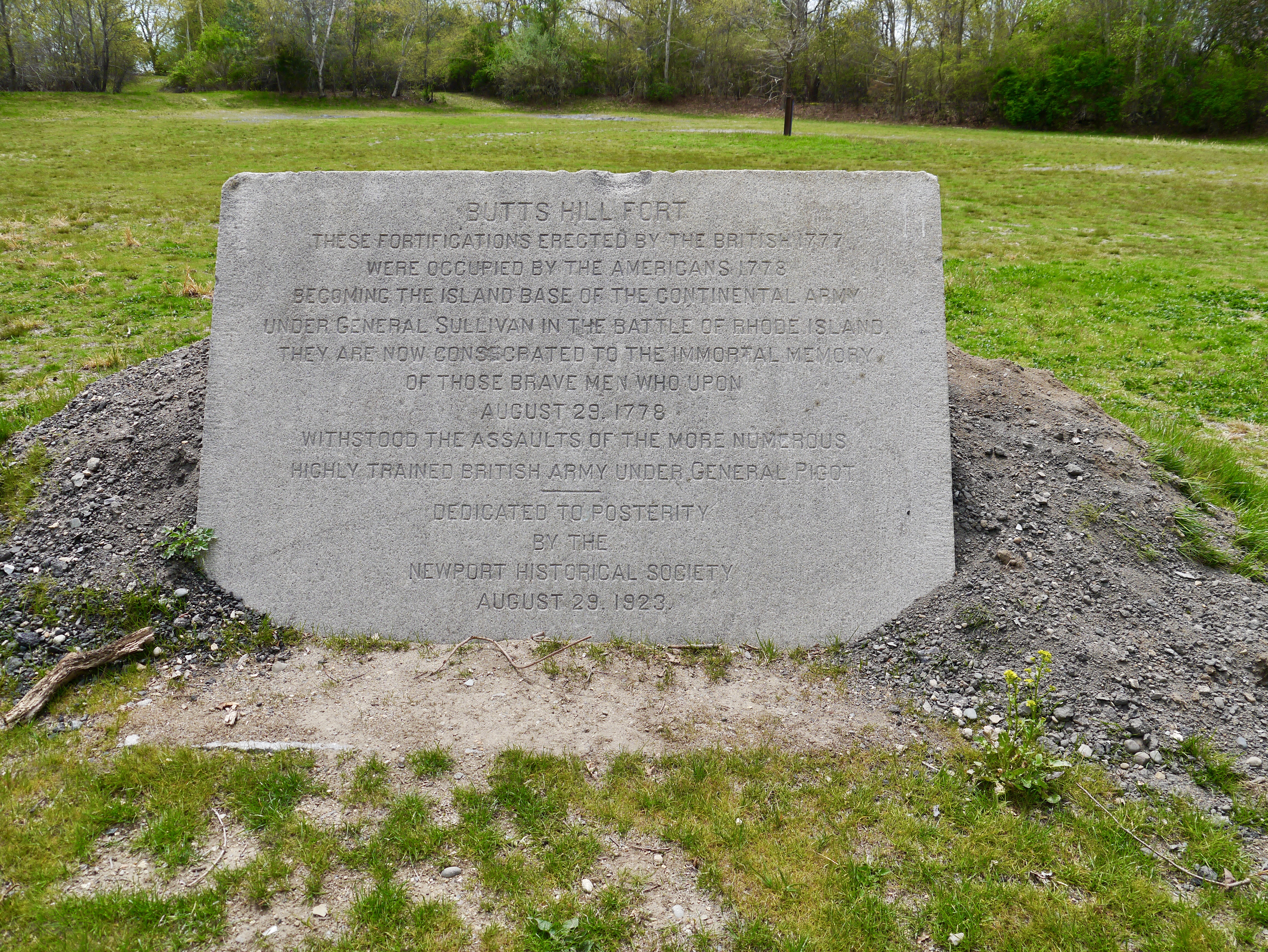
Stop 5: At the memorial
“Butts Hill Fort. These fortifications erected by the British 1777 were occupied by the Americans 1778 becoming the island base of the Continental Army under General Sullivan in the Battle of Rhode Island. They are consecrated to the immortal memory of those brave men who upon August 29, 1778 withstood the assaults of the more numerous highly trained British Army under General Pigot. Dedicated to posterity by the Newport Historical Society, August 29, 1923.”
1923 Memorial Stone
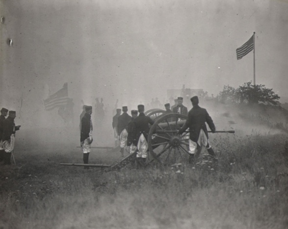
This memorial stone was dedicated with some fanfare. There were speeches and battle reenactments, marching bands and the blast of cannons. This sacred piece of land was saved from being a housing development by the then President of the Newport Historical Society, Rev. Roderick Terry. He personally bought the property (and Fort Barton as well) and gave them to the Society. This gift came with some restrictions:
*The Newport Historical Society and its successors were to forever “preserve, keep and maintain” the property as a monument to those who fought in the Revolutionary War. *That the property will always keep the name “Butts Hill Fort.” *That the property should never be used for monetary gain.
The Newport Historical Society could not maintain the fort. In 1968 the land was transferred to the State and on to the Town of Portsmouth. Terry’s restrictions on the property remain today as the responsibility of the town of Portsmouth.
The Butts Hill Fort Restoration Committee aims to fulfill Rev. Terry’s mandate to preserve, keep and maintain the property as a monument to those who fought in the Revolutionary War. The Committee is working on a land management plan to restore the fort and create an open space area of walking trails and informational signage. The three acres of land with the fort provide ample space for major re-enactments.
As the anniversaries of the American Revolution (2026) and Battle of Rhode Island (2028) draw near, the task of “preserving” the fort and ensuring that it is a monument to those who fought in the Revolutionary War becomes even more vital.
Butts Hill Fort These fortifications erected by the British 1777 were occupied by the Americans 1778 becoming the island base of the Continental Army under General Sullivan in the Battle of Rhode Island. They are consecrated to the immortal memory of those brave men who upon August 29, 1778 withstood the assaults of the more numerous highly trained British Army under General Pigot. Dedicated to posterity by the Newport Historical Society, August 29, 1923.
This memorial stone was dedicated with some fanfare. There were speeches and battle reenactments, marching bands and the blast of cannons. This sacred piece of land was saved from being a housing development by the then President of the Newport Historical Society, Rev. Roderick Terry. He personally bought the property (and Fort Barton as well) and gave them to the Society. This gift came with some restrictions:
*The Newport Historical Society and its successors were to forever “preserve, keep and maintain” the property as a monument to those who fought in the Revolutionary War. *That the property will always keep the name “Butts Hill Fort.” *That the property should never be used for monetary gain.
Dedication 1923
The Newport Historical Society could not maintain the fort. In 1968 the land was transferred to the State and on to the Town of Portsmouth. Terry’s restrictions on the property remain today as the responsibility of the town of Portsmouth.
The Butts Hill Fort Restoration Committee aims to fulfill Rev. Terry’s mandate to preserve, keep and maintain the property as a monument to those who fought in the Revolutionary War. The Committee is working on a land management plan to restore the fort and create an area of walking trails and informational signage.
As the anniversaries of the American Revolution and Battle of Rhode Island draw near, the task of “preserving” the fort and ensuring that it is a monument to those who fought in the Revolutionary War becomes even more vital.
A continuation of a tour of Butts Hill Fort : Stop 5: At the parade grounds
In December of 1779 the British finally departed from Aquidneck Island. The Americans regained possession of Butts Hill. The French arrived on Aquidneck Island on July 11, 1780 and the island was again occupied by troops. In October of 1780 one American militiaman would report in a letter:
“…there are about 7500 Men on the Island at the Several ports, 5000 of which are French, at Newport, 2000 Three Months Men, at this place and 500 Continentals, under Col. Greene of this state.”
The allied French and American forces felt secure, but they continued to prepare to defend the island. On Butts Hill there were American troops assigned to support the work of the French troops in restoring the fortifications. Through the summer and fall of 1780, Butts Hill was actively being enclosed and made into a fort by the Americans and their French allies. This is the fort shape we recognize today.
Rochambeau Map 1780
We get a glimpse of their work through the Orderly Books of Ebenezer Thayer and John Jacobs. An orderly book is a record of the day to day activities of a unit. Thayer recorded the activities of a troop assigned to support the Expedition Pariculiere, the French Expeditionary Army under the command of Rochambeau. Their service was from August 16th to November 28, 1780. Other orderly books and some letters written from the camp give us an idea of life in the camp. That life was not easy.
The September 9th entry by Thayer shows they were assigned six men to a tent with a cook for each group of six. Later entries show that the kitchens had to be moved higher to prevent the smoke from filling the tents. A later entry tells us that the guard consisted of sixty rank and file soldiers. There were also sentinels around the encampment – 2 in front and one in the rear. This is kept up day and night. This day’s entry also includes concern about the filth around the camp that could be detrimental to the soldiers’ health.
They were not equipped well. An entry expresses concerns that there were not enough axes. One of the “fatigue duties” (labor duties that don’t require arms) was gathering wood. The axes would have been essential to chopping wood. Wood on Aquidneck Island was so scarce they had to go to Freetown, Massachusetts to obtain firewood.
Soldiers were hungry and stole from nearby homes and they were disciplines for that. The officers had a hard time securing enough food to last a day so that they might be fit for duty. In a October 10, 1780 letter to friends in Boston, Major May of the Boston Regiment shares his experience.
“We have but 21 days to tarry here, but famine seems to stare us in the face. I could give you particulars, but I never was fond of telling all. It may suffice to say, that we have one day’s rations of Indian meal on hand, no meat, no wood, no sauce etc. Before I go any further I must tell you I have been, even now, sick with a stupefying cold. ..I hope I may be returned to you all again, in health and safety.”
One group that were assured of good provisions were those actively helping the French masons. “There are four men to be detached from the brigade to attend constantly on the French Masons until the stone pillows (pillars?) of the Fort are completed and two masons detached to assist the French Masons until the works are finished and for their service they shall receive half a pint of rum a day when in the store.” Their provisions are ready for them so that they can complete the Fort works in a timely manner.
Fort building was hard work. One entry records that the American wagons are bringing loads of stone to the works at Butts Hill Fort. They are building a “sally port” which is a secure, controlled entry way to an enclosure like a fort. All tools must be returned to the engineer. Members of the Black Regiment continued the “works” at Butts Hill Fort once the Massachusetts militias departed.
We think of the Black Regiment’s valor during the Battle of Rhode Island, but I am discovering more ties between the First Rhode Island Regiment (commanded by Col. Christopher Greene) and the construction of the fort at Butts Hill. This was a time of transition for the soldiers of the Black Regiment and it is not always easy to follow them as they were absorbed into other units and divided for assignments.
First, I need to provide some background. When the British voluntarily left Aquidneck Island in October of 1779, the Americans came back to find the Island decimated. The First Rhode Island Regiment joined the Second Rhode Island Regiment in Newport on November 3, 1779. After the British Occupation, supplies of food and wood were dangerously low in Newport. They were sent to winter in Providence and East Greenwich. In early February of 1780 one report had the regiment at about 143 privates. They had orders to march for New York, but the arrival of the French on Aquidneck Island changed the plans.
On July 10, 1780 the French fleet and army arrived in Newport. General Heath of the American Army acted as Washington’s liaison, but on July 25th he was joined by Major General Lafayette. Five thousand French soldiers set up camp in Newport. Although a small number of the Black Regiment soldiers were sent as guards to Providence, by the end of July the remainder of Col. Christopher Greene’s men and the Rhode Island Six Months Continental Battalion encamped in Portsmouth. They performed guard duty at Butts Hill, Howland’s Ferry, and Bristol Ferry.
The Massachusetts Militia Orderly books show that Greene’s men were transported to East Greenwich to prepare for a march west with the American Army. However, the activity of the Royal Navy caused alarm and American General Heath ordered Greene’s troop to return to the island. Greene was disappointed but made a request in a letter to George Washington. The letter, dated October 14, 1780, gives us a further link between the Black Regiment and Butts Hill Fort.
“When Gen. Heath left this post, the command of the American Troops devolved on me. The difficulty of getting supplies of provisions has been such that we have been almost entirely without. This has greatly retarded the completion of the very important work at Butt’s Hill, where the three militia from the Massachusetts State have been employed. Their time of service expires the first of next month. I am confident they will not be able to put the fort in a defendable state by that time. Should your Excellency not call my Regiment to join the Army. They will undoubtedly be very usefully employed making it so. I wish to know your Excellency’s pleasure as to our staying here or joining the Army. If we stay in this state which part of it to La__ Winter Quarters – as the season is far advanced and the Times of the Six months Service expire the first of January. Perhaps in the short time they have to serve may be useful here as with the Army, though for my own part I ever wish to be with the Army…”
Letter of Col. Christopher Greene to George Washington – 10/14/1780
According to pension petitions, they helped the French soldiers and masons complete the job of re-enforcing the fortifications at Butts Hill. Fifty of their soldiers were detached to help the French move their artillery. After two calls back to Aquidneck Island, they would later join the American Army on the march south and participated in the final battle at Yorktown.
Resources
“They fought bravely, but were unfortunate.” by Daniel Popek was a valuable resource. Its footnotes led me to many important documents.
Letter of Col. Christopher Greene to George Washington, Oct. 14, 1780
Letter of Col. Christopher Greene to Governor William Greene, October 27, 1780
Part 4 in brainstorming a tour of Butts Hill Fort: Focus on the Battle of Rhode Island. At the SW corner of the Fort.
We pick up our timeline:
August 28th: (From Sullivan’s letter to Congress after the battle):
Sullivan details the positions of his forces on the evening of August 28, 1778.
“One regiment was posted in a redoubt advanced to the right of the __ line. Colonel Henry B. Livingston with a light corp, consisting of Colonel Jackson’s detachment, and a detachment from the army was stationed in the east road: Another light corp, under command of Colonel Laurens, Col. Fleury, and Major Talbot, was posted on the west road. These corps were posted near three miles in front; in the rear of these was the picquet of the army, commanded by Col. Wade.”
“On the evening of the 28th we moved with our stores and baggage, which had not been previously sent forward, and about two in the morning encamped on Butts’s Hill, with our right extending to the west road, and left to the east road; the flanking and covering parties ____further towards the west road on the right and left.”
August 29th, 1778: What was going on around Portsmouth during the day of the battle? These engagements are detailed for us by Seth Chiaro. They are culled from The Rhode Island Campaign written by Christian McBurney.
West Main Rd and Union Street Engagement: During the early hours on August 29th around 7:00 AM, Hessian Chasseurs made contact with American forces near the intersection of West Main Rd and Union Street. A small engagement took place from that area and would eventually lead towards the Lawton Valley. The Hessians would eventually break the American line with Artillery.
East Main Rd and Union Street Engagement: By 8:00 AM the British 54th, 22nd, 43rd, and the 38th Regiments of Foot are ambushed by Col. Nathaniel Wade’s American picket line. The Americans fired two volleys into the British column. The picket line retreated towards Quaker Hill. The 43rd RoF took pursuit down Middle Road while the 54th, 38th, and 43rd RoF continued down East Main Rd.
Turkey Hill Engagement: German Captain Von Malburg pursued Col. Laurens Regiment to Turkey Hill. Laurens men took up a strong defensive position on top of Turkey Hill. Col. Laurens sent a request for reinforcements to General Sullivan. Sullivan responded with orders to ‘”fall back to the main line.” General Sullivan sent Webb’s Connecticut Regiment to support Laurens’ retreat. Ameican and Hessian units engaged on Turkey Hill before the Americans fell back. Laurens’ Regiments fell back to General Nathanael Green’s position to the right of Butts Hill. By 8:30 AM the Hessians had secured Turkey Hill.
Quaker Hill Engagement: The British units that had engaged with American Forces were now engaged on Quaker Hill. The British forces formed a line that extended from East Main Rd to about where Sea Meadow Drive is located. Americans were also formed between the Quaker Meeting House and Hedly St. General Sullivan sent reinforcements to Quaker Hill, giving the Americans the upper hand, but only for a short time. Both sides engaged on the hillside over a poorly defended artillery position. American forces were able to secure the position. The British attacked and poured effective volleys of musket balls into the Americans causing them to retreat. Sullivan ordered the units fighting on Quaker Hill to retreat back to the mainline around Butts Hill Fort. The engagement on Quaker Hill lasted a full hour. The British attempted to attack Butts Hill Fort but the 18 pound cannons from Butts Hill Fort kept the British from advancing.
Lehigh Hill Engagement (Durfee’s Hill): General Nathanael Greene held the right flank of the American Army, along the right-wing stood a small artillery redoubt. This was a vital position for both sides. The 1st RI Regiment (Black Regiment) was under the direct command of Major Samiel Ward who was commanded by Col. Christopher Greene, a distant cousin of Nathanael Greene. German Captain Malsburg was ordered to attack the hardened position. The first attack failed. The 1st RI Regiment held its ground. The Hessians tried multiple times to take the position. The Hessians tried to flank the position, this also failed. On the third attempt, the 2nd RI Regiment supported the 1st RI Regiment. As the 2nd RI Reg. approached the redoubt the Hessians were attempting to climb the walls. All together Greene had about 1,600 soldiers fighting on the Lehigh Hill. Units included 1st RI Regiment, 2nd RI Regiment, Livingston’s 1st Canadian, Sherburne’s, and Webbs Regiments. More than 800 Continentals including Laurens advance guard and Jacksons’ Detachment participated. The American line veered SW at a 45-degree angle from Butts Hill to Durfee’s Hill making the American fire even more effective. Col. Henry Jackson’s men fixed bayonets and charged into the Hessian Line, turning the tide of the battle. The Battle was over at 4 pm. The Hessians retreated to Turkey Hill. Both sides exchanged cannon fire throughout the night. Cannon fire was also exchanged between Turkey Hill and the Butts Hill Fort.
Commonwealth Land Title Insurance Company map, 1926
August 30, 1778
From Sullivan’s letter: “The morning of the 30th I received a letter from his Excellency General Washington, giving me notice that Lord Howe had again sailed with the fleet, and receiving intelligence at the same time that a fleet was off Block Island and also a letter from Boston, informing me that the Count D’Estaing could not come round so soon as I expected, a council was called, and as we could have no prospect of operating against Newport with success, without the attendance of a fleet, it was unanimously agreed to quit the island until the return of the French squadron.”
The retreat plan in Sullivan’s words:
“To make a retreat in the face of an enemy, equal, if not superior in number, and cross a river without loss, I knew was an arduous task, and seldom accomplished, if attempted. As our sentries were within 200 yards of other, I knew it would require the greatest care and attention. To cover my design from the enemy, I ordered a number of tents to be brought forward and pitched in sight of the enemy, and almost the whole army employed themselves in fortifying the camp. The heavy baggage and stores were falling back and crossing through the day; at dark, the tents were struck, the light baggage and troops passed dawn, and before twelve o’clock the main army had crossed with the stores and baggage.
Resources:
Plan of the Battle of Rhode Island from a Commonwealth Land Title Insurance Company map, 1926
Sullivan’s letter to the Continental Congress which was published in the Providence Gazette, September 26, 1778.