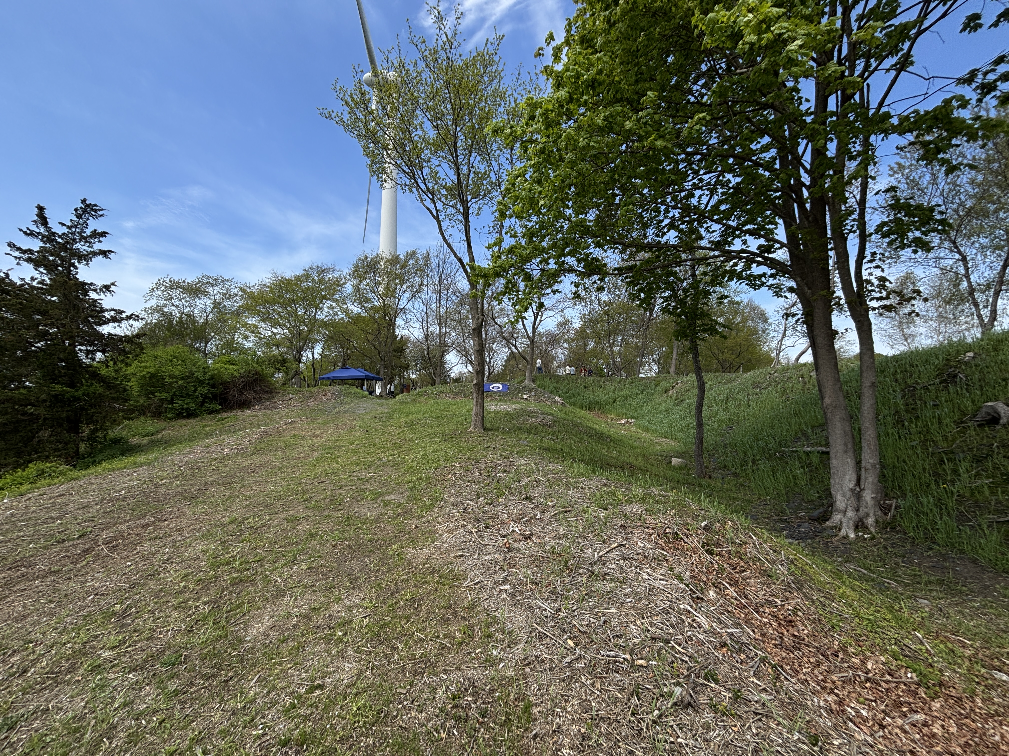
If you haven’t been to Butts Hill lately, this is an excellent time to go. This week we hosted 46 AP History students from Portsmouth High Schools on a tour of Battle of Rhode Island skirmish sites. We ended with a walking tour of the fort.
We hope to have better signage up in the coming year and full self-tour with QR codes. Meanwhile we have some resources to help explain what you see walking through the fort.
I have to go back to my blog on places Lafayette stayed during the Rhode Island Campaign and make a note that the 1760 farm house associated with Lafayette in Tiverton has been torn down. Through the years Portsmouth has lost many historic buildings. One of Jim Garman’s early books was on historic Portsmouth homes and he has noted when one of the houses he studied are lost to us.
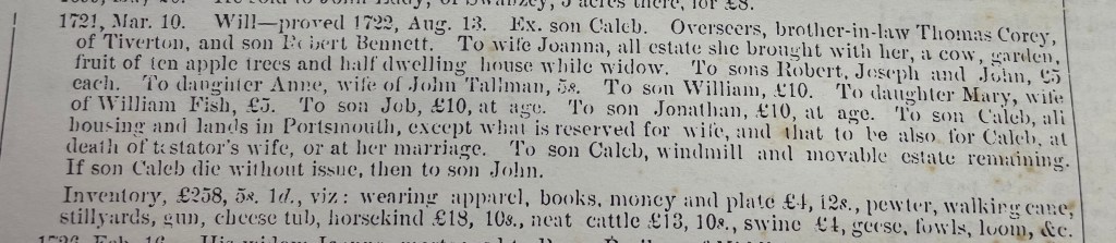
Within the last few years the Artemas Fish house on Glen Road (built circa 1760) was torn down to facilitate the building of new homes. Fish received a pension at Newport, Rhode Island, for eighteen months active service in Babcock’s Regiment, Rhode Island Militia during the American Revolutionary War. Babcock’s/Lippitt’s Regiment was a regiment raised for the defense of Rhode Island during the American Revolution. The regiment was one of two formed by the state of Rhode Island between November 1775 and January 1776 to deter an attack by the British against Rhode Island.
The regiment was again authorized by the Rhode Island General Assembly on January 8, 1776 with 12 companies under the command of Colonel Henry Babcock. The regiment was originally located on Aquidneck Island and along with Richmond’s Regiment left the island at the time of the British invasion.
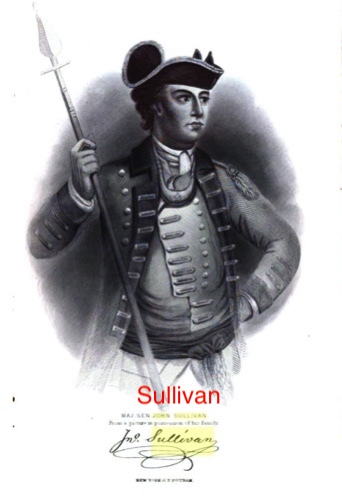
In his pension application when he was in his seventies, Fish listed his service during the Battle of Rhode Island – which he calls the Battle of Quaker Hill. Three witnesses for his pension application stated that Fish was part of Sullivan’s Life Guard. Sullivan sent this elite group into the thick of the battle at Quaker Hill.
..in the year 1778 he was employed, at least for six months, in the service in Capt. Joseph Knight’s company in the same regiment. He was much under Capt. Knight towards Sullivan’s expedition against Rhode Island – that he recollects that in the battle on Quaker Hill, besides the man who shot under him (near him?), & that on the evening of the second day after the battle, according to the best of his recollection, they retreated to Tiverton – that he also was a volunteer in Spencer’s expedition under the same Capt. Knight towards East Greenwich. Mentioned – that after the British left Rhode Island, he was often called out to guard, & in 1780 served for two months under Capt. Isaac Knight – that he was employed in actual service during the Revolutionary war for about twenty-six months. ” (Fish’s testimony in application for a pension can be found online – Fold3)
Artemas Fish had a long life. He served as Postmaster of Portsmouth 1808-1810. He died in February of 1834 in Rhode Island. His grave is in Fish Cemetery, Portsmouth, Newport County, Rhode Island, USA, Died at 90 in 1834,
The house became the property of Dr. Peter Wales, Portsmouth’s first doctor. The house was passed down to his granddaughter, Lydia, who was married to one of Portsmouth’s best builders – John Coggeshall. Coggeshall was the builder for the Christian Union Church, now the headquarters of the Portsmouth Historical Society.
The original settlers of Portsmouth were dissenters with Anne Hutchinson fleeing from Boston’s church rule. Portsmouth’s town seal proclaims “Founded on the Compact 1638.” Through the Compact twenty three men and their families agreed to form a secular government. Will and Edward Hutchinson (Anne’s son) traveled to Providence to Roger Williams who arranged a meeting with Narragansett Sachems Miantonomo and Canonicus. On March 24th they gave the sachems “a gratuity” of forty fathoms of white wampum beads, ten coats, and twenty hoes. The Narragansett removed themselves from the island, but selling land was not a concept in their culture. To the English settlers, this was a sale.
Pocasset Settlement
When they journeyed to Aquidneck Island, the Island was a wilderness and shelter was a big concern. They crawled into caves around the banks of the cove (Town Pond) where they landed. They followed the native’s example by bending birches into house frames, using mud for walls and weaving twigs to make a thatched roof. When the group of founders began their settlement, they called it “Pocasset.” It is an Algonquian word that refers to the width of the river, but it is also the name of the Pocasset Wampanoag Tribe of the Pokanoket Nation whose land included Tiverton and much of Southeastern Massachusetts..
Re-named Portsmouth
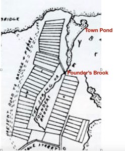
On May 12, 1639 the settlement’s name was changed to Portsmouth. The settlement of Pocasset/Portsmouth included the area around the Montaup Country Club, Town Pond, Founder’s Brook and south to Portsmouth Park. At this time the founders located their houses on small lots around water sources like springs and brooks. They were frightened by the sound of the wolves roaming around the camp. This was a major threat because livestock was unprotected. They brought with them horses, cows, sheep and hogs. While Anne Hutchinson and the others walked from Boston the animals were brought by ship around Cape Cod. With the aid of Roger Williams, members of the Narragansett tribe came and laid traps to kill the wolves. The settlers decided to make a Common Fence. Five rails with no more than three inches between each rail was judged sufficient to keep out predators. The first fence was built around the common pasture for the whole town and we know that today as Common Fence Point.
They were given land on the provision that they must built homes within a year. Town Pond was in the middle of activity. There were two springs that provided water – one was to the right of Town Pond near the Common Fence that held their animals. The other was by Founder’s Brook and that provided a central gathering spot and washing area. Baulston’s Tavern was located at the southern tip of the Pond. The Training Ground was across the way by the brook.
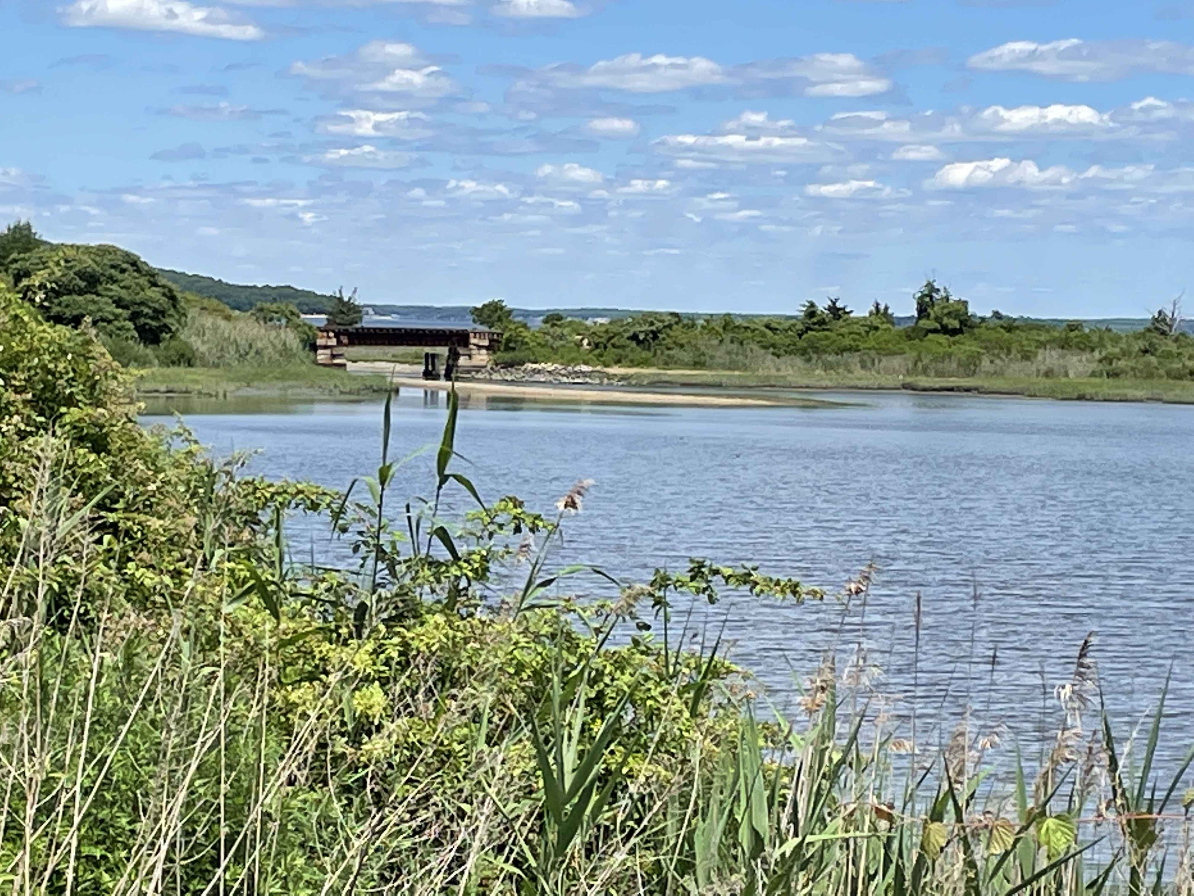
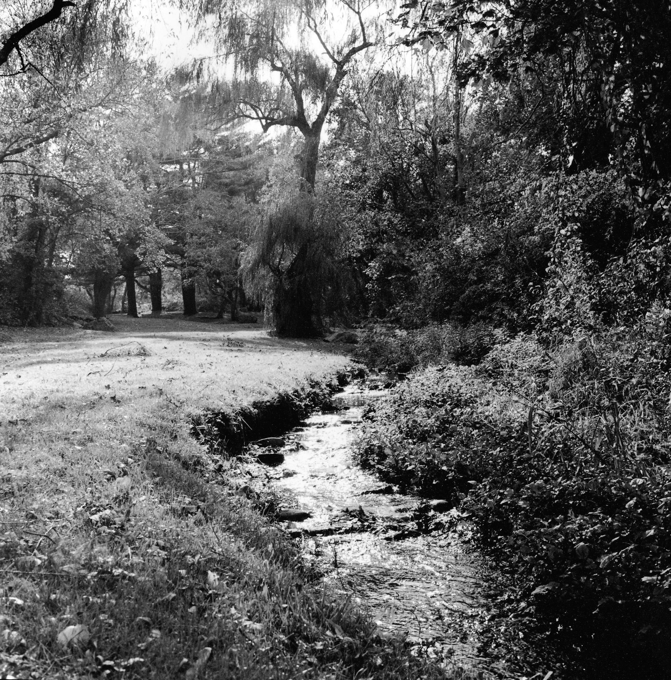
It wasn’t long before most of these settlers sold their house lots and moved out to their farm land grants. Town Pond and Founder’s Brook are worthwhile visiting today. The murmur of the brook and the bronze copy of the Compact at Founder’s Brook reminds us of the primitive life of the early settlers and their intention to band together as a political body. Town Pond can be viewed from a half mile hiking trail. The Pond has been restored to a tidal estuary, and you can imagine the scene as the founding families first stepped on Portsmouth ground.
Town PondSite were settler’s first gathered
Recommended reading: John Barry’s book on Roger Williams and the Creation of the American Soul.
Roger Williams played a great roll in the founding of Portsmouth.
For a number of years I have been gathering stories of Portsmouth women. Their stories can be forgotten when history is generally written about the men. In presentations I tell the story of Mary Paine Tripp, but John and Mary Tripp’s combined story gives us a glimpse of what was happening in the early days of Portsmouth. It also helps us to focus on what was happening in the Bristol Ferry neighborhood of our town. It was one of the first neighborhoods to be developed.
A story about Mary:
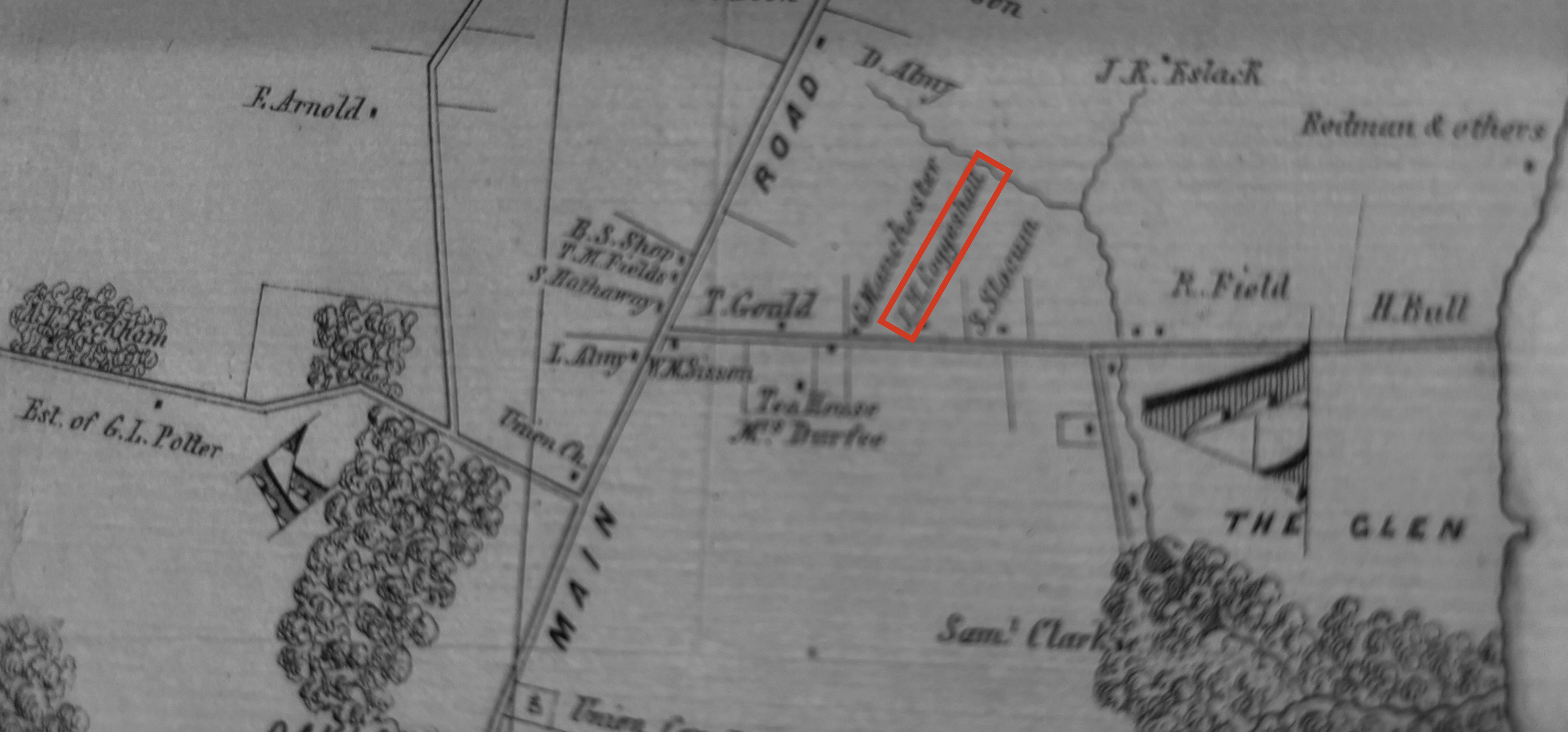
I came across an interesting story from Edward West’s 1932 article in the journal of the Rhode Island Historical Society on the “The Lands of Portsmouth, Rhode Island”. How much would you give for a glass of wine? Back in 1666 Richard Searl sold a three acre lot just above the Bristol Ferry to Mary Paine. Mary was the barmaid at Baulston’s Tavern and the land was exchanged for a “pint of wine.” Mary later married John Tripp who used the land for a ferry house. Although this deed wasn’t registered, the Town Council accepted the deposition of William Collinge as to how the land was transferred. Mary officially owned the land.
Note Searl Property on Land Grant Map. Marked with star.
John Tripp, early settler
An article by Tripp Family genealogist Janet Tripp Andrews provides us with information about John Tripp, 1611 – 1678, as well as the conditions in Portsmouth for the first settlers. John started life here as an indentured servant – perhaps to a ship’s carpenter. He was admitted as an “inhabitant” at Portsmouth’s founding. That allowed a settler to own land but not to vote or hold office. He must have paid off the indenture because a year later he was admitted as a freeman.
Early Records of the Town of Portsmouth show that the community developed quickly. The first house lots were assigned and an inn, brewery and general store were established with William Baulston in charge. Like all men between the ages of sixteen and fifty, John would have trained with the militia. To keep order a pair of stocks with a whipping post was ordered. To enable easier home construction a water mill was proposed. Meanwhile, that first summer settlers lived in caves or dugouts covered in branches. As wood was processed for construction more permanent one and two room structures with lofts and thatched roofs were considered permanent housing. Regardless of what their occupation had been in Massachusetts, the people of Portsmouth became farmers tending to hogs, goats, sheep and cattle. John Tripp, like the other Portsmouth settlers, would have been fencing property, digging wells, and planting orchards.
Although disagreements led to many residents leaving Portsmouth to establish Newport in 1639, John Tripp was among the thirty who signed the second Portsmouth Compact. He signed his own name. This was about the time that John Tripp married Mary Paine.
John Tripp would later become associated with boats and ferries, but Thomas Gorton was appointed ferryman to the Howland Ferry to Tiverton when it was established in 1640. Cattle were ferried across to graze in the Tiverton grasses. Early records show that in 1650 John had the approved weights to measure as the standard for the town. John took on other positions in town. In 1656 he was appointed to inspect cattle moving on and off the island. Tripp must have been able to read and write to do this job.
Meanwhile the Tripp family was growing. In 1640 their first son (John Jr.) was born. By 1650 their thrid daughter was born. Altogether Mary and John had ten or eleven children.
The process of becoming a “ferryman” was gradual for John. The shoreline around Bristol Ferry was owned by the town, but John Tripp, Ralph Earle and John Borden owned land that could add a pier. In 1658 the town treasurer was ordered to pay “Goodman” Tripp “for going into the Bay.” This could mean that Tripp was using his boat to deliver people and/or items like documents or goods.
In 1670 John Tripp had the honor of serving on the Governor’s Council. In 1673 John served as Town Moderator. With this service to the town and colony, Tripp was also serving as a ferryman. Captain Church’s writings have the first mention of “Tripp’ s Ferry” in 1676. After King Philip’s War Tripp’s son Abiel, William Earl, John Borden, and Joseph Anthony were given permission to build or finish wharfs on public land in 1682. Belore the Revolutionary War, the ferries were known by their owners – (Tripp’s Ferry, Borden’s Ferry). After the war it became know as the “Bristol Ferry” and was one of the most important ferries because it was a direct route from Newport to Providence. Washington, Lafayette, Rochambeau and other notables crossed to Bristol by way of this ferry.
Mary’s story continues
Mary Paine Tripp inherited John’s boats at his death in 1678. At a town meeting April 23, 1679 Widow Tripp was granted a license to sell food and drink to travelers. Perhaps she turned her house into a tavern. That would be full circle to her days at Baulton’s Tavern were she exchanged wine for a land grant.
Sources used:
Andrews, Janet Tripp. John Tripp, 1611-1678, A Glimpse into our Founder’s Life, Nov. 2016. In the collection of the Portsmouth Historical Society.
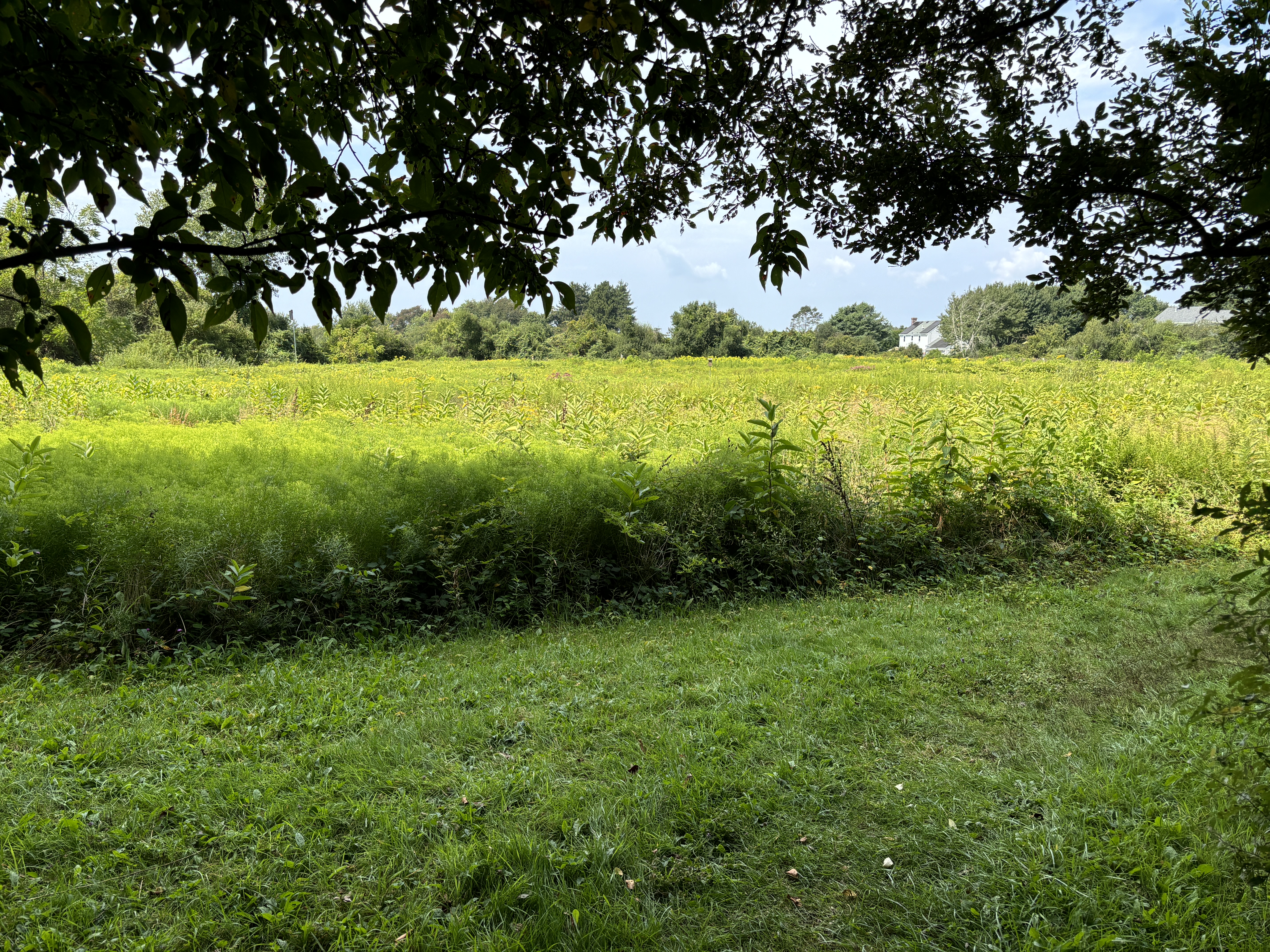
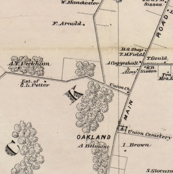
Today we took a gentle mile walk through Oakland Forest. On the walk you see a beautiful meadow and an old growth forest. This 30 acre area was saved for public enjoyment by the Aquidneck Land Trust through the generosity of local people. A developer was buying pieces of the property and building condominiums. Before the last section was sold off, forest scientists realized that the woods had the classic characteristics of old growth. Some of the trees were estimated to be 200-300 years old. The American beeches were 10 feet in circumference and 85 feet tall. There are white oaks in the forest that are 5 to 9 feet around and 70 to 80 feet tall. Considering that during the British Occupation of Aquidneck Island from 1776-1779 just about every tree was chopped down, having an example of “old growth” remaining is a treasure. Walking through the woods gives us an idea of what the land on Aquidneck Island was like when our first settlers arrived. There was a push by local people to preserve this forest instead of cutting it down for more house lots. Aquidneck Land Trust was able to buy this wooded area in 2000 for $1.5 million dollars.
The whole Oakland Farm property has quite a history to it. In the early 1800s Oakland Farm was the summer home of Sarah Gibbs and her sister Ruth Gibbs Channing. Ruth was the wife of William Ellery Channing, a famous Unitarian minister, and Oakland Farm was Channing’s treasured summer retreat. Sarah Gibbs is best known for her founding of St. Mary’s Episcopal Church in Portsmouth. Known as “Aunt Sarah” by her family, she was famous for her hospitality. Sarah never married, but at Oakland Farm she was surrounded by loved ones. Sarah was an integral part of the Channing family and wrote about the Channing girls as “my children.”
Later the property was owned by the Vanderbilts and was a magnificent Gentleman’s Farm with elegant stables and riding rings. Sarah’s home was expanded to suit the Vanderbilt needs.
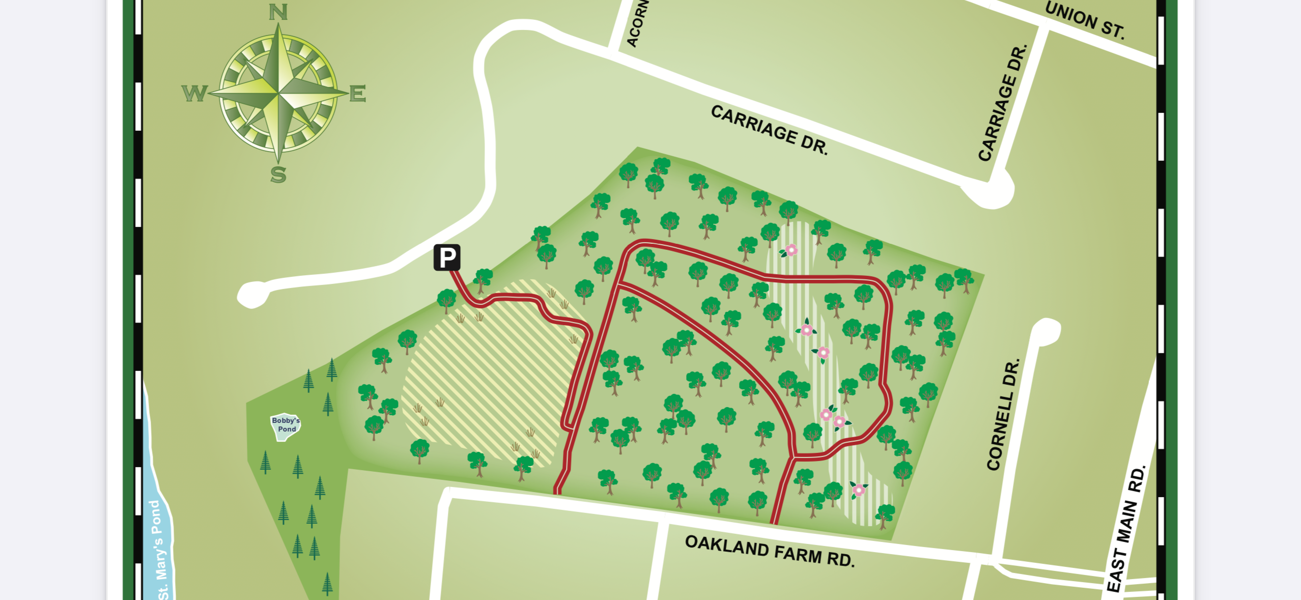
To access the woods: From the end of Union Street toward East Main Rd, turn onto Carriage Drive. Toward the end of Carriage Drive there is a small parking lot which marks the entrance.
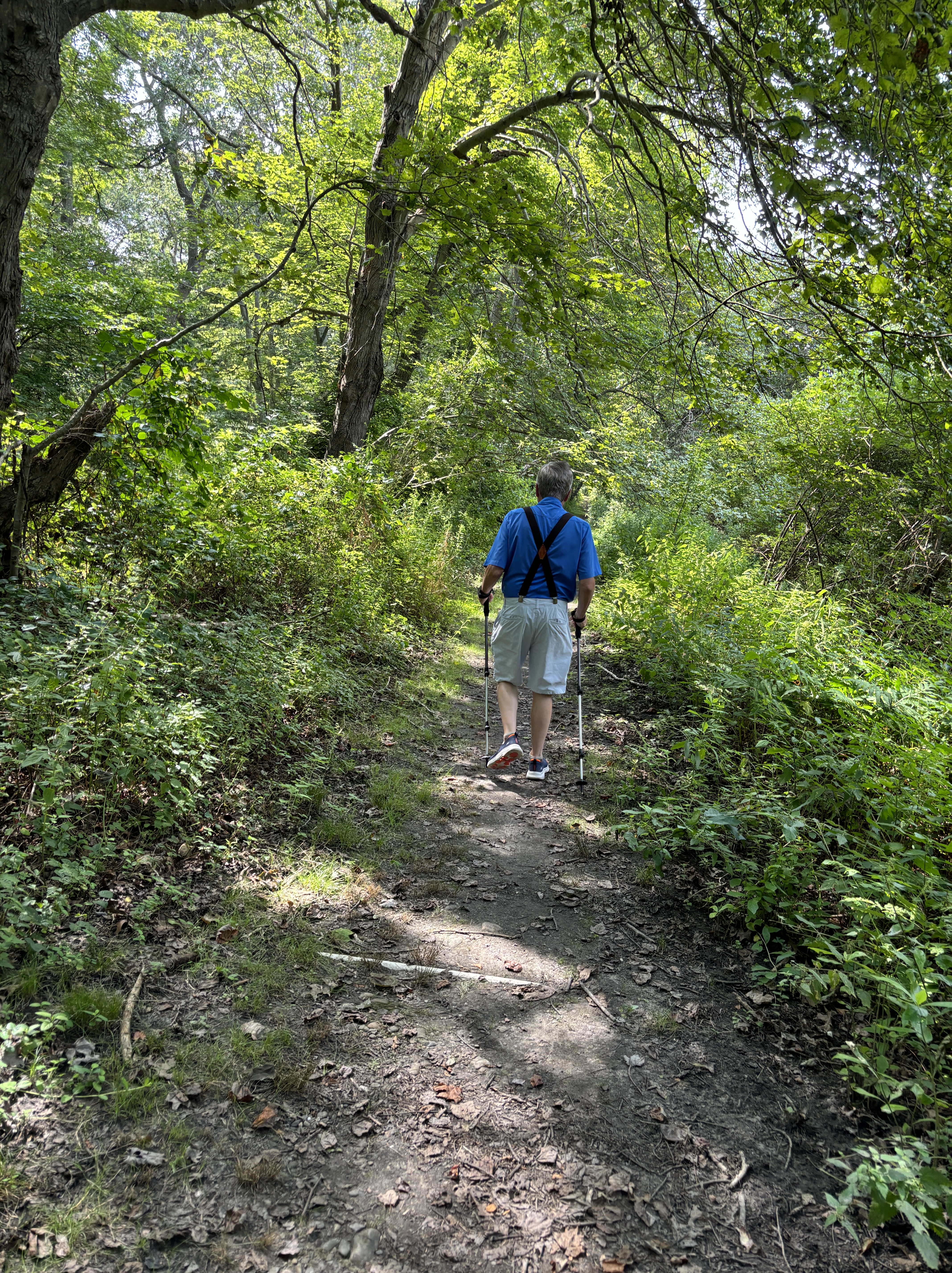
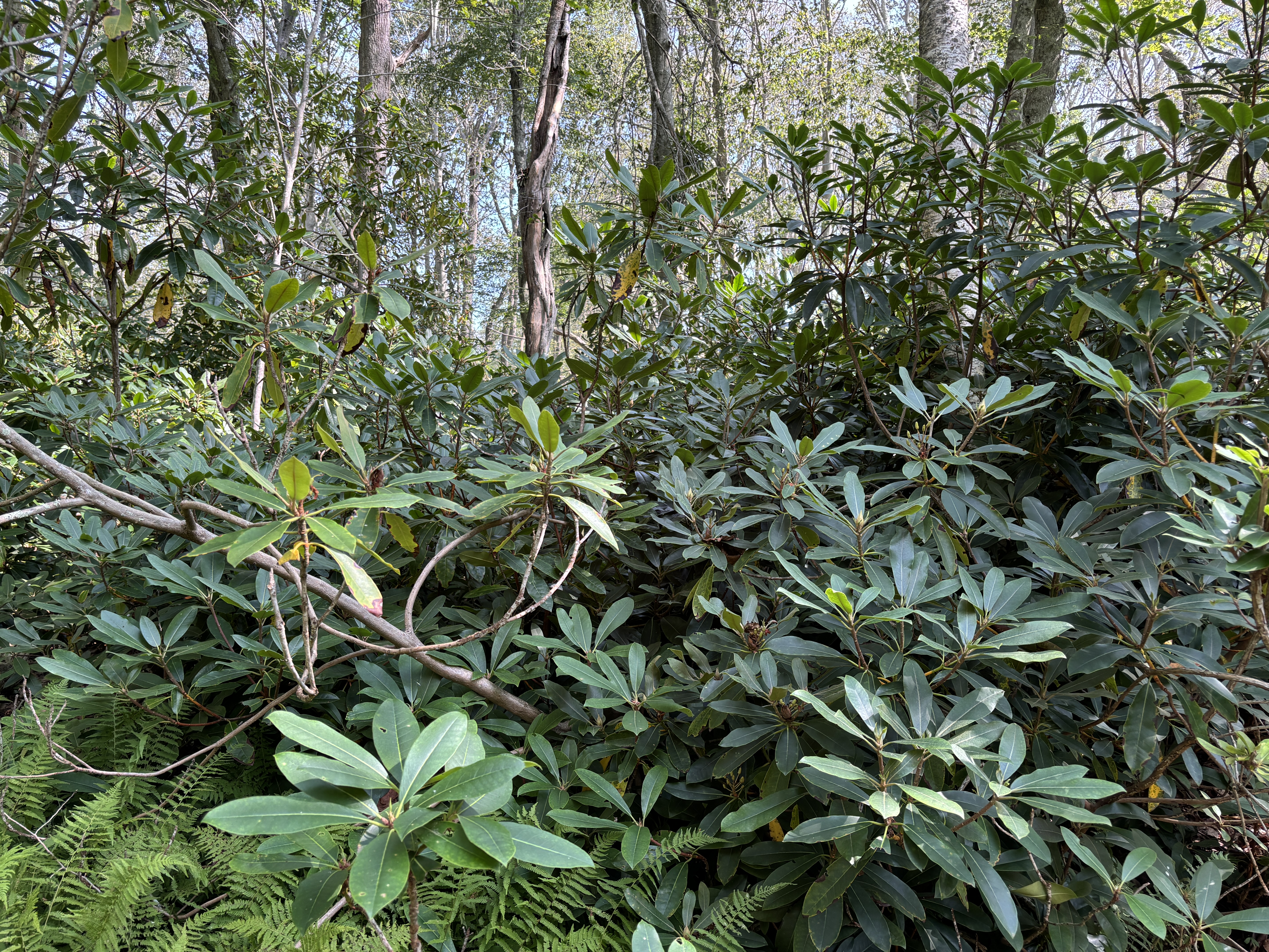
The early part of the trail is through a meadow. The access to the wooded part of the walk will be to your left. Follow the trail around the “Loop” and come back out where you began. In the wooded sections there are many tree roots and I would recommend using hiking poles for safety. Through the trail you will notice that part of the Oakland estate Rhododendron plantings are still there.
This is a work in progress as I uncover more dates of importance in the land history of the Butts Hill – (Windmill Hill – Briggs Hill) area. Working with the early dates is difficult.
Until 1638: The land on Aquidneck Island was a summer hunting ground for Wampanoags and later the Narragansetts.
1638 – Portsmouth town land.
1665 – Land owned by Caleb Briggs.
1666 – Windmill erected on Briggs Hill or Windmill Hill (from Preservation book).
1668 – Windmill completed by William Earle and William Cory.
1682 (Feb 24, 1682) – William Cory (carpenter and miller) in his will gave windmill to his wife Mary. Mary traded land back to the town.
1688 William Earle (Wm Cory’s brother in law) built windmill on Briggs Hill (I doubt this date unless this is a second windmill on the spot).
1721 – Caleb Bennett inherits windmill from father Robert Bennett. Robert had married Anne Cory – daughter of William and Mary Earle.
1725 (January) – John Butts bought from Caleb Bennett the windmill and about one rod of land (maybe a quarter of an acre) on Windmill Hill.
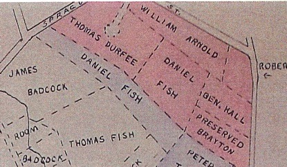
Before 1729 : Town gave a land grant to Thomas Durfee. West land-grant map shows windmill already on site. My suspicion is that town had held the larger parcels of land until this time. Windmill area small piece of that whole.
1729 (February): Town records show “a parcel called the Wind Mill Hill land” given to son Gideon Durfee. I suspect that there were several parcels of land on Windmill Hill. The West land-grant maps show that.
1776 – Americans built small battery at Butts Hill.
1776 to 1779 – British occupation of Island and fort.
1778 – July 29 to August 15 – Siege of Newport: British bring troops down to Newport. August 11: American troops at Butts Hill.
1778 – August 29-30 Battle of Rhode Island. Gen. Sullivan uses Butts Hill Fort as headquarters.
1778 – September 1, British return to Ft. Butts (known as Windmill Hill to them).
1779 – December – Butts Hill Fort returned to American control.
1780-1781 Camp Butts Hill housed French and American troops.
1782 Butts Hill Fort was abandoned by the end of the war (1782). 1900 House lots for sale – Benjamin Hall Jr. 1907 – Dyer family farm. Fort and surrounding platted for 200 house lots. 1908 – Benjamin Hall selling house lots
1920s -1930s. – Roderick Terry conveyed to Newport Historical Society, pieces of the land in 1923, 1924, and 1932. 1968 state transfers land to Town of Portsmouth.
House lots proposed 1910West land-grant map.Mary Cory inheritsCaleb Bennet inherits
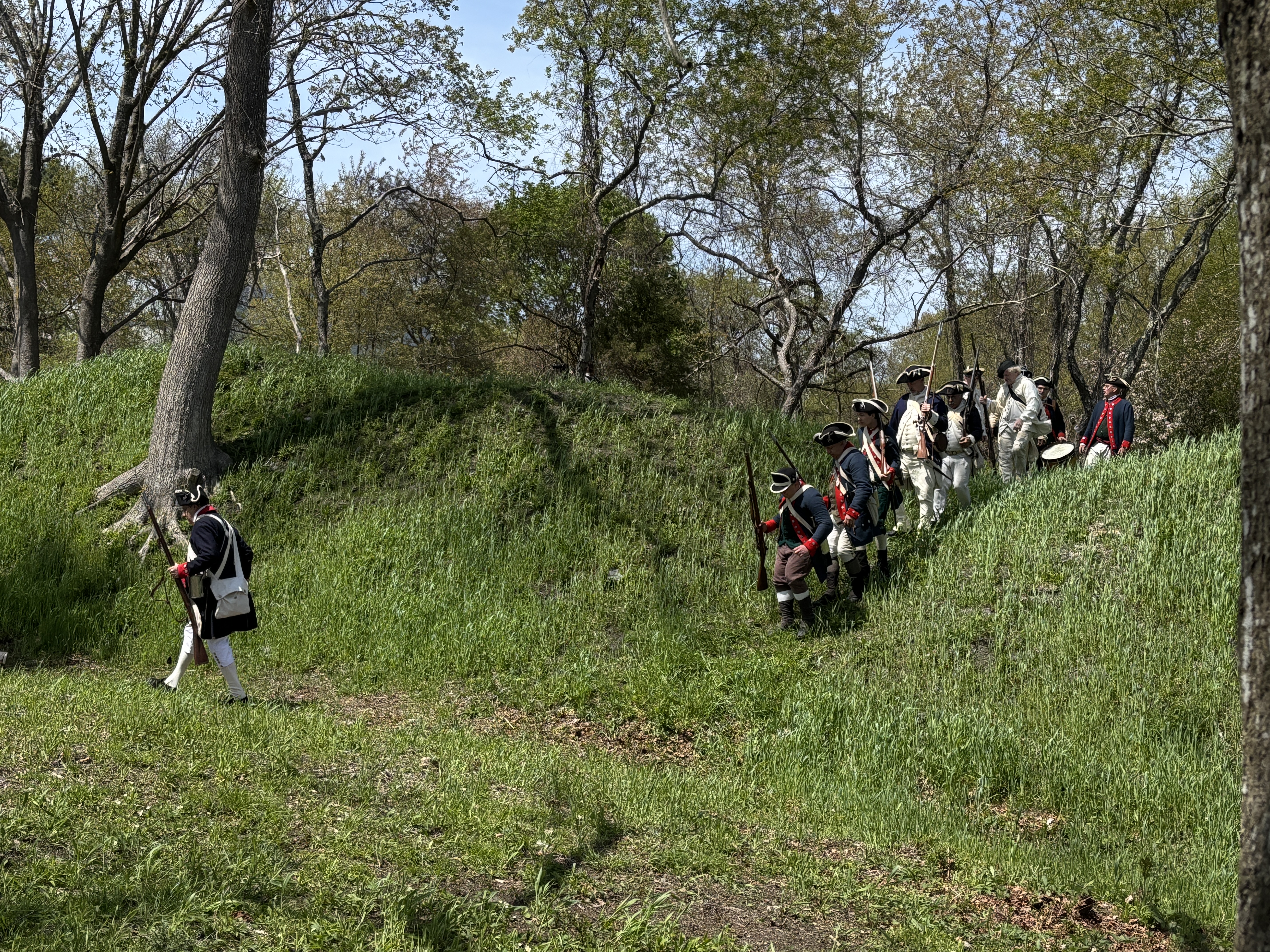
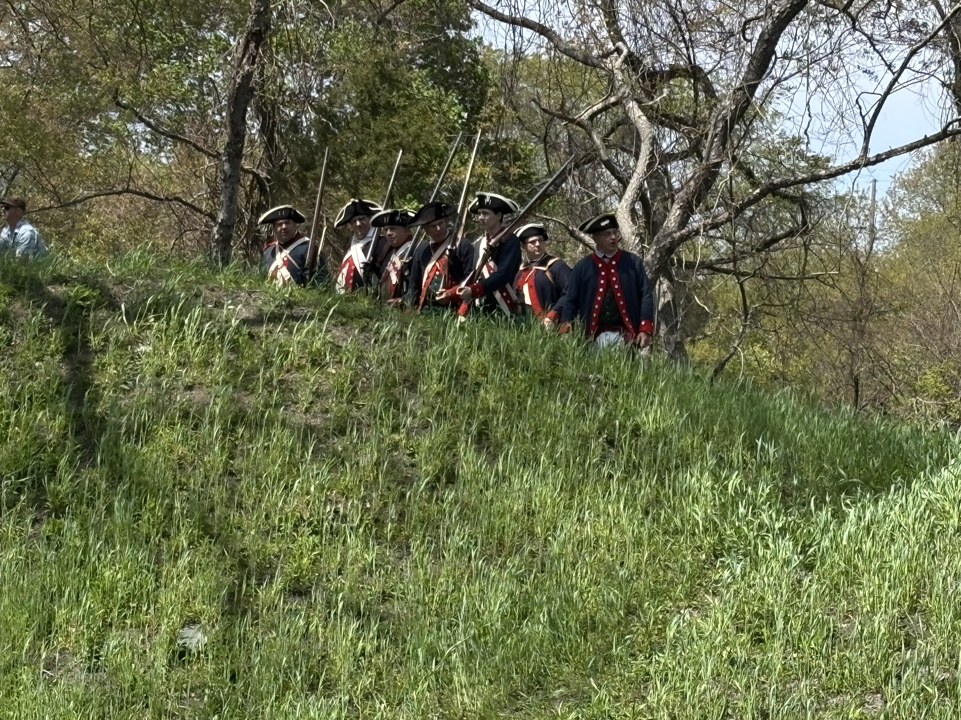
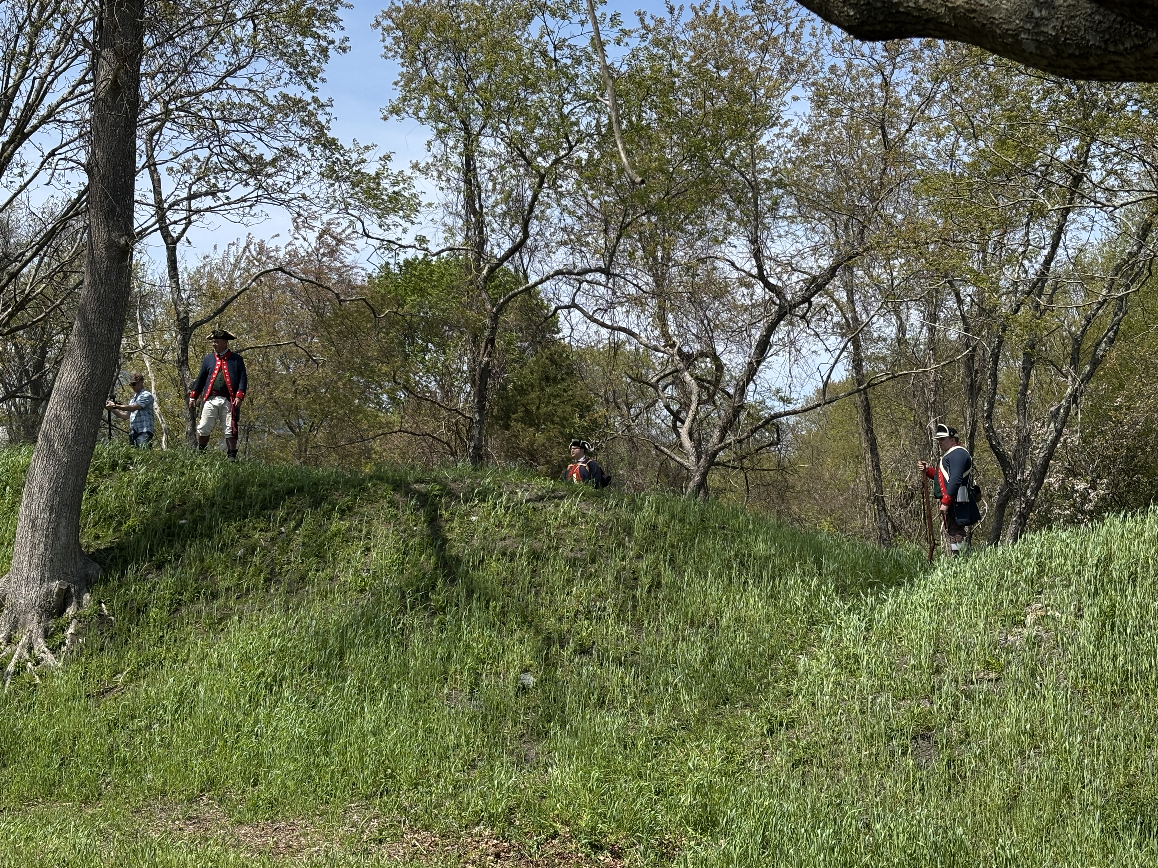
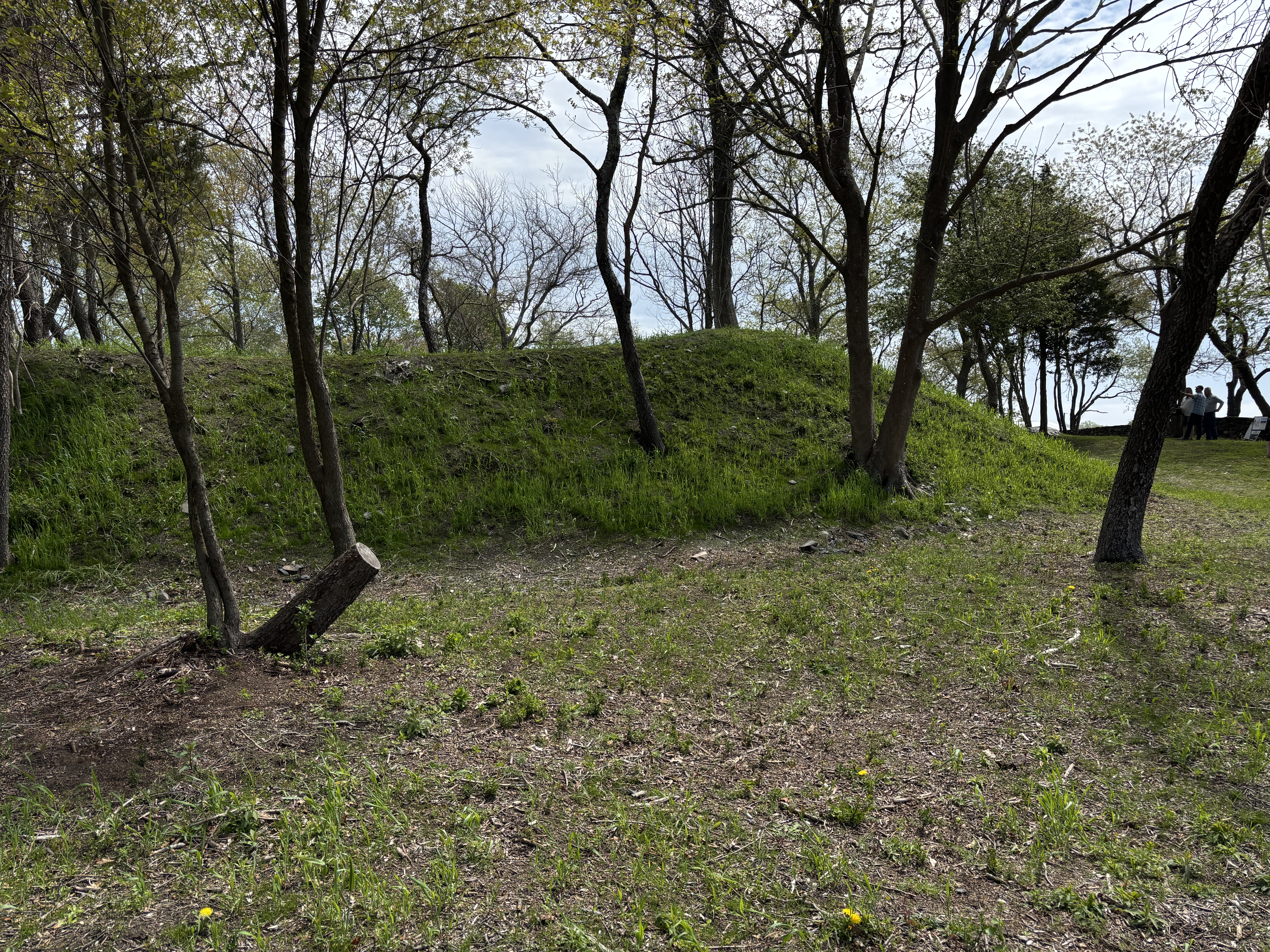
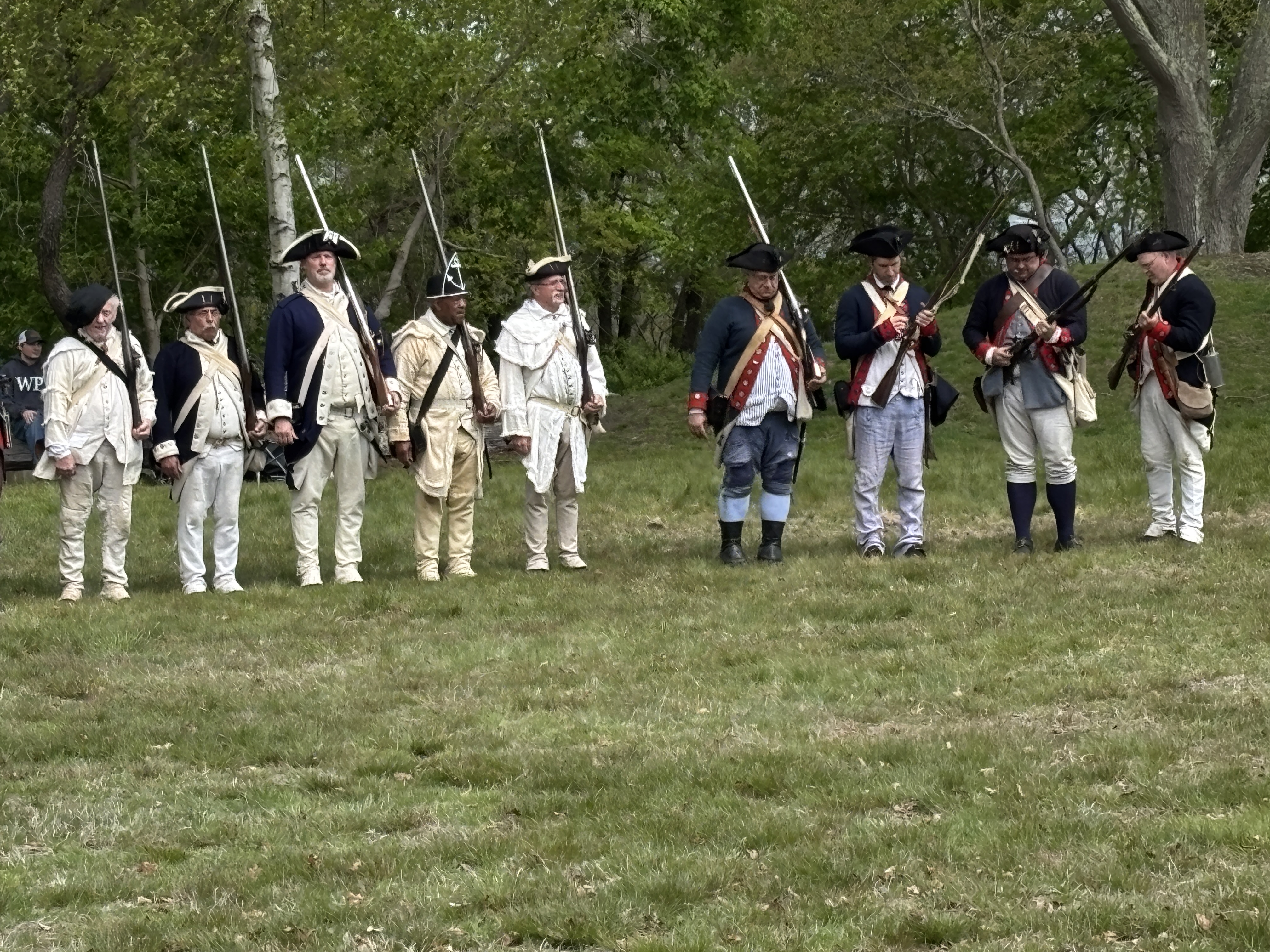
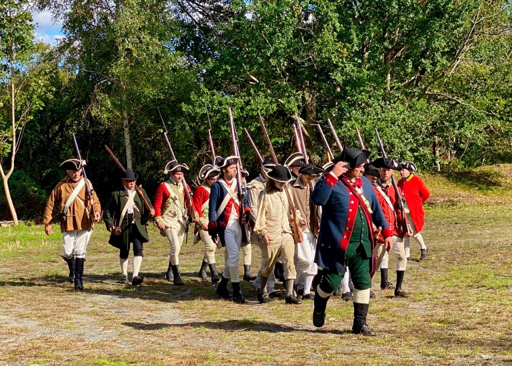
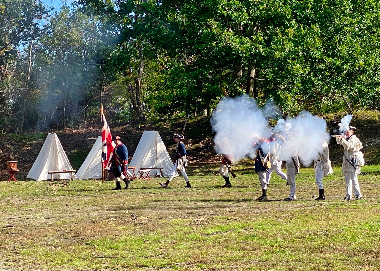
On Sunday, October 17, 2021, old Butts Hill Fort was lively once more. Re-enactors in Revolutionary era uniforms demonstrated the same military drills used in the War for Independence. It was a perfect example of what Dr. Roderick Terry had in mind when he donated the land around Butts Hill Fort to the Newport Historical Society in the 1920s. He envisioned a “place where the public may enter, view and study the battle field on which our soldiers fought, be enlightened in the battles thereon fought, and in American history.” Through the years the land passed into the hands of the Town of Portsmouth, but the town still has Terry’s mandate to use Butts Hill Fort as a public space where citizen can learn about the Battle of Rhode Island and our history. The Living History Day is a perfect example of how we can use the fort in the spirit it was given to us. Another mandate given was that the fort should be maintained. The Butts Hill Fort Restoration Committee (an outgrowth of the Portsmouth Historical Society) has been working towards a goal of clearing the vegetation that threatens the earthen fortifications. The committee has already begun to bring the fort out of the trees and bushes. There is much to do, but their goal is to preserve this historic battlefield, create a park with walking trails around it and prepare it for Revolutionary War celebrations around 2026. Visiting an historic site is certainly a valuable way to learn our history and the committee is doing the research to create informative signage and educational stations. How can we use this historical gem in our community? A gathering spot for community celebrations, for scout activities, staging area for re-enactments, and opportunities for heritage tourism are just some ideas that come to mind.
Images of Living History Day by Joseph Studlick
Are you interested in volunteering for some cleanup or other activities? Email Seth Chiaro at seth.chiaro@gmail.com.
Prescott Farm (Overing House) West Main Road at town line.
At this site, British General Richard Prescott’s was captured in July 1777, Colonial militia, led by Colonel William Barton, made the daring night raid. The site is owned by the Newport Restoration Foundation. Besides the Overing House (1730) it includes relocated Portsmouth colonial homes: The Hicks House (1715) from Bristol Ferry Road and the Sweet Anthony House (1730) from West Main Road.
Vintage image of Overing House
View of house from Prescott Farm
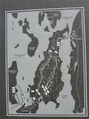
2. Patriots Park West Main Road at split with Route 24.
Memorial to the 1st Rhode Island Regiment, known as the “Black Regiment” located at the junction northbound of Routes 114 and 24. Flagpole commemorates the site where the Black Regiment courageously fought off a Hessian attack, saving the American line, on August 29, 1778 during the Battle of Rhode Island.
Battle of Rhode Island map at Patriot’s Park
3. Bristol Ferry Town Commons and Mount Hope Park (old ferry landing) End of Bristol Ferry Road at Bayview
This is the site of a town common dating back to 1714. Ferry service started here in 1640. This 1.5 acre space was originally used by farmers and others to keep their livestock and other goods while waiting for the ferry to Bristol. The ferry landing had a British fort during the occupation.
Bristol Ferry Landing 1929
Bristol Ferry Town Common today
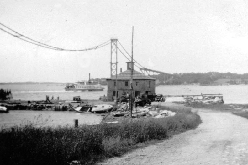
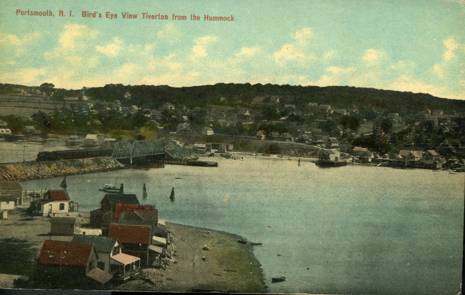
4. Stone Bridge area Park Avenue
Site of bridges to Tiverton dating back to 1795. Nearby is the location of Howland Ferry to Tiverton which was one of the ways the Patriot forces left Aquidneck Island after the Battle of Rhode Island. The British had a fort here during the Occupation of Aquidneck Island.
Vintage view of Howland Ferry Era
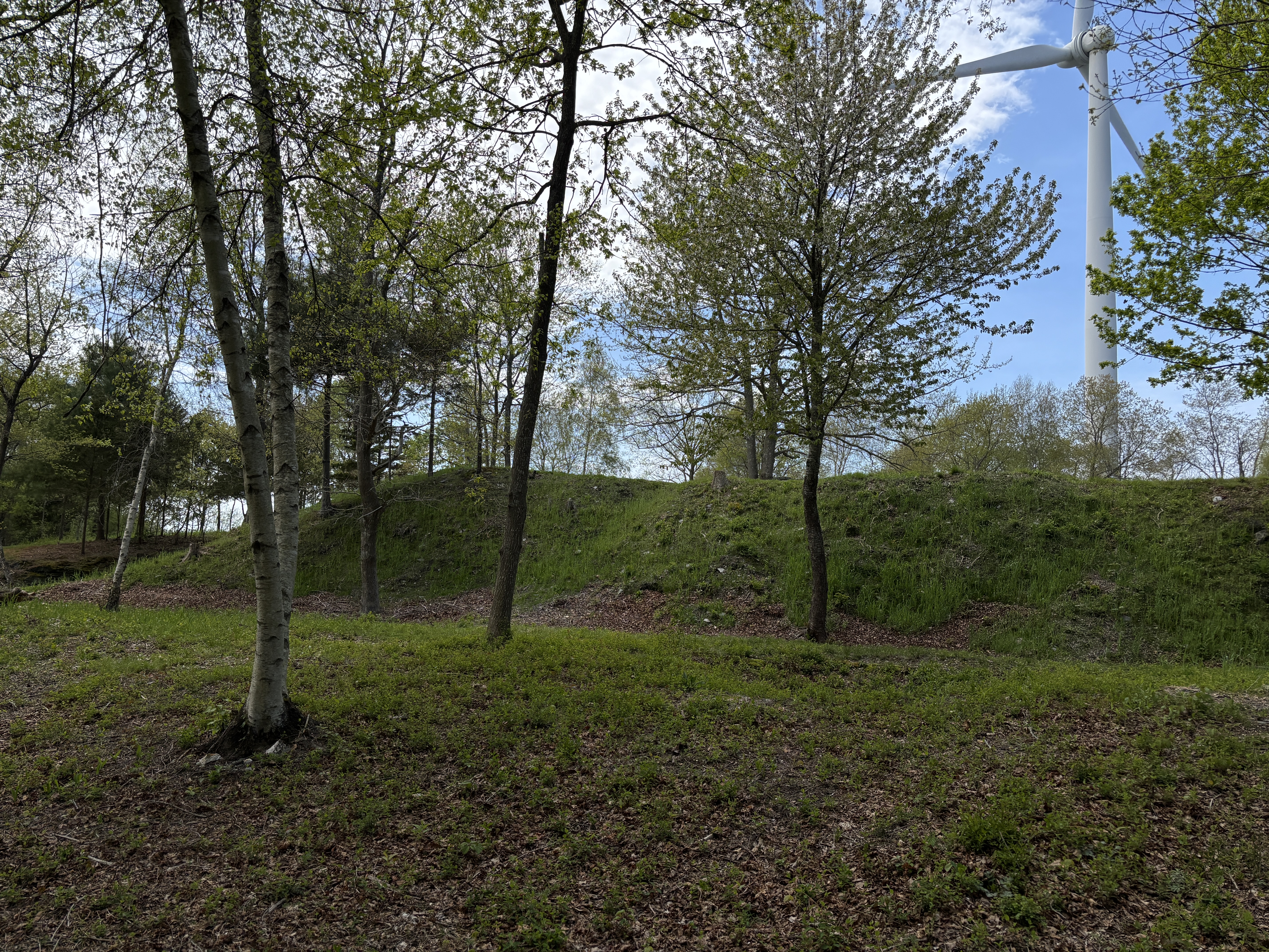
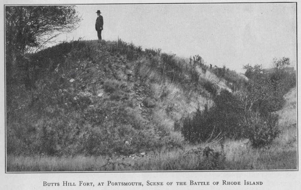
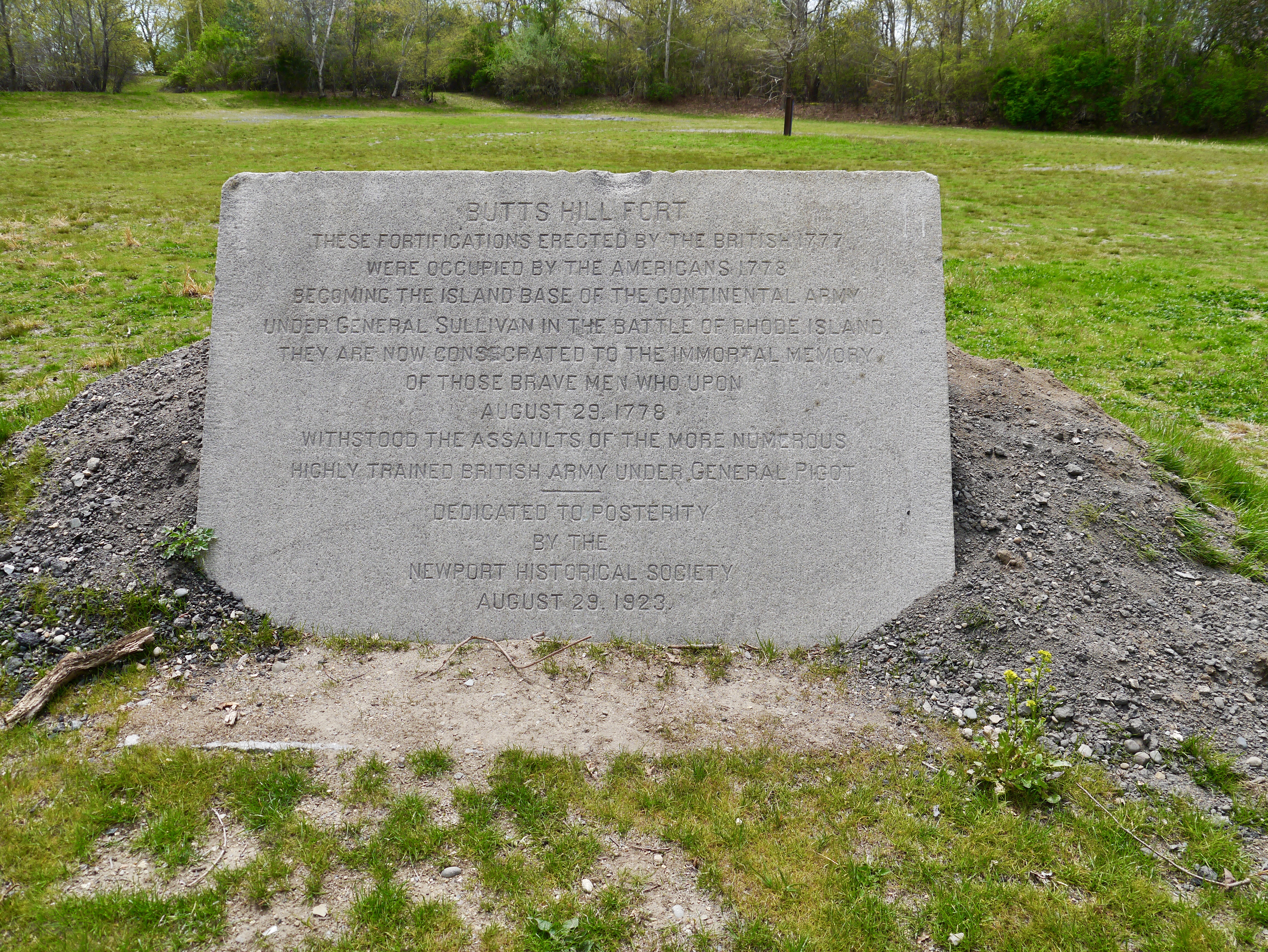
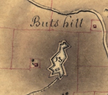
5. Fort Butts Off Sprague Street
In 1776 the Americans built a small battery on Butt’s Hill. The British and Hessians occupied the fort in December of 1776 and enlarged it to hold barracks for 200 men. During the Battle of Rhode Island in August of 1778, the fort was an American strong hold and the whole battlefield could be seen from this position. After the British left, French forces and portions of the Rhode Island First Regiment repaired the fort.
Monument at Buttys Hill Fort today
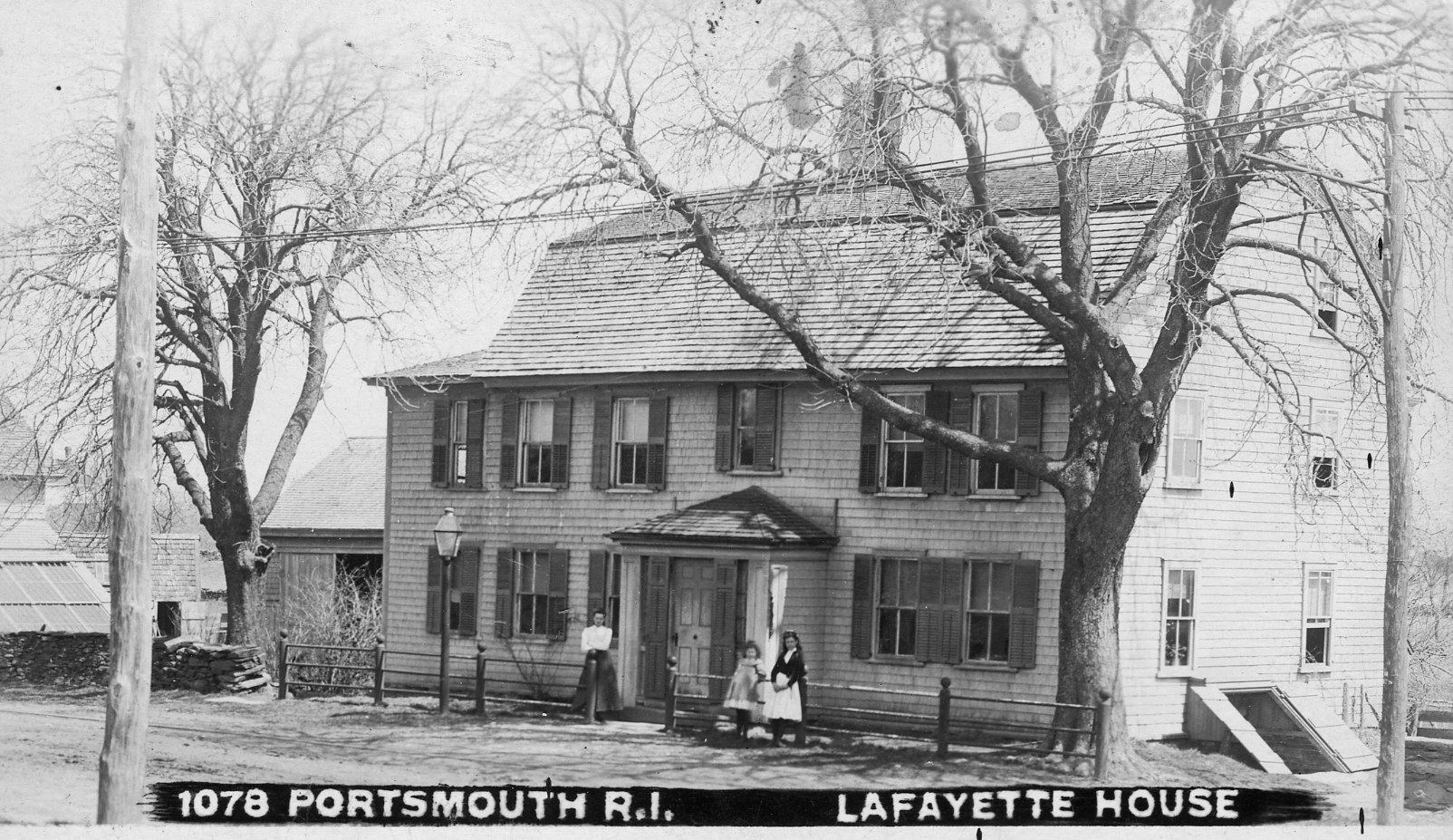
6. Lafayette House 2851 East Main Road
Also known as the Joseph Dennis house (1760), French General Lafayette stayed here just before the Battle of Rhode Island.
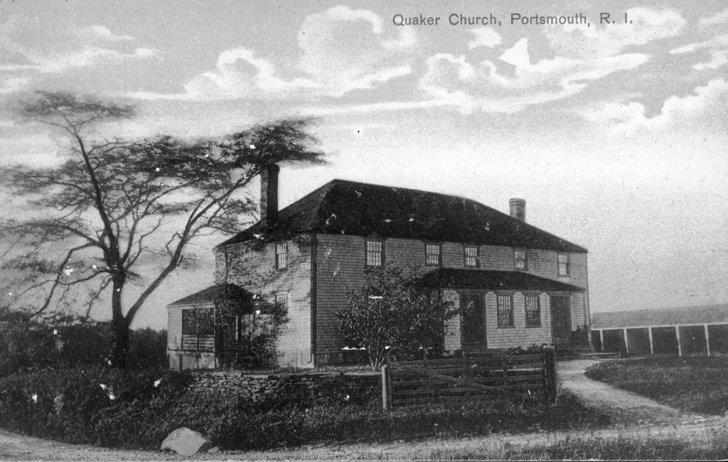
7. Friends Meeting House Middle Road at Hedly St.
The Portsmouth Society of Friends was founded in 1658 and this Meeting House was completed in 1700. It is now known as the Portsmouth Evangelical Friends Church. This building was occupied by the British and was a central part of Quaker Hill action in the Battle of Rhode Island.
Quaker Meeting House circa 1700
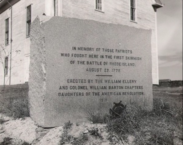
8. Historical Society Museum Corner of East Main Road and Union Street.
The state’s oldest schoolhouse, Southernmost School (1725) is on the grounds of the Portsmouth Historical Society as well as a monument commemorating the first volleys of the Battle of Rhode Island.
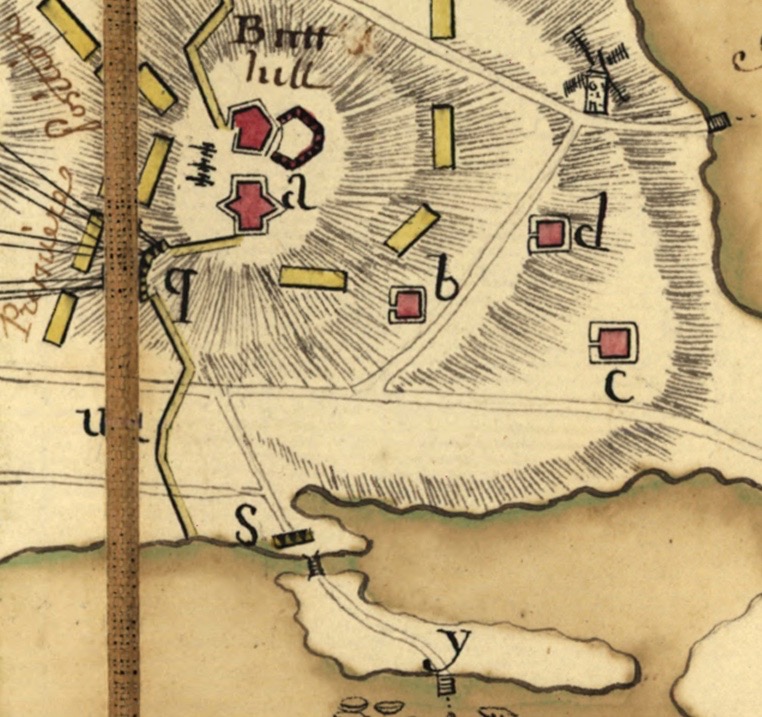
As we look to restoring Butts Hill Fort, one question that comes up is how the fort developed in the first place. The Diary of Frederick Mackenzie * in combination with the Revolutionary Era maps of the area give us an idea of how Butts Hill Fort (Windmill Hill Fort) developed over time. Military historians will have a better handle on construction methods, but the diary, maps and blueprints can help us to understand what we see at Butts Hill today.
December 8, 1776: as Mackenzie was arriving on the island as part of the British forces, he wrote: “The Rebels abandoned a well situated fort at the N. End of the Island yesterday, without attempting to defend it. It in some measure commands the passage to Bristol by the ferry.” My guess is that this is a reference to the Butts Hill (or Windmill Hill location as the British called it). The location does overlook the Bristol Ferry landing.
Dec. 30, 1776: The redoubt constructed by the Rebels above Bristol Ferry, and abandoned by them, is ordered to be repaired and a guard house to be erected therein for the accommodation of the advanced post. It is a much better situation for the advanced guard than that they are now in, and the troops on duty will not be liable to accidents from the wanton firing of the Rebels on the opposite side. This again I believe to be a reference to the Butts Hill Fort in the area “above Bristol Ferry.” The Rebels had fortifications across in Bristol and they would often direct fire at the troops stationed by the Aquidneck side of the Bristol Ferry crossing. The order here is to repair the redoubt and build a guard house.
Sept 12, 1777: As the works intended to be made for the defense of the North Part of the Island, require a good many workmen to complete them, and the duty of the Soldiers is rather severe, General Pigot sent a summons this day to the Inhabitants of the township of Portsmouth to assemble on the 15th instant at Windmill Hill in order to assist in carrying them on. They are required to work three days in the week.
Sept 15, 1777: In consequence of the General’s summons to the Inhabitants of the township of Portsmouth, to assemble in order to be employed to work on the Redouts, 17 only appeared this morning at the place appointed. The Majority of the Inhabitants being Quakers, they informed the General that it was contrary to their principles to assist, in any manner in matters of War, and that therefor they could not appear. They even refuse to be employed in constructing Barracks for the accommodations of the troops.
Sept. 17, 1777: We are at present very busy in fortifying different posts on the Island; and there are already more works planned and traced out, than can possibly be finished by the end of December. Those intended are a redoubt for 30 men and 2 cannon opposite Howland’s bridge. A fortified Barrick on Windmill hill for 200 men. A Redoubt on Barrington’s Hill for 80 men and 2 cannon. A redoubt at Fogland Ferry for the like numbers. A redoubt on Quaker Hill and a Barrack there for 200 men. A redoubt and Barrack for 60 men on Turkey Hill.
From these passages it appears the barracks at Windmill Hill were constructed beginning in September of 1777 with forced labor from the Portsmouth townspeople. Windmill Hill and Butts Hill are different names for the same area.
Nov. 11, 1777: The Barracks at Windmill-Hill go on so slowly for want of materials, that there is a prospect of the troops remaining in camp for three weeks to come.
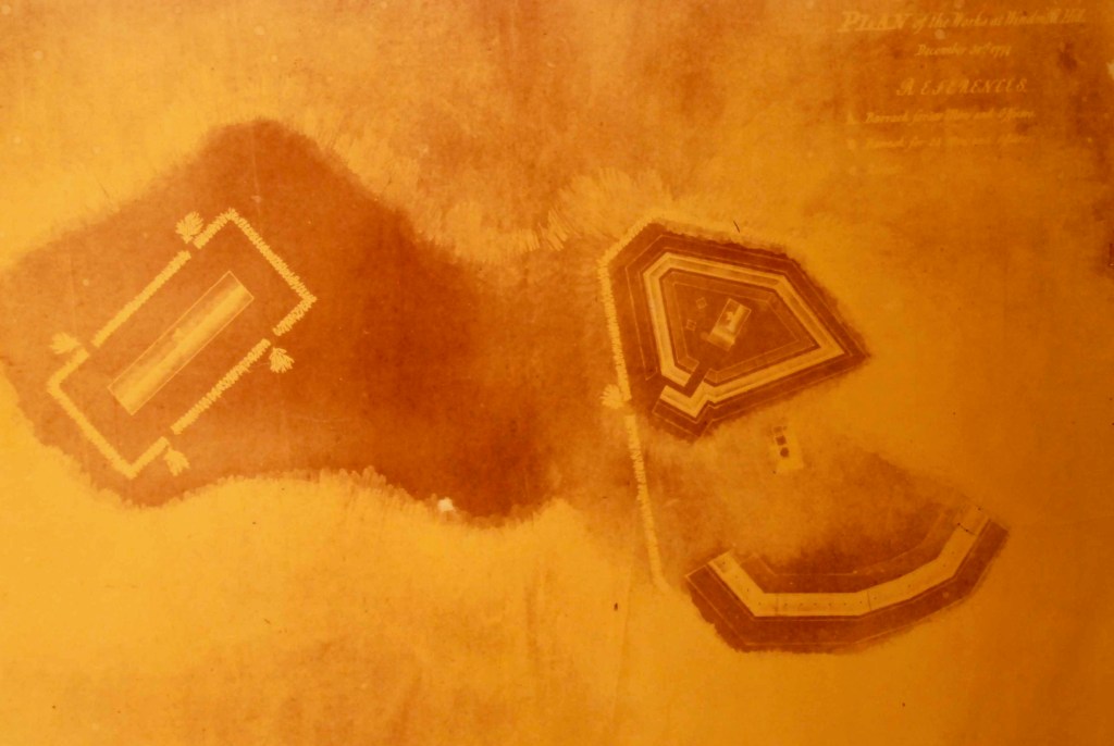
Obviously the barracks were sorely needed but the construction was slow. Historian Walter Schroder in his book about the Hessian troops says that by the end of 1777 there was a battery with six guns at Windmill Hill as well as a redoubt for 100 men. A separate barracks for 300 men and officers had been constructed close to the other barracks. He writes: “The entire area encompassed earthworks some 700 feet long by 200-300 feet in width. Abbatis – an entanglement of cut tree limbs serving a role similar to barbed wire in modern times –had been placed outside the entrenchments and earthworks to slow down and harass advancing enemy foot soldiers. **
April 18th, 1778: As we have at present no camp equipage (except some old tents for about 500 men) I think we should immediately erect a respectable work on Windmill Hill, capable of containing a Regiment, and not to be taken without breaking ground against it. The enemy should by every means in our power be prevented from establishing themselves unmolested on Windmill Hill, or any part of the Northern extremity of the Island, for if they should we shall find it extremely difficult to dispossess them…
..A trifling temporary work should by no means be constructed on Windmill Hill; to as it is the best spot on the Island for a work of consequence, and such a work will at one time or other be found necessary there, the erection of a trifling work would be throwing away so much time and money.
It is clear that Mackenzie considered Windmill Hill (Butts Hill) and important location and thought it should be well developed as a defensive fort.
May 1, 1778: The 54th regiment are to construct a Redoubt round the Barrack at Windmill Hill, for the present security of that post.
May 5, 1778: The 54th Regiment is employed at Windmill Hill in throwing up a work round the large Barrack there.
Here it seems like there is a defensive perimeter built around the Barracks and guard House. This gives it the outline that we can even see today.
May 8th 1778: The regiments of Landgrave and Ditfourth to be posed at Windmill Hill; under the Command of Major General Losbert. They consist of near 1,000 men, their field pieces would be of great service there, they may be depended upon for the defense of the works. And Major General Losbert is the Second in Command on the Island.
It is hard to imagine a thousand soldiers at the fort. Some would be in the barracks and some would be encamped around it.
1780, July: The French arrived on Aquidneck Island. Before they had settled, there was news the British were planning to attack. Washington authorized Rochambeau “to call up the militia of Boston and Rhode Island to aid his army build the works for the defense of the island.”
The Black Regiment was split between guarding munitions in Providence and guard duty on Aquidneck Island. Sixty-four members of the regiment were sent to Newport and were incorporated into the “Rhode Island Six Months Battalion.” The Black Regiment veterans were among the 600 men encamped in Portsmouth guarding Butts Hill Fort, Howland Ferry and Bristol Ferry. One white recruit, Peter Crandall, wrote: “We landed on the north end of the island near Butts Hill Fort and pitched our tents on a height of land near Butts Hill Fort …. our duty was to go through the manual exercise, keep up quarter guard, and work on the fort.” This remnant of the Black Regiment and The Six Month Battalion were there until Nov. 1780. They remained at Butts Hill to work on the fort after the remainder of the Continental Battalion joined French troops in marching to join Washington’s army. *** In the summer of 1780 they connected the redoubt and the former British barracks into one structure.
From French map 1780
British (Fage) 1777
French map 1778
Sources:
*Diary of Frederick Mackenzie Vol. 1 and Vol. 2. Cambridge, Massachusetts, Harvard Press, 1930.
**Schroder, Walter. The Hessian Occupation of Newport and Rhode Island 1776-1779. Westminster, Maryland, Heritage Books, 2005. pg. 102.
***Kopek, Daniel M. They “fought bravely, but were unfortunate:” The True Story of Rhode Island’s Black Regiment.
Edward Fage – Plan of the Works at Windmill Hill, Dec. 31, 1777 (facsimile in PHS collection)
Plan de Rhodes-Island, et position de l’armée françoise a Newport. Library of Congress Collection.
Plan de Rhode Islande, les differentes operations de la flotte françoise et des trouppes Américaines commandeés par le major général Sullivan contre les forces de terre et de mer des Anglois depuis le 9 Aout jusqu’a la nuit du 30 au 31 du même mois que les Américains ont fait leur retraite 1778