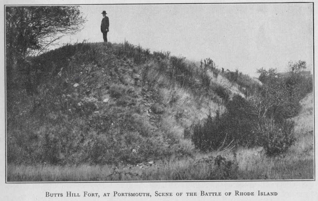
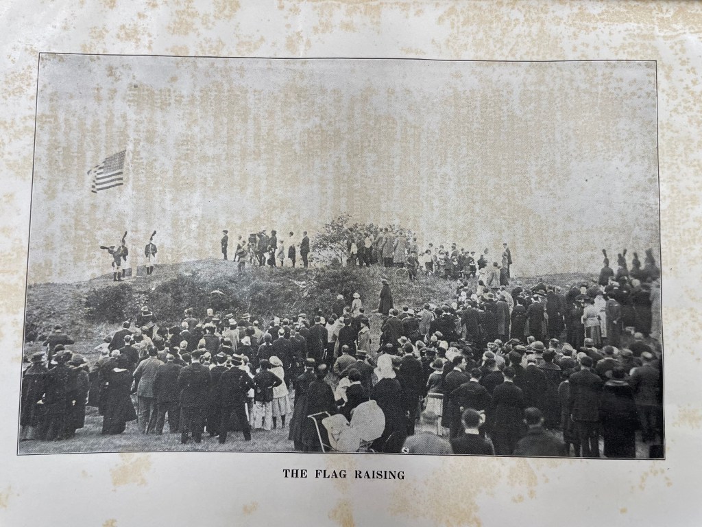
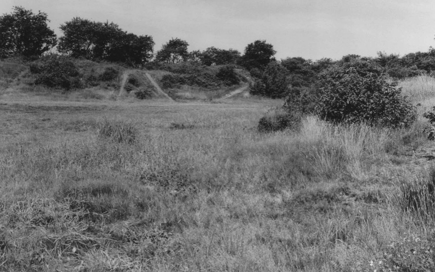
It is difficult to understand what you can see today at Butts Hill Fort. The landscape doesn’t quite make sense, but if you are fortunate to have a knowledgeable guide with you, you can imagine the fort as it used to be. Fortunately for me, the first time I saw the fort I was guided by Dr. Kathy Abbass and she understood the fort. At that time (2008 or 2009) Dr. Abbass was advocating for a restoration of the fort and I was the board member of the Portsmouth Historical Society assigned to see how we could work with her. I was overwhelmed with the moats and sloping hills (glacis), and it seemed incredible that the fort could be in Portsmouth and I hadn’t known about it. I did some research on the Battle of Rhode Island, but Abbass’ proposal seemed to go nowhere. I picked up my research again as the Butts Hill Fort Restoration Committee developed last year.
One goal I have is to help Portsmouth residents (and others) to understand what they see when they come to the fort. There is nothing better than a “field trip” – actually being at an historic site. The Butts Hill Fort Restoration Committee is working towards a time when there are marked trails, observation posts, signage and QR codes. Right now those things are admirable goals (that take planning and money). What I am trying to work out is how I could give a knowledgeable tour to a group coming in May or June of 2022. These next blogs are part of my brainstorming of materials I would need to write a tour script.
One thing I know from my research is that the Butts Hill Fort (or Windmill Hill Fort) evolved along the way. The outlines we are seeing date from the improvements made by the French (with the help of Americans) in 1780-1781.
Parts of the Fort:
Before I even begin I need to get my terms straight. My knowledge of military terminology is limited, but I am learning. The definitions I am using are adapted from the American Battlefield Trust and other military websites.
Battery: A fortified emplacement for heavy guns or artillery pieces; companies of artillery usually had six to ten guns used together or dispersed based on the situation.
Rampart: A large earthen mound used to shield the inside of a fortified position from artillery fire and infantry assault.
Glacis: A defensive feature which is simply a natural or artificial slope incorporated into the defenses of a fortification. The slopes were initially designed to deter attack on foot with steep man-made slopes
Moat: A depression surrounding the fort. Often the moat was created as a natural result of early methods of fortification by earthworks, for the ditch produced by the removal of earth to form a rampart made a valuable part of the defense system.
Parade Ground: Place where soldiers practice or have parades.
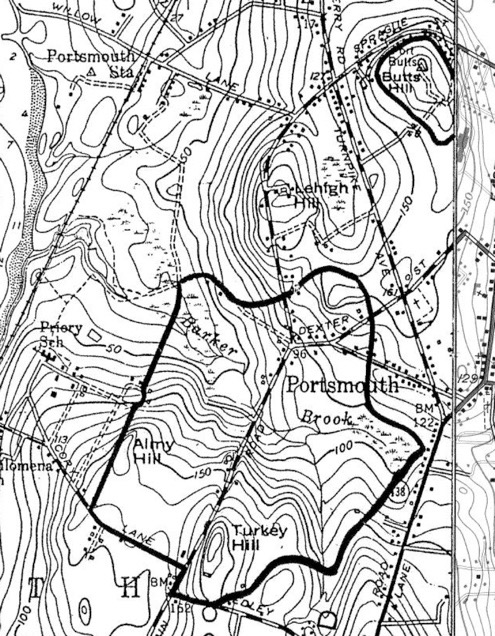
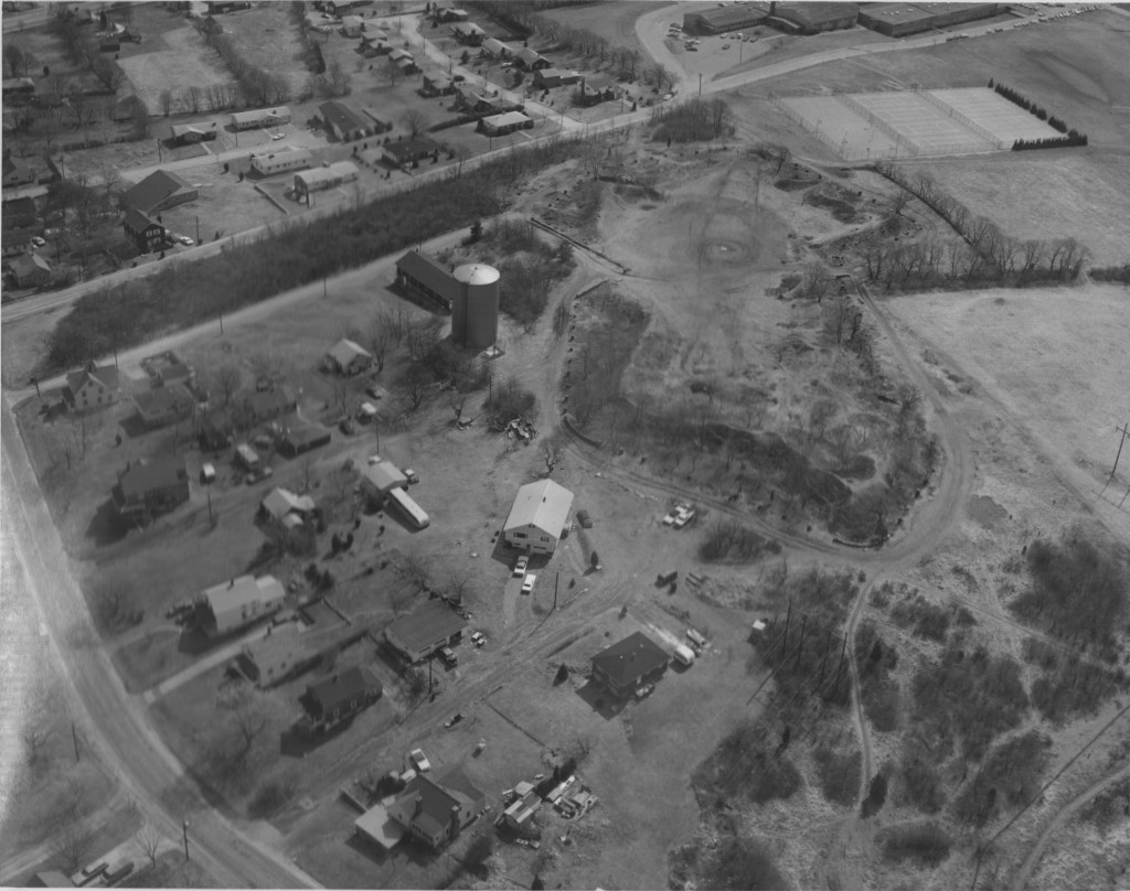
Dr. Abbass’ plan contains some helpful maps that help us understand the fort as we view it now. I tried to simplify a map that is an overlay of the fort outline on current terrain.
Overlay of TerrainMap from Abbass’ proposal
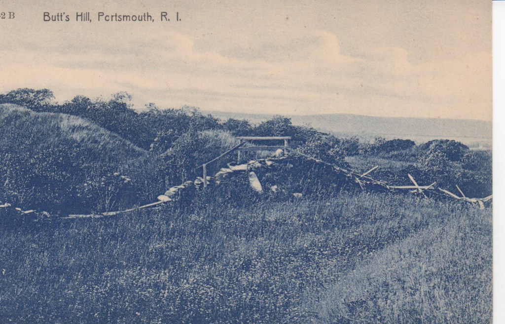
North battery ramparts: The oldest portion of the fort. It is intact except for its south wall which opens to the parade.
North Battery
South battery ramparts: The north, south and east faces of this battery’s ramparts are basically intact. The West ramparts were removed during the expansion of the fort when the French and Americans modified it (1780-1781).
Volunteers clearing South Battery Ramparts 9/2021
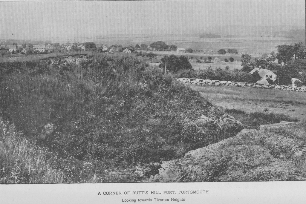
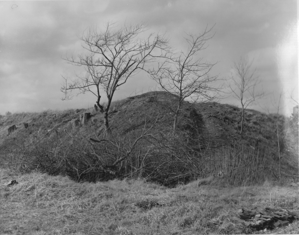
North and east ditch and glacis: At the base of the ramparts the moat is still recognizable, with the glacis descending to the north.
North and East Ditch and Glacis
Parade ground: In the center of the fort. This parade ground is maintained and mowed on a regular basis, and has been used for events and re-enactments.
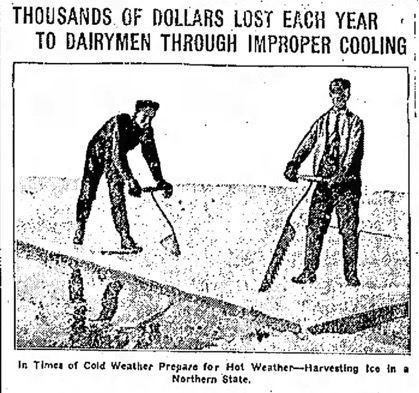
Are you old enough to remember when an “icebox” was used instead of a refrigerator? Ice houses were an important tool in keeping that ice cold to meet refrigeration needs over the summer.
A hundred years ago this week, January 1922, the Newport Mercury reported that ice was being harvested from St. Mary’s “Lake.”
“The severe cold on Monday did not stop the preparations made for harvesting ice at St. Mary’s Lake. Ice about nine inches thick was cut and the ice houses at Oakland Farm have Benn filled. Those at Glen Farm are being filled and the men at Sandy Point Farm were to start on Thursday morning.” (Npt. Mercury 1/7/1922)
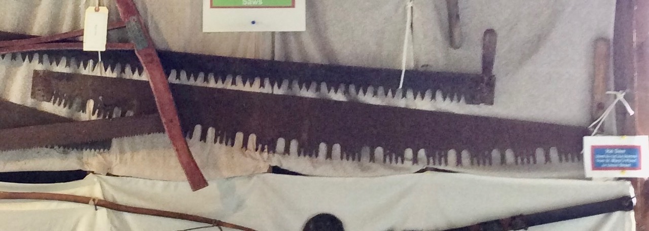
In the collection of the Portsmouth Historical Society is an ice saw with one handle that was actually used to cut ice at St. Mary’s Pond.
Part of that ice was going into a little ice house at Glen Farm. As part of the Glen Farm complex, an ice house was extremely important to farmers like H.A.C. Taylor who owned a dairy. The Newport Mercury in June of 1896 reports that H.A.C. Taylor was having an ice house built by Edward Coggeshall. It measured 24 feet by 16 feet and had a gambrel roof. The house would have very thick insulation to keep the ice cold through the warmer seasons.
Portsmouth is blessed with many historical buildings and it is always good news when efforts are made to preserve these properties. On December 13, 2021, the Portsmouth Town Council voted to use some modest funds to repair and stabilize the Glen Farm Ice House. These funds go a long way to making the ice house a useful town owned building. Portsmouth’s history in many ways revolves around its agricultural heritage and “gentlemen farms” like Glen Farm are part of that history we should celebrate.
From Newport Mercury 1920Glen Ice HouseIce Saw at PHS
A continuation of Sullivan’s letter to the Continental Congress which was published in the Providence Gazette, September 26, 1778.
The stage was set for the Battle of Rhode Island. Sullivan goes on to describe what happened.
August 29, 1778
“The enemy having received intelligence of our movement, came out early in the morning with nearly their whole force, in two columns, advanced in the two roads (East Main and West Main) and attacked our light corps; they made a brave resistance, and were supported for some time by the piquet. I ordered a regiment to support Col. Livingston, another to Col. Laurens, and at the same time sent them orders to retire to the main army in the best order they could; They kept up a retreating fire upon the enemy and retired in excellent order to the main army. The enemy advanced on our left very rear, but were repulsed by General Glover; They then retired to Quaker Hill. The Hessian columns formed a on chain of hills running northward from Quaker Hill. Our army was drawn up, the first line in front of the works, on Butts’s Hill, and the second in rear of the hill and the reserve near a creek, and near half a mile off the hill line. The distance between these is about one mile. The ground between the hills is meadow land, with tree and of wood. The enemy began a cannonade upon us about nine in the morning, which was returned with double force. Skirmishing continued between the advanced parties til near ten o’clock, when the enemy’s two ships of war and __armed vessels having gained our right flank and began a fire, the enemy bent their whole force that way, and endeavored to turn our fight under cover of ship’s fire, and to rake the advanced redoubt on the right: They were twice driven back in great confusion; but a third trial was made with greater numbers and with more resolution which, had it not been for the timely aid sent forward would have succeeded. A sharp conflict of near an hour ensued, in which the cannon from both armies placed on the hills, played briskly in __ part of their own party. The enemy were at length routed, and fled in great confusion to the hill where they first formed, where they had artillery and some works to cover them, leaving their dead and wounded in considerable numbers behind them. It was impossible to be certain of the number of dead on the field, as it could not be approached by either party without being exposed to the cannon of the other army. Our party recovered about twenty of their wounded, and took near sixty prisoners, according to the best accounts I have been able to collect; amongst the prisoners is a Lieutenant of grenadiers. The number of their dead I have not been able to ascertain, but I know them to be very considerable. An officer informs me that in one place he counted sixty of their dead. Col. Campbell came out the next day to gain permission to view the field of action, to search for his nephew, who was killed by his side, whose body he could not get off, as they were closely pursued. The firing of artillery continued through the day, and the _ with intermission six hours. The heat of the action continued near an hour, which must have ended in the ruin of the British army, had not their redoubts on the hill covered them from further pursuit. We were about to attack them in their lines, but the men’s having had no rest the night before, and another to eat either that night or the day of the action, and having been in constant action through most of the day, it was not thought advisable, especially as their position was exceedingly strong, and their numbers fully equal, if not superior to ours.”
Sullivan writes about how well his troops functioned, even though they had little experience.
“Not more than fifteen hundred of my troops had ever been in action before. I should before have taken possession of the hill they occupied, and fortified it, but it is in no defense against an enemy coming from the south part of the island, though exceedingly good against an enemy advancing from the north and towards the town, and had been fortified by the enemy for that purpose.
I have the pleasure to inform Congress, that no troops could possibly show more spirit than these of ours which were engaged. Col. Livingston, and all the officers of the light troops, behaved with remarkable spirit; Colonel Laurens, Fleury, and Major Talbot, with the officers of their corps, behaved with great gallantry. The brigades of the first line, Varnum’s Glover’s Cornell’s and Greene’s behave with great firmness. Major-General Greene, who commanded in attack on the right, did himself the highest honor, by the judgment and bravery exhibited in the action. One brigade only of the second line was brought into action, commanded by Brigadier-General Lovell; he, and his brigade of militia, behaved with great resolution. Col. Crane and the officers of the artillery deserve the highest praise.”
Sullivan writes about the casualties:
“I enclose Congress a return of the killed, wounded and missing on our side, and beg leave to assure them, that, from my own observation, the enemy’s loss must be much greater. Our army retired to camp after the action; the enemy employed themselves in fortifying their camp at night. “
Sullivan justifies the retreat: Lord Howe and his fleet were approaching.
In the morning of the 30th I received a letter from his Excellency General Washington, giving me notice that Lord Howe had again sailed with the fleet, and receiving intelligence at the same time that a fleet was off Block Island and also a letter from Boston, information me that the Count D’Estaing could not come round so soon as I expected, a council was called, and as we could have no prospect of operating against Newport with success, without the attendance of a fleet, it was unanimously agreed to quit the island until the return of the French squadron.
The retreat plan is shared with Congress
To make a retreat in the face of an enemy, equal, if not superior in number, and cross a river without loss, I knew was an arduous task, and seldom accomplished, if attempted. As our sentries were within 200 yards of other, I knew it would require the greatest care and attention. To cover my design from the enemy, I ordered a number of tents to be brought forward and pitched in sight of the enemy, and almost the whole army employed themselves in fortifying the camp. The heavy baggage and stores were falling back and crossing through the day; at dark, the tents were struck, the light baggage and troops passed dawn, and before twelve o’clock the main army had crossed with the stores and baggage. The Marquis de la Fayette arrived about 11 in the evening from Boston, where he had been by request of the general officers, to solicit the speedy return of the fleet. He was sensibly mortified that he was out of action; and that he might not be out of the way in case of action, he had rode from hence to Boston in seven hours , and returned in six and a half, the distance near seventy miles — he returned time enough to bring off the pickets, and other parties, which converted the retreat of the army, which he di in excellent order; not a man was left behind, nor the smallest article left. I hope my conduct through this expedition may merit the approbation of Congress. Major Morris, on of my aids will have the honor of delivering this to your Excellency; I must beg leave to recommend him to Congress as an officer who is in the last, as well as several other actions, has behaved with great spirit and good conduct, and doubt not Congress will take such notice of him, as his long service and spirited conduct deserves. I have the honor to be, dear Sir, with must___ Your very humble servant – John Sullivan.
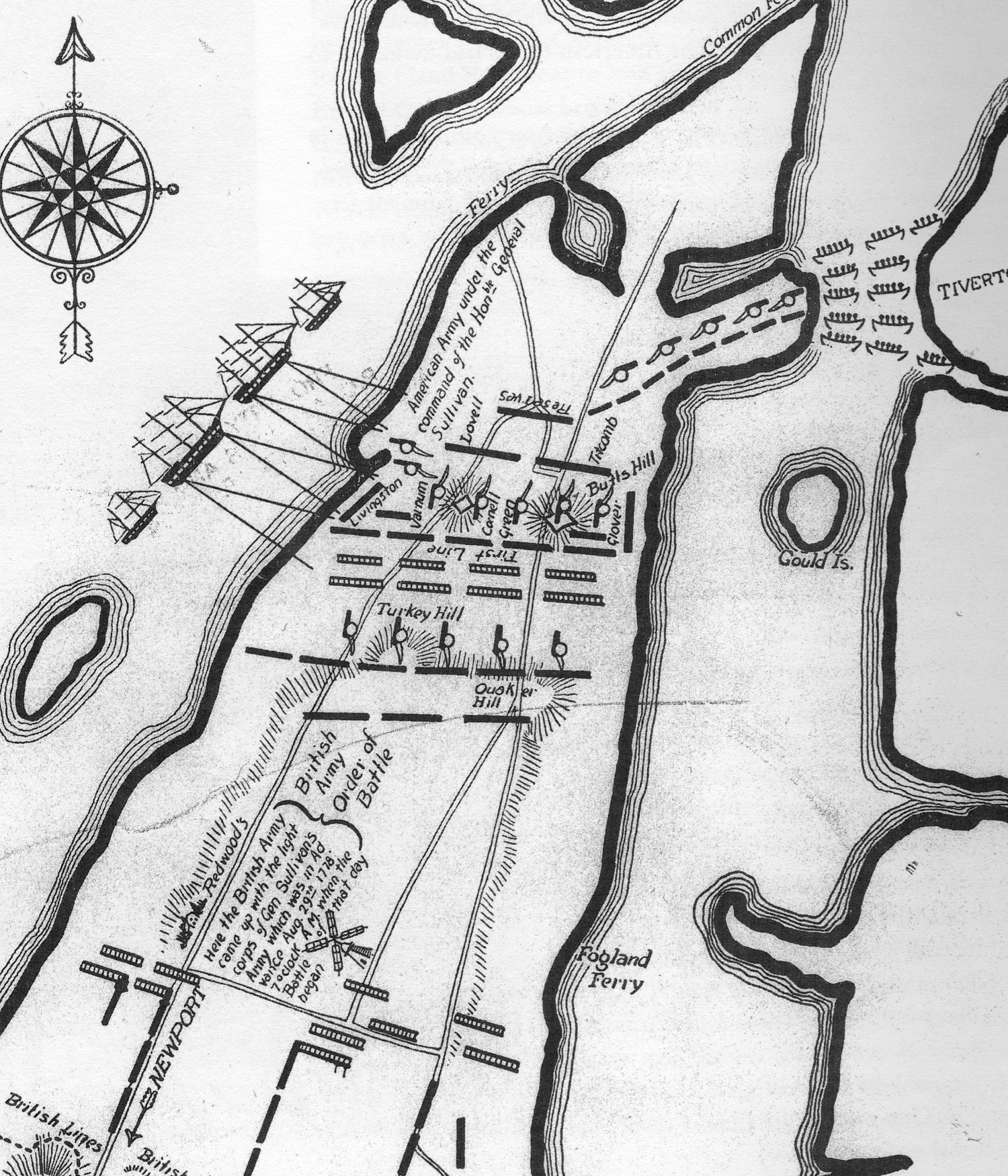
Plan of the Battle of Rhode Island from a Commonwealth Land Title Insurance Company map, 1926
Did you know that we have an important battlefield in Portsmouth? Most Rhode Islanders aren’t aware that within Portsmouth is an area of 365 acres that has been designated an historic district on the National Register of Historical Places. We can view this battlefield from Heritage Park off of Hedley Street and from a site on the top of Lehigh Hill that has signage to help you understand the action of the battle. The monument to the Black Regiment between West Main Road and Route 24 and Butts Hill Fort are part of this battlefield as well. There are new efforts to preserve and restore Butts Hill Fort which would give us the view of the battlefield from the position of Patriot headquarters.
Battle of Rhode Island Historic Landmark District.
What is the National Register and what special significance is this area of Portsmouth?
According to their website: “The National Register of Historic Places is the official list of the Nation’s historic places worthy of preservation. Authorized by the National Historic Preservation Act of 1966, the National Park Service’s National Register of Historic Places is part of a national program to coordinate and support public and private efforts to identify, evaluate, and protect America’s historic and archeological resources.”
What is special about this 365 acres of our town? This parcel of land is an important Revolutionary War battlefield. The Battle of Rhode Island was fought in Portsmouth in a valley between three hills. Lehigh Hill is to the North and Turkey and Almy Hills are to the south. This battlefield area along with the 34 acres of Butts Hill Fort are included in this historic district. The outline of the battlefield is approximately:
Western boundary: Parallel to West Main Road. Southern boundary: Cory Lane, West Main Road and a short stretch of Hedley Street. Eastern boundary runs to the east of Turkey Hill and then northward around Barker’s Brook. The boundary crosses Freeborn and Dexter to the southern rise of Lehigh Hill. Butts Hill Fort is to the northeast of the battlefield and is included in the battlefield.
Historians who prepared the application for this designation as an historic district cited a number of reasons why the Battle of Rhode Island was of significance and why the battlefield should be preserved.
The Battle of RI (BRI) was the last major battle fought in the North during the Revolution.
This was the only major battle fought in Rhode Island, so it is important to Rhode Island military history.
The battle was the only occasion in which the Black Regiment served as a segregated unit. They served admirably in repulsing three successive enemy assaults. Due to losses of men in combat and with the repeal of the law allowing blacks to enlist, by 1780 this unit was combined with other units under Christopher Greene.
The battle shows the growing professionalism of the American army.
Although the French were not able to stay and participate in the battle, the overall plan was the first joint effort of the French and American alliance.
The British realized their position in Newport was vulnerable. The Indecisive conclusion of the battle was indirectly responsible for the British evacuation of Newport in October of 1779.
What action occurred on this battlefield during the Battle of Rhode Island? The following descriptions are culled from Christian McBurney’s book, The Rhode Island Campaign by Battle of Rhode Island Committee member Seth Chiaro.
Turkey Hill Engagement: Hessian troops under Captain Von Malburg pursued American Col. Laurens Regiment to Turkey Hill. Laurens men took up a strong defensive position on top of Turkey Hill. Col. Lauren sent a request for reinforcement to General Sullivan. Sullivan responded with orders to ‘fall back to the main line’. General Sullivan sent Webb’s Connecticut Regiment to support Laurens retreat. Ameican and Hessian units engaged on Turkey Hill before the Americans fell back. Laurens Regiments fell back to General Nathanael Green’s position to the right of Butts Hill. By 8:30 am the Hessians had secured Turkey Hill.
Lehigh Hill Engagement (Durfee’s Hill): General Nathanael Greene held the right flank of the American Army, along the right-wing stood a small Artillery Redoubt. This was a vital position for both sides. The 1st RI Regiment (Black Regiment) was under the direct command of Major Samiel Ward who was commanded by Col. Christopher Greene, a distant cousin of Nathanael Greene. Captain Malsburg was ordered to attack the hardened position. The first attack failed. The 1st RI Regiment held its ground. The Hessians tried multiple times to take the position. The Hessians tried to flank the position, this also failed. On the third attempt, the 2nd RI Regiment supported the 1st RI Regiment. As the 2nd RI Reg. approached the redoubt the Hessians were attempting to climb the walls. All together Greene had about 1,600 soldiers fighting on the Lehigh Hill. Units included 1st RI Regiment, 2nd RI Regiment, Livingston’s 1st Canadian, Sherburne’s, and Webbs Regiments. More than 800 Continentals including Laurens advance guard and Jacksons’ Detachment. The American line veered SW at a 45-degree angle from Butts Hill to Durfee’s Hill making the American fire even more effective. Col. Henry Jackson’s men fixed bayonets and charged into the Hessian Line, turning the tide of the battle. The Battle was over at 4 pm. The Hessians retreated to Turkey Hill. Both sides exchanged cannon fire throughout the night. Cannon fire was also exchanged between Turkey Hill and the Butts Hill Fort.
After the Battle of Rhode Island, John Sullivan had to explain his retreat from Aquidneck Island. We have a record of that explanation in a letter published in the Providence Gazette on September 26, 1778. “Letter from the Hon. Major General Sullivan to the President of Congress dated headquarters Tiverton, August 31, 1778″. I was able to find that article and transcribe it. This is quite a lengthy letter, so In the next few blogs I will take you through Sullivan’s explanations in stages. In reading through this letter, we need to remember that Sullivan had been part of retreats before and the Congress had questioned his actions. I am not a military historian and I am only now beginning to study the Battle of Rhode Island, but this is a primary source to be respected as a first hand account of the man in charge of the American troops in the battle.
For some background I searched for some basic information about John Sullivan. He was born in New Hampshire in 1740, the son of Irish immigrants. His original training was as a lawyer. In 1772 New Hampshire’s Royal governor appointed him as major in the New Hampshire militia. As the break with Britain was unfolding, he began to favor the rebel cause. Sullivan was sent as a delegate to the First Continental Congress in 1774. In 1775 Sullivan was sent to the Second Continental Congress. Congress appointed George Washington Commander in Chief and John Sullivan as brigadier general. Sullivan joined the army at the siege of Boston. Later he took command of a force in Quebec in a failed invasion. Sullivan had to withdraw the survivors. He was captured in defeat at the Battle of Long Island. British General Howe released him on parole to deliver a message to Congress. He was later released in a prisoner exchange for captured British general Prescott. He had some success in battle but had continued difficulties as well. In Early 1778 he was transferred to the post of Rhode Island where he led the continental troops and militia. John Sullivan fought bravely, but his command decisions were questioned on a number of occasions. He had to defend himself, but he was often judged not at fault. Sullivan needs to explain his decisions.
The first part of the letter deals with the prelude of the battle. The French fleet under Count De’Estaing had gone to Boston to make repairs and Sullivan expressed belief that they would come back soon. He decided to carry on with the planned invasion of Aquidneck Island.
“I thought it best to carry on my approaches with as much vigor as possible against Newport, that as time might be lost in making the attack upon the return of the fleet, or any part of it, to cooperate with us. I had sent expresses to the Count to hasten his return which I had no doubt would at least bring part of his fleet to us in a few days.”
Initially he had good success and the enemy abandoned positions. “…on the 27th we found they had removed their cannons on all the outworks except one.” He details the British positions at Newport and described them as two basic lines. He expresses regrets that he had not stormed some of these defenses when the cannons had been withdrawn, but he began to lose manpower. “
He writes he found: ” ..to my great surprise, that the volunteers which completed the great part of my army, had returned [left for home], and reduced my numbers to little more than that of the enemy; between two and three thousand returned in the course of twenty-four hours, and others were______ going off, upon a supposition that nothing could be done before the return of the French fleet.”
Sullivan’s troops were a combination of Continental soldiers and militia. Many militia units came from nearby Massachusetts and in discouragement that the mission could not be accomplished without the French fleet, many units headed home. General Sullivan was in a difficult position.
“Under these circumstances, and the apprehension of the arrival of an English fleet with a reinforcement to relieve the garrison, I sent away all the heavy articles that could be spared from the army to the main; also a large party was detached to get the works in repair on the north end of the island to throw up some additional ones, and put in good repair the batteries at Tiverton and Bristol, to receive a retreat in case of necessity.”
General Sullivan began to prepare for a retreat. He knew that enemy reinforcements were coming and his best course was to retreat. This was not a hasty retreat. He ordered increased defenses in the North (especially Butts Hill Fort and forts guarding the Bristol Ferry and the ferry to Tiverton). He wanted to get all his weaponry out so it would not fall into enemy hands to use against them another day. His letter makes clear that this was an “unanimous” decision to first retreat to Portsmouth and hope that the French would return.
“On the 28th a council was called, in which it was unanimously decided to remove to the north end of the island, fortify our camp, ______ (secure?) our communication with the main, and hold our ground on the island til we could know whether the French fleet would _____ return to our alliance. On the evening of the 28th we moved with our stores and baggage, which had not been previously sent forward, and about two in the morning encamped on Butts’s Hill, with our right extending to the west road, and left to the east road; the flanking and covering parties ____further towards the west road on the right and left.”
Sullivan details the positions of his forces on the evening of August 28, 1778.
“One regiment was posted in a redoubt advanced to the right of the __ line. Colonel Henry B. Livingston with a light corp, consisting of Colonel Jackson’s detachment, and a detachment from the army was stationed in the east road: Another light corp, under command of Colonel Laurens, Col. Fleury, and Major Talbot, was posted on the west road. These corps were posted near three miles in front; in the rear of these was the picquet of the army, commanded by Col. Wade.”
The stage is set for battle.
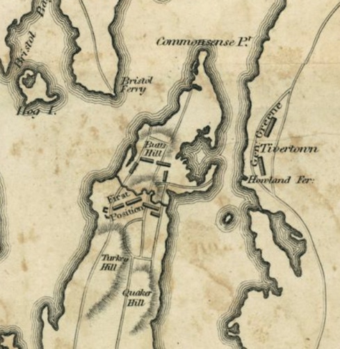
Map of the Siege of Newport during the Revolutionary War. Sabin Lewis, RI 1778. Rhode Island Historical Society Collections RHiX171926
This is a work in progress as I uncover more dates of importance in the land history of the Butts Hill – (Windmill Hill – Briggs Hill) area. Working with the early dates is difficult.
Until 1638: The land on Aquidneck Island was a summer hunting ground for Wampanoags and later the Narragansetts.
1638 – Portsmouth town land.
1665 – Land owned by Caleb Briggs.
1666 – Windmill erected on Briggs Hill or Windmill Hill (from Preservation book).
1668 – Windmill completed by William Earle and William Cory.
1682 (Feb 24, 1682) – William Cory (carpenter and miller) in his will gave windmill to his wife Mary. Mary traded land back to the town.
1688 William Earle (Wm Cory’s brother in law) built windmill on Briggs Hill (I doubt this date unless this is a second windmill on the spot).
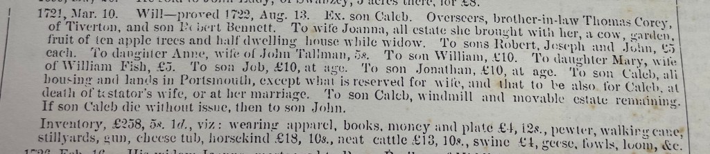
1721 – Caleb Bennett inherits windmill from father Robert Bennett. Robert had married Anne Cory – daughter of William and Mary Earle.
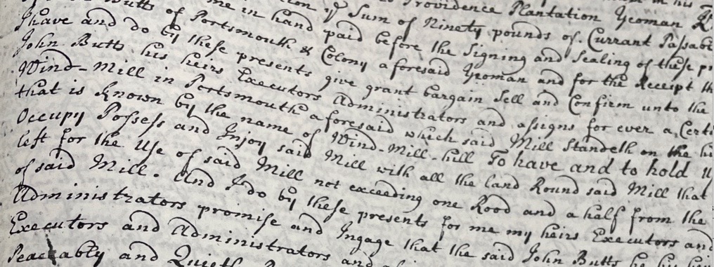
1725 (January) – John Butts bought from Caleb Bennett the windmill and about one rod of land (maybe a quarter of an acre) on Windmill Hill.
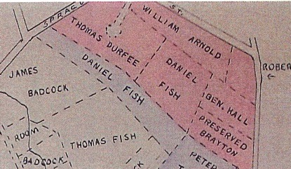
Before 1729 : Town gave a land grant to Thomas Durfee. West land-grant map shows windmill already on site. My suspicion is that town had held the larger parcels of land until this time. Windmill area small piece of that whole.
1729 (February): Town records show “a parcel called the Wind Mill Hill land” given to son Gideon Durfee. I suspect that there were several parcels of land on Windmill Hill. The West land-grant maps show that.
1776 – Americans built small battery at Butts Hill.
1776 to 1779 – British occupation of Island and fort.
1778 – July 29 to August 15 – Siege of Newport: British bring troops down to Newport. August 11: American troops at Butts Hill.
1778 – August 29-30 Battle of Rhode Island. Gen. Sullivan uses Butts Hill Fort as headquarters.
1778 – September 1, British return to Ft. Butts (known as Windmill Hill to them).
1779 – December – Butts Hill Fort returned to American control.
1780-1781 Camp Butts Hill housed French and American troops.
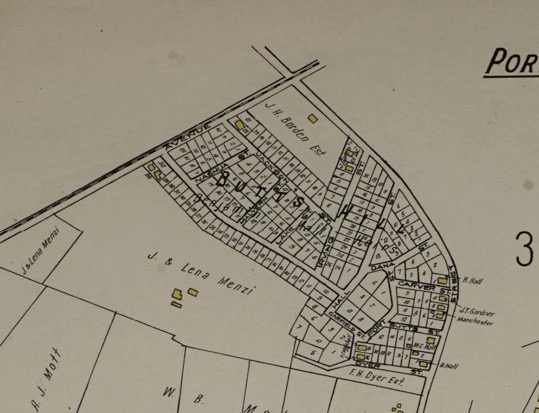
1782 Butts Hill Fort was abandoned by the end of the war (1782). 1900 House lots for sale – Benjamin Hall Jr. 1907 – Dyer family farm. Fort and surrounding platted for 200 house lots. 1908 – Benjamin Hall selling house lots
1920s -1930s. – Roderick Terry conveyed to Newport Historical Society, pieces of the land in 1923, 1924, and 1932. 1968 state transfers land to Town of Portsmouth.
House lots proposed 1910West land-grant map.Mary Cory inheritsCaleb Bennet inherits
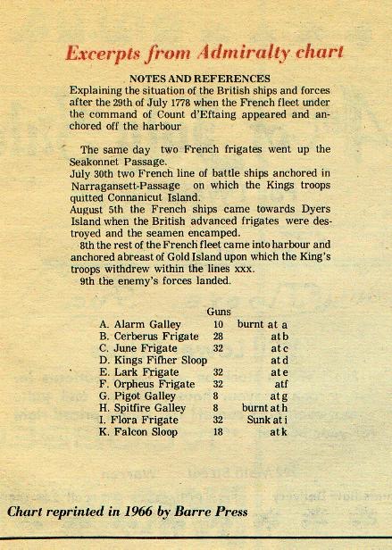
Recorded in the London Gazette is a letter from Major General Pigot to General Clinton – dated August 31st, 1778. From this letter we learn of the preparations the British made with the threat of French ships approaching. With the appearance of the French, Pigot began to gather provisions, ammunitions and stores of goods in order to prepare a fortified camp.
With the French in the Sakonnet, Pigot ordered the Kingfisher and two Galleys (Alarm and Spitfire) to be set on fire; and afterwards … the four advanced Frigates (Juno, Orpheus, Cerberus, Lark). These ships were destroyed to keep them from being captured.
According to the annotations by John Hattendorf:
Kingfisher was a sloop. She was deliberately set on fire, broke from anchorage and blew up off High Hill Point in Tiverton
Alarm was a galley. She was set on fire and exploded south of McCorrie Point.
Spitfire was a galley. She also was set on fire off High Hill Point in Tiverton.
Juno was sunk in Coddington Cove.
Orpheus was sunk off Melville.
Cerberus was sunk about 400 feet off Carr Point.
Lark was sunk on the south side of Arnold’s Point in Portsmouth.
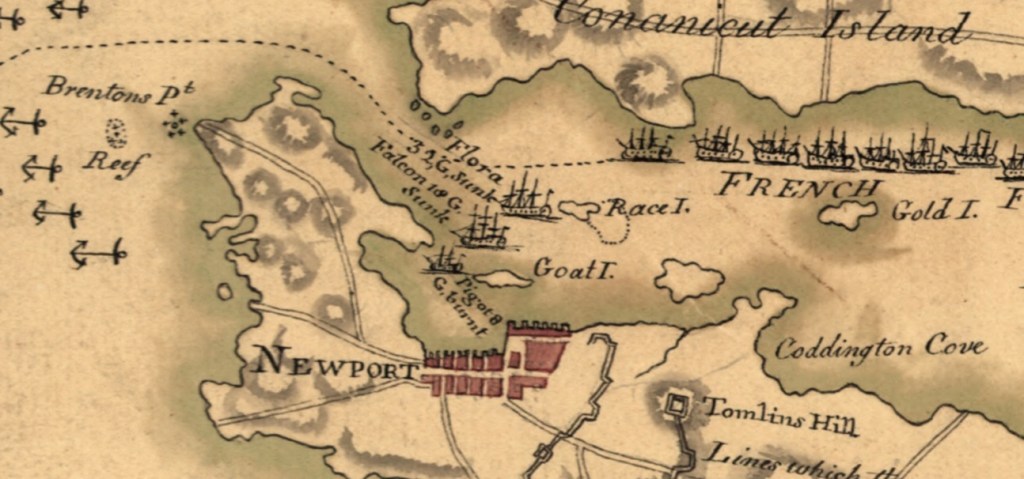
A few years ago I had come across a newspaper clipping dealing with these scuttled British ships. I’m not sure where the clippings came from, but Barre Press 1966 was sited in the article. Note that Flora, Pigot and Falcon are also listed as burned or sunk. Red circles show the locations of the downed ships.
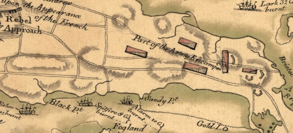
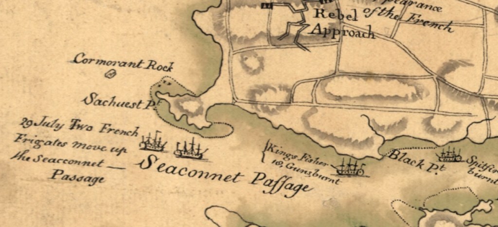
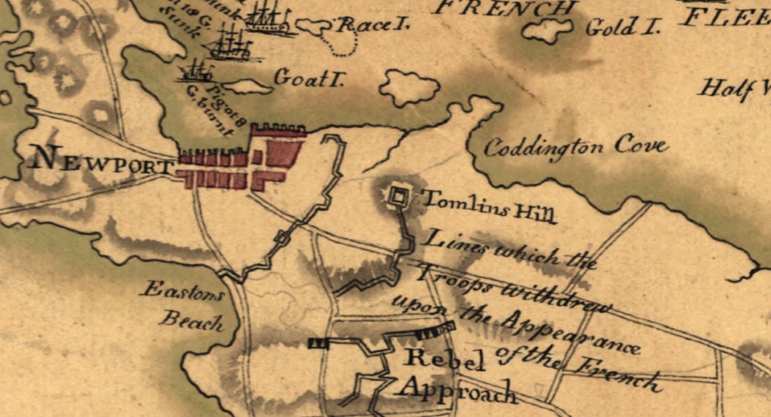
The ship locations also appear on an early map 1778- Attacks upon Rhode Island that is in the collection of the Library of Congress.
1778- Attacks upon Rhode Island – map in collection of the Library of Congress
Resources:
John Hattendorf – The Battle of Rhode Island in 1778: the Official British View as Reported in the London Gazette.2021 Stone Tower Press, Middletown, Rhode Island
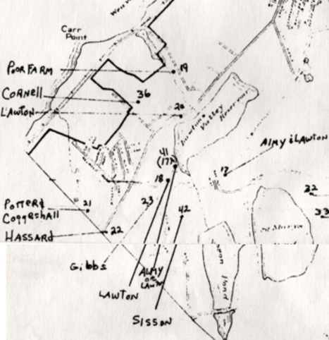
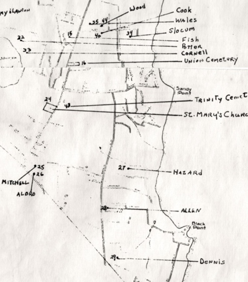
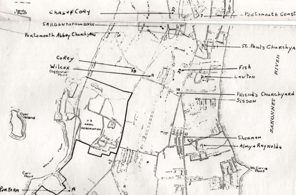
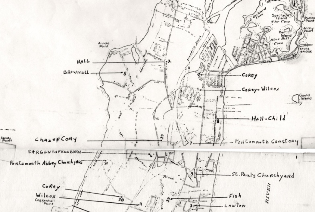
News of a new family cemetery find near the Water Works by Stephen Luce brought to mind a working map from the 1970s that is in the collection of the Portsmouth Historical Society. I believe it was the part of a notebook kept by Herbert Hall III when he and others were surveying the historical cemeteries in town. When families come to town to research their ancestors, this is one map I try to share.
A new book with material presented by John Hattendorf gives us a glimpse of the British view of the battle. ( “The Battle of Rhode Island in 1778. The Official British View as Reported in The London Gazette. Middletown, RI, Stone Town Press, 2021). This slim volume offers an annotated transcript of the battle as it appeared in the British government’s official publication. Hattendorf’s explanations and copious notes are valuable as we research what happened during the battle. I will be examining the reports gradually in this blog. I appreciated Hattendorf’s introductions, but it is the primary sources – such as the letters printed in The London Gazette – that often give us insights.
A segment from a letter from Sir Henry Clinton dated New York, September 15, 1778:
“In the State Things were, when Lord Howe sailed for Rhode Island; and it was my intention to proceed up the Sound, with the Troops above mentioned, (4,000), that they might be within his Lordship’s Reach, in case we should see an Opportunity for landing them to act with Advantage; but on the 27th of last Month (August), at the Instant they were embarked, I received a Letter from Lord Howe, inclosing one from Major-General Pigot, by which I was informed, that the French Fleet had quitted Rhode Island; but that the Rebels were still in great Force.
I thought it advisable to sail immediately for the Relief of that Place, but contrary Winds detained us till the 31st; and, on our Arrival, we found that the Enemy had evacuated the Island……..I was not without Hopes, that I should have been able to effect a Landing, in such Manner as to have made the Retreat of the Rebels from Rhode Island very precarious; or that an Opening would have offered for attacking Providence with Advantage: Being thwarted in both these Views by the Retreat of the Rebels, as the Wind was fair I proceeded towards New London……”
This letter from Clinton helps me to understand how critical and precarious the “Retreat of the Rebels” was. Clinton was bringing 4,000 troops to Newport, but he had missed the French fleet. After damage in a storm, d’Estaing and the French were heading to Boston for repairs. He was alarmed that “the Rebels were still in great Force.” He proceeded on to Newport, and his hope was to 1) have the Retreat of the Rebels “very precarious” and 2) that they could attack Providence. Winds detained him.
The Americans were indeed in a precarious situation. The winds of a storm foiled the plans of the Americans and French, but the “wind coming unfavorable” made Clinton’s troops unable to foil Sullivan’s retreat.
Map:
Attacks upon Rhode Island, Augt. 1778. Created / Published [1778] – Collection of Library of Congress.