The occupation had taken its toll and right after the War for Independence, Portsmouth farmers needed to focus on their own interests. To make good their losses, Portsmouth families petitioned the state for compensation for the damages suffered during the War. Among the documents in the collection of the Portsmouth Historical Society is such an inventory of losses dated around 1780. Robert Binney (Benney) and Elizabeth Heffernan were “in laws” who shared a home and a 26-acre farm just north of the Quaker Meeting House. The household inventory that they prepared can give an idea of what Portsmouth residents lost in the War. Among the items destroyed were five acres of orchards, a mare and 5 hogs. They lost their corn crib, four acres of corn, 12 loads of hay, twelve goats, two cows and one calf, a jackass and a ox cart among other household items.
To read a transcription of the whole inventory of household losses, click the manifest link.
The Portsmouth Historical Society has a rich collection of documents dating from the 1600s and 1700s, but we have very few documents from the Revolutionary War Era. War came to Portsmouth on December 8, 1776 when the British forces landed at Weaver Cove and they occupied the town until their forces left on October 25, 1779. Among the few documents that we do have, the name “David Gifford” is prominent. Gifford was a local ferry man and tavern owner. He took a leading role in the pre-war militia activity, he served as a Deputy from Portsmouth during the war, and state records show that he participated in military and naval activities during the war.
From its start Portsmouth traditionally had a militia. As war threatened in 1774, the Rhode Island General Assembly ordered monthly drills of all militia companies with full preparations for war. Since 1772, David Gifford had already been transporting town records and other items to and from Providence with his ferry boat. As the threat of war increased, the town records show that on August 29, 1775 the town voted “that David Gifford Draw the sum of Eighteen shillings out of this Town Treasury . . . for bringing . . . this Town’s Proportion of Powder & Balls from Providence.”
In the opening stages of war in 1775, Portsmouth raised a company of around sixty men to march to the support of Boston with a regiment raised in Newport County. A group of militia remained on guard at the town while the others were gone. Portsmouth created the fourteen-member volunteer “Artillery Company,” and provided it with 115 pounds of powder, 184 pounds of lead and 739 flints (spark making rocks). These local minutemen were to “March out to Action” when needed, and when they became part of the 1st Rhode Island Regiment in 1776, the Colony of Rhode Island provided cannons on carriages. In August of 1775 its leaders were Captain John Earl, Lieutenant James Peckham, and Ensign Cook Wilcox. Later artillery company leaders were David Gifford and Burrington Anthony. By the end of the Revolution almost all Portsmouth men from ages sixteen to sixty had served in the military.
The assembly in Providence called for additional troops and David Gifford was appointed to dole out the bounty of forty shillings to be paid to those who enlisted. Portsmouth was receptive to the calls for additional troops. Town records show that on September 17, 1776 the freemen voted that “seventeen able bodyed men be Enlisted into the servis of this State being the Town’s proportion, and that forty shillings Lawful Money be paid for every such person so Inlisted if they provide themselves with Arms & Accoutrements and that Capt. David Gifford provide the Money for said use & that he be Repayed out of this Town’s Treasury as soon as possible.”
By February 1776 the town meeting ordered their town council to draw up a list of people in town who could not provide their own firearms. The freemen voted 240 dollars or 75 pounds lawful money to purchase firearms. A committee of four men was assigned to get the money and purchase twenty small arms. David Gifford, one of the committee was selected to receive the weapons.
When the British and Hessians arrived in December of 1776, there were citizens who fled to Tiverton or Bristol. It is likely that David Gifford and his ferry boat left the island. In December of 1776 Rhode Island Records state “It is voted and resolved that Capt. David Gifford be permitted to proceed with a flag of truce to Rhode Island, under the direction of His Honor the Governor, upon his procuring three prisoners of war to exchange for three soldiers lately belonging to his company, and now detained as prisoners on said island.” It would be interesting to know which three of his Portsmouth militia company were part of the exchange.
By August of 1777 he was a member of the General Assembly and he was appointed a Lieutenant in Major Munroe’s Company. Being a ferry man, he took part in naval operations as well. The April 6, 1778 journal entry of Captain Joseph Crandall of the Rhode Island Navy Schooner-rigged Armed Galley Spitfire notes that Gifford and his ferry boat took part in a raid to Bristol Ferry on Aquidneck Island where they set fire and destroyed a British sloop. This daring raid was conducted while the Americans were being fired on from the British fortifications at Bristol Ferry.
We don’t have records of Gifford being in military service during the Battle of Rhode Island or during the remainder of the war. In 1780 and 1781 he was appointed Deputy from Portsmouth. He continued to receive recruits and handle bounties for the enlisted.
David Gifford led a full life. He was active in the Portsmouth community as a tavern keeper and ferry man at Bristol Ferry. He was a militia leader who was essential in recruiting soldiers and getting the militia armed and ready for war. He was trusted with a prisoner exchange. He used his skills as a ferry man on a daring raid to burn an enemy ship. He served Portsmouth as a Deputy. David Gifford died May 17, 1790 and is buried at St. Paul’s Cemetery. He was only in his forties, but he had lived a full life of service to Portsmouth.
We are fortunate to have eyewitness accounts of the Battle of Rhode Island. One of those accounts is by Lieut.-Colonel Samuel Ward, the son of Rhode Island Governor Samuel Ward. He was born in Westerly on November 17, 1756. He graduated from Brown University in 1771. He was the grandfather of Julia Ward Howe.
Ward received his commission as Captain on May 8th, 1775. Ward was promoted to major of the 1st Rhode Island Regiment on January 12, 1777 and became a lieutenant colonel on 5 May 1779 (with date of rank retroactive to May 26, 1778). When the First Regiment arrived on Aquidneck Island, there were changes in leadership. Major Samuel Ward was given command of the First Rhode Island Regiment. The regiment was assigned to guard the abandoned British redoubt that was part of the American line. This location was to the southwest of Butt’s Hill. Ward and the Black Regiment are credited with driving back three waves of Hessian troops.
Ward’s published diary is more of an account of his military career with just a few quotations with his actual words. Fortunately the description of the Battle of Rhode Island is among the quotations.
The August 30, 1778 diary entry provides an eyewitness account: “The army retreated the evening of the 28th. Early yesterday morning, the enemy moved out after us, expecting that we were leaving the island, and took possession of the Heights in our front. They sent out parties in their front, and we made detachments to drive them back again. After a skirmish of three or four hours, with various success, in which each party gave way three or four times, and were reinforced, we drove them quite back to the ground they first took in the morning, and have continued there ever since. Two ships and a couple of small vessels beat up opposite our lines, and fired several shots, but being pretty briskly fired upon from our heavy pieces, they fell down, and now lay opposite the enemy’s lines. Our loss was not very great, it has not been ascertained yet; and I can hardly make a tolerable conjecture. Several officers fell, and several are badly wounded. I am so happy to have only one captain slightly wounded in the hand. I believe that a couple of the blacks were killed and four or five wounded, but none badly. Previous to this, I should have told you our picquets and light corps engaged their advance, and found them with bravery.”
We can make some comparisons between the diary accounts of Ward and Angell. Each was with a different Regiment – Ward RI First and Angell RI Second – so they had different skirmishes to fight.
Looking at the Movements of the Rebel and British forces:
Ward reports that the army began to retreat on the evening of August 28th. Angell reports that his troops struck their tents and marched north on August 29th.
Both Ward and Angell show fighting back and forth between the Rebels and the British. Ward reports that one such skirmish lasted three or four hours “in which each party gave way three or four times.”
Both Angell and Ward tell us that the British ships were firing on the Rebel forces, but Americans fired on them and the vessels retreated.
Looking at casualties:
Ward comments “our loss was not very great” and Angell seems to report that the British had considerable losses but there were only three or four of the Rebels killed.
Looking at the retreat:
Angell tells us that the Americans retreated because of Washington’s warning about British ships heading in.
Angell also tells us more about the retreat via Howland’s Ferry. The soldiers had little sleep and little to eat. They had to “lie in their lines” that night and the crossing happened in the early hours of the morning. After encamping near the ferry they went to an area between Bristol and Warren.
Sources:
A Memoir of Lieut – Colonel Samuel Ward, First Rhode Island Regiment, Army of the American Revolution; John Ward, New York, 1875. (available on Kindle)
Laura E. Richards, Maud Howe, Florence Howe Hall, Julia Ward Howe, 1819-1910, in two volumes, with portraits and other illustrations: volume 1
Geake, Robert. From Slaves to Soliders. Yardley, Pennsylvania, Westholme Publishing, 2016.
Primary sources are what I look for when I am researching topics. Primary sources are first hand accounts. Some examples are documents, letters, maps created at the time, newspaper accounts, photographs and diaries written at the time an event took place. We are fortunate to have some diaries which record what happened during the Battle of Rhode Island. This blog will focus on entries from the diary of Col. Israel Angell. With any primary source, a researcher should answer some basic questions to set the source in context.
Who wrote this diary?
Who might have been the intended reader?
Where and when was it written?
What does it tell me about the subject I am researching.
Who wrote this diary?What do we know about him? Israel Angell was a descendant of Thomas Angell, who came to Providence with Roger Williams. He was born in North Providence on August 24, 1740. Angell joined the rebel cause from the beginning. When an army was formed by the General Assembly of Rhode Island in 1775, he was commissioned as a Major. With the formation of the Second Rhode Island Regiment, Israel Angell was elected Lieutenant-Colonel. The regiment went to join the army under Washington. Command of the regiment was given to Angell, on Jan. 13, 1777 when the Colonel in charge died. His regiment was detached from the main army and sent to Rhode Island to fight with General Sullivan in the operations against the enemy on Aquidneck Island.
Who might have been the intended reader? A diary is a very personal document and may just have been a way for Angell to keep track of what he experienced. As an officer, it may also be a record that might be consulted if he was questioned later.
Where and when was it written? These three entries are in late August of 1778 at the time of what call the Battle of Rhode Island. It reflects what was going on in Portsmouth during the battle.
What does it tell me about the Battle of Rhode Island? As you read through the diary entries, do you find information that answers some of our questions – What were the movements of the Americans and of the British? What were some of the Portsmouth locations mentioned? What were the American casualties? What happened to Angell during the battle and afterwards? Why did the Americans retreat? How did the retreat proceed?
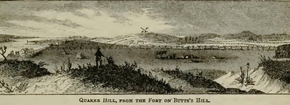
August 29th, 1778. A Clear morning and Very Cool the ( ) Recd orders last evening to Strike their tents and march to the north end of the island; the advanced piquet was to come off at 12 oclock the enemy finding that we had left our ground pursued with all possible speed Come up with our piquet about sunrise and a smart firing begun, the piquet repulsed the Brittish troops 2 or 3 times but was finily obliged to retreat as the Enemy brought a number of field pieces against them the Enemy was soon check’t by our Cannon in coming up to our main body and they formed on Quaker Hill and we took possession of Buttses Hill the left wing of the brittish army was Compossed of the hessians who Attackt our right wing and a Sevear engagement Ensued in which the hessians was put to flight and beat of the ground with a Considerable loss our loss was not very great but I cannot assertain the number. I was ordered with my Regt to a Redoubt on a Small hill which the Enemy was a trying for and it was with Difficulty that we got there before the Enemy. I had 3 or 4 men kill’d and wounded to day at night I was ordered with my Reg to lie on the lines I had not Slept then in two nights more than two or three hours the Regt had eat nothing during the whole Day this was our sittuation to goe on guard, but we marched off Chearfully and took our post.
August 30th. A Cloudy morning and the wind very high it rained a Considerable in the night the Enemy Remained on their Ground this morning two English friggats Came up yesterday to prevent our retreat but could do but little they Still Remained here. I was Relieved this morning and got Some provisions and being much worn out for the want of sleep went to a hous and took a good knap there was a Cannonade kept up to day and Some small arms from the Sentries at night we Recd orders to Retreat off the Island which we did without the loss of anything, this Retreat was in Consequence of an Express from Genl Washington informing Gen Sullivan that the Brittish Ships of war and transports had sailed from New York Some days before.
August 31st, 1778. Our retreat off the Island was completed by three o’clock this morning it is Supos’d that the Enemy attempted a Retreat last Evening but after finding that we Had Retreated they Returned to their ground as it was late in the morning before they took possession of the forts we left …………..After we had Crost at howlands ferry we Encampt about a mile from Sd. ferry where we tarried this day at Night Rec’d orders to Strike our tents next morning and Embark on board our Boats and Land near Warren as Genl Varnums Brigade was to be stationed Between warren and Bristol. Genl Cornells at Rowlands ferry Genl Glovers at Providence Col. Comdt Green at warwick and Greenwich.
I will go through what information I gained from the diary in another blog as I compare this diary account with that of Samuel Ward from the First Rhode Island Regiment.
Sources:
Angell, Israel. Diary of Colonel Israel Angell Commanding the Second Rhode Island Continental Regiment during the American Revolution 1778-1781. Edited by Edward Field. Providence; Preston and Rounds, 1899.
As we look to restoring Butts Hill Fort, one question that comes up is how the fort developed in the first place. The Diary of Frederick Mackenzie * in combination with the Revolutionary Era maps of the area give us an idea of how Butts Hill Fort (Windmill Hill Fort) developed over time. Military historians will have a better handle on construction methods, but the diary, maps and blueprints can help us to understand what we see at Butts Hill today.
December 8, 1776: as Mackenzie was arriving on the island as part of the British forces, he wrote: “The Rebels abandoned a well situated fort at the N. End of the Island yesterday, without attempting to defend it. It in some measure commands the passage to Bristol by the ferry.” My guess is that this is a reference to the Butts Hill (or Windmill Hill location as the British called it). The location does overlook the Bristol Ferry landing.
Dec. 30, 1776: The redoubt constructed by the Rebels above Bristol Ferry, and abandoned by them, is ordered to be repaired and a guard house to be erected therein for the accommodation of the advanced post. It is a much better situation for the advanced guard than that they are now in, and the troops on duty will not be liable to accidents from the wanton firing of the Rebels on the opposite side. This again I believe to be a reference to the Butts Hill Fort in the area “above Bristol Ferry.” The Rebels had fortifications across in Bristol and they would often direct fire at the troops stationed by the Aquidneck side of the Bristol Ferry crossing. The order here is to repair the redoubt and build a guard house.
Sept 12, 1777: As the works intended to be made for the defense of the North Part of the Island, require a good many workmen to complete them, and the duty of the Soldiers is rather severe, General Pigot sent a summons this day to the Inhabitants of the township of Portsmouth to assemble on the 15th instant at Windmill Hill in order to assist in carrying them on. They are required to work three days in the week.
Sept 15, 1777: In consequence of the General’s summons to the Inhabitants of the township of Portsmouth, to assemble in order to be employed to work on the Redouts, 17 only appeared this morning at the place appointed. The Majority of the Inhabitants being Quakers, they informed the General that it was contrary to their principles to assist, in any manner in matters of War, and that therefor they could not appear. They even refuse to be employed in constructing Barracks for the accommodations of the troops.
Sept. 17, 1777: We are at present very busy in fortifying different posts on the Island; and there are already more works planned and traced out, than can possibly be finished by the end of December. Those intended are a redoubt for 30 men and 2 cannon opposite Howland’s bridge. A fortified Barrick on Windmill hill for 200 men. A Redoubt on Barrington’s Hill for 80 men and 2 cannon. A redoubt at Fogland Ferry for the like numbers. A redoubt on Quaker Hill and a Barrack there for 200 men. A redoubt and Barrack for 60 men on Turkey Hill.
From these passages it appears the barracks at Windmill Hill were constructed beginning in September of 1777 with forced labor from the Portsmouth townspeople. Windmill Hill and Butts Hill are different names for the same area.
Nov. 11, 1777: The Barracks at Windmill-Hill go on so slowly for want of materials, that there is a prospect of the troops remaining in camp for three weeks to come.
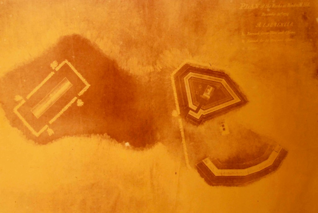
Obviously the barracks were sorely needed but the construction was slow. Historian Walter Schroder in his book about the Hessian troops says that by the end of 1777 there was a battery with six guns at Windmill Hill as well as a redoubt for 100 men. A separate barracks for 300 men and officers had been constructed close to the other barracks. He writes: “The entire area encompassed earthworks some 700 feet long by 200-300 feet in width. Abbatis – an entanglement of cut tree limbs serving a role similar to barbed wire in modern times –had been placed outside the entrenchments and earthworks to slow down and harass advancing enemy foot soldiers. **
April 18th, 1778: As we have at present no camp equipage (except some old tents for about 500 men) I think we should immediately erect a respectable work on Windmill Hill, capable of containing a Regiment, and not to be taken without breaking ground against it. The enemy should by every means in our power be prevented from establishing themselves unmolested on Windmill Hill, or any part of the Northern extremity of the Island, for if they should we shall find it extremely difficult to dispossess them…
..A trifling temporary work should by no means be constructed on Windmill Hill; to as it is the best spot on the Island for a work of consequence, and such a work will at one time or other be found necessary there, the erection of a trifling work would be throwing away so much time and money.
It is clear that Mackenzie considered Windmill Hill (Butts Hill) and important location and thought it should be well developed as a defensive fort.
May 1, 1778: The 54th regiment are to construct a Redoubt round the Barrack at Windmill Hill, for the present security of that post.
May 5, 1778: The 54th Regiment is employed at Windmill Hill in throwing up a work round the large Barrack there.
Here it seems like there is a defensive perimeter built around the Barracks and guard House. This gives it the outline that we can even see today.
May 8th 1778: The regiments of Landgrave and Ditfourth to be posed at Windmill Hill; under the Command of Major General Losbert. They consist of near 1,000 men, their field pieces would be of great service there, they may be depended upon for the defense of the works. And Major General Losbert is the Second in Command on the Island.
It is hard to imagine a thousand soldiers at the fort. Some would be in the barracks and some would be encamped around it.
1780, July: The French arrived on Aquidneck Island. Before they had settled, there was news the British were planning to attack. Washington authorized Rochambeau “to call up the militia of Boston and Rhode Island to aid his army build the works for the defense of the island.”
The Black Regiment was split between guarding munitions in Providence and guard duty on Aquidneck Island. Sixty-four members of the regiment were sent to Newport and were incorporated into the “Rhode Island Six Months Battalion.” The Black Regiment veterans were among the 600 men encamped in Portsmouth guarding Butts Hill Fort, Howland Ferry and Bristol Ferry. One white recruit, Peter Crandall, wrote: “We landed on the north end of the island near Butts Hill Fort and pitched our tents on a height of land near Butts Hill Fort …. our duty was to go through the manual exercise, keep up quarter guard, and work on the fort.” This remnant of the Black Regiment and The Six Month Battalion were there until Nov. 1780. They remained at Butts Hill to work on the fort after the remainder of the Continental Battalion joined French troops in marching to join Washington’s army. *** In the summer of 1780 they connected the redoubt and the former British barracks into one structure.
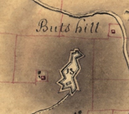
From French map 1780
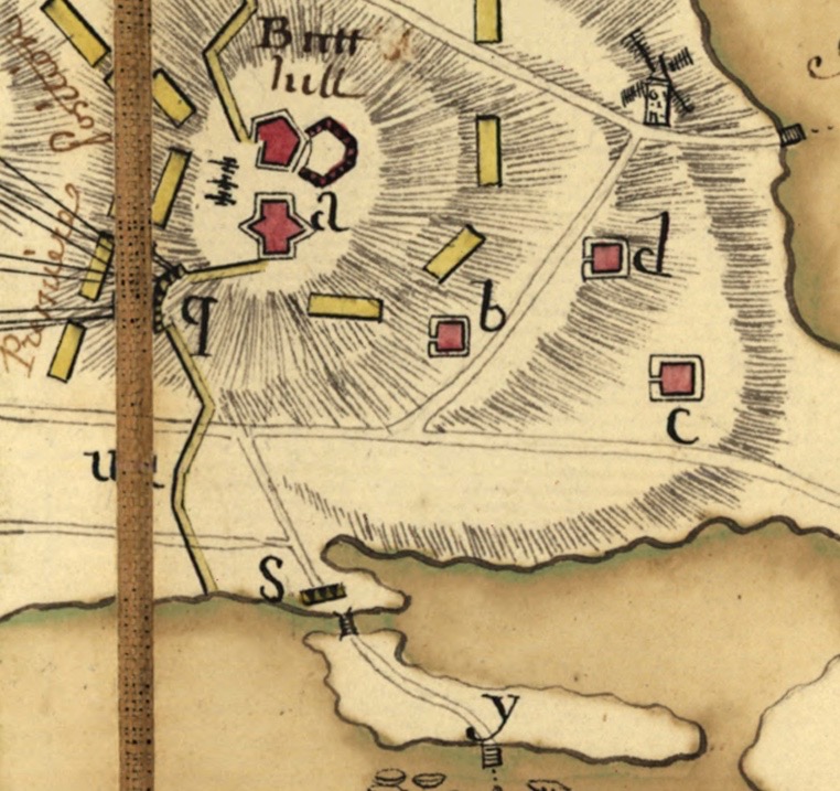
British (Fage) 1777
French map 1778
Sources:
*Diary of Frederick Mackenzie Vol. 1 and Vol. 2. Cambridge, Massachusetts, Harvard Press, 1930.
**Schroder, Walter. The Hessian Occupation of Newport and Rhode Island 1776-1779. Westminster, Maryland, Heritage Books, 2005. pg. 102.
***Kopek, Daniel M. They “fought bravely, but were unfortunate:” The True Story of Rhode Island’s Black Regiment.
Edward Fage – Plan of the Works at Windmill Hill, Dec. 31, 1777 (facsimile in PHS collection)
Plan de Rhodes-Island, et position de l’armée françoise a Newport. Library of Congress Collection.
Plan de Rhode Islande, les differentes operations de la flotte françoise et des trouppes Américaines commandeés par le major général Sullivan contre les forces de terre et de mer des Anglois depuis le 9 Aout jusqu’a la nuit du 30 au 31 du même mois que les Américains ont fait leur retraite 1778
During the War for Independence the hill that was known as Butts Hill or Windmill Hill became the location of Butts Hill Fort. The location provided a commanding view of the Eastern and Western sides of Aquidneck Island including East Main Road and West Main Road. It was a prime location for defensive fortifications.
North view from Butts Hill (postcard from PHS collection)
1776 – Americans built small battery at Butts Hill.
1776 – December 8th. British occupation of island begins and American forces escaped via the ferries. British forces take over the battery at Butts Hill.
1777 -September: British General Pigot forced Portsmouth residents to work three days a week on the construction of the earthworks that remain today. Butts Hill Fort became the most important position because it guarded locations where Patriot forces might invade the island – Bristol Ferry, Common Fence Point, Howland’s Ferry and Fogland Ferry. It was a fortified barracks for up to 200 troops.
1778 – July 29th: The French fleet was expected in Newport so the British abandoned the fort to reinforce lines around Newport. American General Sullivan and his troops were waiting in Tiverton for an opportunity to cross to Aquidneck Island.
1778,- August 9 – 11th. On the morning of August 9th during a drill for the crossing, General Sullivan discovered that the British had abandoned fortifications at Ft Butts. He sent troops across because he knew the ferries were unguarded and they could cross safely. By August 11, American troops took over Butts Hill Fort.
Edward Fage – Plan of the Works at Windmill Hill, Dec. 31, 1777 (facsimile in PHS collection)
1778, August 20th, General Sullivan hears that the French fleet had gone to Boston for repair and resupply. The Americans were shocked by this news.
1778, August 24th. General Sullivan begins to make preparations for a retreat from the island.
1778, August 29-30th – Battle of Rhode Island. The British came after the American troops to prevent them from retreating from the Island. This battle came to be known as the Battle of Rhode Island. The heights of Butts Hill Fort provided the American Commanders with a view of the battlefield – Butts Hill, Quaker Hill and Turkey Hill. Although the Americans occupied the fort for only 17 days, it was their command post during the battle. The Americans successfully retreated.
1778, September 1st. The British return to Butts Hill Fort.
1779, October. British forces leave Butts Hill Fort and Aquidneck Island. The Americans again occupied the fort, and in the summer of 1780 they connected the redoubt and the former British barracks into one structure.
1780, July: The French arrived on Aquidneck Island. Before they had settled, there was news the British were planning to attack. Washington authorized Rochambeau “to call up the militia of Boston and Rhode Island to aid his army build the works for the defense of the island.”
Plan de Rhodes-Island, et position de l’armée françoise a Newport. Library of Congress Collection.
The Black Regiment was split between guarding munitions in Providence and guard duty on Aquidneck Island. Sixty-four members of the regiment were sent to Newport and were incorporated into the “Rhode Island Six Months Battalion.” The Black Regiment veterans were among the 600 men encamped in Portsmouth guarding Butts Hill Fort, Howland Ferry and Bristol Ferry. One white recruit, Peter Crandall, wrote: “We landed on the north end of the island near Butts Hill Fort and pitched our tents on a height of land near Butts Hill Fort …. our duty was to go through the manual exercise, keep up quarter guard, and work on the fort.” This remnant of the Black Regiment and The Six Month Battalion were there until Nov. 1780. They remained at Butts Hill to work on the fort after the remainder of the Continental Battalion joined French troops in marching to join Washington’s army. **
1781, June: French troops leave Butts Hill Fort. Fort is abandoned. As Portsmouth recovers after the war, this land is unusable for agriculture and remains deserted.
1781, August: Five 18 pound guns with their carriages removed from Butts Hill to Easton Point
1783, June: RI assembly authorized sale at public auction of the gates, buildings and other installations
What happened to the land after the war is still somewhat of a mystery.
1850s Ward Map shows Butts Hill Fort, but no development of the land and no clear ownership. Butts family genealogy reveals that the Butts family moved away to Providence and other locations to practice their craft of rope making. They note that some of the land passes down through a daughter whose married name was Cook.
Civil War Era: There are reports that some militias use the fort for training purposes.
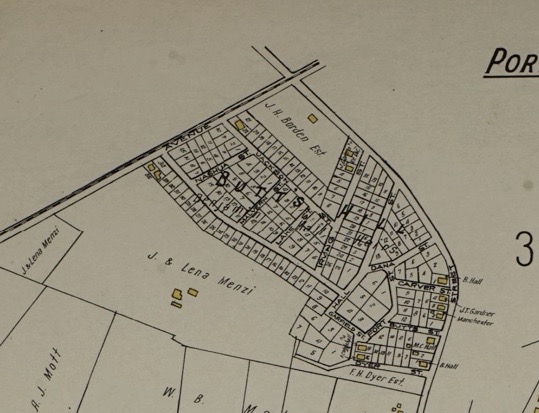
After the Civil War: Maps from the 1870s and 1885 clearly show the Fort as a prominent feature. During this time land evidence records show Charles Hicks Dyer and Charles Henry Dyer with ownership of the land around the fort. B. Hall Jr. also has a segment of Fort land.
1900: Notices appear in the newspapers for house lots for sale by Benjamin Hall Jr.
1908: The state of Rhode Island shows interest in making the land at Butts Hill Fort a state park.
Sanborn Map 1921
Circa 1910 Map
Newspaper ad 1900
1920s: Roderick Terry conveyed to Newport Historical Society, pieces of the land in 1923, 1924, and 1932.
Terry stipulated
That the fort would serve as a memorial or monument to the memory of those who fought in the American-Revolutionary War.
That said premises shall always retain the name of “Butts Hill Fort”.
That said premises shall never be used to make money.
That if the Newport Historical Society doesn’t take care of the fort, it would be transferred to the State of Rhode Island. These provisions continue to control the property to this day!
1968 the State of Rhode Island transferred the property to Town of Portsmouth.
Sources:
Butts, Francis B. “The Butts Family of Rhode Island – Genealogy and Biography” 1891
McBurney, Christian. The Rhode Island Campaign. Yardley, PA, Westholme Publishing, 2011.
Dearden, Paul. The Rhode Island Campaign of 1778: Inauspicious Dawn of Alliance, Providence, Rhode Island Publications Society, 1980.
The French in Newport – Newport Historical Society, Fall 2003-spring 2004.
Neimeyer, Charles P. The British Occupation of Newport Rhode Island 1776–1779. Army History No 74, Winter 2010.
As we look to preserving the earthworks Butts Hill Fort, I wondered about the land history. Who owned this piece of land we are trying to preserve? How has this tract of land been used throughout Portsmouth history. Finding the answers to those questions is not so easy. Although Portsmouth has kept excellent land records, my skills in tracking back ownership are somewhat lacking. Let me share what I have gleaned through maps, historical records and secondary sources. I have tried to confirm as much as I could through Portsmouth land records and genealogical records. This is a work in progress, so maybe those knowledgeable in family genealogies can help me to find confirmations or missing links.
Part 1 – From Land Grant to War for Independence
Land grant: I usually start research by looking at West’s Land Grant maps to identify the original owners. Looking at these maps led me to believe that the land was town owned for many years. I do have a confirmation of the Durfee family on that land because town records show that in February of 1729 Thomas Durfee left “a parcel called the Wind Mill Hill land” to son Gideon Durfee.
Land Grant to Durfee
1638 to after 1708: The Town of Portsmouth retained the property we know as Butt’s Hill. The Town, however, permitted a windmill to be erected so that the windmill was owned by other familiar Portsmouth families. The handing down of the Windmill and the land around it was recorded in the town records.
1657: William Cory and William Earl applied to the town council to trade a piece of land for land on Briggs Hill to build a windmill.
1665: The hill land (or pieces of it) was owned by Caleb Briggs.
1668: A windmill is erected by William Earle and William Cory. Cory is known as a carpenter and miller. Cory and Earle are brothers-in-law.
1682 (Feb 24, 1682). William Cory (carpenter and miller) in his will gave the windmill to his wife Mary. Mary traded land back to the town.
1721: Caleb Bennett inherits the windmill from father Robert Bennett. Robert had married Anne Cory. Perhaps the windmill and land came from her family.
Will – To Caleb Bennett from father Robert: Transcription of Land Evidence Record in Rhode Island Genealogical Biographies
1725 January 15, John Butts bought of Caleb Bennett the windmill and about one rood of land (about a quarter of an acre) on Windmill Hill. This I was able to confirm through Portsmouth land evidence.
Sale – Bennett to Butts – Land Evidence Records of the Town of Portsmouth
At this point the area was known as Windmill Hill or Butts Hill. The Fage Maps called it “Windmill Hill.” In the family genealogies I don’t find evidence that John Butts or his son John Butts, Jr. were millers or farmers. There was a Butts family homestead that was torn down in the 1870s. Before the War for Independence some members of the Butts family, including John Butts, Jr., were ship owners.
According to a Butt’s family genealogy: “The name of the fort was given in honor of John Butts and his family for their loyalty, and aid given patriot Army during the struggle for independence. John Butts occupied the homestead of the Butts family, and was engaged in the shipping interests of the Island. The *War of the Revolution” was a great disaster to him; the British warships captured or destroyed his little fleet of vessels and the army swept everything from his land. He was greatly respected by the people among whom he lived, and the soldiers of the Patriot Army. To his honor and patriotism the fort which they struggled to defend was named, and from that time has been known as “Fort Butts.” It is also said that the industry of the Island is largely due to his energy and influence. He married Susanna, daughter of William and Susanna Cornell, of Portsmouth, August 17, 1767.” **
Looking at their genealogies, the family didn’t seem to come back to the land at the end of the War. Family members were active in rope making not milling or farming and moved to other parts of the state.
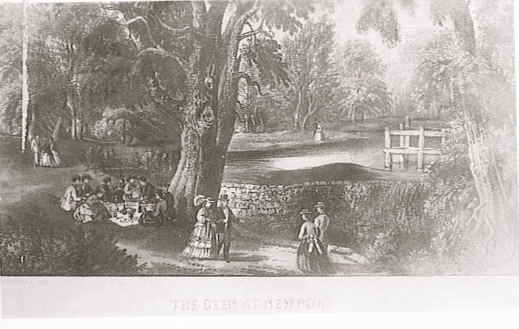
A number of years ago I was privileged to take a tour of the Glen with arborist Matt Largess. He commented that the Glen itself was one of the few areas on the island with old growth trees because the British were not able to easily cut down the trees during the occupation of the Island. That explained why in the 1850s the Glen would be an attraction because its natural beauty had been preserved.
Fage Map shows woods near Fogland Redoubt
Currier and Ives The Glen 1850s
When Maj. Frederick Mackenzie of the British forces arrived on the island in December of 1776, the winter was mild and he writes little about woodcutting in his diary. But the winter of 1778 was extremely cold. On June 15, 1778 Mackenzie wrote: “The consumption of Wood for the Garrison last winter was about 300 cords per week. It would be less expensive to send Coals from England.” A cord of wood measures 8 feet long, 4 feet high and 4 feet wide. It wasn’t only the troops that needed wood to survive a cold winter – it was also needed by those colonists who stayed on the island. Timber in Portsmouth was not always easy to cut. Mackenzie records: “Officer and 36 British went into the Country today, to be employed in cutting wood in a large Swamp on this side of Fogland Ferry, for the use of the Garrison. It is computed that there are about 400 Cords in the Swamp, but it cannot be got at but during a hard frost.” Figuring out where that swampy area was is difficult for us, but Edward West’s article “Lands of Portsmouth” notes two Swamps in the area of Mint Water Brook on either side of East Main Road.
At first the British and Hessians felled the trees closest to their camps. The Hessians had a camp above Fogland Ferry. They continued to cut further away until there were no trees to cut and burn. Mackenzie records that they then turned to cutting down orchards next on Common Fence Point and other locations. After the orchards, all other sources of wood were eyed. Vacant houses, wood carriages, and even wooden farm tools went into the wood supply. Mackenzie writes on December 6th, 1778: Every step is being taken to supply fuel: All the timber trees on the island are cutting down and the old wharves will be broken up.” Vacant houses were taken apart and the wood was used for fuel. Rail fences were taken apart and burned. On December 13th his diary entry reads: “All the carriages that can be collected on the Island are employed in bringing in the wood which is cut by the party out on the island.” “Turf” was cut on Brenton’s Neck and used for fuel. When the island was exhausted, they sent fleets out to collect wood on Conanicut, Block Island and Long Island.
When the Occupation was over, those remaining on the island had a difficult time rebuilding homes and barns. Many Portsmouth farmers turned to wood from Tiverton to begin to restore their buildings.
Sources:
Diary of Frederick Mackenzie Giving a Daily Narrative of His Military Service as an Officer of the Regiment of Royal Welch Fusiliers during the Years 1775-1781 in Massachusetts, Rhode Island, and New York, Volume II
Edward West: ” The Lands of Portsmouth, RI” – Rhode Island Historical Society Journal, July, 1932.
Anne Hutchinson School has been in the news lately. I had little information about the school itself, but I have been looking through a folder of old clippings on loan from Jim Garman, and I came across an article about the dedication. There were familiar names in the article. H. Frank Anthony was the chairman of the school board. Howard Hathaway was the President of the Town Council. The Weyerhaeuser Lumber Company provided the land for the school.
Hutchinson School at Dedication 1928
The dedication ceremony itself began with the children of Quaker Hill School singing patriotic songs. From the article it appears that 150 students had been crowded into Quaker Hill School with half day lessons and they would be attending the new school. The representative of the Rhode Island Department of Education, Dr. Charles Carroll, expressed pleasure that the school was named for Anne Hutchinson. Anne, he said, “established the first class for home education in the United States”. Carroll noted that the town voted to establish a school in 1716 (Southermost School built int 1725) and in 1916 the town built Quaker Hill School (now the current administration building) which was considered the finest rural school house in the state. Town Clerk George Hicks noted that Weyerhaeuser had conveyed the three acre property to the town as a free gift. Hicks talked about attending Bristol Ferry School and how careful the students were to not mar any surfaces.
Every room of the school had potted plants and cut flowers from Mr. Vanderbilt’s Oakland Farm greenhouses. Pictures were loaned by noted Portsmouth artist Sarah Eddy.
The article describes the building:
“The new building, completed and up-to-date in brick, with four classrooms, teachers sitting room and office for the superintendent. In the basement are the coatrooms, with arrangements for children’s coats, and a playroom large enough for all the pupils. The sanitary arrangement are the best. The artesian well was put down by Whitworth and Bridge. Charles F. Grinnell and Son of Tiverton were the contractors for the entire building. The many large windows make the lighting in the class rooms perfect. These rooms are two west of the corridor, and two east, with office rooms branching from the classrooms. The building cost, completed, approximately $35,000. The grading on the lawn was by Howard Hathaway.”
The diary of Frederick Mackenzie gives us a remarkable record of what was happening in Portsmouth during the British Occupation of Aquidneck Island (December 8, 1776 to October 1779).
Mackenzie provides a very readable account of what was going on with the American side as well as the British and Hessian. He spent much of his time in the Portsmouth area. A short time after he arrived he provided this glowing account of Quaker Hill before the destruction began.
There is a hill about 7 miles from Newport, and on the Eastern side of this Island called Quaker Hill, from there being a Quaker meeting-house on it, from whence there is a very fine view of all the N. part of the Island, and the beautiful bays and inlets, with the distant view of towns, farms, and cultivated lands intermixed with woods, together with the many views of the adjacent waters, contribute to make this, even at this bleak season of the year, the finest, most diversified, and extensive prospect I have seen in America. The Ships of War are in such positions as to make it appear as if they were placed there only to add to the beauty of the Picture. In the beginning of summer this must be a delightful view, and I should think hardly to be equalled in America, or any other country.
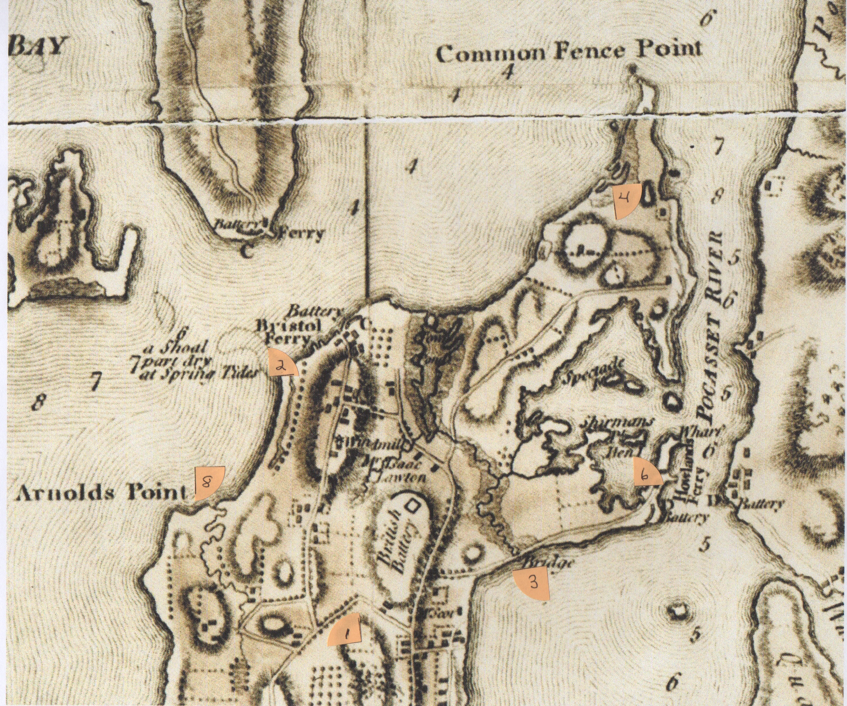
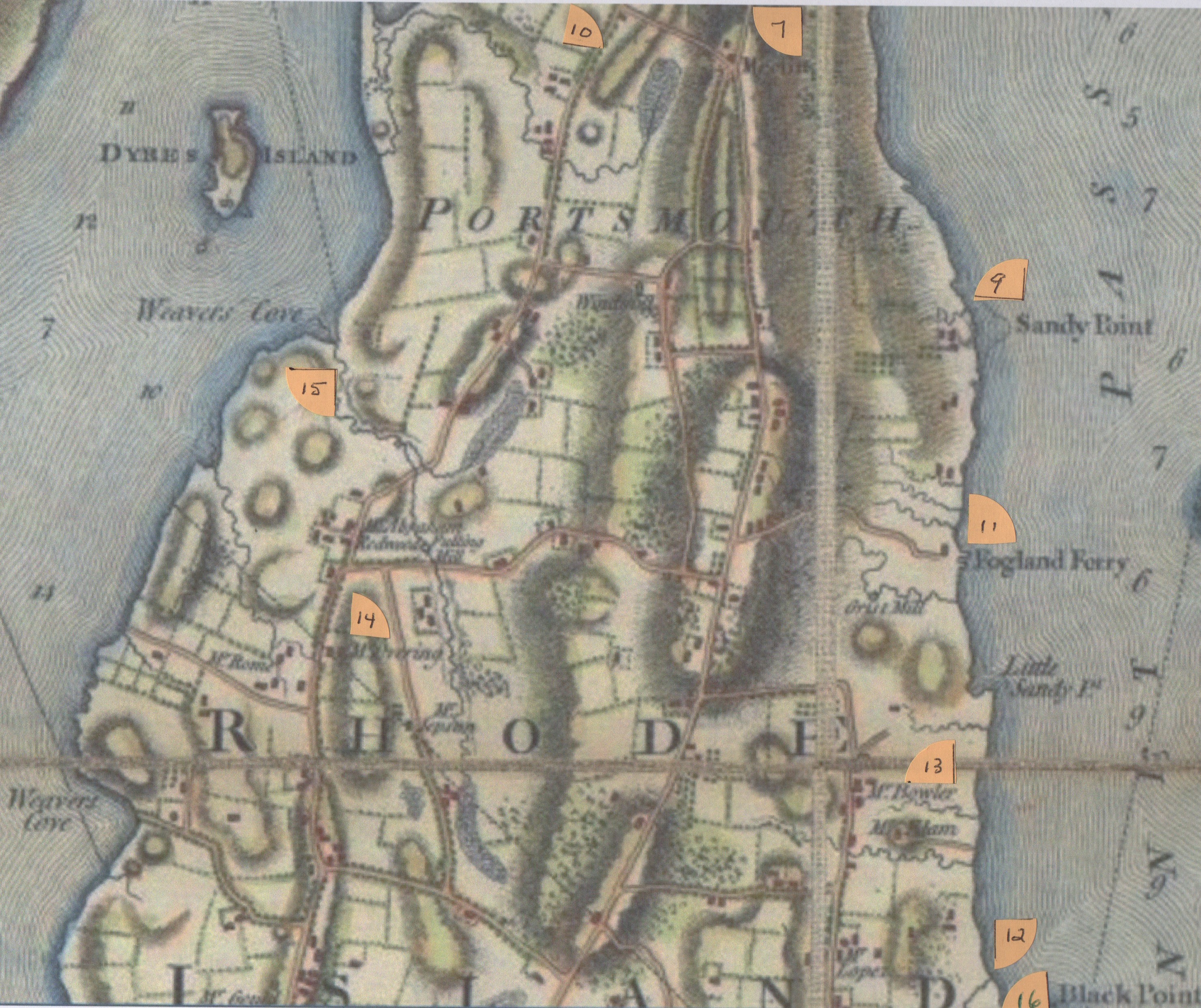
Mackenzie comments on troop movements throughout his diary, but in one particular place he gives us a detailed account of the stations of the British and Hessians. As you will see from the map I have marked, the troops were stationed throughout Portsmouth.
June 13 1778
The following are the present stations of the troops on this Island. – Bunau’s Regt – At Windmill hill: ( Butt’s Hill). This Regt furnishes all the posts at the North End, in front of a line drawn from their right & left to the Shore.
22d Regt At Quaker hill on the East road, their right to the Seconnet. They furnish the posts on the East shore, from Ewing’s, as far as McCurrie’s. (Our McCorrie Beach area know as Sandy Point at that time.)
43rd Regt On the left of the West road, near Turkey hill: four Companies with their right to the W. Road; and four Companies, 200 yards to their left. They furnish the posts on the West shore, from the left of Bunau’s Regt as far as the Creek of Layton’s Mills (Lawton Mills).
A Detachment of 80 Hessians from the three Battalions in Newport, at Fogland Ferry (End of Glen Road). This detachment furnishes the post at Fogland, and Patroles as far as little Sandy-point, on their right (Little Sandy Point is what we call Sandy Point today).
54th Regt At the Blacksmith’s on the E. road. Their right to the road, and to that which leads up from Lopez’s house (Aaron Lopez’s house and bay (Greenvale area today); furnishing the posts from Sandy point to Black point.
All the abovementioned Troops report to General Smith, and furnish a chain of post and patroles from Black point on the E. side, round to Layton’s (Lawton’s) Creek on the West.
Later in the summer he writes of Hessians moving from their encampment at Bowler’s House to Mr. Overing’s House (Overing – Prescott House at the Portsmouth Middletown line). The 54th Regiment moves to the artillery redoubt at Bristol Ferry, Common Fence and Howland’s Bridge. The rebels had guns on Gould Island in hopes of covering a retreat through Howland Neck. The frigate Sphinx is moored off Arnold Point.
I have placed numbers on the Blaskowitz Map to give you an approximation of the encampment areas mentioned.
Windmill Hill (Butts Hill)
Bristol Ferry
Howland Bridge
Common Fence
Unmarked
Howland Neck
Quaker Hill
Arnold Point
McCurry (McCorrie Point) called Sandy Point in those days
Turkey Hill
Fogland Ferry (end of Glen Road)
Lopez Bay (Greenvale area)
Metcalf Bowler’s House
Overings House (Prescott)
Layton (Lawton) Mill Creek
Black Point
British and Hessian Troop Locations
From Diary of Frederick Mackenzie Giving a Daily Narrative of His Military Service as an Officer of the Regiment of Royal Welch Fusiliers during the Years 1775-1781 in Massachusetts, Rhode Island, and New York, Volume II